UPSC Prelims 2024 Analysis
Subject-Wise MCQ Distribution
- Polity: High representation with 15-20 questions, focusing on constitutional articles, governance, and recent amendments. Analytical abilities were essential to tackle assertion-based and statement-type questions.
- Economy: Approximately 12-15 questions, heavily tilted towards current economic developments, policies, and budget-related topics. A mix of static concepts from NCERT and dynamic updates was necessary.
- Environment & Ecology: 18-20 questions, with a strong emphasis on climate change, international agreements, and conservation efforts. Match the following questions played a significant role in this section.
- History: 12-14 questions, balanced between ancient, medieval, and modern, with increasing weightage on cultural aspects. Many questions required a combination of NCERT knowledge and historical maps for better context.
- Geography: 10-12 questions, mostly applied concepts like map-based and environmental geography questions.
- Science & Technology: 8-10 questions, leaning towards application-based knowledge on recent innovations and space technology.
- Current Affairs: 15-18 questions, interwoven with other subjects, often requiring assertion-reasoning skills to connect facts.

Difficulty Analysis
- Easy: ~30% of questions were straightforward and could be attempted with basic NCERT knowledge.
- Moderate: ~50% required analytical abilities, conceptual clarity, and elimination tactics.
- Difficult: ~20% were tricky, involving multi-layered reasoning or obscure facts.

Variations in Question Framing
- Statement-based MCQs: 60% of questions were framed in a two-statement or three-statement format, testing comprehension, elimination skills, and analytical abilities.
- Assertion-Reasoning: 13% of the questions assessed logical connections between concepts, requiring critical thinking.
- Match the Following: 10% of the questions required mapping terms with their definitions, locations, or features, particularly in Geography and Environment.
- Standalone Questions: 25% were direct, fact-based questions, but even these often required cross-referencing with maps or historical events.
- Notably, in 2024, UPSC introduced three-column Match the Following MCQs, increasing question complexity and demanding better comprehension skills.

Key Learnings for Future Preparation
- Integrated Approach: Focus on interlinking static NCERT subjects with current affairs, as many questions have contextual relevance.
- Master the Basics: A strong foundation in NCERTs is crucial for tackling conceptual questions, especially in Polity, History, and Geography.
- Develop Analytical Abilities: Statement-based and assertion-reasoning questions require critical thinking and elimination tactics.
- Focus on Trends: Emphasize high-yield topics like Environment, Economy, and Current Affairs to maximize scoring potential.
- Revise Maps and Schematics: Geography and Environmental questions often require map-based knowledge and spatial reasoning to answer correctly.
Subject-Wise Answer Key
QUESTION 1
GS
Hard
Indian Geography
Prelims 2024
Consider the following information:
| Waterfall | Region | River |
|---|---|---|
| 1. Dhuandhar | Malwa | Narmada |
| 2. Hundru | Chota Nagpur | Subarnarekha |
| 3. Gersoppa | Western Ghats | Netravati |
In how many of the above rows is the given information correctly matched?
A. Only one
B. Only two
C. All three
D. None
QUESTION 2
GS
Easy
Physical Geography
Prelims 2024
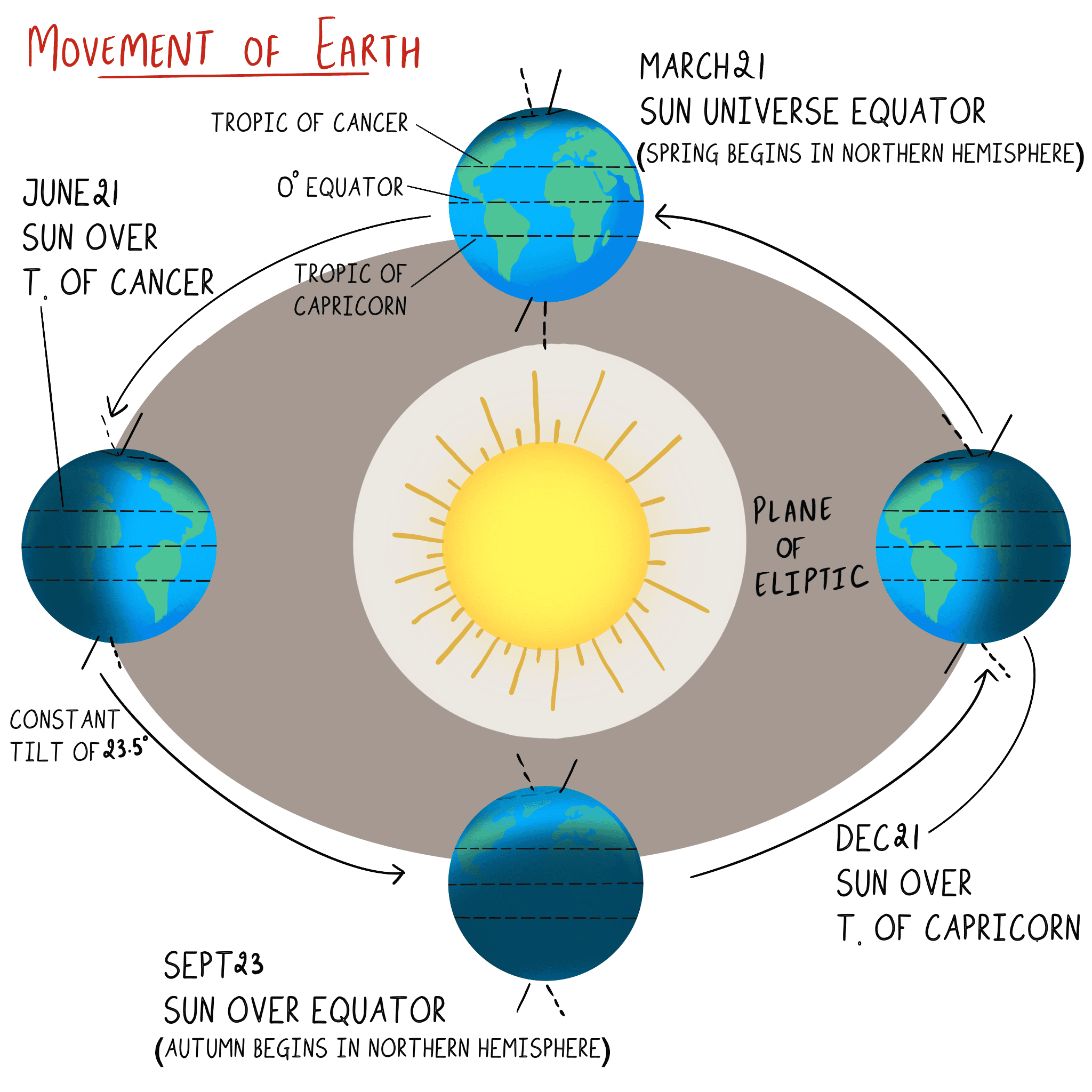
On June 21 every year, which of the following latitude(s) experience(s) a sunlight of more than 12 hours?
- Equator
- Tropic of Cancer
- Tropic of Capricorn
- Arctic Circle
Select the correct answer using the code given below :
A. 1 only
B. 2 only
C. 3 and 4
D. 2 and 4
QUESTION 3
GS
Easy
Physical Geography
Prelims 2024
Which of the following is/are correct inference/inferences from isothermal maps in the month of January?.
- The isotherms deviate to the north over the ocean and to the south over the continent.
- The presence of cold ocean currents, Gulf Stream and North Atlantic Drift make the North Atlantic Ocean colder and the isotherms bend towards the north.
Select the answer using the code given below :
A. 1 only
B. 2 only
C. Both 1 and 2
D. Neither 1 nor 2
QUESTION 4
GS
Hard
World Geography
Prelims 2024
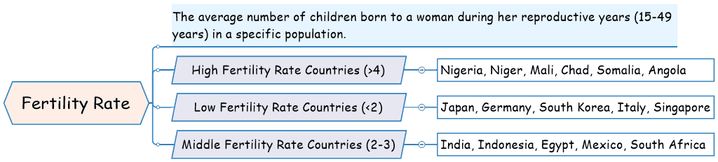
Consider the following countries :
- Italy
- Japan
- Nigeria
- South Korea
- South Africa
Which of the above countries are frequently mentioned in the media for their low birth rates, or ageing population or declining population?
A. 1, 2 and 4
B. 1, 3 and 5
C. 2 and 4 only
D. 3 and 5 only
QUESTION 5
GS
Easy
Physical Geography
Prelims 2024
With reference to "water vapour", which of the following statements is/are correct?
- It is a gas, the amount of which decreases with altitude.
- Its percentage is maximum at the poles.
Select the answer using the code given below :
A. 1 only
B. 2 only
C. Both 1 and 2
D. Neither 1 nor 2
QUESTION 6
GS
Medium
World Geography
Prelims 2024
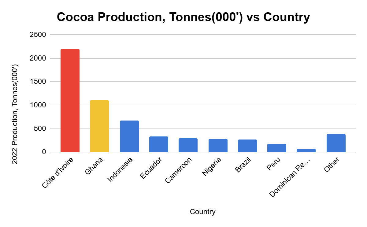
Which of the following countries are well known as the two largest cocoa producers in the world?
A. Algeria and Morocco
B. Botswana and Namibia
C. Côte d'Ivoire and Ghana
D. Madagascar and Mozambique
QUESTION 7
GS
Hard
World Geography
Prelims 2024
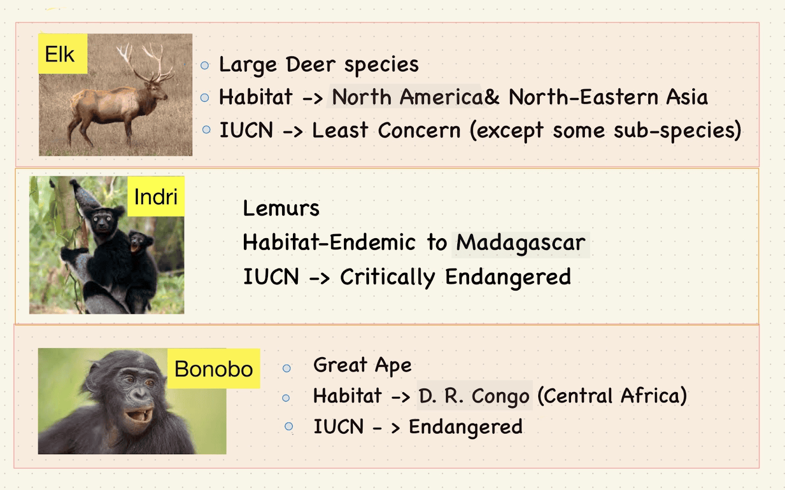
Consider the following pairs:
Country - Animal found in its natural habitat
1. Brazil - Indri
2. Indonesia - Elk
3. Madagascar - Bonobo
How many of the pairs given above are correctly matched ?
A. Only one
B. Only two
C. All three
D. None
QUESTION 8
GS
Easy
World Geography
Prelims 2024
The longest border between any two countries in the world is between :
A. Canada and the United States of America
B. Chile and Argentina
C. China and India
D. Kazakhstan and Russian Federation
QUESTION 9
GS
Medium
World Geography
Prelims 2024
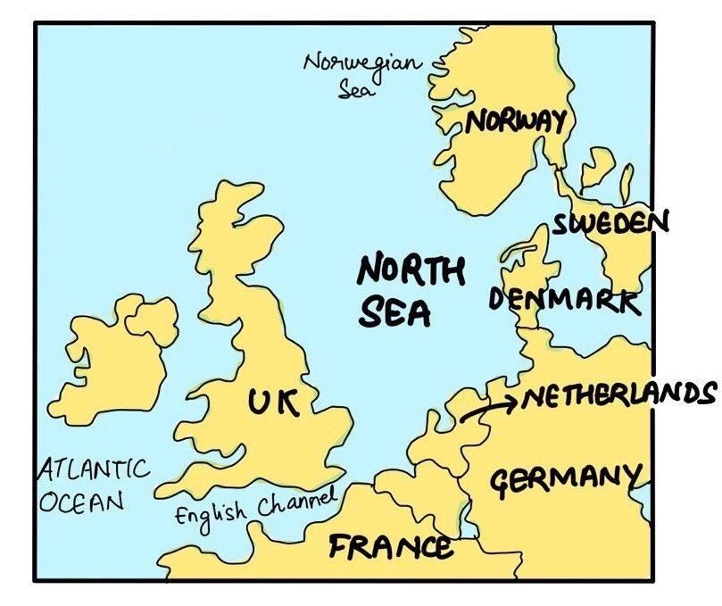
Consider the following countries :
- Finland
- Germany
- Norway
- Russia
How many of the above countries have a border with the North Sea?
A. Only one
B. Only two
C. Only three
D. All four
QUESTION 10
GS
Medium
World Geography
Prelims 2024
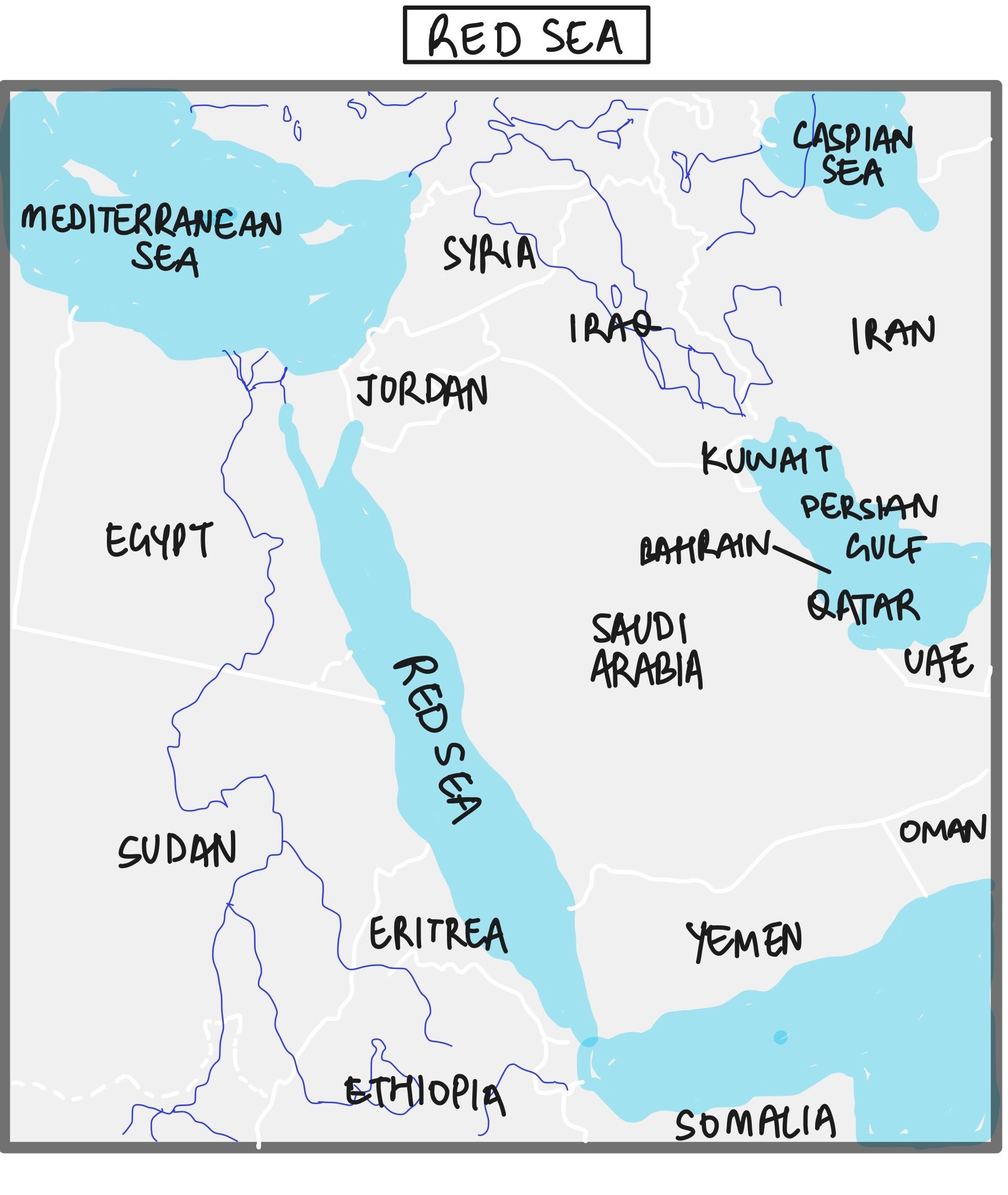
Consider the following statements:
Statement-I : Sumed pipeline is a strategic route for Persian Gulf oil and natural gas shipments to Europe. Statement-II : Sumed pipeline connects the Red Sea with the Mediterranean Sea.
Which one of the following is correct in respect of the above statements?
A. Both Statement-I and Statement-II are correct and Statement-II explains Statement-I
B. Both Statement-I and Statement-II are correct, but Statement-II does not explain Statement-I
C. Statement-I is correct, but Statement-II is incorrect
D. Statement-I is incorrect, but Statement-II is correct
QUESTION 11
GS
Hard
Indian Geography
Prelims 2024
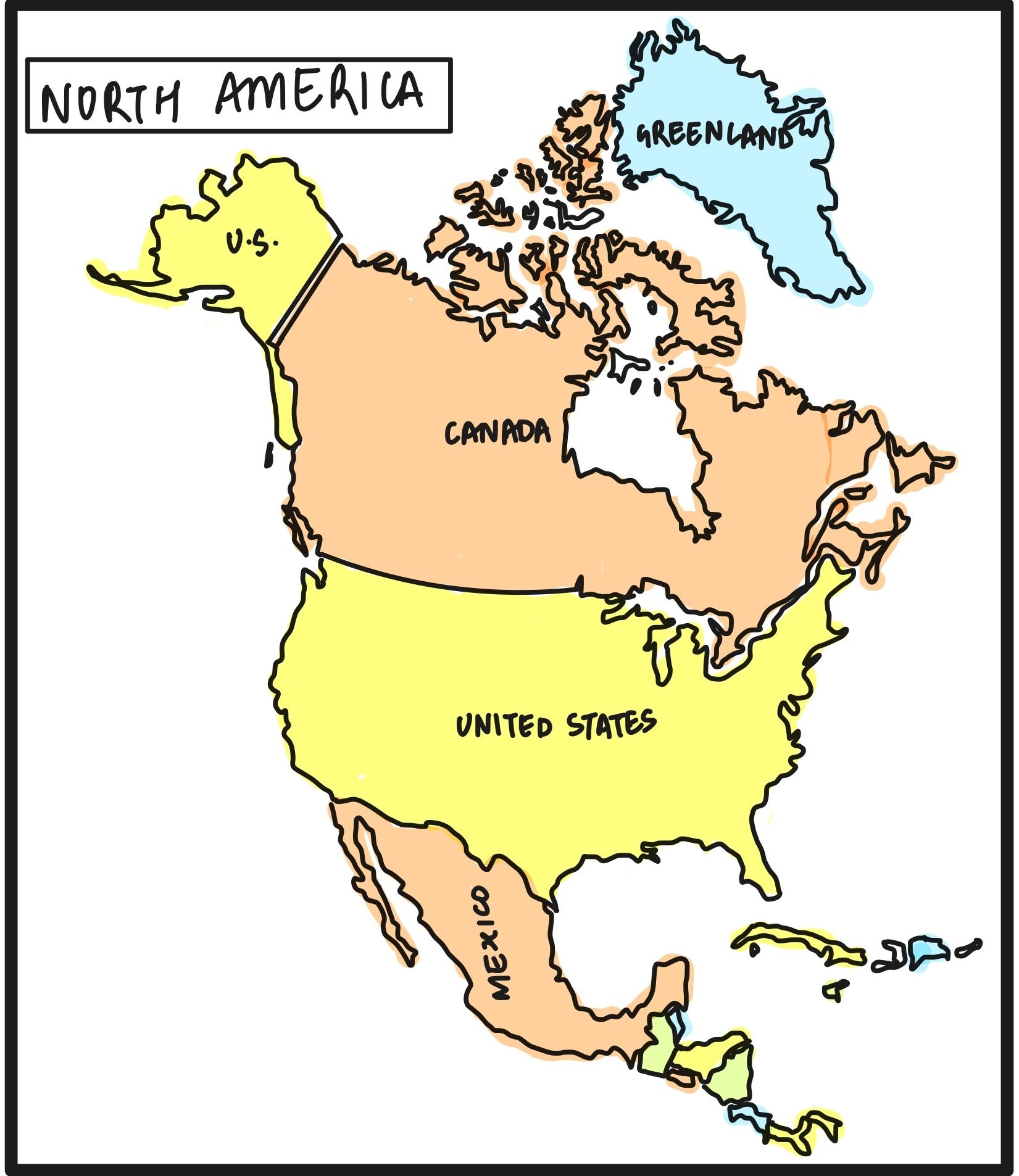
Consider the following airports:
- Donyi Polo Airport
- Kushinagar International Airport
- Vijayawada International Airport
In the recent past, which of the above have been constructed as Greenfield projects?
A. 1 and 2 only
B. 2 and 3 only
C. 1 and 3 only
D. 1, 2 and 3
QUESTION 12
GS
Easy
Physical Geography
Prelims 2024
With reference to "Coriolis force”, which of the following statements is/are correct?
- It increases with increase in wind velocity.
- It is maximum at the poles and is absent at the equator.
Select the answer using the code given below :
A. 1 only
B. 2 only
C. Both 1 and 2
D. Neither 1 nor 2
QUESTION 13
GS
Easy
Physical Geography
Prelims 2024
Consider the following statements:
Statement-I: Thickness of the troposphere at the equator is much greater as compared to poles. Statement-II: At the equator, heat is transported to great heights by strong convectional currents.
Which one of the following is correct in respect of the above statements?
A. Both Statement-I and Statement-II are correct and Statement-II explains Statement-I
B. Both Statement-I and Statement-II are correct, but Statement-II does not explain Statement-I
C. Statement-I is correct, but Statement-II is incorrect
D. Statement-I is incorrect, but Statement-II is correct
QUESTION 14
GS
Medium
World Geography
Prelims 2024
Consider the following statements :
- The Red Sea receives very little precipitation in any form.
- No water enters the Red Sea from rivers.
Which of the statements given above is/are correct?
A. 1 only
B. 2 only
C. Both 1 and 2
D. Neither 1 nor 2
QUESTION 15
GS
Medium
Indian Geography
Prelims 2024
With reference to the Himalayan rivers joining the Ganga downstream of Prayagraj from West to East, which one of the following sequences is correct?
A. Ghaghara – Gomati – Gandak – Kosi
B. Gomati - Ghaghara – Gandak – Kosi
C. Ghaghara – Gomati – Kosi – Gandak
D. Gomati - Ghaghara - Kosi - Gandak
QUESTION 16
GS
Medium
World Geography
Prelims 2024
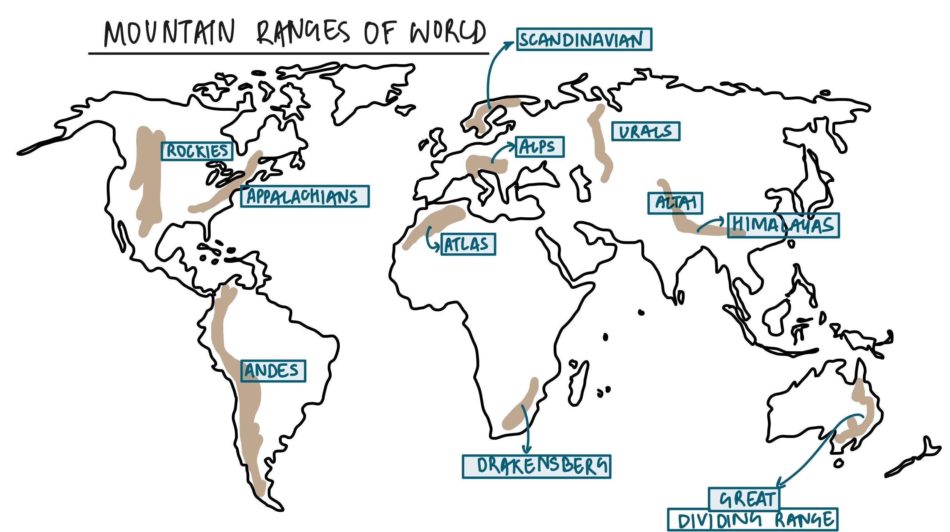
Consider the following information :
| Region | Name of the mountain range | Type of mountain |
|---|---|---|
| 1. Central Asia | Vosges | Fold mountain |
| 2. Europe | Alps | Block mountain |
| 3. North America | Appalachians | Fold mountain |
| 4. South America | Andes | Fold mountain |
In how many of the above rows is the given information correctly matched?
A. Only one
B. Only two
C. Only three
D. All four
QUESTION 17
GS
Hard
Indian Geography
Prelims 2024
Consider the following :
- Cashew
- Papaya
- Red sanders
How many of the above trees are actually native to India?
A. Only one
B. Only two
C. All three
D. None
QUESTION 18
GS
Easy
Physical Geography
Prelims 2024
Consider the following:
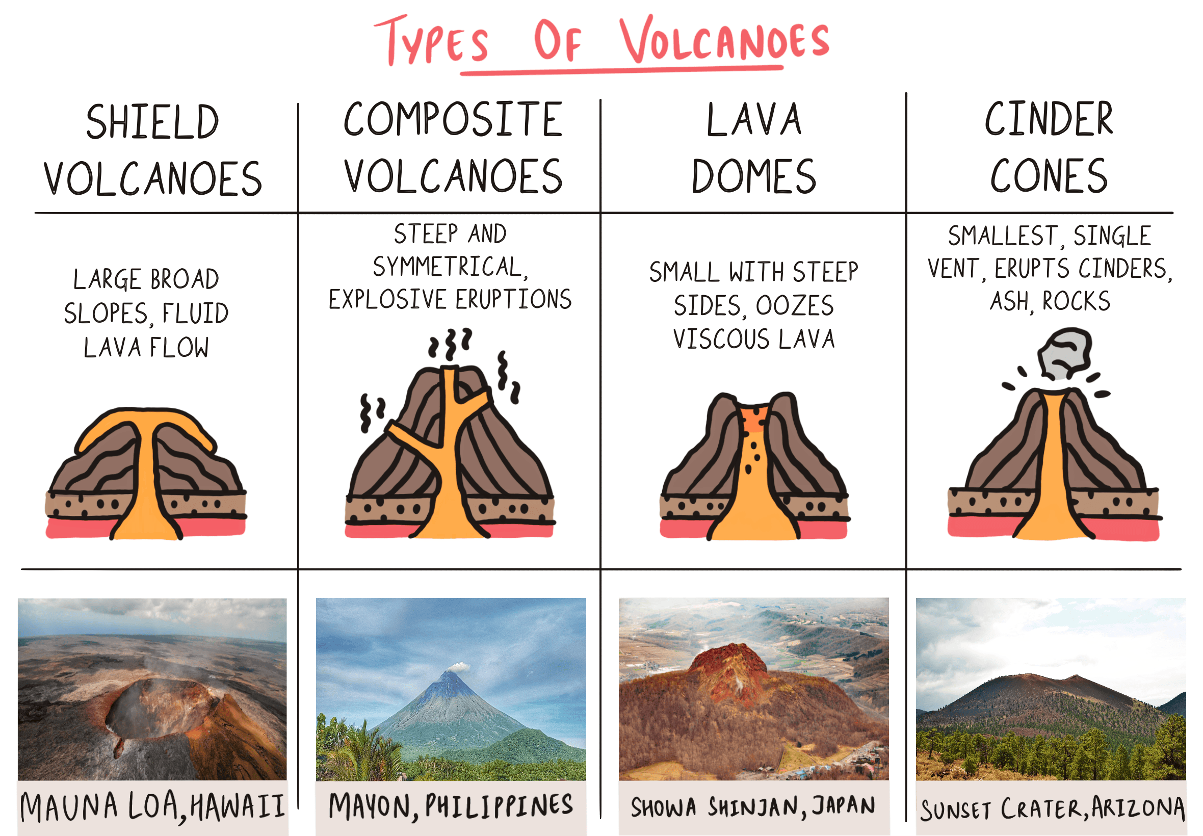
- Pyroclastic debris
- Ash and dust
- Nitrogen compounds
- Sulphur compounds
How many of the above are products of volcanic eruptions?
A. Only one
B. Only two
C. Only three
D. All four
QUESTION 19
GS
Easy
Physical Geography
Prelims 2024
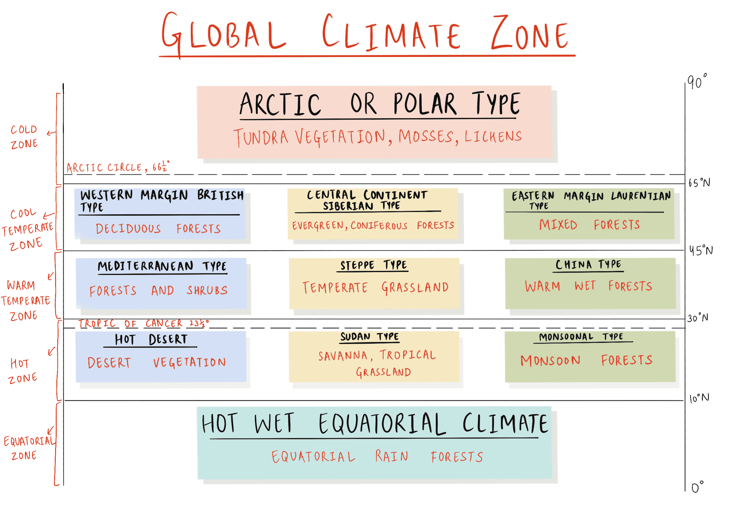
Consider the following description:
- Annual and daily range of temperatures is low.
- Precipitation occurs throughout the year.
- Precipitation varies between 50 cm - 250 cm.
What is this type of climate?
A. Equatorial climate
B. China type climate
C. Humid subtropical climate
D. Marine West coast climate
QUESTION 20
GS
Medium
Physical Geography
Prelims 2024
Consider the following statements :
Statement-I: Rainfall is one of the reasons for weathering of rocks. Statement-II: Rain water contains carbon dioxide in solution. Statement-III: Rain water contains atmospheric oxygen.
Which one of the following is correct in respect of the above statements?
A. Both Statement-II and Statement-III are correct and both of them explain Statement-I
B. Both Statement-II and Statement-III are correct, but only one of them explains Statement-I
C. Only one of the Statements II and III is correct and that explains Statement-I
D. Neither Statement-II nor Statement-III is correct
