Analyse & practice 14 years of PYQs to crack UPSCPractice Now

UPSC Prelims 2023 Analysis

Subject-Wise MCQ Distribution

  • Environment & Ecology had the highest weight (17 questions), as expected due to the combined exam of CSE and IFS. Many questions required analytical abilities and knowledge of maps to answer correctly.
  • Economy (16 questions) and Polity (15 questions) remained major focus areas. A combination of static NCERT concepts and current economic updates like the budget was essential.
  • History questions predominantly focused on Art and Culture, while the remaining topics were evenly distributed among Ancient, Medieval, and Modern History. Many required knowledge of historical maps to contextualize answers.
  • International Relations (10 questions) was a major surprise, emphasizing geopolitical events. Reading newspapers and investing time in Atlas and maps was helpful for tackling these questions.
     
Subject-Wise Weightage
Subject-Wise Weightage in UPSC Prelims 2023

Difficulty Analysis

  • Easy Questions (20): Required basic NCERT knowledge.
  • Medium-Level Questions (45): Demanded strong analytical abilities and multi-concept integration (e.g., linking budget policies with economic fundamentals).
  • Hard Questions (35): Designed to test deep conceptual clarity and the ability to tackle match the following and assertion-based formats.
Difficulty-Level Distribution
Difficulty-Level Distribution in UPSC Prelims 2023

Variations in Question Framing

  • The largest portion of the paper (47 questions) comprised multi-statement, non-eliminable questions, requiring candidates to determine how many statements were correct (e.g., "Only one," "Only two"). This tested analytical abilities and assertion-reasoning skills.
  • UPSC deliberately reduced reliance on elimination techniques, making conceptual clarity even more crucial.
  • 18 Assertion-Reason-based questions added further complexity.
  • The impact of this difficulty was reflected in the cut-off marks—the general category cut-off was just 75.41, the lowest in UPSC history.
Variations of Questions
Variations of Questions in UPSC Prelims 2023

Static vs Current Affairs Distribution

  • Static Questions (63%): Covered core UPSC Prelims test paper themes, such as constitutional articles, historical events, and core geography topics.
  • Current Affairs (37%): Focused heavily on global events, including wars, regime changes, and resource distribution (e.g., cobalt production). These often required analyzing maps and integrating static knowledge with recent developments.
     

Key Learnings for Future Preparation

  • The UPSC Prelims 2023 exam tested a mix of conceptual clarity, analytical abilities, and current affairs awareness.
  • High-weightage subjects like Environment, Economy, and Polity should be prioritized.
  • Strengthening NCERT basics is crucial, especially for Polity, History, and Geography.
  • Developing analytical abilities will help tackle assertion-reason and match the following questions effectively.
  • Maps are essential for Geography, International Relations, and Environment topics.
  • Aspirants must prepare for diverse question formats, including multi-statement, assertion-based, and budget-related economic questions.
The UPSC Prelims 2023 paper balanced factual recall with analytical reasoning, focusing on Environment, Economy, and Polity. The exam emphasized conceptual clarity and current affairs integration. A strategic preparation approach, covering both static and dynamic topics, is key for success.

QUESTION 1

EasyPhysical GeographyPrelims 2023

With reference to the Earth's atmosphere, which one of the following statements is correct?

A. The total amount of insolation received at the equator is roughly about 10 times of that received at the poles.

B. Infrared rays constitute roughly twothirds of insolation.

C. Infrared waves are largely absorbed by water vapour that is concentrated in the lower atmosphere.

D. Infrared waves are a part of visible spectrum of electromagnetic waves of solar radiation.

Answer: C

Explanation

  • While it is true that the equator receives more direct sunlight compared to the poles, the actual difference in insolation is not as large as ten times. The difference in insolation between the equator and poles is primarily due to the curvature of the Earth and the tilt of its axis, resulting in varying angles at which sunlight reaches different latitudes.

  • Insolation includes various wavelengths, such as visible light, ultraviolet rays, and infrared rays, but infrared rays do not constitute two-thirds of it.

  • Water vapour is a greenhouse gas that absorbs infrared radiation emitted by the Earth's surface. This absorption contributes to the greenhouse effect and helps regulate the Earth's temperature. Hence, this is the correct statement.

  • Infrared waves are not part of the visible spectrum; they have longer wavelengths than visible light.


QUESTION 2

HardIndian GeographyPrelims 2023

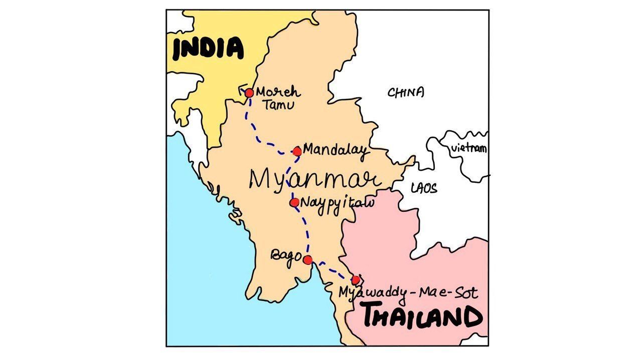
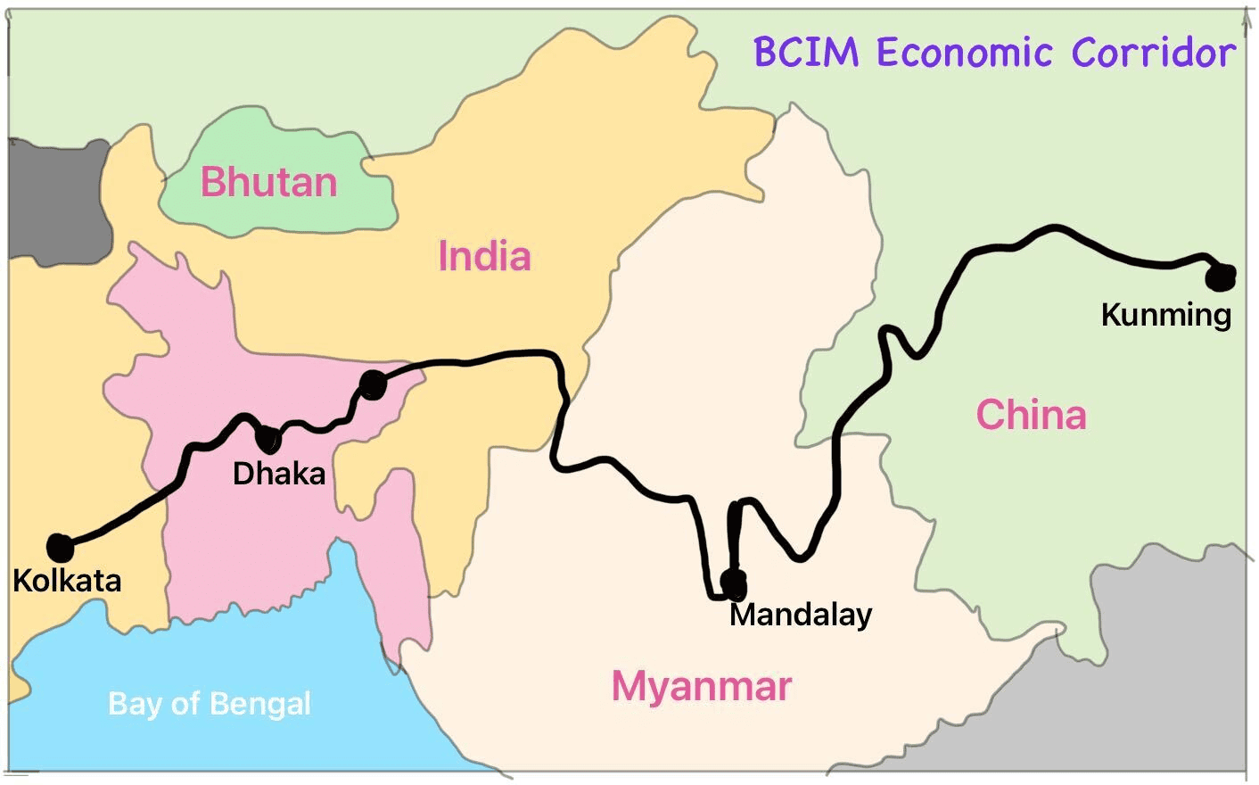
With reference to India's projects on connectivity, consider the following statements:

  1. East-West Corridor under Golden Quadrilateral Project connects Dibrugarh and Surat.
  2. Trilateral Highway connects Moreh in Manipur and Chiang Mai in Thailand via Myanmar.
  3. Bangladesh-China- India-Myanmar Economic Corridor connects Varanasi in Uttar Pradesh with Kunming in China.

How many of the above statements are correct?

A. Only one

B. Only two

C. All three

D. None

Answer: D

Explanation

  • Statement 1 is incorrect: The East-West Corridor is a part of the National Highways Development Project (NHDP) in India, which aims to connect Silchar in Assam to Porbandar in Gujarat. It does not connect Dibrugarh in Assam and Surat in Gujarat. 

QUAD

  • Statement 2 is incorrect:  The Trilateral Highway is a connectivity project that aims to connect Moreh in Manipur, India, with Mae Sot in Thailand via Myanmar. It is an important infrastructure project to enhance trade, connectivity, and people-to-people ties among the three countries.

imt

Statement 3 is incorrect:  The Bangladesh-China-India-Myanmar Economic Corridor (BCIM) is a proposed economic corridor that aims to connect Kunming in China with Kolkata in India, passing through Myanmar and Bangladesh. Varanasi in Uttar Pradesh is not directly connected to this corridor.Thus, none of the statements are correct

BCIM


QUESTION 3

EasyWorld GeographyPrelims 2023

Consider the following statements: Statement-I : The soil in tropical rain forests is rich in nutrients. Statement-II : The high temperature and moisture of tropical rain forests cause dead organic matter in the soil to decompose quickly.

Which one of the following is correct in respect of the above statements?

A. Both Statement I and Statement II are correct and Statement II is the correct explanation for Statement I

B. Both Statement I and Statement II are correct and Statement II is not the correct explanation for Statement I

C. Statement I is correct but Statement II is incorrect

D. Statement I is incorrect but Statement II is correct

Answer: D

Explanation

  • The soil in tropical rainforests is not rich in nutrients. The heavy rainfall in these regions washes away the nutrients from the soil, preventing them from accumulating.

  • In tropical rainforests, high temperature and humidity help dead plants and animals decompose quickly. The warmth and moisture create the perfect conditions for bacteria and fungi, which are tiny organisms that break down dead material. These decomposers work faster in such an environment, turning dead matter into nutrients that go back into the soil to support new plant growth.

           Therefore, Statement-I is incorrect but Statement-II is correct.


QUESTION 4

MediumPhysical GeographyPrelims 2023

Consider the following statements : 

Statement-I: The temperature contrast between continents and oceans is greater during summer than in winter. 

Statement-II: The specific heat of water is more than that of land surface.

Which one of the following is correct in respect of the above statements?

A. Both Statement-I and Statement-II are correct and StatementII is the correct explanation for Statement-I

B. Both Statement-I and Statement-II are correct and StatementII is not the correct explanation for Statement-I

C. Statement-I is correct but StatementII is incorrect

D. Statement-I is incorrect but Statement-II is correct

Answer: D

Explanation

  • Statement I: This statement is incorrect. It says that the temperature difference between land and oceans is greater in summer than in winter, which is actually the opposite. In winter, land cools down faster than the ocean, and the ocean stays warmer, creating a bigger temperature difference between land and water. In summer, land heats up faster than the ocean, so the temperature difference is smaller.

  • Statement II: This statement is correct. Water has a higher specific heat capacity than land, meaning it takes more heat to raise the temperature of water by the same amount compared to land. This is why the ocean heats up and cools down more slowly than land.


QUESTION 5

MediumIndian GeographyPrelims 2023

Which one of the following is the best example of repeated falls in sea level, giving rise to present-day extensive marshland?

A. Bhitarkanika Mangroves

B. Marakkanam Salt Pans

C. Naupada Swamp

D. Rann of Kutch

Answer: D

Explanation

  • The Rann of Kutch, located in the Thar Desert of Gujarat, India, is a vast seasonal salt marsh. 

  • Geological evidence suggests it was once a shallow extension of the Arabian Sea. 

  • Over time, due to a combination of factors like tectonic plate movement and climatic changes, the sea level receded repeatedly, leaving behind saline deposits and creating the marshland we see today. 

  • During the monsoon season, the Rann fills with water, transforming into a shallow lake, but dries up again in the summer, leaving behind a vast expanse of cracked white salt flats.

  • Bhitarkanika Mangroves: Located in Odisha, Bhitarkanika Mangroves is a protected wetland area and a UNESCO Ramsar site. It is home to saltwater crocodiles, migratory birds, and various plant species. The mangroves provide coastal protection and support local fishing communities.

  • Marakkanam Salt Pans: Marakkanam, in Tamil Nadu, is one of India's largest salt-producing regions. The salt pans are a major source of salt production, and the area also attracts migratory birds, including flamingos.

  • Naupada Swamp: Located in Andhra Pradesh, is an important wetland for migratory birds and aquatic life. The swamp supports a wide variety of wildlife, including endangered species like the smooth-coated otter.


QUESTION 6

MediumWorld GeographyPrelims 2023

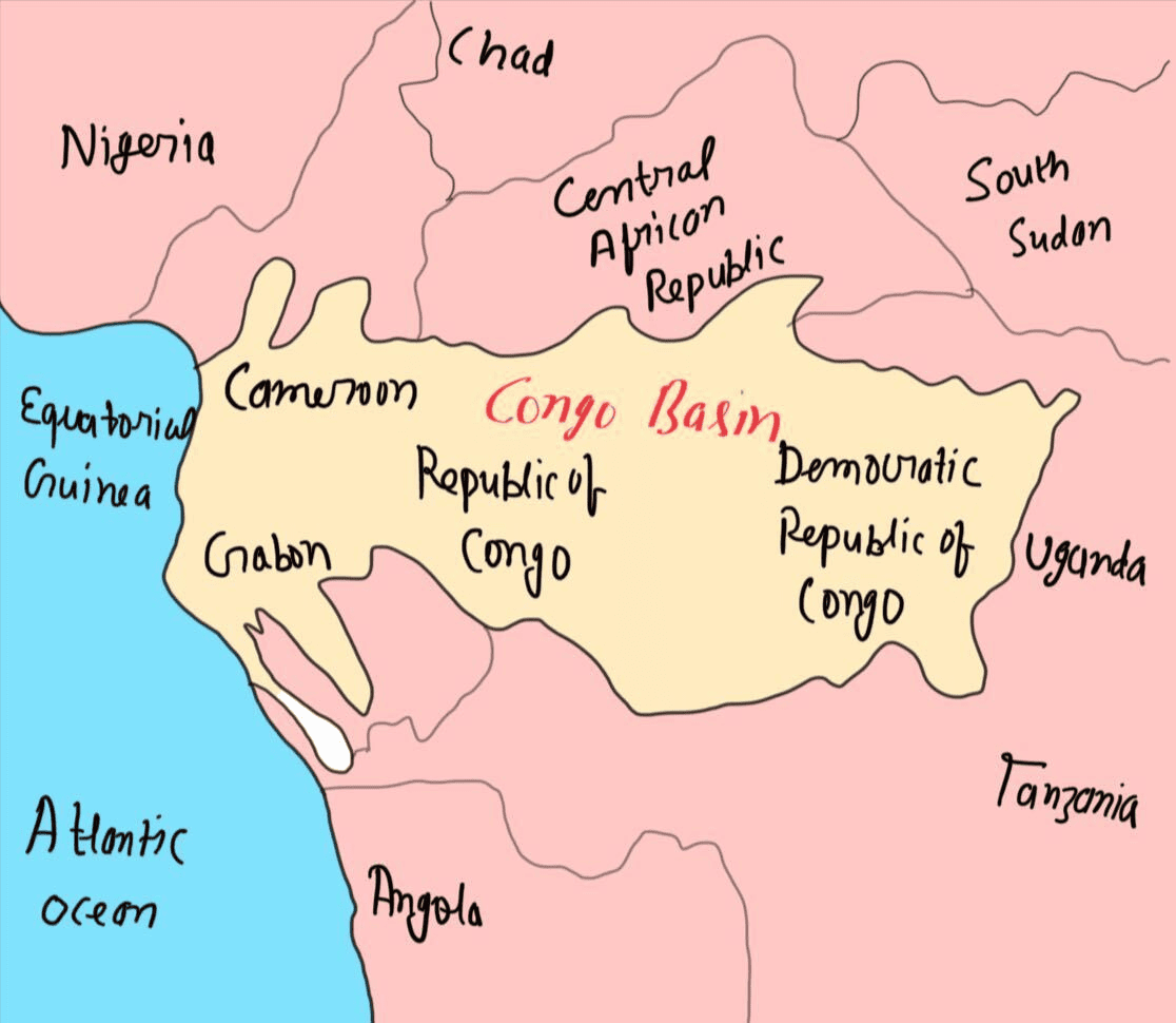
Which one of the following is a part of the Congo Basin?

A. Cameroon

B. Nigeria

C. South Sudan

D. Uganda

Answer: A

Explanation

  • The Congo Basin is a vast region in Central Africa that encompasses several countries. It is the sedimentary basin of the Congo River and is located in a region known as West Equatorial Africa. 

Congo

  • The Congo Basin spans across mainly six countries Cameroon, Central African Republic, Democratic Republic of the Congo, Republic of the Congo, Equatorial Guinea, and Gabon.

Thus, Option A is correct.


QUESTION 7

MediumIndian GeographyPrelims 2023

Consider the following trees:

  1. Jackfruit (Artocarpus heterophyllus)
  2. Mahua (Madhuca indica)
  3. Teak (Tectona grandis)

How many of the above are deciduous trees?

A. Only one

B. Only two

C. All three

D. None

Answer: B

Explanation

  • Option 1 is incorrect:  Jackfruit, (Artocarpus heterophyllus) is a tropical evergreen tree (family Moraceae) native to tropical Asia and widely grown throughout the wetland tropics for its large fruits and durable wood. The greenish unripe fruit is cooked as a vegetable, and the brown ripened fruit is eaten fresh for the sweetly acidic but insipid pulp surrounding the seeds. 

  • Option 2 and 3 are correct:  The Moist deciduous forests are more pronounced in the regions which record rainfall between 100-200 cm. These forests are found in the northeastern states along the foothills of Himalayas, eastern slopes of the Western Ghats and Odisha. Teak, sal, shisham, hurra, mahua, amla, semul, kusum, and sandalwood etc. are the main species of these forests.

Type of trees


QUESTION 8

MediumWorld GeographyPrelims 2023

About three-fourths of world's cobalt, a metal required for the manufacture of batteries for electric motor vehicles, is produced by

A. Argentina

B. Botswana

C. The Democratic Republic of the Congo

D. Kazakhstan

Answer: C

Explanation

  • Cobalt has emerged as a vital ingredient of the shift to a lower-carbon energy system, but reserves of the metal are concentrated heavily in just a single country.

  • The Democratic Republic of Congo (DRC) is home to half of the world's known resources and currently accounts for around 70% of global production. 

  • The metals used in electronic goods, particularly the rechargeable batteries used in electric vehicles and other forms of energy storage means interest in it is growing as the electrification of the global energy system continues to gather pace.

  • Cobalt is used in batteries, superalloys, catalysts, magnets, and pigments for various industries like electronics, aviation, and manufacturing.

  • Democratic Republic of Congo (I), Indonesia (II), Russia (III), Australia (IV), and Madagascar (V) are the top 5 Cobalt-producing countries in the world.

  • Small deposits of Cobalt are known to exist in Odisha & Jharkhand in India.

Cobalt is a rare earth element and has also been classified as a critical mineral by the Government of India.


QUESTION 9

HardIndian GeographyPrelims 2023

Ilmenite and rutile, abundantly available in certain coastal tracts of India, are rich sources of which one of the following?

A. Aluminium

B. Copper

C. Iron

D. Titanium

Answer: D

Explanation

  • Ilmenite (FeTiO3) and Rutile (TiO2) are both minerals that contain high concentrations of titanium. 

  • Titanium is a strong and lightweight metal known for its excellent corrosion resistance and high strength-to-weight ratio. It is widely used in various industries, including aerospace, automotive, medical, and construction. 

  • In India, certain coastal tracts are known for their significant ilmenite and rutile deposits. Hence these minerals are also called beach sand minerals. These minerals are commonly found in beach sand deposits and are extracted through beach sand mining operations. The extracted ilmenite and rutile are processed to obtain titanium dioxide (TiO2), which is then further refined to produce metallic titanium. 

  • Beach sand is rich in seven heavy minerals—ilmenite, leucoxene, rutile, zircon, sillimanite, garnet and monazite.


QUESTION 10

HardIndian GeographyPrelims 2023

Consider the following statements:

  1. Jhelum River passes through Wular Lake.
  2. Krishna River directly feeds Kolleru Lake
  3. Meandering of Gandak River formed Kanwar Lake.

How many of the statements given above are correct?

A. Only one

B. Only two

C. All three

D. None

Answer: A

Explanation

  • Statement 1 is correct: The Jhelum, an important tributary of the Indus, rises from a spring at Verinag situated at the foot of the Pir Panjal in the southeastern part of the valley of Kashmir. It flows through Srinagar and the Wular Lake before entering Pakistan through a deep narrow gorge. It joins the Chenab near Jhang in Pakistan.

  • Statement 2 is incorrect: The Kolleru lake serves as a natural flood-balancing reservoir for two rivers. The lake is fed directly by water from the seasonal Budameru and Tammileru streams. It is connected to the Krishna (but not directly feeds) and Godavari systems by over 68 inflowing drains and channels.

  • Statement 3 is incorrect: Once a haven for migratory birds, the Kanwar Lake in Bihar, Asia’s largest freshwater oxbow lake, is today a dying wetland ecosystem. It is a residual oxbow lake, formed due to the meandering of Budi Gandak river, a tributary of Ganga and not the Gandak river.


QUESTION 11

MediumIndian GeographyPrelims 2023

Consider the following statements: Statement-I: India, despite having uranium deposits, depends on coal for most of its electricity production. Statement-II: Uranium, enriched to the extent of at least 60% is required for the production of electricity.

Which one of the following is correct in respect of the above statements?

A. Both Statement-I and Statement-II are correct and Statement-II is the correct explanation for Statement-I

B. Both Statement-I and Statement-II are correct and Statement-II is not the correct explanation for Statement-I

C. Statement-I is correct but Statement-II is incorrect

D. Statement-I is incorrect but Statement-II is correct

Answer: C

Explanation

  • Statement I Correct : India has domestic uranium reserves, but they are not enough to meet the country's nuclear power generation needs. Additionally, some nuclear reactors in India use imported uranium. Coal remains the dominant source of electricity production in India, although its share is gradually decreasing. 

Electricity mix

  • The major uranium deposits of the country occur in geological basins of the Singhbhum shear zone (Jharkhand), Cuddapah basin (Andhra Pradesh and Telangana), Mahadek basin (Meghalaya), Delhi Supergroup of rocks (Rajasthan) and Bhima basin (Karnataka).

Statement II Incorrect : Nuclear power plants can utilise uranium enriched to varying degrees. India primarily uses Pressurised Heavy Water Reactors (PHWRs) that can function efficiently with low-enriched uranium (around 2-5% enrichment).


QUESTION 12

MediumIndian GeographyPrelims 2023

Consider the following statements:

  1. Amarkantak Hills are at the confluence of Vindhya and Sahyadri Ranges.
  2. Biligirirangan Hills constitute the easternmost part of Satpura Range.
  3. Seshachalam Hills Constitute the southernmost part of Western Ghats.

How many of the statements given above the correct?

A. Only one

B. Only two

C. All three

D. None

Answer: D

Explanation

  • Statement 1 is incorrect: Amarkantak (NLK Amarakaaka) is a pilgrim town in Anuppur, Madhya Pradesh, India. Amarkantak Hills is the meeting point of the Vindhya, Satpura, and Maikal Ranges. It is also the origin of the Narmada, Son, and Johilla Rivers.

  • Statement 2 is incorrect: The Billigirirangan Hills, also known as Biligiriranga Hills or BR Hills, are not a part of the Satpura range. The Biligirirangana Hills or Biligirirangan Hills is a hill range situated in south-western Karnataka, at its border with Tamil Nadu (Erode District) in South India. The area is called Biligiri Ranganatha Swamy Temple Wildlife Sanctuary or simply BRT Wildlife Sanctuary.

  • Statement 3 is incorrect: The Seshachalam Hills, also known as Tirumala Hills, are not a part of the Western Ghats. Seshachalam Hills are hilly ranges part of the Eastern Ghats in southern Andhra Pradesh state, in southeastern India. The Seshachalam hill ranges are predominantly present in Tirupati district of the Rayalaseema region in Andhra Pradesh, India.

Thus, None of the Statements are correct.


QUESTION 13

MediumWorld GeographyPrelims 2023

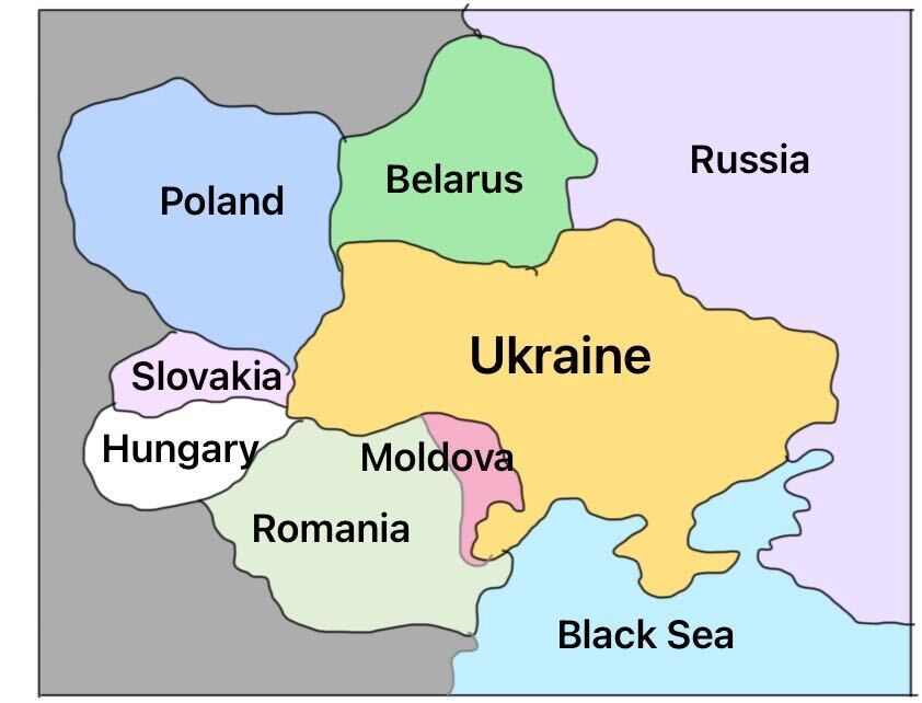
Consider the following countries:

  1. Bulgaria
  2. Czech Republic
  3. Hungary
  4. Latvia
  5. Lithuania
  6. Romania

How many of the above-mentioned countries share a land border with Ukraine?

A. Only two

B. Only three

C. Only four

D. Only five

Answer: A

Explanation

  • Bulgaria does not share a land border with Ukraine. It is located to the south of Romania and is separated from Ukraine by Romania.

  • The Czech Republic is located to the west of Ukraine and does not share a land border with it.

  • Hungary shares a land border with Ukraine to the west.

  • Latvia is located to the north of Ukraine and does not share a land border with it.

  • Lithuania is located to the north of Ukraine and does not share a land border with it.

  • Romania shares a land border with Ukraine to the south.

  • Only two of the above-mentioned countries (Hungary and Romania) share a land border with Ukraine.

Ukraine


QUESTION 14

MediumIndian GeographyPrelims 2023

With reference to coal-based thermal power plants in India, consider the following statements :

  1. None of them uses seawater.
  2. None of them is set up in water-stressed district.
  3. None of them is privately owned.

How many of the above statements are correct?

A. Only one

B. Only two

C. All three

D. None

Answer: D

Explanation

  • Statement 1 is incorrect: The Mundra Thermal Power Plant employs a closed-cycle induced draft circulating cooling water system that utilises seawater. Seawater is drawn from the Gulf of Kutch through robust glass reinforced pipes of significant diameter. In addition, purified seawater from a reverse osmosis plant is utilised by various supplementary systems.

  • Statement 2 is incorrect:  According to recent research by WRI (World Resources Institute), 40 percent of India's thermal power plants are situated in regions experiencing significant water stress. This poses a challenge as these plants rely on water for cooling purposes. The scarcity of water is already causing disruptions in electricity generation in these areas, with 14 out of India's 20 largest thermal utilities having experienced at least one shutdown between 2013 and 2016 due to water shortages.

  • Statement 3 is incorrect:  India has a total of 269 Thermal Power Plants, with 138 of them being owned by the public sector and the remaining 131 owned by the private sector.


QUESTION 15

EasyPhysical GeographyPrelims 2023

Consider the following statements:

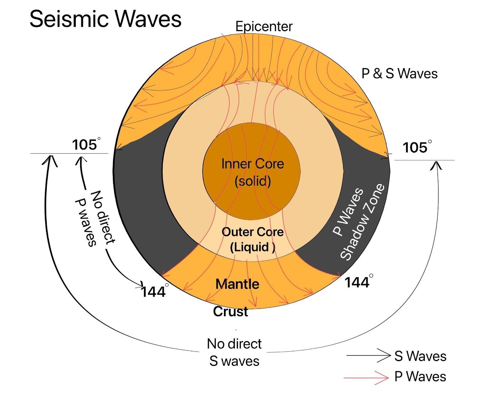
  1. In a seismograph, P waves are recorded earlier than S waves.
  2. In P waves, the individual particles vibrate to and fro in the direction of wave propagation whereas in S waves, the particles vibrate up and down at right angles to the direction of wave propagation.

Which of the statements given above is/are correct?

A. 1 only

B. 2 only

C. Both 1 and 2

D. Neither 1 nor 2

Answer: C

Explanation

In a seismograph, P wavesare recorded earlier than S waves. This is true because P waves, also known as Primary waves, are the first to be recorded by a seismograph during an earthquake. They are faster and hence, reach the recording instrument before the S waves.

P waves are longitudinal or compressional waves, which means the particles in these waves vibrate in the same direction as the wave propagation. On the other hand, S waves, or Secondary waves, are transverse waves, where the particle motion is perpendicular to the direction of wave propagation. Therefore, both statements are correct.

Seismic Waves

Share