UPSC Prelims 2021 Analysis
Subject-Wise MCQ Distribution
- Environment & Ecology (18 questions): Consistently a major component due to its relevance in both the Civil Services Examination (CSE) and the Indian Forest Service (IFoS) prelims. Several questions required maps for identifying key environmental regions.
- Indian Polity (18 questions): A high-weightage subject with several assertion-based and conceptual questions.
- Economy (14 questions): Covered major economic policies, fiscal measures, and budget-related aspects.
- Science & Technology (13 questions): Focused on innovations, emerging technologies, and applications in real-world scenarios.
- History (24 questions total):
- Ancient History: 3 questions
- Medieval History: 4 questions
- Modern History: 7 questions
- Art & Culture: 10 questions, including match the following-based formats.
- Geography (9 questions total):
- Indian Geography: 5 questions
- Physical Geography: 2 questions
- World Geography: 2 questions
- Social Issues & Schemes (2 questions): Covered important government initiatives and their societal impact.
- International Relations (2 questions): Focused on international organizations and global events, underlining the importance of reading newspapers and NCERT basics.

Difficulty Analysis
- Easy (35 questions): Required fundamental NCERT knowledge and factual recall.
- Medium (38 questions): Needed deeper analytical abilities and elimination techniques.
- Hard (27 questions): Demanded conceptual clarity, particularly in assertion-reasoning and interdisciplinary topics.

Variations in Question Framing
- Multi-Statement Based Questions: A large portion of the paper tested analytical abilities by requiring candidates to determine the correctness of multiple statements.
- Direct Questions: Some questions were fact-based, relying on static knowledge from textbooks and previous UPSC question papers.
- Application-Based Questions: Many questions in Economy and Science & Technology assessed real-world applications of concepts.
- Match the Following: Commonly seen in Art & Culture, Geography, and Environment sections.

Static vs Current Affairs Distribution
- Static Content: Dominated the paper with key subjects like History, Polity, Geography, and Economy forming the foundation.
- Current Affairs (22 questions): Focused on recent government policies, budget highlights, and global events influencing India.
Key Learnings for Future Preparation
- Master Static & Current Affairs: A blend of both is necessary, especially for high-weightage subjects like Polity, Economy, and Environment.
- Strengthen Analytical Abilities: Many questions required assertion-reasoning, elimination techniques, and multi-statement evaluation.
- Focus on Budget & Economic Policies: Economy and budget-related topics remain crucial for UPSC preparation.
- Practice Match the Following & Statement-Based MCQs: These were heavily featured in Geography, History, and Environment sections.
- Utilize Maps for Geography & Environment: Many UPSC last year question papers have included map-based questions, making this an essential skill.
Subject-Wise Answer Key
QUESTION 1
GS
Easy
World Geography
Prelims 2021
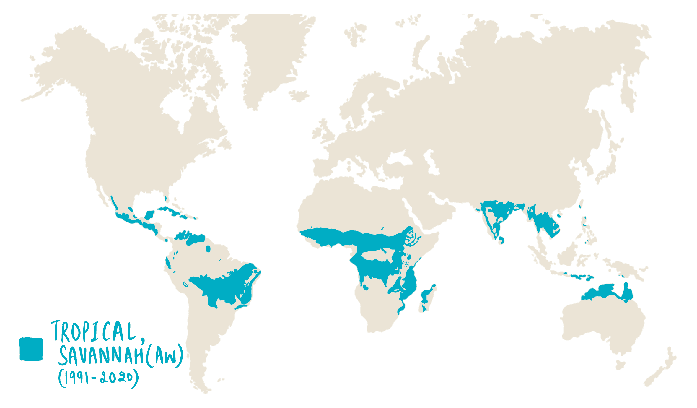
The vegetation of savannah consists of grassland with scattered small trees, but extensive areas have no trees. The forest development in such areas is generally kept in check by one or more or a combination of some conditions. Which of the following are such conditions?
- Burrowing animals and termites
- Fire
- Grazing herbivores
- Seasonal rainfall
- Soil properties
Select the correct answer using the codes given below
A. 1 and 2
B. 4 and 5
C. 2, 3 and 4
D. 1, 3 and 5
QUESTION 2
GS
Hard
Indian Geography
Prelims 2021
Consider the following statements:
- Moringa (drumstick tree) is a leguminous evergreen tree.
- Tamarind tree is endemic to South Asia.
- In India, most of the tamarind is collected as minor forest produce.
- India exports tamarind and seeds of moringa.
- Seeds of moringa and tamarind can be used in the production of biofuels.
Which of the statements given above are correct?
A. 1, 2, 4 and 5
B. 3, 4 and 5
C. 1, 3 and 4
D. 1, 2, 3 and 5
QUESTION 3
GS
Medium
Indian Geography
Prelims 2021
With reference to India, Didwana, Kuchaman, Sargol and Khatu are the names of
A. Glaciers
B. Mangrove areas
C. Ramsar sites
D. Saline lakes
QUESTION 4
GS
Medium
Indian Geography
Prelims 2021
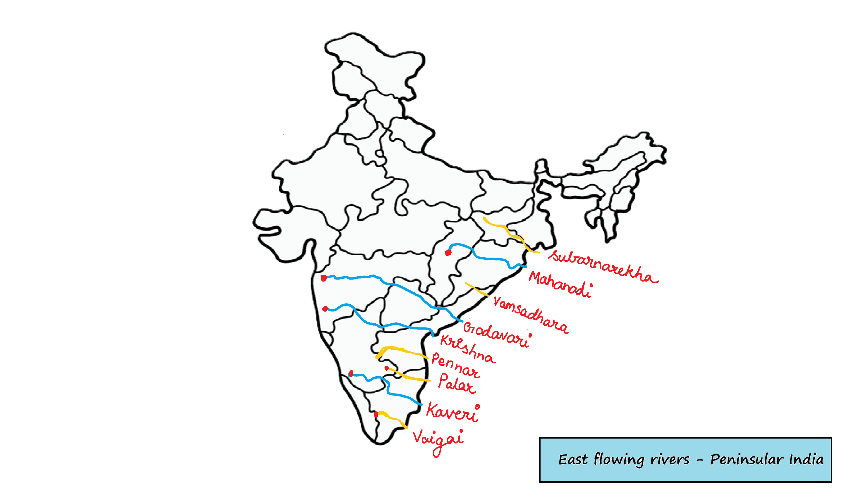
Consider the following rivers:
- Brahamani
- Nagalwali
- Subarnarekha
- Vamsadhara
Which of the above rise from the Eastern Ghats?
A. 1 and 2
B. 2 and 4
C. 3 and 4
D. 1 and 3
QUESTION 5
GS
Medium
Physical Geography
Prelims 2021
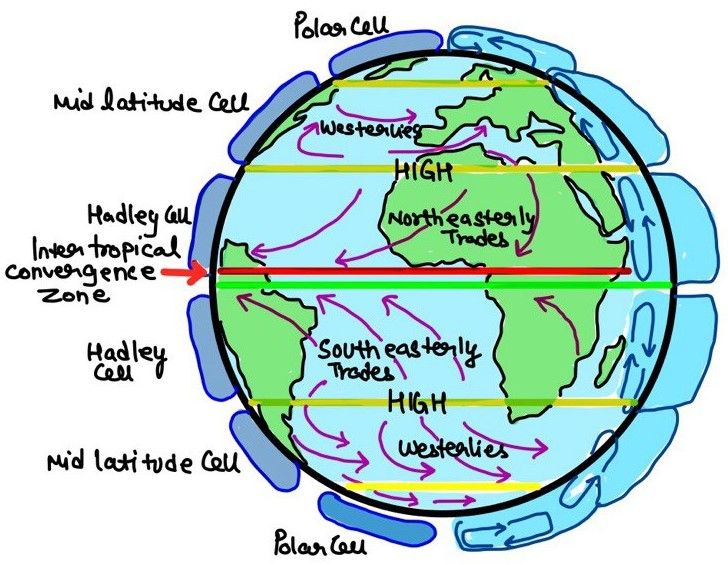
Consider the following statements:
- In the tropical zone, the western sections of the oceans are warmer than the eastern sections owing to the influence of trade winds.
- In the temperate zone, westerlies make the eastern sections of oceans warmer than the western sections.
Which of the statements given above is/are correct?
A. 1 Only
B. 2 Only
C. Both 1 and 2
D. Neither 1 nor 2
QUESTION 6
GS
Hard
Indian Geography
Prelims 2021
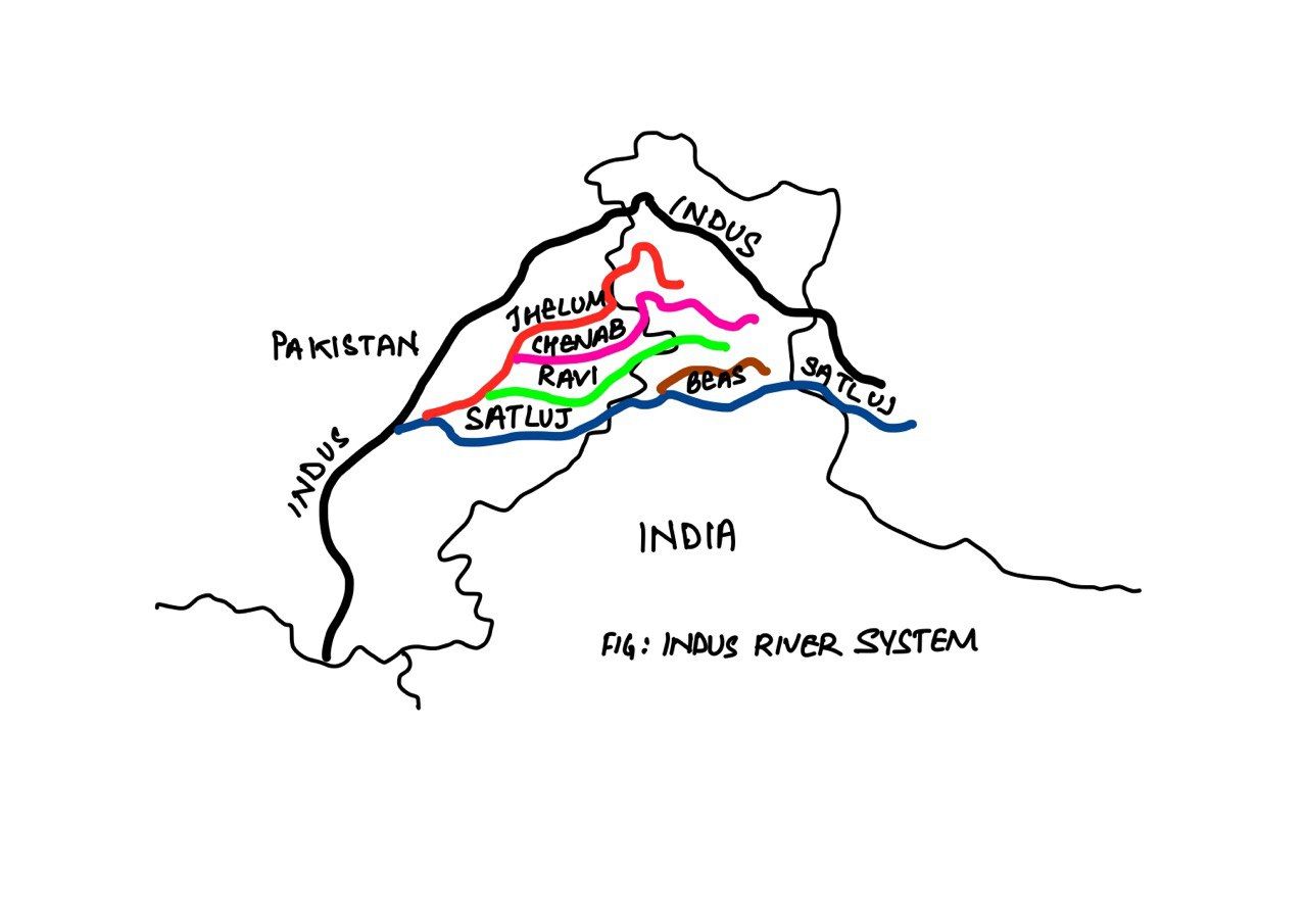
With reference to the Indus river system, of the following four rivers, three of them pour into one of them which joins the Indus direct. Among the following, which one is such river that joins the Indus direct?
A. Chenab
B. Jhelum
C. Ravi
D. Sutlej
QUESTION 7
GS
Easy
World Geography
Prelims 2021
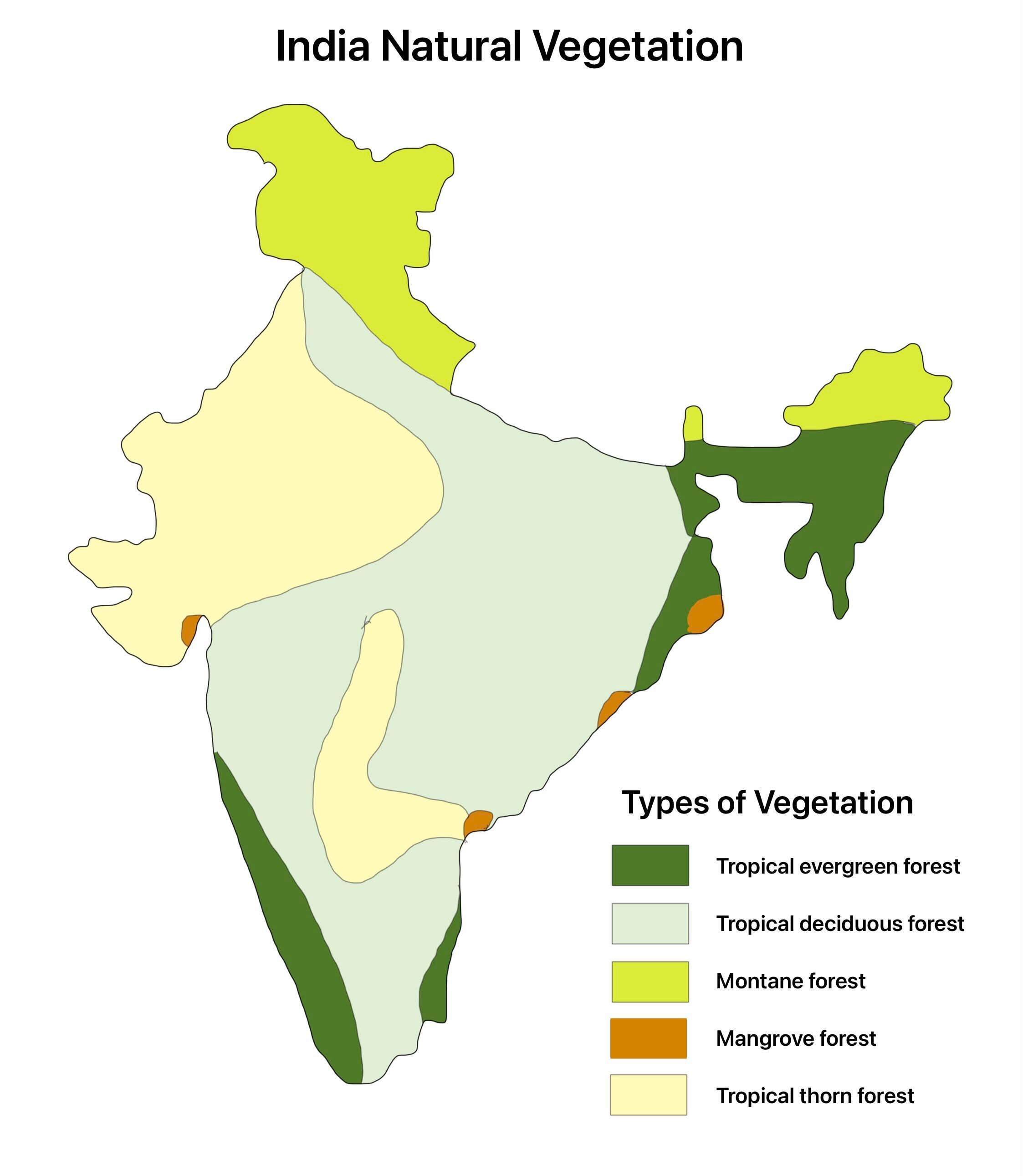
“Leaf litter decomposes faster than in any other biome and as a result the soil surface is often almost bare. Apart from trees, the vegetation is largely composed of plant forms that reach up into the canopy vicariously, by climbing the trees or growing as epiphytes, rooted on the upper branches of trees”. This is the most likely description of
A. coniferous forest
B. dry deciduous forest
C. mangrove forest
D. tropical rain forest
QUESTION 8
GS
Easy
Indian Geography
Prelims 2021
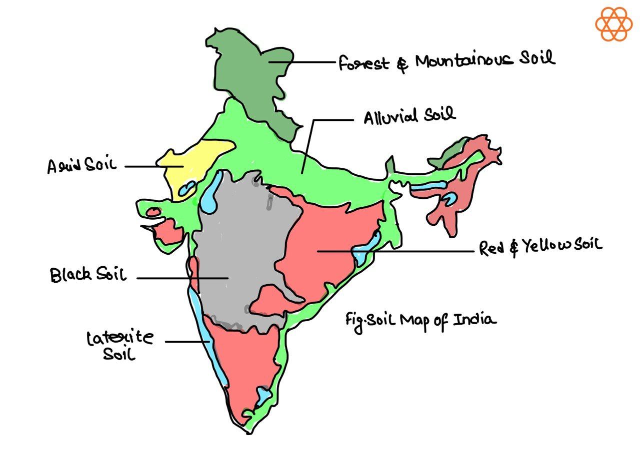
The black cotton soil of India has been formed due to the weathering of
A. brown forest soil
B. fissure volcanic rock
C. granite and schist
D. shale and limestone
QUESTION 9
GS
Medium
Physical Geography
Prelims 2021
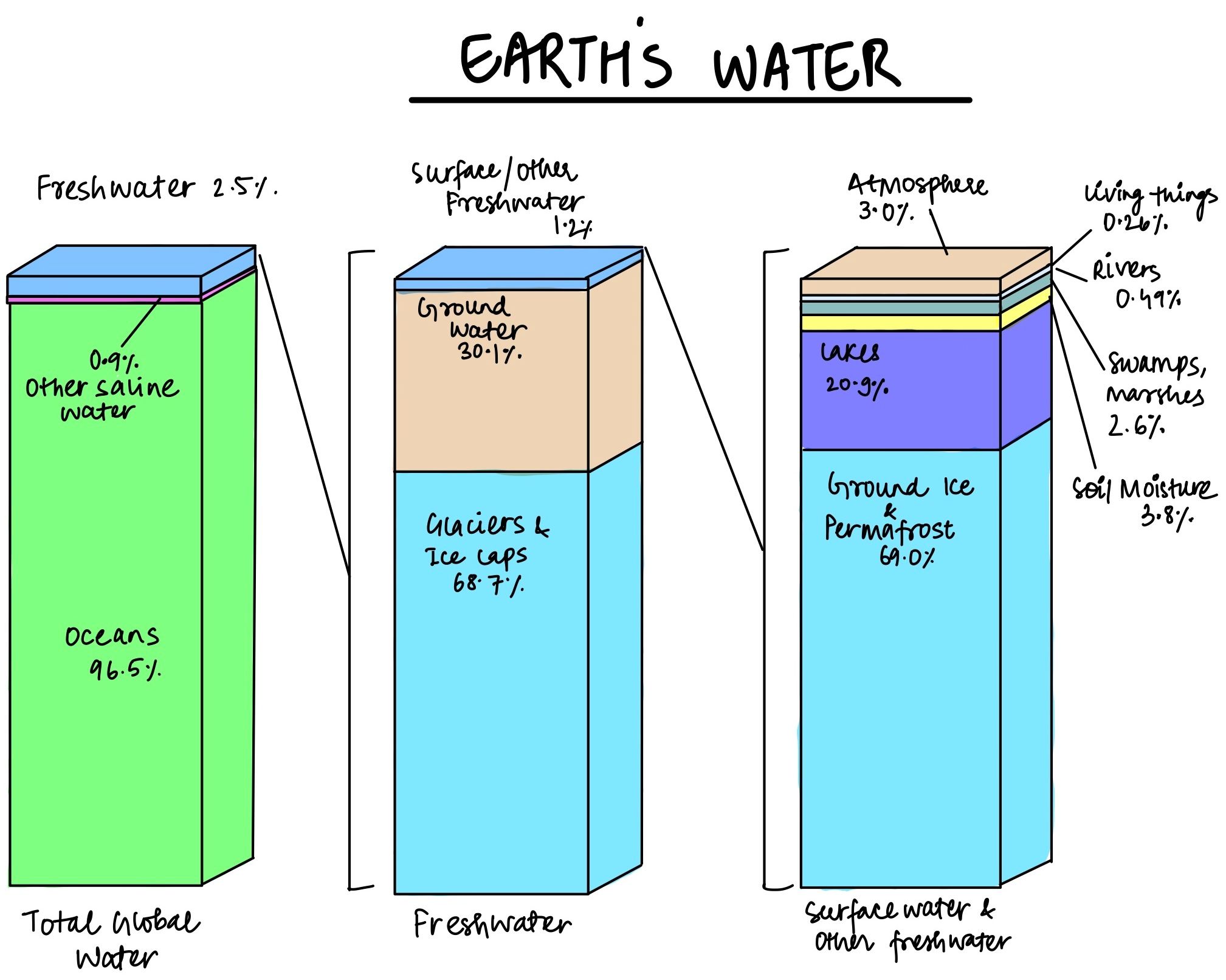
With reference to the water on the planet Earth, consider the following statements:
- The amount of water in the rivers and lakes is more than the amount of groundwater.
- The amount of water in polar ice caps and glaciers is more than the amount of groundwater.
Which of the statements given above is/are correct?
A. 1 Only
B. 2 Only
C. Both 1 and 2
D. Neither 1 nor 2