Analyse & practice 14 years of PYQs to crack UPSCPractice Now

UPSC Prelims 2013 Analysis

Subject-Wise MCQ Distribution

  • Economy (16 Questions): A significant portion covered monetary policies, banking, economic indicators, and core concepts such as inflation and the balance of payments. Many questions followed the assertion-reasoning format, testing both conceptual clarity and practical application.
  • Environment & Ecology (19 Questions): Focused on biodiversity, national parks, environmental pollution, and fundamental ecology concepts. Several questions required an interdisciplinary approach, linking topics to geography, governance, and climate policies.
  • Indian Polity (15 Questions): Included constitutional provisions, policy frameworks, and governmental bodies. The paper tested static knowledge while integrating current affairs-based reasoning, making analytical abilities crucial.
  • Science & Technology (16 Questions): Emphasized fundamental concepts and emerging technologies from biotechnology, space, and AI. Instead of direct current affairs-based questions, many were current affairs-inspired, requiring an understanding of recent developments and their applications.
  • Art & Culture (9 Questions): Had a notable weightage, with a focus on Buddhism & Jainism, the Bhakti movement, architecture, and performing arts. Many questions followed the match the following format, requiring factual knowledge and conceptual linkages.
  • History (8 Questions): Covered Ancient History (2) and Modern History (6), with no Medieval History questionsModern History questions were relatively easy to medium in difficulty, making them scoring opportunities for well-prepared candidates.
  • Geography (13 Questions): Included Physical Geography (5), Indian Geography (5), and World Geography (3). A strong emphasis was placed on conceptual understanding, with several questions integrating maps and geophysical phenomena.
  • Social Issues & Government Schemes (4 Questions): Covered welfare schemes, social development programs, and demographic trends. Many were elimination-based, requiring a clear understanding of policy frameworks.
  • International Relations (0 Questions): Unlike previous years, there were no direct questions on India’s foreign policy or global affairs, marking a deviation in trends.
Prelims 2013
Subject-Wise MCQ Distribution in UPSC Prelims 2013

Difficulty Analysis

  • Easy Questions (39 Questions): Tested foundational knowledge, making them accessible to well-prepared aspirants.
  • Medium Questions (39 Questions): Required analytical skills and an ability to link static concepts with real-world applications, especially in Economy and Science & Technology.
  • Hard Questions (22 Questions): Demanded deep conceptual clarity and critical thinking, particularly in subjects like Economy and Environment.
Prelims 2013
Difficulty Analysis in UPSC Prelims 2013

Variations in Question Framing

  • Multi-Statement Questions (56%) – A significant portion required critical analysis, logical deduction, and elimination strategies. These were common in Polity, Economy, and Environment, with many questions following the assertion-reasoning format.
  • Direct Questions (44%) – Focused on factual recall, particularly in Science & Technology and History. These were relatively easier for candidates with strong static knowledge.
Prelims 2013
Variations in Question Framing in UPSC Prelims 2013

Current Affairs vs. Static Questions

  • Current Affairs-Based Questions (14%) – While fewer in number, many static questions were inspired by current events, requiring candidates to apply their knowledge in real-world contexts.
  • Static Knowledge-Based Questions (86%) – The majority of the paper focused on core subjects, reaffirming the importance of NCERT-based themes, standard books, and foundational concepts.

Key Learnings for Future Preparation

  • Prioritize Static Subjects: Since 86% of the questions were static, aspirants must focus on NCERTs, standard reference books, and core concepts.
  • Master Multi-Statement Questions: Developing skills to break down statements, eliminate incorrect options, and infer logical conclusions is crucial for improving accuracy.
  • Emphasize Environment & Science & Technology: These subjects had a significant presence, requiring conceptual clarity over rote learning.
  • Strengthen Art & Culture Preparation: With 9 questions, this subject played an important role, emphasizing cultural history and heritage.
  • Approach Current Affairs Selectively: Although current affairs questions were fewer, many were inspired by contemporary issues, highlighting the need for smart, selective preparation instead of exhaustive memorization.
UPSC Prelims 2013 emphasized static subjects, with Economy, Environment, and Polity carrying high weightage. Multi-statement questions dominated, testing analytical skills and elimination techniques. Science & Technology and Art & Culture were significant, requiring conceptual clarity. A strong foundation in NCERTs and core subjects was key to tackling the paper effectively.

QUESTION 1

MediumWorld GeographyPrelims 2013

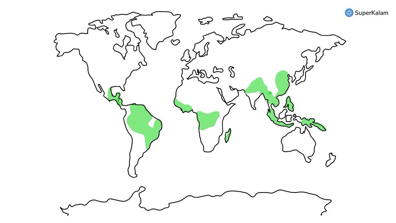
Which of the following is/are unique characteristic/characteristics of equatorial forests?

  1. Presence of tall, closely set trees with crowns forming a continuous canopy
  2. Coexistence of a large number of species
  3. Presence of numerous varieties of epiphytes

Select the correct answer using the code given below:

A. 1 only

B. 2 and 3 only

C. 1 and 3 only

D. 1, 2 and 3

Answer: D

Explanation

Equatorial forests are located within a 5-10 degree band around the equator. They have a hot, humid climate with consistent summer-like weather. These forests have a complex vertical structure, with distinct layers of vegetation and diverse ecosystems.

The tallest trees, known as emergents, dominate the canopy, while the lower layers are home to a variety of plants and animals. Due to high rainfall and a humid climate, these forests provide a suitable environment for the habitat of numerous varieties of fauna and flora. Epiphytes, which are plants that grow on other plants, thrive in tropical equatorial climates because of the above characteristics of equatorial forests.


QUESTION 2

HardWorld GeographyPrelims 2013

Which one of the following pairs is correctly matched? Geographical Feature -- Region

A. Abyssinian Plateau -- Arabia

B. The Atlas Mountains -- North-Western Africa

C. Guiana Highlands -- South-Western Africa

D. Okavango Basin -- Patagonia

Answer: B

Explanation

The Atlas Mountains are a mountain range in the Maghreb . It stretches around 2,500 km (1,600 mi) through Morocco, Algeria and Tunisia . The range's highest peak is Toubkal, with an elevation of 4,167 metres (13,671 ft) in southwestern Morocco. It separates the Mediterranean and Atlantic coastlines from the Sahara Desert .

The Abyssinian plateau is in Ethiopia (in Africa).

Guiana Highland is in South America.

Okavango basin/swamp in Southern part of Africa.


QUESTION 3

MediumPhysical GeographyPrelims 2013

Consider the following:

  1. Electromagnetic radiation
  2. Geothermal energy
  3. Gravitational force
  4. Plate Movements
  5. Rotation of the earth
  6. Revolution of the earth

Which of the above are responsible for bringing dynamic changes on the surface of the earth?

A. 1, 2, 3 and 4 only

B. 1, 3, 5 and 6 only

C. 2, 4, 5 and 6 only

D. 1, 2, 3, 4, 5 and 6

Answer: D

Explanation

All of the listed phenomena (1-6) are responsible for bringing dynamic changes on the surface of the Earth.

Electromagnetic Radiation Sunlight drives weather patterns, influences temperatures, and is crucial for plant life (photosynthesis).

Geothermal Energy Heat from the Earth's core fuels volcanic activity, drives plate tectonics, and shapes landforms.

Gravitational Force The Moon's gravity creates tides in our oceans, influencing coastlines and erosion.

Plate Movements The movement of tectonic plates causes mountain formation, earthquakes, and continental drift, constantly reshaping the Earth's surface.

Rotation of the Earth Earth's rotation creates day and night cycles, affecting weather patterns and influencing wind and ocean currents.

Revolution of the Earth Earth's revolution around the Sun causes seasons, impacting temperatures and weather patterns globally.

These forces act together in a complex interplay, constantly sculpting and reshaping the Earth's surface over vast timescales.


QUESTION 4

HardIndian GeographyPrelims 2013

Which of the following is/are the characteristic/ characteristics of Indian coal?

  1. High ash content
  2. Low sulphur content
  3. The low ash fusion temperature

Select the correct answer using the codes given below.

A. 1 only

B. 1 and 2 only

C. 2 and 3 only

D. 1, 2 and 3

Answer: B

Explanation

The most significant characteristic of Indian coal is its high ash content, which varies from 35 to 45 per cent, compared with that of coal in other parts of the world, which is around 15 per cent.

Besides high ash content, another reason for entrained gasifiers (that operate at higher temperatures than fluidised bed gasifiers), commonly used in IGCC plants abroad, being not suitable for Indian coal has a high ash fusion temperature of about 1,500

However, Indian coal's sulphur content is low, about 0.5 per cent.


QUESTION 5

HardIndian GeographyPrelims 2013

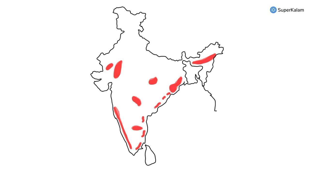
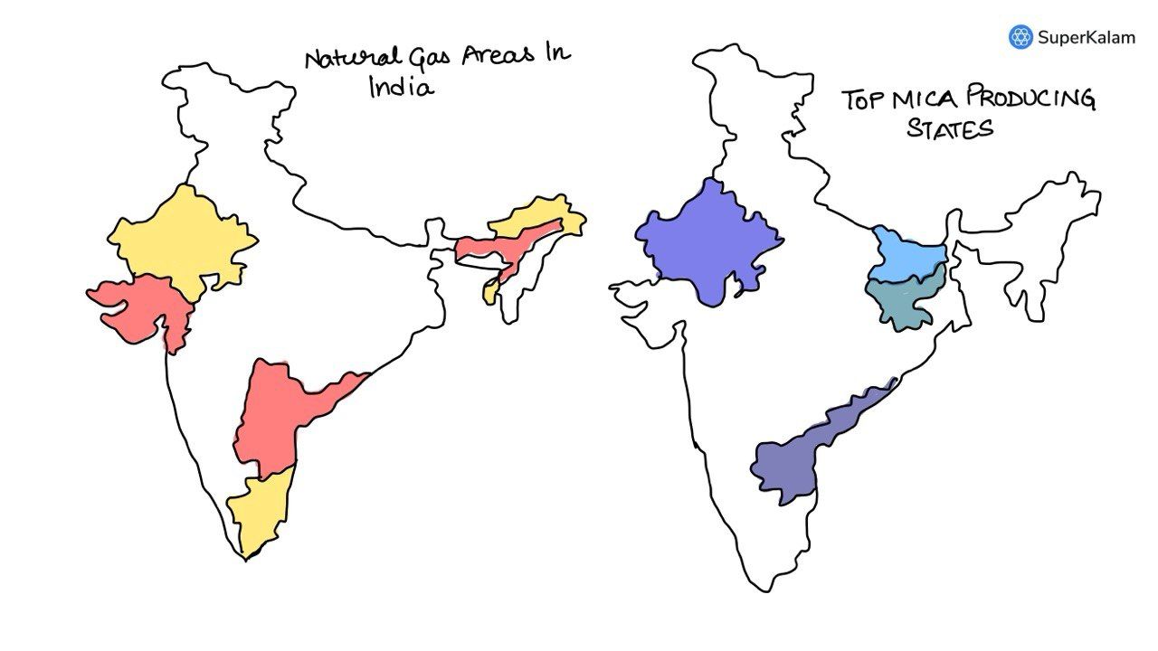
Consider the following statements:

  1. Natural gas occurs in the Gondwana beds.
  2. Mica occurs in abundance in Kodarma.
  3. Dharwars are famous for petroleum.

Which of the statements given above is/are correct?

A. 1 only

B. 2 only

C. 2 and 3 only

D. None

Answer: B

Explanation

KG basin, Assam, Gulf of Khambhat, Cuddalore district of Tamil Nadu, Barmer in Rajasthan etc. are the areas where natural gas can be found.

Kodarma mines in Jharkhand are one of the important mica producing areas.

The Dharwar rocks are rich in iron ore, manganese, lead, zinc, gold, silver etc. Gondwana is famous for coal fields, not natural gas.


QUESTION 6

HardIndian GeographyPrelims 2013

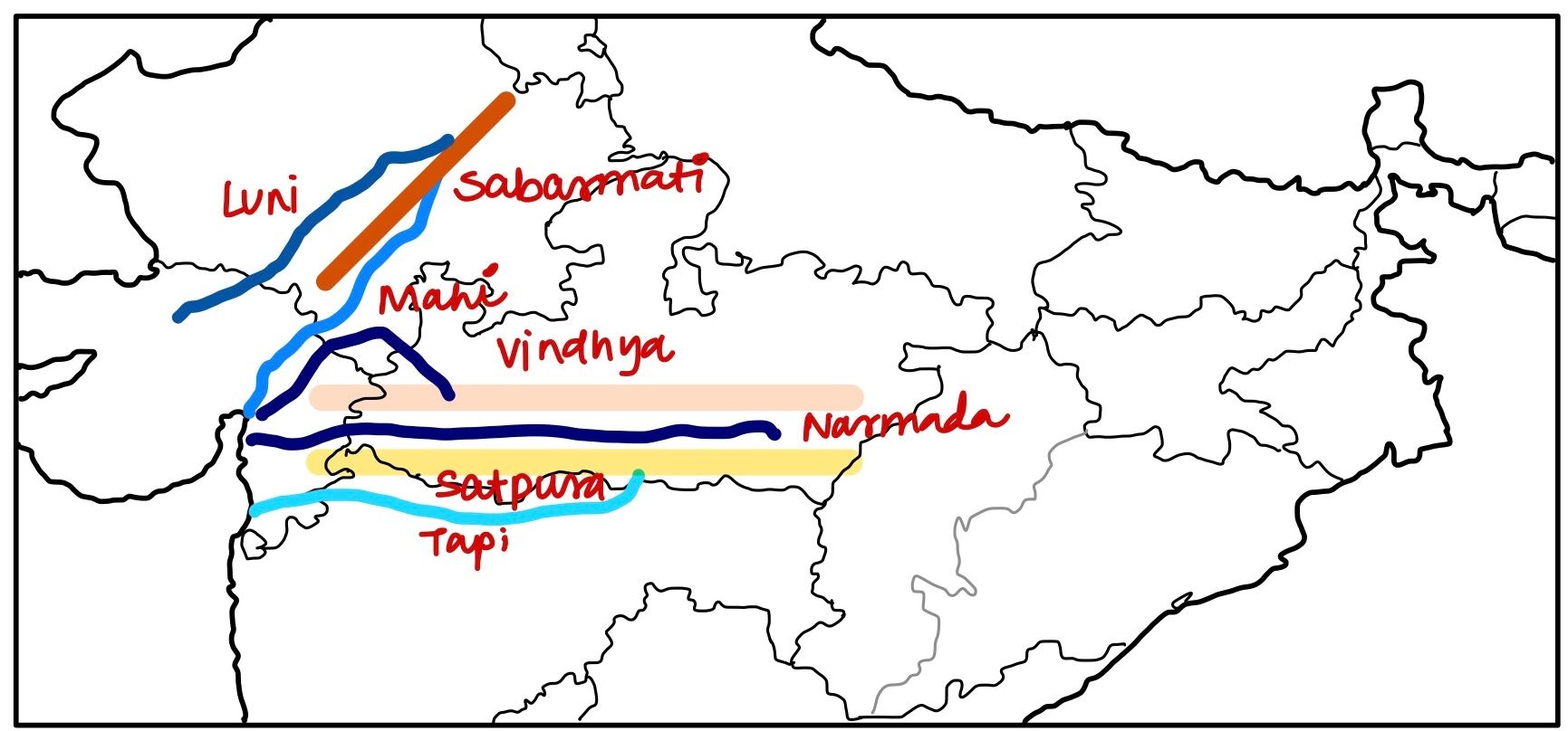
The Narmada river flows to the west, while most other large peninsular rivers flow to the east. Why?

  1. It occupies a linear rift valley.
  2. It flows between the Vindhyas and the Satpuras.
  3. The land slopes to the west from Central India.

Select the correct answer using the codes given below.

A. 1 only

B. 1 and 3 only

C. 2 and 3 only

D. None

Answer: A

Explanation

The Narmada and the Tapi flow through the rift valley.

Statement 3 is wrong as land slopes to the east in the region.

Statement 2 is factually correct however, is not the reason for the rivers to flow to the west.


QUESTION 7

EasyPhysical GeographyPrelims 2013

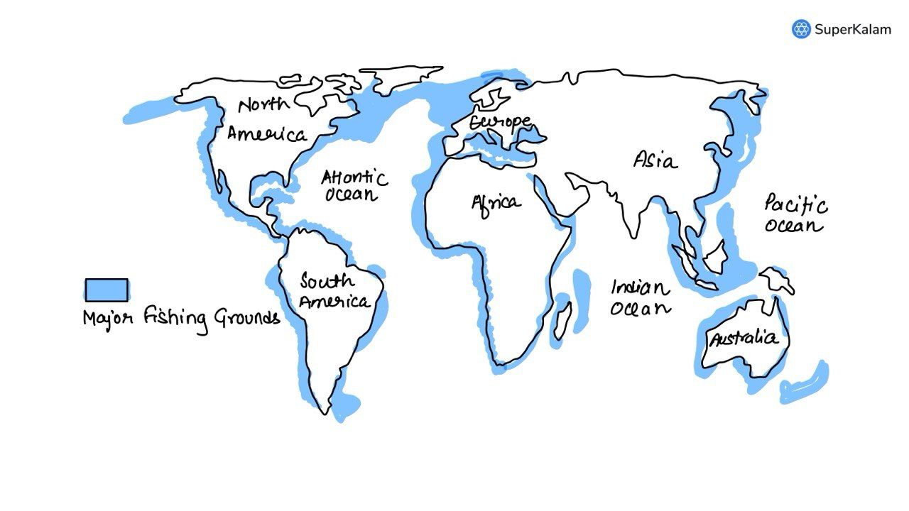
The most important fishing grounds of the world are found in the regions where:

A. Warm and cold atmospheric currents meet

B. Rivers drain out large amounts of fresh water into the sea

C. Warm and cold oceanic currents meet

D. Continental shelf is undulating

Answer: C

Explanation

The most important fishing grounds of the world are found in the regions where warm and cold oceanic currents meet.

Here's why

Nutrient-rich waters When warm and cold currents converge, a process known as upwelling occurs. This upwelling brings nutrient-rich deep ocean water to the surface. These nutrients act like fertilizer for plankton, which forms the base of the marine food chain.

Abundant Marine Life The abundance of plankton attracts a vast array of fish species, making these areas highly productive fishing grounds. Examples include The Grand Banks (Newfoundland) - Labrador Current (cold) meets the Gulf Stream (warm) The Humboldt Current (South America) - cold, nutrient-rich current flowing up the western coast The Canary Current (West Africa) - cold, nutrient-rich current flowing up the western coast


QUESTION 8

EasyPhysical GeographyPrelims 2013

Variations in the length of daytime and nighttime from season to season are due to -

A. The earth’s rotation on its axis

B. Revolution of the earth on a tilted axis

C. Latitudinal position of the place

D. The earth’s revolution around the sun in an elliptical manner

Answer: B

Explanation

The Earth's axis is tilted at an angle of 23.5 degrees relative to its path around the Sun. This tilt means that different parts of the Earth receive direct sunlight for varying lengths of time throughout the year, leading to seasonal changes in day and night length.

Hence the correct answer is (b)


QUESTION 9

EasyPhysical GeographyPrelims 2013

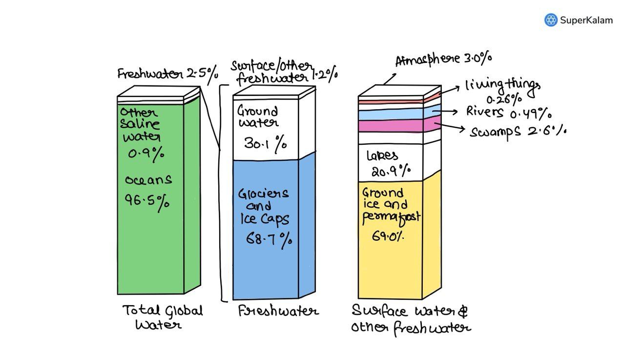
On the planet earth, most of the freshwater exists as ice caps and glaciers. Out of the remaining freshwater, the largest proportion

A. is found in the atmosphere as moisture and clouds

B. is found in freshwater lakes and rivers

C. exists as groundwater

D. exists as soil moisture

Answer: C

Explanation

According to the U.S. Geological Survey, over 68 percent of the freshwater on Earth is found in ice caps and glaciers, and just over 30 percent is found in groundwater.

Only about 0.3 percent of our freshwater is found in the surface water of lakes, rivers, and swamps.


QUESTION 10

EasyIndian GeographyPrelims 2013

Consider the following crops

  1. Cotton
  2. Groundnut
  3. Rice
  4. Wheat

Which of these are Kharif crops?

A. 1 only

B. 1, 2 and 3 only

C. 2 and 3 only

D. 1, 2, 3 and 4

Answer: B

Explanation

The word Kharif is Arabic for autumn, since the season coincides with the beginning of autumn or winter.

Kharif crops also are known as monsoon crops. These are the crops that are cultivated in the monsoon season. The Kharif season differs in every state of the country but is generally from June to September.

These crops are usually sown at the beginning of the monsoon season around June and harvested by September or October. Rice, maize, bajra, ragi, soybean, groundnut, cotton are all Kharif types of crops.


QUESTION 11

HardPhysical GeographyPrelims 2013

The annual range of temperature in the interior of the continents is high as compared to coastal areas. What is/are the reason/reasons?

  1. Thermal difference between land and water
  2. Variation in altitude between continents and oceans
  3. Presence of strong winds in the interior
  4. Heavy rains in the interior as compared to coasts

Select the correct answer using the codes given below.

A. 1 only

B. 1 and 2 only

C. 2 and 3 only

D. 1, 2, 3 and 4

Answer: A

Explanation

The correct answer is 1 only (Thermal difference between land and water).

Here's why Thermal difference Land heats up and cools down much faster than water. This is because water has a higher specific heat capacity, meaning it takes more energy to heat it up and more energy to cool it down. Coastal areas, being influenced by large water bodies, experience a moderating effect on temperature fluctuations. The temperature changes are more gradual throughout the year.

Variation in altitude (2) While altitude can affect temperature (higher altitude generally means cooler temperatures), this is not the primary reason for the difference between continental interiors and coasts. Both continents and oceans have variations in altitude.

Strong winds (3) Winds can play a role in influencing local temperatures, but their presence wouldn't explain the consistent pattern of higher annual ranges seen in continental interiors.

Heavy rainfall (4) Rainfall patterns can affect temperature to some extent, but coastal areas often receive more rainfall compared to continental interiors. This wouldn't explain the higher annual range observed inland.


QUESTION 12

HardWorld GeographyPrelims 2013

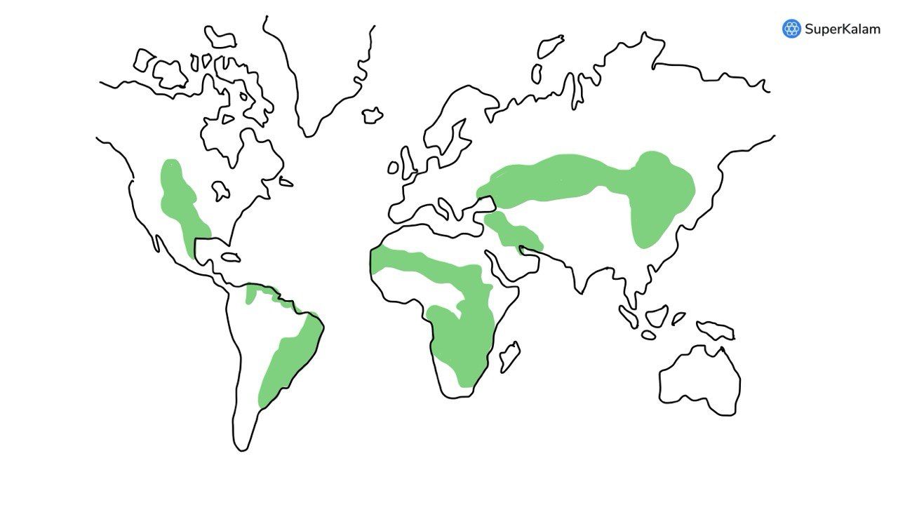
“Climate is extreme, rainfall is scanty and the people used to be nomadic herders.” The above statement best describes which of the following regions?

A. African Savannah

B. North American Prairie

C. Siberian Tundra

D. Central Asian Steppe

Answer: D

Explanation

Steppes are usually characterized by a semi-arid or continental climate. Extremes can be recorded in the summer of up to 45 C (113 F) and in winter, 55 C (67 F). Besides this huge difference between summer and winter, the differences between day and night are also very great.

African Savannah & North American Prairie These regions have more rainfall and varied landscapes compared to the Steppe. Nomadic herding existed, but wasn't the sole way of life.

Siberian Tundra Colder, less rain, permafrost. Not ideal for grazing animals. Nomadic herding is less prevalent.

Therefore, the Central Asian Steppe, with its extreme climate, limited rainfall, and historical dependence on nomadic herding, best fits the description in the statement.


QUESTION 13

EasyIndian GeographyPrelims 2013

Which of the following statements regarding laterite soils of India are correct?

  1. They are generally red in colour.
  2. They are rich in nitrogen and potash.
  3. They are well-developed in Rajasthan and UP.
  4. Tapioca and cashew nuts grow well on these soils.

Select the correct answer using the codes given below.

A. 1 only

B. 1 and 2 only

C. 1 and 4 only

D. 1, 2, 3 and 4

Answer: C

Explanation

Laterite is soil and rock type rich in iron and aluminium but poor in nitrogen, potash, potassium, lime and organic matter and is commonly considered to have formed in hot and wet tropical areas.

  • Nearly all laterites are of rusty-red colouration, because of high iron oxide content.
  • They develop by intensive and prolonged weathering of the underlying parent rock.
  • Tropical weathering (alteration) is a prolonged process of chemical weathering which produces a wide variety in the thickness, grade, chemistry and ore mineralogy of the resulting soils.
  • The majority of the land area containing laterites is between the tropics of Cancer and Capricorn.
  • Laterite soil commonly found in areas of high altitude and heavy rainfall in Karnataka, TN, MP, Bihar, Orissa, Assam, and Meghalaya.
  • Plants like Cashew grow well along with Tapioca in this type of soil.
Share