The recent cyclone on the east coast of India was called “Phailin”. How are the tropical cyclones named across the world? Elaborate.
The recent cyclone on the east coast of India was called “Phailin”. How are the tropical cyclones named across the world? Elaborate.
The naming of tropical cyclones follows a systematic global framework coordinated by international meteorological organizations to ensure effective disaster communication and preparedness.
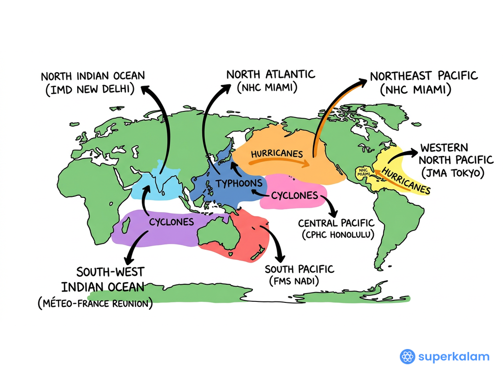
World Map of Tropical Cyclone Basins
Global Cyclone Naming Framework
- World Meteorological Organization (WMO) coordinates the international naming system through Regional Specialized Meteorological Centres (RSMCs) across different ocean basins
- Each RSMC maintains rotating lists of pre-approved names used sequentially for tropical cyclones in their designated regions
- Names are selected to be short, easily pronounceable, and culturally neutral to facilitate clear communication during emergencies
- Gender-balanced naming is maintained with alternating male and female names in most regions
- Names causing extensive damage are permanently retired from future use (Example: Hurricane Katrina, Cyclone Nargis)
Regional Naming Systems Across Ocean Basins
(SK Map: Global Cyclone Naming Regions - showing different ocean basins and their respective naming authorities)
| Ocean Basin | Naming Authority | Contributing Countries/Regions | Total Names |
|---|---|---|---|
| North Indian Ocean | IMD (RSMC New Delhi) | 8 countries (India, Bangladesh, Myanmar, Maldives, Oman, Pakistan, Sri Lanka, Thailand) | 104 names |
| North Atlantic | National Hurricane Center (USA) | Single authority using alphabetical lists | 21 names per season |
| Western Pacific | ESCAP/WMO Typhoon Committee | 14 Asian countries | 140 names |
| South Pacific | Regional committees | Australia, Fiji, New Zealand | Multiple lists |
North Indian Ocean Naming Process
- India Meteorological Department (IMD) serves as RSMC for the North Indian Ocean region since 2020
- Each of the 8 member countries contributes 13 names, creating a comprehensive pool used sequentially
- Recent examples from the list: Cyclone Amphan (2020), Cyclone Yaas (2021), Cyclone Mandous (2022)
- Names reflect regional linguistic diversity while maintaining international pronunciation standards
- Phailin (2013) was contributed by Thailand, demonstrating the multilateral nature of the system
Benefits and Significance
- Enables simultaneous tracking of multiple storms without confusion
- Facilitates rapid communication between meteorological centers, disaster management agencies, and media
- Promotes regional cooperation in disaster preparedness and response coordination
- Supports public awareness campaigns and evacuation planning through memorable storm identification
This systematic approach has significantly improved early warning systems and disaster response mechanisms. The success is evident in recent cyclones like Cyclone Fani (2019), where coordinated naming and communication helped evacuate over 1.2 million people, minimizing casualties despite the storm's intensity.
Answer Length
Model answers may exceed the word limit for better clarity and depth. Use them as a guide, but always frame your final answer within the exam’s prescribed limit.
Evaluate this PYQ now
Write your answer & evaluate in just 60 seconds




500+ students evaluated
Model Answers from
- 2013Indian Geography10 MarksView Answer
It is said that India has substantial reserves of shale oil and gas, which can feed the needs of the country for a quarter century. However, tapping the resources doesn’t appear to be high on the agenda. Discuss critically the availability and issues involved.
- 2013Indian Geography10 MarksView Answer
With the growing scarcity of fossil fuels, atomic energy is gaining more and more significance in India. Discuss the availability of raw materials required for the generation of atomic energy in India and the world.
- 2013Indian Geography5 MarksView Answer
Analyze the factors for the highly decentralized cotton textile industry in India.
- 2013Indian Geography5 MarksView Answer
Do you agree that there is a growing trend of opening new sugar mills in the Southern states of India? Discuss with justification.
- 2013Indian Geography5 MarksView Answer
There is no formation of deltas by rivers of the Western Ghats. Why?
- 2013Indian Geography5 MarksView Answer
Bring out the causes for more frequent landslides in the Himalayas than in the Western Ghats.
Model Answers by Subject


Crack UPSC with your
Personal AI Mentor
An AI-powered ecosystem to learn, practice, and evaluate with discipline