There is no formation of deltas by rivers of the Western Ghats. Why?
There is no formation of deltas by rivers of the Western Ghats. Why?
Rivers of the Western Ghats do not form deltas due to their unique geographical setting and hydrological characteristics. This phenomenon results from distinct physical factors that prevent sediment accumulation at river mouths.
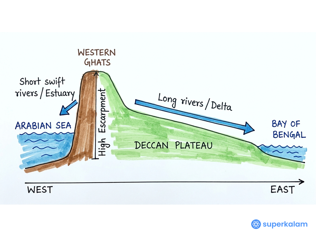
Peninsular India West to East Cross Section
Topographical Constraints
- Steep gradient: Western Ghats create high-velocity rivers with strong erosional power, carrying sediments directly to the sea without deposition
- Short river length: Rivers like Narmada (1,312 km) and Tapti (724 km) have limited sediment-carrying capacity compared to east-flowing rivers
- Narrow coastal plains: The Konkan and Malabar coasts provide insufficient space for delta formation
- Rocky coastline: Hard rock formations prevent natural sediment spreading and accumulation
- High sea cliffs: Vertical coastal relief restricts horizontal sediment deposition
Marine Environment Factors
- Deep Arabian Sea: Ocean depths exceeding 3,000 meters near the coast allow sediments to disperse rapidly into deep waters
- Strong tidal currents: Arabian Sea's powerful currents continuously transport sediments away from river mouths
- High wave energy: Monsoon-driven waves with heights up to 4-6 meters prevent sediment accumulation
- Submarine canyons: Underwater valleys like those off Mumbai facilitate direct sediment transport to abyssal depths
- Limited continental shelf: Narrow shelf width (20-50 km) compared to east coast (120-200 km) restricts delta formation space
Hydrological Characteristics
- Seasonal flow regime: Rivers experience extreme seasonal variations, with 80% discharge during monsoons
- Flash flood nature: Rapid runoff during monsoons creates high-energy conditions unsuitable for deposition
- Limited sediment load: Crystalline rocks of Western Ghats produce less sediment compared to alluvial plains
- Estuarine conditions: Rivers form estuaries and backwaters (like Kerala's Vembanad) instead of deltas
- Rift valley formation: Rivers like Narmada flow through fault-controlled valleys, creating different depositional patterns
This unique combination explains why Western Ghat rivers create distinctive coastal features like the Kerala backwaters and Konkan estuaries, demonstrating India's diverse fluvial geomorphology.
Answer Length
Model answers may exceed the word limit for better clarity and depth. Use them as a guide, but always frame your final answer within the exam’s prescribed limit.
In just 60 sec
Evaluate your handwritten answer
- Get detailed feedback
- Model Answer after evaluation
Model Answers by Subject
Crack UPSC with your
Personal AI Mentor
An AI-powered ecosystem to learn, practice, and evaluate with discipline

