Discuss the distribution and density of population in the Ganga River Basin with special reference to land, soil and water resources.
Discuss the distribution and density of population in the Ganga River Basin with special reference to land, soil and water resources.
The Ganga River Basin sustains over 600 million people, making it the world's most densely populated river basin due to its unique convergence of land, soil, and water resources.
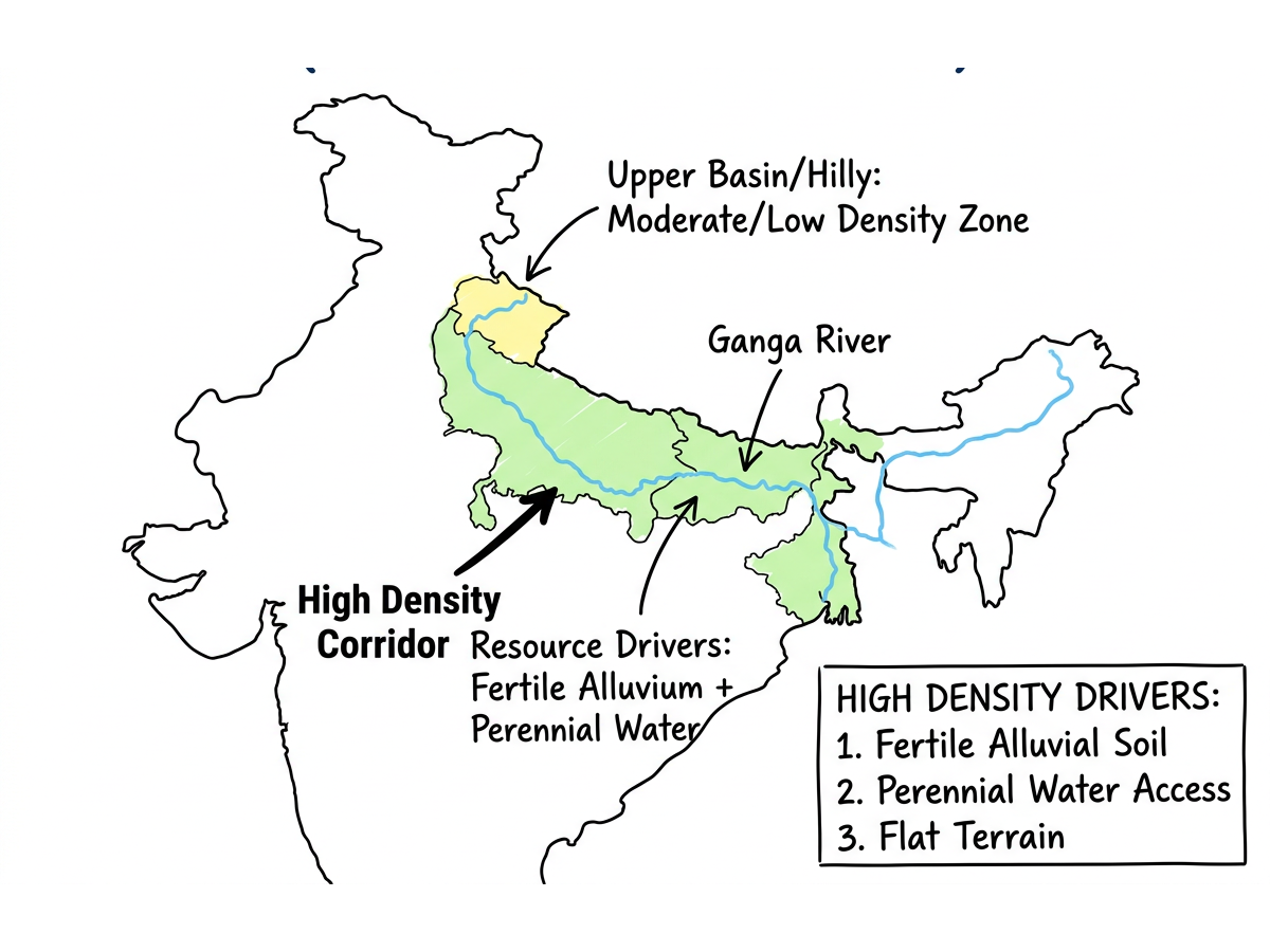
Ganga River Basin Population Density Map
Spatial Distribution and Density Patterns
- The Upper Basin shows sparse density (150–300 persons/km²) as rugged Uttarakhand terrain restricts large-scale human habitation.
- The Middle Basin supports extreme density (800–1,200 persons/km²) where the flat topography of UP and Bihar enables intensive agriculture.
- The Lower Basin records the highest density (>1,000 persons/km²), driven by highly fertile Bengal deltaic plains and megacities like Kolkata.
- Population distribution follows a distinctly linear pattern along the Ganga and Yamuna, evolving historically around navigation routes and water access.
Impact of Land Resources on Population
- A 2026 Scientific Reports study notes that basin settlements have expanded by 270%, drastically altering land use at the expense of agriculture.
- Highly cultivated Doab regions dictate rural density, with agriculture supporting over 80% of the rural basin population.
- Severe land fragmentation (holdings under 1.08 hectares) is driving out-migration from rural heartlands to urban nodes like Ghaziabad.
- Rising demographic pressure on land prompted the Supreme Court (2024) to heavily reprimand authorities over illegal encroachments of Patna's floodplains.
- To curb land-use conflicts, the National Green Tribunal (2024) mandated strict 3D-contour mapping to halt illegal urban constructions.
Influence of Soil Characteristics
- Deep alluvial soils, covering 70% of the basin, anchor the massive population by enabling multiple annual cropping cycles.
- Areas dominated by Khadar (newer alluvium) support the densest rural clusters due to their immense natural fertility in eastern UP and Bihar.
- The Ganga River Basin Management Plan 2.0 (2024) warns that intensive farming by dense populations is rapidly depleting Soil Organic Matter, threatening future agricultural carrying capacity.
Role of Water Resources and Emerging Stresses
- While abundant surface water historically enabled demographic booms, the UN Interconnected Disaster Risks Report 2023 warns the basin has crossed its groundwater depletion tipping point.
- Urban water demands are critical; a 2023 study forecasts a 44% drop in Kolkata’s water table by 2025 due to massive over-extraction.
- High population density has introduced Emerging Organic Contaminants into shallow aquifers, posing severe public health risks to rural inhabitants reliant on groundwater.
To balance this immense demographic pressure, policymakers must enforce the "Arth Ganga" sustainable monetization model. By implementing PRS Legislative Research (2025) recommendations on scaling sewage treatment and adopting regenerative agriculture, India can ensure this UN World Restoration Flagship continues to nourish its population safely.
Answer Length
Model answers may exceed the word limit for better clarity and depth. Use them as a guide, but always frame your final answer within the exam’s prescribed limit.
In just 60 sec
Evaluate your handwritten answer
- Get detailed feedback
- Model Answer after evaluation
Model Answers by Subject
Crack UPSC with your
Personal AI Mentor
An AI-powered ecosystem to learn, practice, and evaluate with discipline

