Discuss the geophysical characteristics of Circum- Pacific Zone.
Discuss the geophysical characteristics of Circum- Pacific Zone.
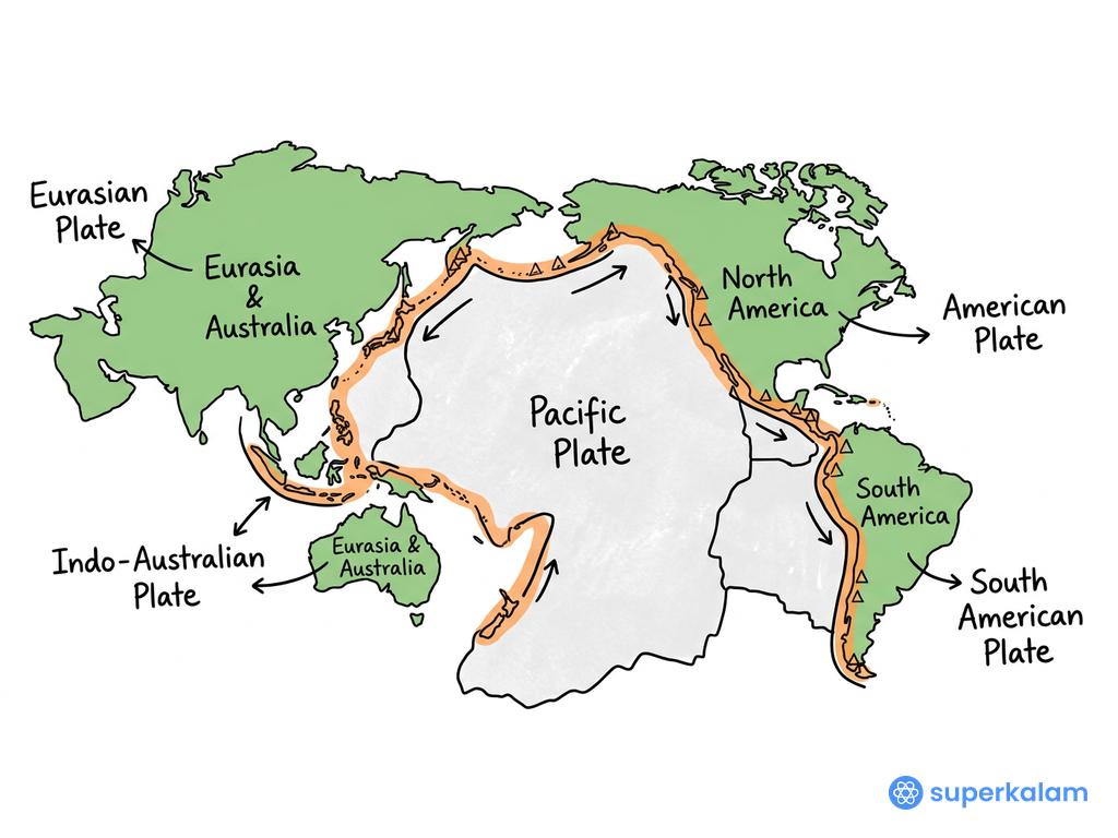
The Circum-Pacific Zone or "Ring of Fire" forms a 40,000 km belt around the Pacific Ocean, representing Earth's most geologically active region with 90% of global earthquakes and 75% of active volcanoes.
Pacific Ring of Fire Map 2020
Tectonic Framework
- Convergent Plate Boundaries: Multiple oceanic plates (Pacific, Nazca, Juan de Fuca) subducting beneath continental plates
- Transform Faults: San Andreas Fault system extending 1,200 km along California coast
- Triple Junctions: Complex intersections like the Mendocino Triple Junction off California
- Subduction Zones: Cascadia, Japan Trench, and Peru-Chile systems creating continuous seismic activity
- Back-Arc Basins: Sea of Japan and Philippine Sea formed by extensional processes
Volcanic Characteristics
- Stratovolcanoes: Dominant volcanic type including Mount Fuji, Mount Rainier, and Cotopaxi
- Volcanic Arcs: Japanese archipelago, Aleutian Islands, and Andes mountain chain
- Calderas: Yellowstone (USA), Toba (Indonesia), and Taupo (New Zealand) supervolcanic systems
- Recent Activity: 2022 Hunga Tonga eruption and ongoing Kilauea eruptions demonstrate continuous volcanism
- Pyroclastic Flows: Regular occurrence along the entire belt affecting millions of people
Bathymetric Features
| Feature | Location | Depth/Height |
|---|---|---|
| Mariana Trench | Western Pacific | 11,034 m (deepest) |
| Peru-Chile Trench | Eastern Pacific | 8,065 m |
| Japan Trench | Northwestern Pacific | 9,000 m |
| Aleutian Trench | North Pacific | 7,679 m |
- Abyssal Plains: Extensive flat seafloor areas interrupted by seamount chains
- Guyots: Flat-topped underwater mountains indicating past sea-level changes
Seismic Activity
- Earthquake Frequency: Over 80% of world's largest earthquakes (magnitude 8+)
- 2024 Statistics: 15,847 earthquakes above magnitude 4.0 recorded
- Tsunami Generation: Pacific Tsunami Warning Center monitors 46 countries
- Recent Events: 2024 Noto Peninsula earthquake (Japan) and Taiwan's Hualien earthquake
- Seismic Gaps: Identified zones with potential for future major earthquakes
Geothermal and Mineral Resources
- Geothermal Energy: Philippines, Indonesia, and New Zealand leading producers
- Mineral Deposits: Copper (Chile), gold (Alaska), and rare earth elements
- Hydrothermal Vents: Unique ecosystems and potential mining sites
- Oil and Gas: Significant reserves in Alaska, California, and Southeast Asia
- Polymetallic Nodules: Deep-sea mining potential in abyssal regions
The Circum-Pacific Zone remains Earth's most dynamic geological laboratory, with the 2025 Pacific Ring of Fire Monitoring Initiative utilizing AI-based early warning systems to protect over 500 million people living within this tectonically active belt.
Answer Length
Model answers may exceed the word limit for better clarity and depth. Use them as a guide, but always frame your final answer within the exam’s prescribed limit.
In just 60 sec
Evaluate your handwritten answer
- Get detailed feedback
- Model Answer after evaluation
Model Answers by Subject
Crack UPSC with your
Personal AI Mentor
An AI-powered ecosystem to learn, practice, and evaluate with discipline

