Why is the Indian Regional Navigational Satellite System (IRNSS) needed? How does it help in navigation?
Why is the Indian Regional Navigational Satellite System (IRNSS) needed? How does it help in navigation?
India's indigenous navigation system IRNSS (Indian Regional Navigation Satellite System), also known as NavIC (Navigation with Indian Constellation), addresses critical strategic and technological requirements while reducing dependency on foreign systems like GPS.
Spatial Diagram of Earth Indian Subcontinent
Strategic Need for IRNSS
- National Security: Ensures uninterrupted navigation services during conflicts when foreign systems like GPS might be denied or degraded by other countries
- Sovereignty: Provides complete control over navigation data and services within Indian territory and surrounding regions
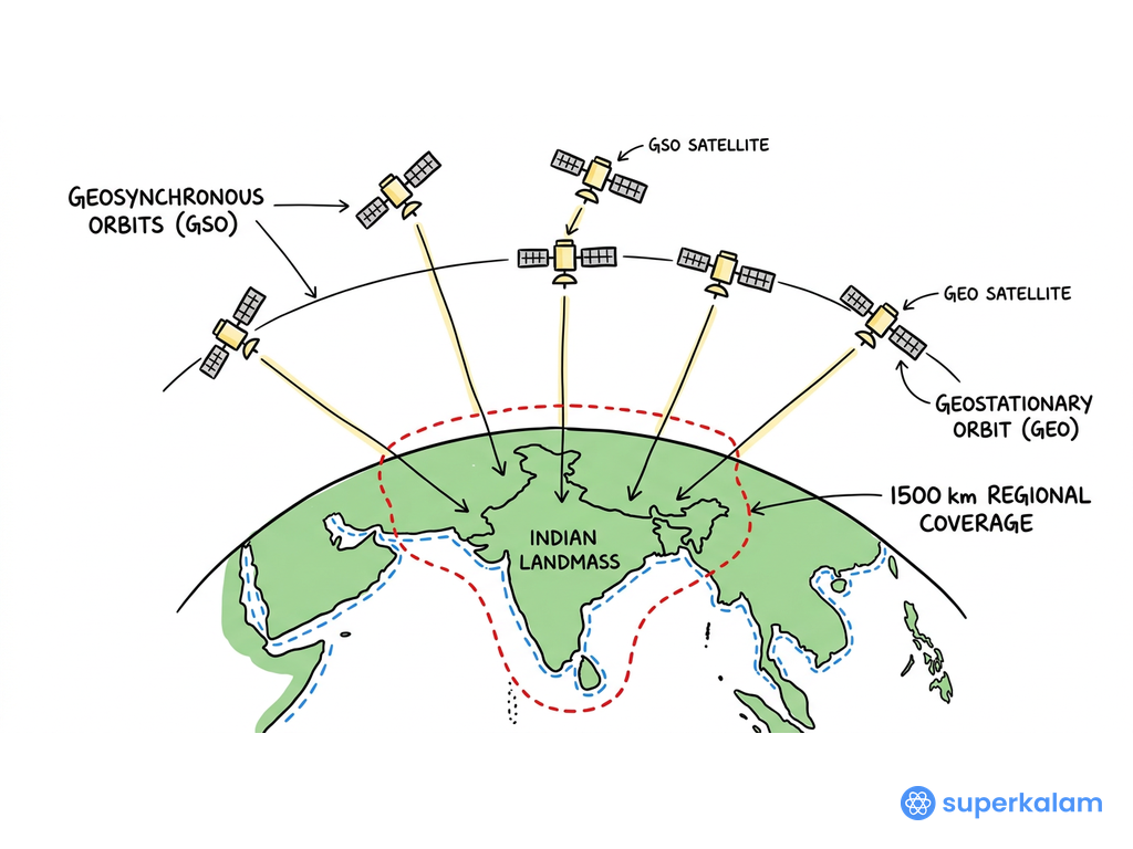
- Strategic Autonomy: Reduces reliance on US-controlled GPS and Russian GLONASS systems, especially after GPS denial during Kargil War (1999)
- Regional Coverage: Extends services up to 1,500 km beyond Indian borders, covering entire South Asian region
- Economic Independence: Eliminates licensing fees and restrictions associated with foreign navigation systems
Navigation Capabilities and Applications
-
Precision and Accuracy:
- Provides positioning accuracy better than 20 meters in primary service area
- Operates on dual frequency bands (L5 and S bands) for enhanced signal quality
- Offers Standard Positioning Service (SPS) for civilian use and Restricted Service (RS) for authorized users
-
Transportation Sector:
- Indian Railways: Integration with Kavach system for automatic train protection and collision avoidance
- Civil Aviation: Supports Required Navigation Performance (RNP) approaches at airports
- Maritime Navigation: Assists coastal and inland waterway navigation with precise positioning
-
Disaster Management:
- Enables real-time tracking during natural disasters like cyclones and earthquakes
- Supports search and rescue operations with accurate location services
- Facilitates emergency response coordination through precise positioning
| Feature | IRNSS/NavIC | GPS |
|---|---|---|
| Coverage | Regional (India + 1500km) | Global |
| Accuracy | <20m (Primary area) | 3-5m |
| Frequency Bands | L5 + S band | L1, L2, L5 |
| Control | Indian | US Military |
With NVS-01 successfully launched in 2023 and plans for NVS-02 in 2024, IRNSS continues strengthening India's position in space-based navigation under the Atmanirbhar Bharat initiative.
Answer Length
Model answers may exceed the word limit for better clarity and depth. Use them as a guide, but always frame your final answer within the exam’s prescribed limit.
In just 60 sec
Evaluate your handwritten answer
- Get detailed feedback
- Model Answer after evaluation
Model Answers by Subject
Crack UPSC with your
Personal AI Mentor
An AI-powered ecosystem to learn, practice, and evaluate with discipline

