Explain the formation of thousands of islands in the Indonesian and Philippines archipelagos.
Explain the formation of thousands of islands in the Indonesian and Philippines archipelagos.
The Indonesian and Philippines archipelagos, containing over 17,000 and 7,640 islands respectively, formed through complex geological processes driven by intense tectonic activity in the Pacific Ring of Fire.
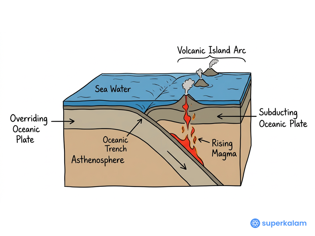
Ocean Plate Subduction Convergence Cross Section
Tectonic Plate Convergence and Formation
- Multiple Plate Interactions: The region lies at the convergence of four major tectonic plates - Pacific Plate, Philippine Sea Plate, Eurasian Plate, and Indo-Australian Plate
- Subduction Zones: Ocean plates subduct beneath continental plates, creating deep trenches like the Philippine Trench (10,540m deep) and Java Trench
- Island Arc Formation: Subduction processes generate magma that rises to form volcanic island arcs through continuous eruptions
- Crustal Uplift: Tectonic compression uplifts seafloor sediments and oceanic crust, creating non-volcanic islands
- Transform Boundaries: Lateral plate movements create fault systems that fragment existing landmasses into smaller islands
Volcanic Activity and Island Building
- Active Volcanism: Indonesia hosts 130 active volcanoes while Philippines has 53 active volcanoes as of 2024
- Volcanic Island Formation: Submarine volcanic eruptions accumulate materials that eventually emerge above sea level
- Shield Volcano Development: Continuous lava flows build broad, shield-shaped islands over hotspots
- Stratovolcano Chains: Explosive eruptions create steep-sided volcanic islands in linear arrangements
- Recent Examples: Mount Ruang eruption (2024) in Indonesia and Mayon Volcano activity (2023) in Philippines continue island modification
Additional Geological Processes
| Process | Mechanism | Examples |
|---|---|---|
| Coral Reef Growth | Accumulation of coral limestone forming atolls and barrier islands | Thousand Islands (Indonesia), Palawan reefs |
| Sea Level Changes | Glacial-interglacial cycles exposing/submerging landmasses | Sunda Shelf exposure during ice ages |
| Erosion and Weathering | Wave action and tropical weathering fragmenting larger landmasses | Fragmentation of Sundaland |
The ongoing tectonic activity ensures continuous island formation, with recent seismic events like the 2024 Mindanao earthquake (magnitude 7.6) demonstrating the dynamic geological processes still shaping these archipelagos through volcanic eruptions, crustal movements, and marine processes.
Answer Length
Model answers may exceed the word limit for better clarity and depth. Use them as a guide, but always frame your final answer within the exam’s prescribed limit.
Evaluate this PYQ now
Write your answer & evaluate in just 60 seconds




500+ students evaluated
Model Answers from
- 2014World Geography10 MarksView Answer
How does India see its place in the economic space of rising natural resource-rich Africa?
- 2014World Geography10 MarksView Answer
Account for the change in the spatial pattern of the Iron and Steel industry in the world.
- 2014World Geography10 MarksView Answer
Tropical cyclones are largely confined to the South China Sea, the Bay of Bengal and the Gulf of Mexico. Why?
Model Answers by Subject


Crack UPSC with your
Personal AI Mentor
An AI-powered ecosystem to learn, practice, and evaluate with discipline