UPSC Prelims 2017 Analysis
Subject wise MCQ distribution
- Polity and Governance: The highest weightage in the exam, with questions focusing on core constitutional concepts like democracy and rights, highlighting a return to traditional themes. Many followed the assertion-reasoning format, testing analytical abilities.
Economy: Heavily current affairs-based, covering topics such as GST, Monetary Policy Committee, and post-1991 reforms. Conceptual clarity was crucial for elimination-based questions.
Geography and Environment: Required conceptual clarity and linkages with current affairs, such as the Indian Ocean Dipole. Many questions incorporated maps for better understanding.
History: Weightage remained consistent, but factual knowledge was essential, especially for match the following and multi-statement questions.
Science & Technology: Mostly news-based, testing awareness of recent developments in biotechnology, AI, and space technology.
Government Schemes & Initiatives: A prominent focus area, covering policies related to education, health, and nutrition. Many questions were framed using the elimination technique.

Difficulty analysis
- Easy: Some Polity and Economy questions were straightforward for those who had covered NCERT and standard sources.
- Moderate: Many required linking static and dynamic aspects, such as governance and current affairs.
- Difficult: Environment, Geography, and factual History questions were particularly challenging.
- Tricky: Questions on conventions and alliances where India is not a member, along with misleadingly framed government initiative questions, posed difficulties.

Variations in Question framing
- Direct Questions: 42 direct questions, emphasizing understanding over rote memorization.
- Multi-Statement Based Questions: A significant 58 multi-statement questions, requiring a mix of static and current affairs knowledge. These took longer to solve but allowed option elimination.
- Application-Oriented Questions: Required candidates to link current events with static concepts, testing analytical abilities.
- Elimination-Based Questions: Many options were closely framed, making elimination techniques challenging.
- Deceptively Worded Questions: Designed to test deep knowledge, especially in areas like the National Investment and Infrastructure Fund.

Key learning for Future Preparation
- Strengthen Static Concepts: Read NCERTs and standard books thoroughly for a solid foundation.
- Follow a Reliable Newspaper: Sources like The Hindu, Indian Express, PIB, and PRS are essential for current affairs integration.
- Regularly Revise Government Schemes: Many questions are framed around policies from the India Year Book.
- Adopt a Balanced Approach: Expect a mix of analytical and factual questions; both require preparation.
- Use the Elimination Technique Wisely: Read questions carefully and systematically eliminate options to maximize accuracy.
- Avoid Over-Attempting: The tricky nature of the paper means reckless attempts can lead to penalties through negative marking.
- Strengthen Core Subjects: Excelling in Polity or History can help maximize scores in difficult papers.
- Solve Previous Year Papers: Recurring themes like the Trade Disputes Act and Liberalization highlight the importance of PYQs.
Subject-Wise Answer Key
QUESTION 1
GS
Hard
Indian Geography
Prelims 2017
At one of the places in India if you stand on the seashore and watch the sea, you will find that the sea water recedes from the shoreline a few kilometres and comes back to the shore, twice a day, and you can actually walk on the sea floor when the water recedes. This unique phenomenon is seen at -
A. Bhavnagar
B. Bheemunipatnam
C. Chandipur
D. Nagapattinam
QUESTION 2
GS
Medium
World Geography
Prelims 2017
The Mediterranean Sea is a border of which of the following countries?
- Jordan
- Iraq
- Lebanon
- Syria
Select the correct answer using the code given below:
A. 1, 2 and 3 only
B. 2 and 3 only
C. 3 and 4 only
D. 1, 3 and 4 only
QUESTION 3
GS
Hard
Indian Geography
Prelims 2017
If you travel by road from Kohima to Kottayam, what is the minimum number of States within India through which you can travel, including the origin and the destination?
A. 6
B. 7
C. 8
D. 9
QUESTION 4
GS
Medium
World Geography
Prelims 2017
Which of the following is geographically closest to Great Nicobar?
A. Sumatra
B. Borneo
C. Java
D. Sri Lanka
QUESTION 5
GS
Medium
Indian Geography
Prelims 2017
With reference to river Teesta, consider the following statements:
- The source of river Teesta is the same as that of Brahmaputra but it flows through Sikkim.
- River Rangeet originates in Sikkim and it is a tributary of river Teesta.
- River Teesta flows into Bay of Bengal on the border of India and Bangladesh.
Which of the statements given above is/are correct?
A. 1 and 3 only
B. 2 only
C. 2 and 3 only
D. 1, 2 and 3
QUESTION 6
GS
Hard
Indian Geography
Prelims 2017
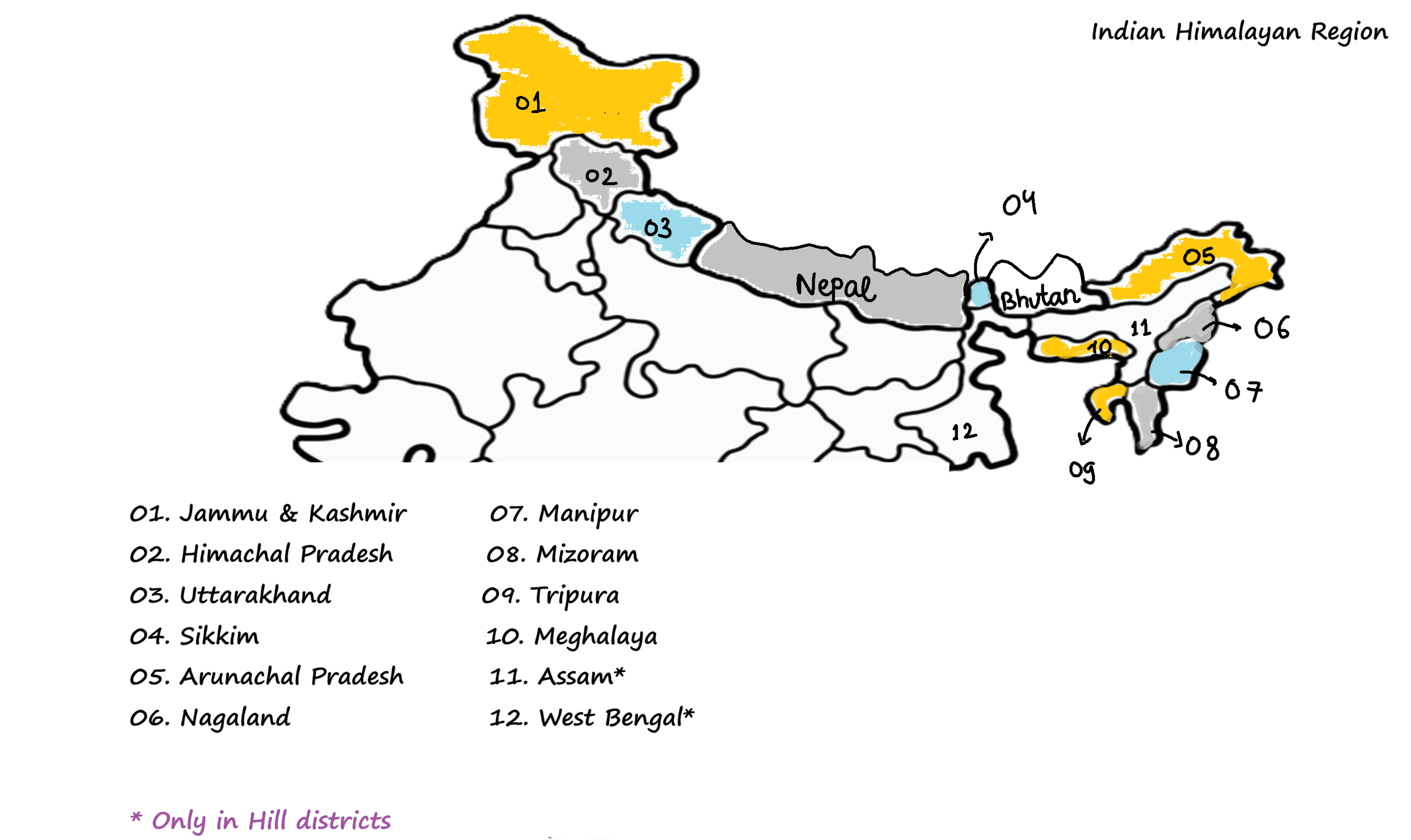
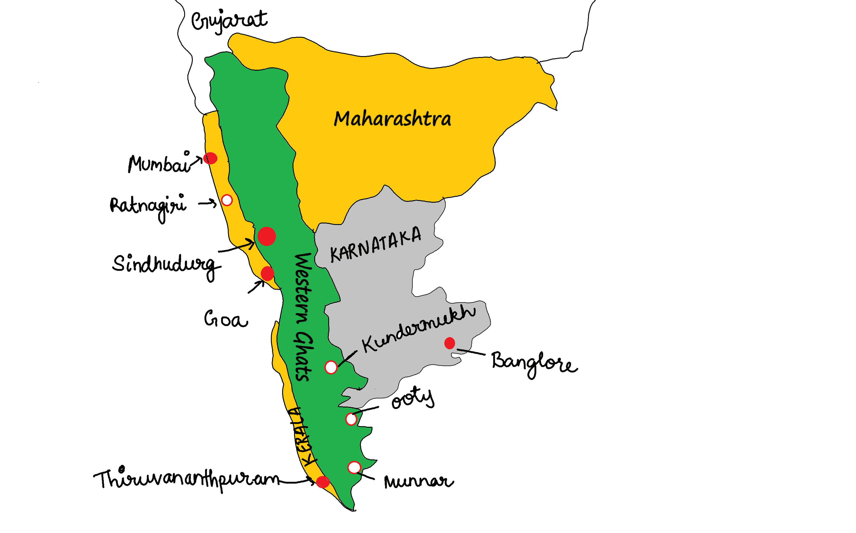
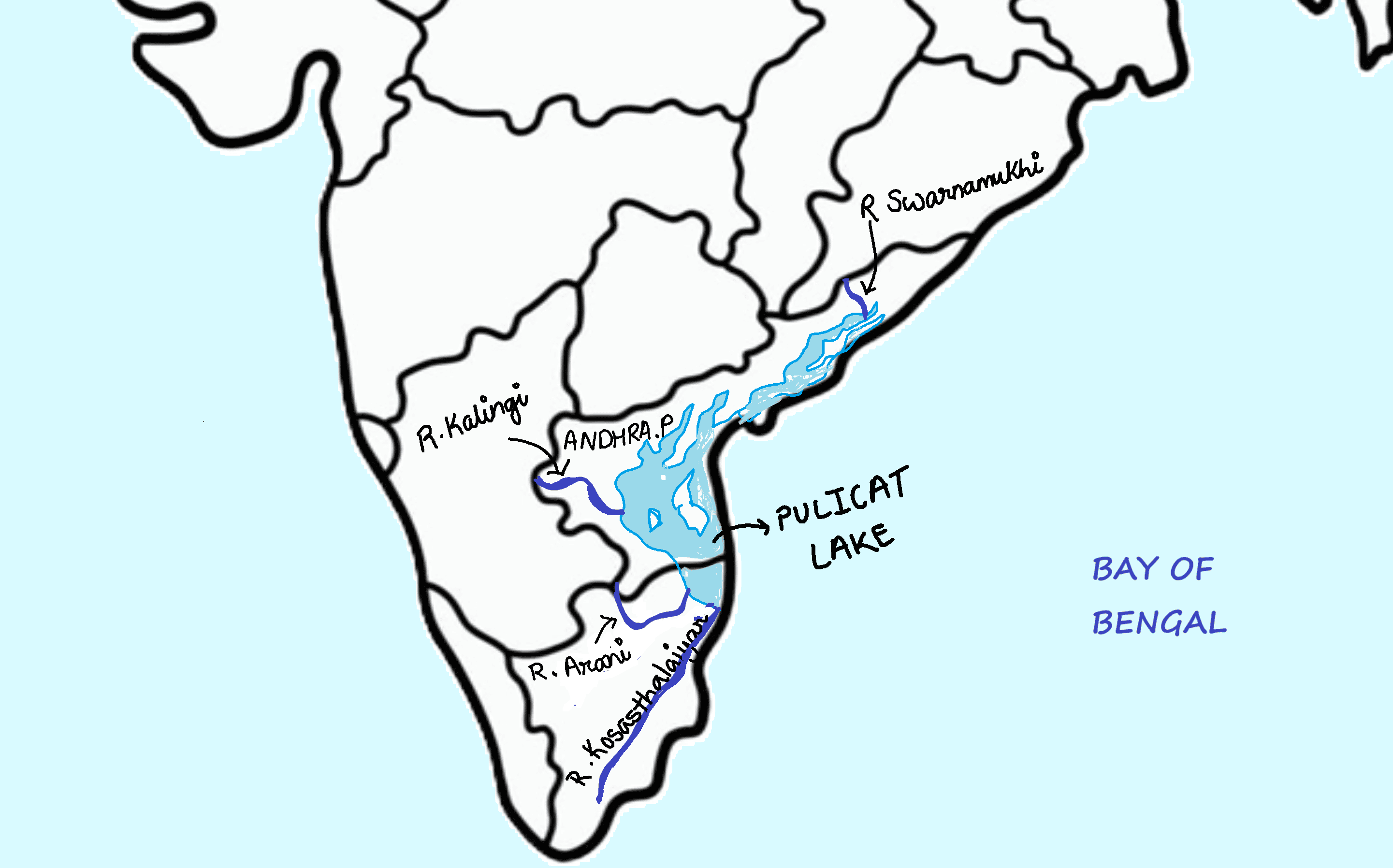
Consider the following statements:
- In India, the Himalayas are spread over five States only.
- The Western Ghats are spread over five States only.
- Pulicat Lake is spread over two States only.
Which of the statements given above is/are correct?
A. 1 and 2 only
B. 3 only
C. 2 and 3 only
D. 1 and 3 only
QUESTION 7
GS
Hard
Indian Geography
Prelims 2017
With reference to ‘Indian Ocean Dipole (IOD)’ sometimes mentioned in the news while forecasting Indian monsoon, which of the following statements is/are correct?
- IOD phenomenon is characterized by a difference in sea surface temperature between tropical Western Indian Ocean and tropical Eastern Pacific Ocean.
- An IOD phenomenon can influence El Nino’s impact on the monsoon.
Select the correct answer using the code given below:
A. 1 only
B. 2 only
C. Both 1 and 2
D. Neither 1 nor 2
