Disaster preparedness is the first step in any disaster management process. Explain how hazard zonation mapping will help disaster mitigation in the case of landslides.
Disaster preparedness is the first step in any disaster management process. Explain how hazard zonation mapping will help disaster mitigation in the case of landslides.
Hazard zonation mapping provides scientific foundation for disaster preparedness by identifying vulnerable areas and enabling targeted mitigation strategies. This systematic approach is essential for reducing landslide risks in India's mountainous regions.
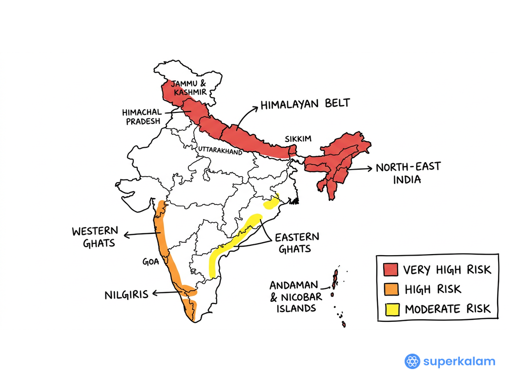
India Landslide Hazard Zonation Himalayan Belt
Scientific Assessment and Risk Identification
Geological and Terrain Analysis
- Slope stability assessment identifies unstable terrain through geological surveys and soil composition analysis
- Drainage pattern mapping reveals areas prone to water-induced slope failures and erosion
- Rock structure analysis determines fracture patterns and geological weaknesses that trigger landslides
- Digital Elevation Models (DEMs) provide precise slope angle measurements for risk calculation
- Geological Survey of India (GSI) has completed meso-scale mapping in 160 critical sectors across landslide-prone regions
Multi-Parameter Risk Evaluation
- Rainfall threshold mapping establishes precipitation levels that trigger landslide events
- Seismic vulnerability assessment identifies earthquake-prone areas with increased landslide risk
- Land use change analysis tracks deforestation and construction activities affecting slope stability
- Historical landslide inventory documents past events to predict future occurrences
- National Remote Sensing Centre (NRSC) uses 1:25,000 scale mapping for detailed hazard zonation
Mitigation Planning and Implementation
Early Warning Systems Development
- Real-time monitoring networks with rain gauges and slope movement sensors in high-risk zones
- Community-based warning systems established in Uttarakhand after 2013 Kedarnath disaster
- Mobile alert systems provide timely warnings to vulnerable populations
- Evacuation route planning based on safe zones identified through zonation maps
- Kerala's landslide warning system prevented casualties during 2024 Wayanad incidents
| Zonation Category | Risk Level | Mitigation Measures |
|---|---|---|
| Very High Risk | >75% probability | Relocation, structural measures |
| High Risk | 50-75% probability | Early warning, slope stabilization |
| Moderate Risk | 25-50% probability | Monitoring, land use regulation |
| Low Risk | <25% probability | General preparedness |
Infrastructure and Development Planning
- Construction guidelines for buildings in landslide-prone areas following IS 14458:1998 standards
- Road alignment planning avoids unstable slopes and incorporates drainage systems
- Afforestation programs on vulnerable slopes for natural stabilization
- Drainage management prevents water accumulation that triggers slope failures
- National Landslide Susceptibility Mapping covers 4.3 lakh sq km for development planning
Policy Integration and Governance
- Disaster Management Act 2005 mandates hazard mapping for all vulnerable districts
- Building codes enforcement in landslide-prone areas prevents unsafe construction
- Insurance premium calculation based on risk zones encourages safe practices
- Resource allocation optimization prioritizes high-risk areas for mitigation funding
Hazard zonation mapping transforms disaster preparedness from reactive to proactive approach, enabling evidence-based mitigation strategies. Integration with National Disaster Management Authority's guidelines and Sendai Framework implementation will enhance India's landslide resilience significantly.
Answer Length
Model answers may exceed the word limit for better clarity and depth. Use them as a guide, but always frame your final answer within the exam’s prescribed limit.
In just 60 sec
Evaluate your handwritten answer
- Get detailed feedback
- Model Answer after evaluation
Model Answers by Subject
Crack UPSC with your
Personal AI Mentor
An AI-powered ecosystem to learn, practice, and evaluate with discipline

