Mountain Passes of India: State-wise List with Map - UPSC
Apr, 2026
•6 min read
Mountain passes in India are natural routes that help people cross mountain ranges such as the Himalayas and Western Ghats. These passes can be narrow high-altitude paths or wider valleys, often found near rivers formed by snowmelt.
Although not completely flat, mountain passes are lower than the surrounding peaks, making them easier routes through tough terrain. Mountain passes in India are highly relevant to the UPSC geography and map-based questions.
Let's study this topic in detail!
What are Mountain Passes?
Mountain passes are natural routes through mountain ranges that make it easier to cross otherwise difficult and high terrain. They are lower than the surrounding peaks and formed over time by geological activity, erosion, and glaciers. These passes have been important for travel, trade, and cultural exchange.
In India, major mountain passes are found in the Himalayas and the Western Ghats. For example, Zoji La connects Ladakh with Jammu and Kashmir. Nathu La is an important link between India and Tibet with historical trade significance. In the Western Ghats, Palakkad Gap connects Kerala and Tamil Nadu.
Significance and Importance of Mountain Passes in India
Mountain passes in India are not just geographical features, but lifelines that connect remote regions, support national security, and drive economic and cultural interactions. Found mainly in the Himalayas and parts of the Western Ghats, these passes hold immense strategic and practical value.
1. Geopolitical and Strategic Importance
Many mountain passes lie along India’s international borders and connect the country with neighbours like China, Nepal, and Pakistan. Passes such as Nathu La and Khardung La are crucial for maintaining border connectivity and monitoring sensitive regions. They play a key role in diplomacy, trade agreements, and border management.
2. Military Significance
Mountain passes are vital for defence and military logistics. High-altitude routes such as the Karakoram Pass and Bomdi La enable the movement of troops, weapons, and supplies to border areas. Their control is essential for safeguarding national security, especially in conflict-prone regions.
3. Trade and Connectivity
Historically, mountain passes served as trade routes connecting India with Central Asia and Tibet. Passes like Shipki La were part of ancient trade networks such as the Silk Route. Even today, some passes facilitate cross-border trade and improve regional connectivity in remote areas.
4. Tourism and Economic Importance
Several mountain passes have become popular tourist destinations due to their scenic beauty and adventure opportunities. Rohtang Pass and Zoji La attract visitors for trekking, biking, and snow activities. Tourism around these passes contributes significantly to the local economy and employment.
5. Weather and Accessibility Challenges
Mountain passes often face extreme weather conditions such as heavy snowfall, avalanches, and landslides. Passes like Baralacha La and Zoji La remain closed during winters due to harsh climate, affecting transport and connectivity. This makes infrastructure development and maintenance a major challenge.
6. Cultural Exchange and Historical Role
Mountain passes have historically enabled the exchange of culture, ideas, and traditions between India and neighbouring regions. Routes through passes like Shipki La facilitated the movement of traders, pilgrims, and scholars, enriching cultural diversity over time.
7. Environmental Significance and Concerns
These high-altitude regions are environmentally sensitive. Issues like glacier melting, landslides, and climate change are increasingly affecting mountain passes. Sustainable development and careful management are necessary to preserve these fragile ecosystems while maintaining connectivity.
Major Mountain Passes in India with Elevation
The table below lists important mountain passes in India along with their states and approximate heights. This helps in quick revision for UPSC, especially for map-based and factual questions.
| Name of Pass | State / Region | Height (ft) |
|---|---|---|
| Asirgarh Pass | Madhya Pradesh | — |
| Bara-Lacha La | Ladakh / Himachal Pradesh | 16,400 |
| Banihal Pass | Jammu & Kashmir | 9,291 |
| Chang La | Ladakh | 17,800 |
| Dongkha La | Sikkim | 12,000 |
| Debsa Pass | Himachal Pradesh | 17,520 |
| Dhumdhar Kandi Pass | — | — |
| Goecha La | Sikkim | 16,207 |
| Fotu La | Ladakh | 13,451 |
| Haldighati Pass | Rajasthan | — |
| Jelep La | Sikkim | 14,300 |
| Indrahar Pass | Himachal Pradesh | 14,473 |
| Kunzum Pass | Himachal Pradesh | 14,931 |
| Khardung La | Ladakh | 18,380 |
| Lamkhaga Pass | Himachal Pradesh | 17,336 |
| Lachulung La | Ladakh | 16,600 |
| Mayali Pass | — | — |
| Marsimik La | Ladakh | 18,314 |
| Nathu La | Sikkim | 14,140 |
| Namika La | Ladakh | 12,139 |
| Rohtang Pass | Himachal Pradesh | 13,051 |
| Palakkad Gap | Kerala | ~1,000 |
| Sela Pass | Arunachal Pradesh | 14,000 |
| Sasser Pass | Ladakh | 17,753 |
| Tanglang La | Ladakh | 17,583 |
| Sin La | Uttarakhand | 18,028 |
| Zoji La | Ladakh | 12,400 |
| Traill's Pass | Uttarakhand | 17,100 |
Also read: 18 Biosphere Reserves in India: Features & Significance
State-wise List of Major Mountain Passes in India
Mountain passes in India are unevenly distributed across the Himalayas and the Western Ghats, playing a key role in connectivity, defence, and trade. The table below provides a concise state-wise overview of the mountain passes of India.
| Region/State | Mountain Pass | Importance |
|---|---|---|
| Leh–Ladakh | Khardung La | One of the highest motorable roads; connects Leh to Nubra Valley; crucial for Siachen logistics |
| Chang La | Connects Leh to Pangong Lake; extremely cold, high altitude | |
| Zoji La | Connects Ladakh with Kashmir Valley; strategic and prone to heavy snowfall | |
| Tanglang La | Among the highest passes, part of the Manali–Leh highway | |
| Bara-Lacha La | Connects Lahaul with Ladakh; key junction of multiple routes | |
| Imis La | Links Ladakh to Hanle Valley; less explored but strategic | |
| Jammu & Kashmir | Banihal Pass | Connects Jammu to Srinagar; now bypassed by Jawahar Tunnel |
| Pir Panjal Pass | Part of historic Mughal Road; it connects Rajouri and the Kashmir Valley | |
| Burzail Pass | Connects Astore Valley to Deosai Plains; scenic and strategic | |
| Pensi La | Connects Kashmir to Zanskar; important for tourism and transport | |
| Karakoram Pass | High-altitude pass on India–China border; historic trade route | |
| Himachal Pradesh | Rohtang Pass | Connects Kullu with Lahaul-Spiti; major tourist route |
| Shipki La | India–Tibet trade route in Kinnaur; restricted access | |
| Debsa Pass | Trekking route linking Kullu and Spiti valleys | |
| Bara-Lacha La | Important link on the, connecting the India–China Manali–Leh highway | |
| Uttarakhand | Mana Pass | One of the highest passes; connects India with Tibet; strategic |
| Niti Pass | Historic Indo-Tibet trade route; closed after 1962 | |
| Lipu Lekh Pass | Tri-junction of India, Nepal, Tibet; Kailash Mansarovar route | |
| Traill's Pass | Difficult trekking pass connecting Pindari and Milam valleys | |
| Muling La | Seasonal high-altitude pass near Gangotri | |
| North-East India | Nathu La | Key Indo-China trade and military route |
| Jelep La | Historic trade route between India and Tibet | |
| Bomdi La | Strategic military location in Arunachal | |
| Diphu Pass | The tri-junction of India, China, and Myanmar | |
| Pangsau Pass | Connects India to Myanmar; WWII significance | |
| Western Ghats | Bhor Ghat | Key rail-road link between Mumbai and Pune |
| Thal Ghat | Connects Mumbai to Nashik, an important transport route | |
| Palakkad Gap | Low-altitude pass linking Kerala and Tamil Nadu | |
| Shencottah Gap | Important corridor between southern states |
Also see: Biodiversity Hotspots in India: UPSC Notes & Facts
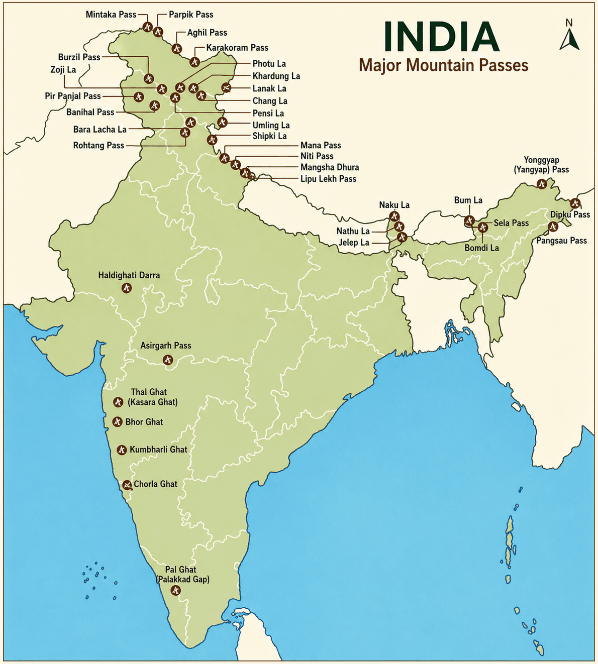
Mountain Passes of India Map
Click here: About West Asia: Countries & Map - UPSC
UPSC Prelims PYQs on Mountain Passes of India
QUESTION 1
GS
Medium
Indian Geography
Prelims 2015
Consider the following pairs:
| Place of Pilgrimage | Location |
|---|---|
| 1. Srisailam | Nallamala Hills |
| 2. Omkareshwar | Satmala Hills |
| 3. Pushkar | Mahadeo Hills |
Which of the above pairs is/are correctly matched?
Select an option to attempt
QUESTION 2
GS
Hard
Indian Geography
Prelims 2019
Consider the following pairs :
| Glacier | River |
|---|---|
| 1. Bandarpunch | Yamuna |
| 2. Bara Shigri | Chenab |
| 3. Milam | Mandakini |
| 4. Siachen | Nubra |
| 5. Zemu | Manas |
Which of the pairs given above are correctly matched?
Select an option to attempt
Final Words
Mountain passes in India are crucial for connectivity, defence, trade, and tourism. From the strategic heights of the Himalayas to the vital gaps in the Western Ghats, they play a key role in India’s geography and geopolitics.
For UPSC preparation, understanding the state-wise list of mountain passes in India, with map-based clarity, is essential for effectively solving both Prelims and Mains questions.
Also see: Most Important Maps for UPSC Preparation: Prelims and Mains
Start your UPSC Preparation 2026/2027 with SuperKalam
SuperKalam is your personal mentor for UPSC preparation, guiding you at every step of the exam journey. Practice, revise, and evaluate– all in one place.
Install Now