Iran-Israel War 2026: Map Locations & Bordering Nations
Jun, 2026
•6 min read
The Iran–Israel War 2026 has emerged as a major geopolitical crisis in West Asia, directly impacting global energy security, regional stability, and international diplomacy.
This conflict is highly relevant for UPSC GS Paper II (International Relations) and GS Paper I (World Geography). Understanding the strategic locations, bordering countries, and key maritime routes is essential to analyse the conflict from the UPSC exam perspective.
Let's learn geopolitics with mapping!
About Iran
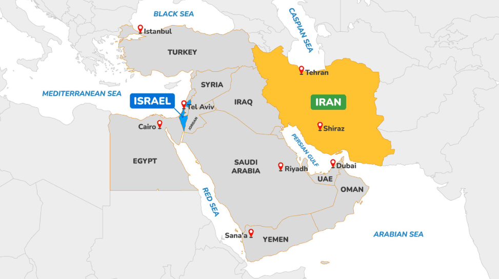
Iran is a large West Asian country strategically located in the Middle East. It lies between the Persian Gulf and the Gulf of Oman to the south and the Caspian Sea to the north.
With an area of about 1.65 million km², Iran is the second-largest country in the Middle East and ranks among the top 20 largest nations in the world. The capital city of Iran is Tehran, which is also its political, economic, and cultural centre.
Bordering Nations
Iran shares land borders with seven countries across all cardinal directions:
- North: Azerbaijan, Armenia, Turkmenistan (also meets the Caspian Sea)
- West: Turkey and Iraq
- East: Afghanistan and Pakistan
Maritime Boundaries
- Iran’s southern coastline along the Persian Gulf and Gulf of Oman spans roughly 1,770 km, making it central to key maritime routes, especially near the Strait of Hormuz.
- The Caspian Sea coast in the north extends about 740 km, and Iran holds maritime borders with neighbouring littoral states in this inland sea as well.
Rivers & Water Systems
Its mountain ranges and arid climate shape Iran’s hydrography, so it lacks very large river systems. Some important rivers include:
- Karun: One of Iran’s longest and only navigable rivers.
- Sefid-Rud: Flows from the Alborz Mountains into the Caspian Sea.
Other rivers, such as Karkheh, Mand, Atrak, Dez, and Zayandeh-Rud, support regional agriculture but are often seasonal or limited by climate.
Mnemonic for Iran Bordering Nations TAP AT AI
|
About Israel
Israel is a small but strategically significant country in West Asia, located on the eastern coast of the Mediterranean Sea. It lies at the junction of Asia, Africa, and Europe, making it geopolitically important. The capital city of Israel is Jerusalem, which serves as the country’s political and administrative centre.
Despite its small size (around 22,000 sq. km approx.), Israel holds high strategic relevance due to its location in the Levant region.
Bordering Nations
Israel shares land borders with four countries:
- North: Lebanon
- Northeast: Syria
- East: Jordan
- Southwest: Egypt
It also shares boundaries with the Palestinian Territories (the West Bank and the Gaza Strip), which remain central to regional conflict dynamics.
Maritime Frontiers
Israel has access to two important water bodies:
- West: Mediterranean Sea — major ports like Haifa are located here.
- South: Red Sea (through the Gulf of Aqaba) — gives access to the Indian Ocean trade routes.
Though Israel has a short coastline compared to other regional states, its maritime access is strategically significant for trade and security.
Major Rivers & Water Bodies
Israel has limited freshwater resources due to its semi-arid climate.
- Jordan River — the most important river, flowing from the north into the Dead Sea.
- Dead Sea — a hypersaline lake, one of the lowest points on Earth.
- Sea of Galilee (Lake Kinneret) — a major freshwater source.
Water security remains a major policy issue for Israel, influencing regional relations.
Gulf Nations in Focus — Borders & Strategic Location
In the context of the Iran–Israel conflict, the Gulf countries are strategically important due to their proximity to Iran, dependence on maritime trade, and role in global energy supply.
1. United Arab Emirates (UAE)
Location: Southeast of the Arabian Peninsula, along the Persian Gulf.
Capital City: Abu Dhabi
Land Borders:
- Saudi Arabia (West & South)
- Oman (Southeast)
Maritime Boundary:
- Persian Gulf
- Gulf of Oman
2. Kuwait
Location: Northern edge of the Persian Gulf.
Capital City: Kuwait City
Land Borders:
- Iraq (North & West)
- Saudi Arabia (South)
Maritime Boundary:
- Persian Gulf
3. Bahrain
Location: Island nation in the Persian Gulf.
Capital City: Manama
Land Borders: No land borders (island country)
Maritime Neighbours:
- Saudi Arabia (connected via the King Fahd Causeway)
- Iran (across Persian Gulf waters)
4. Saudi Arabia
Location: The largest country in West Asia, occupying most of the Arabian Peninsula.
Capital City: Riyadh
Land Borders:
- Jordan
- Iraq
- Kuwait
- Qatar
- United Arab Emirates
- Oman
- Yemen
Maritime Boundaries:
- Red Sea (West)
- Persian Gulf (East)
5. Qatar
Location: Peninsula extending into the Persian Gulf.
Capital City: Doha
Land Borders: Saudi Arabia (South)
Maritime Boundary: Persian Gulf
6. Oman
Location: Southeastern corner of the Arabian Peninsula.
Capital City: Muscat
Land Borders:
- Saudi Arabia
- United Arab Emirates
- Yemen
Maritime Boundaries:
- Arabian Sea
- Gulf of Oman
Oman controls part of the coastline near the Strait of Hormuz, making it extremely important in the Iran–Gulf security context.
Also read: India-Middle East Relations: History, Trade, and Strategic Ties
Strait of Hormuz
The Strait of Hormuz is one of the world’s most important maritime chokepoints. In the ongoing 2026 Iran–Israel conflict, it has gained global attention because about 20% of the world’s oil trade moves through this narrow passage.
Recently, Iran’s Islamic Revolutionary Guard Corps (IRGC) declared the strait “closed” and warned that any vessel trying to pass would be attacked or set ablaze, a move that could disrupt global energy supplies.
Where is the Strait of Hormuz Located?
- It links the Persian Gulf with the Gulf of Oman.
- Beyond the Gulf of Oman, ships enter the Arabian Sea and then the Indian Ocean.
- Nearby locations include Bandar Abbas (Iran) and Musandam (Oman).
The strait lies between:
- Iran on the north side, and
- Oman (Musandam Peninsula) and parts of the UAE on the south side.
It is the only sea gateway for Gulf oil producers into the wider world ocean.
Why is it Strategically Important?
- Global Energy Route: Nearly one-fifth of the world’s petroleum trade passes through this strait. Major exporters such as Saudi Arabia, Iraq, Kuwait, UAE and Qatar depend on it to transport oil and gas.
- Military Significance: The U.S. and allied naval forces maintain a presence at the Strait of Hormuz. Iran has repeatedly warned it could block the strait during conflicts. Any blockade would impact Europe, Asia, and especially India (which imports oil from this region).
- India’s Interests: India imports a large share of crude oil from Gulf nations. Disruption would affect inflation, fiscal stability, and energy security.
Persian Gulf
The Persian Gulf is a shallow marginal sea of the Indian Ocean, located in West Asia between the Arabian Peninsula and Iran. It connects to the Gulf of Oman through the Strait of Hormuz.
It is one of the most strategically important water bodies in the world due to its vast oil and natural gas reserves.
Bordering Countries
The Persian Gulf is bordered by:
- North: Iran
- South & West: Iraq, Kuwait, Saudi Arabia, Bahrain, Qatar, United Arab Emirates, Oman
Mnemonic: QUBOKS I2 Q Qatar U UAE B Bahrain O Oman K Kuwait S Saudi Arabia I2 Iran & Iraq |
Strategic Importance
- One of the world’s largest oil-producing regions.
- Around one-fifth of global petroleum trade passes through this region.
- Important for global energy security and international trade.
Gulf of Oman
The Gulf of Oman is a western extension of the Arabian Sea that connects the Persian Gulf with the Indian Ocean. It lies between Iran in the north and Oman and Pakistan in the south. The Strait of Hormuz connects the Gulf of Oman to the Persian Gulf. Important ports at the Gulf of Oman are Gwadar (Pakistan) and Chabahar (Iran).
Bordering Countries
- North: Iran
- South: Oman, United Arab Emirates
- East: Pakistan
Strategic Importance
- Acts as the gateway for ships leaving the Persian Gulf.
- Important for oil transportation and maritime trade.
- Frequently in the news due to naval tensions and shipping security in West Asia.
Caspian Sea
The Caspian Sea is the largest inland water body in the world and lies between Europe and Asia. Despite being called a “sea,” it is technically a landlocked water body. It is surrounded by five countries and is rich in oil and natural gas resources. Major rivers flowing into the Caspian Sea are the Volga River and the Ural River.
Bordering Countries
- North: Russia
- East: Kazakhstan, Turkmenistan
- South: Iran
- West: Azerbaijan
Mnemonic: TARIK T Turkmenistan A Azerbaijan R Russia I Iran K Kazakhstan |
Strategic Importance
- Rich reserves of oil and natural gas.
- Important for energy transportation and regional geopolitics.
- Central to cooperation and disputes among the Caspian littoral states.
Mediterranean Sea
The Mediterranean Sea is a large intercontinental sea located between Europe, Africa, and Asia. It is connected to the Atlantic Ocean through the Strait of Gibraltar.
The sea forms an important geographical and historical region known as the Mediterranean Basin, which has been a centre of trade, culture, and civilisation for thousands of years.
Bordering Regions and Countries
The Mediterranean Sea is surrounded by:
Northern Coast (Europe):
- Spain
- France
- Monaco
- Italy
- Slovenia
- Croatia
- Bosnia and Herzegovina
- Montenegro
- Albania
- Greece
Eastern Coast (West Asia):
- Turkey
- Syria
- Lebanon
- Israel
Southern Coast (North Africa):
- Egypt
- Libya
- Tunisia
- Algeria
- Morocco
Important Seas and Sub-Regions
The Mediterranean Sea includes several smaller seas and gulfs:
- Adriatic Sea
- Aegean Sea
- Ionian Sea
- Tyrrhenian Sea
The Mediterranean Sea is almost completely enclosed by land, which gives it the characteristics of a semi-enclosed sea.
Important Straits and Connections
The Mediterranean Sea is connected to other major water bodies through several strategic straits:
- Strait of Gibraltar → Atlantic Ocean
- Suez Canal → Red Sea
- Dardanelles Strait → Sea of Marmara
- Bosporus Strait → Black Sea
These passages make the Mediterranean a major global trade route.
Strategic Importance
- Historically important for trade, cultural exchange, and empires such as the Roman and Greek civilisations.
- Connects Europe, Asia, and Africa, making it a major geopolitical region.
- An important shipping route linking Europe with Asia via the Suez Canal.
- Plays a key role in West Asian geopolitics, especially for Israel.
UPSC Prelims PYQs Based on World Mapping
QUESTION 1
GS
Medium
World Geography
Prelims 2017
The Mediterranean Sea is a border of which of the following countries?
- Jordan
- Iraq
- Lebanon
- Syria
Select the correct answer using the code given below:
Select an option to attempt
QUESTION 2
GS
Medium
World Geography
Prelims 2019
Consider the following pairs:
| Sea Bordering | Country |
|---|---|
| 1. Adriatic Sea | Albania |
| 2. Black Sea | Croatia |
| 3. Caspian Sea | Kazakhstan |
| 4. Mediterranean Sea | Morocco |
| 5. Red Sea | Syria |
Which of the pairs given above are correctly matched?
Select an option to attempt
QUESTION 3
GS
Easy
International Relations
Prelims 2016
Which of the following is not a member of ‘Gulf Cooperation Council’?
Select an option to attempt
QUESTION 4
GS
Hard
World Geography
Prelims 2020
Consider the following pairs:
| River | Flows into |
|---|---|
| 1. Mekong | Andaman Sea |
| 2. Thames | Irish Sea |
| 3. Volga | Caspian Sea |
| 4. Zambezi | Indian Ocean |
Which of the pairs given above is/are correctly matched?
Select an option to attempt
Conclusion
Understanding the geography of West Asia is essential for analysing the Iran–Israel conflict and its wider global impact.
Regularly revise these locations through PYQs, MCQ practice, and blank map exercises. Consistent map-based revision will strengthen your Prelims preparation and also help you write more analytical answers in GS Paper I and GS Paper II.
Start your UPSC Preparation 2026/2027 with SuperKalam
SuperKalam is your personal mentor for UPSC preparation, guiding you at every step of the exam journey. Practice, revise, and evaluate– all in one place.
Prepare UPSC Current Affairs Smarter with SuperKalam
Get daily current affairs summaries, practice MCQs daily, maintain your streak, and build discipline for UPSC exam preparation.
Get Access Now


