Why India Is a Subcontinent: Plate Tectonics and the Monsoon Engine
How an anomalous continental collision forged an isolated tectonic fortress, powering planetary cooling and the monsoon engine that sustains South Asia.
Nov, 2026
•12 min read
Overview
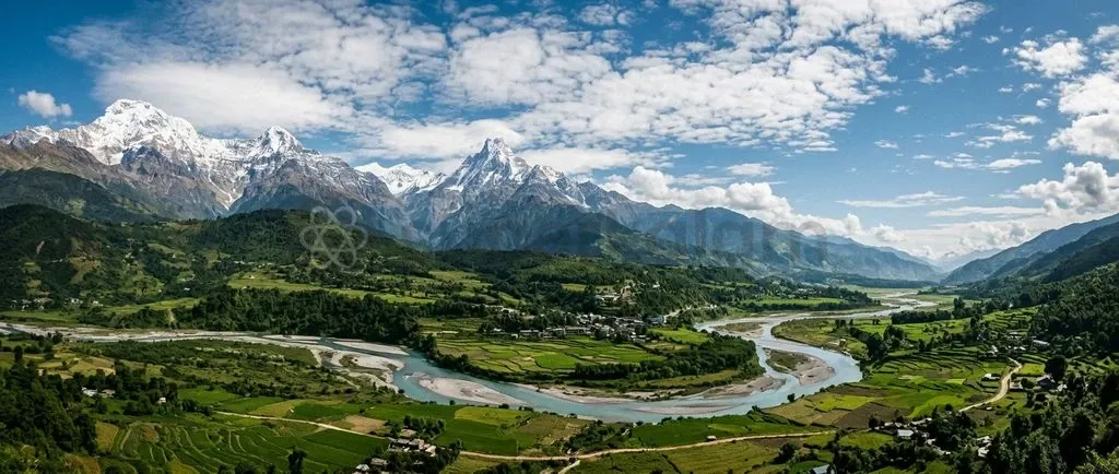
India is geodynamically classified as a subcontinent because it occupies an independent continental plate. The landmass is bounded by the Indus-Tsangpo Suture Zone, the Chaman fault system, and the Indo-Burman Ranges, separating it from the rest of Eurasia.
Following a mantle plume-driven northward drift across the prehistoric Tethys Ocean, the rigid Indian craton slammed into Eurasia. This impact uplifted the Himalayan wall and the Tibetan Plateau. The structural barrier shields South Asia from freezing Siberian katabatic winds and drives the moisture-laden South Asian Summer Monsoon.
This geographic entity is a self-contained climatic and geodynamic engine that feeds sediment into the fertile Indo-Gangetic basin. As of April 2024, continuous northward plate convergence sustains active mountain building, persistent seismic stress, and regional atmospheric circulation.
What Makes a Landmass a Subcontinent?
Geoscientists define the Indian subcontinent as an independent lithospheric plate enclosed by discrete tectonic sutures rather than an arbitrary political subdivision. According to the Geological Survey of India and the Wadia Institute of Himalayan Geology (PIB Release), this distinct plate is demarcated by three active tectonic boundaries:
- The Indus-Tsangpo Suture Zone in the north
- The Chaman transform fault system in the west
- The Indo-Burman Ranges accretionary wedge in the east
Together, these sutures physically disconnect the peninsular shield from the Eurasian mainland. Unlike a conventional peninsula, which merely projects into an ocean from a shared continental mass, a subcontinent carries an autonomous lithospheric foundation.
The Indian landmass preserved its own geologic identity throughout millions of years of isolated oceanic drift. Geodynamic independence produced distinct crystalline basements, deep-seated cratonic roots, and an enclosed environmental theatre that operates independently of adjacent weather systems.
| Geodynamic Feature | Conventional Peninsula (e.g., Iberia, Arabia) | Subcontinent (Indian Landmass) | Full Continent (e.g., Africa, Eurasia) |
|---|---|---|---|
| Lithospheric Integrity | Contiguous extension of parent continental plate | Autonomous tectonic plate with distinct crustal boundaries | Massive, composite continental landmass |
| Bounding Margins | Passive oceanic shorelines and unsegmented land bridges | Active structural sutures (Indus-Tsangpo, Chaman Fault) | Multiple collision zones, passive margins, and rifts |
| Climatic Autonomy | Modulated directly by ambient continental weather systems | Self-contained engine driving the South Asian Summer Monsoon | Hosts multiple independent global climate regimes |
| Foreland Deposition | Minor coastal deltas or localised grabens | Massive flexural basin spanning 250,000 square kilometres | Vast continental interior basins and cratonic shields |
Regional identity stems from this profound mechanical isolation. The enclosing geological boundaries restrict terrestrial biotic migration and divert atmospheric flow. Over millennia, this created an ecological crucible that has endured as a coherent civilisational unit.
Discuss with Superkalam
Can you recall the three active tectonic suture boundaries that physically separate the Indian plate from Eurasia?
Ask NowThe Fast Drift: How the Indian Plate Broke Away and Raced North
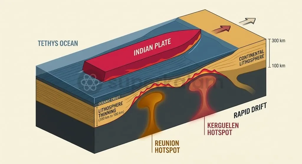
The Indian plate separated from Gondwanaland during the mid-Cretaceous period before embarking on the fastest recorded continental drift in Earth's tectonic history. Tectonic reconstructions published in Nature by Kumar et al. reveal that the Indian plate accelerated to an anomalous peak velocity of 18 to 20 centimetres per year at approximately 67 to 52 million years ago.
Normal continental drift typically crawls at a modest pace of 2 to 4 centimetres per year. This tenfold acceleration transformed the northward migration into a geologic sprint across the ancient Tethys Ocean basin.
| Plate Movement Stage | Velocity Rate |
|---|---|
| Typical Continental Drift | 2 to 4 centimetres per year |
| Indian Plate (Peak Velocity) | 18 to 20 centimetres per year |
Exceptional speed stemmed from severe basal thinning driven by deep mantle upwellings. As documented by Kumar et al. in Nature, thermal erosion from the Réunion and Kerguelen hotspots shaved the Indian continental lithosphere from an initial thickness of 200 to 300 kilometres down to roughly 100 kilometres depth.
The drastically thinned lithospheric keel experienced minimal basal drag against the convective asthenosphere. This sharp reduction in frictional resistance allowed sub-crustal mantle currents to propel the plate across the hemisphere with unprecedented speed.
The Collision Zone: How Crustal Folding Built the Northern Shield
The Cenozoic collision of the rigid Indian shield into the Eurasian landmass initiated intense crustal folding, absorbing thousands of kilometres of convergence to build the Himalayan mountain belt. According to classic indentation analyses by Molnar and Tapponnier in Science, the relentless impact of the rigid Indian craton compressed the weaker Eurasian margin, absorbing over 2,000 kilometres of Cenozoic convergence.
This tectonic squeezing triggered extensive horizontal crustal shortening. Consequently, crustal thickness beneath the Tibetan Plateau doubled to approximately 70 to 75 kilometres, forming the highest topographic upland on Earth.
Crustal deformation migrated progressively southward across the collision front through three major south-propagating fault systems. Research from the Department of Science and Technology and the Wadia Institute of Himalayan Geology outlines how strain transferred sequentially through the crust:
- The Main Central Thrust (MCT), which accommodated massive ductile shearing and high-grade metamorphic stacking during early orogenic stages.
- The Main Boundary Thrust (MBT), which subsequently folded and overthrust the Lesser Himalayan sedimentary sequences.
- The Main Frontal Thrust (MFT), which represents the southernmost active seismic front, directly truncating the Siwalik foothills against the alluvial plains.
As of April 2024, geodetic observations published by the Geological Survey of India and the Tectonics Journal indicate that the Indian plate continues to push into stable Eurasia at an active rate of 40 to 50 millimetres per year. The Himalayan mountain arc directly absorbs roughly 15 to 20 millimetres per year of this convergence. Stored elastic strain along these locked faults periodically unleashes destructive, high-magnitude earthquakes, confirming that the subcontinent's northern boundary remains actively under construction.
Discuss with Superkalam
Explain in your own words how the thermal erosion of the lithospheric keel enabled the Indian plate to drift at an anomalous speed of 18 to 20 centimetres per year.
Ask NowHow the High Plateau Drives the Asian Monsoon Engine
The elevated Tibetan Plateau is an enormous mid-tropospheric thermal engine, altering planetary wind belts and anchoring the seasonal South Asian Summer Monsoon system. Physical relief along the Himalayan barrier forms an uncompromising meteorological divide across contrasting seasons.
The NCERT textbook on India's physical environment highlights that the mountain wall blocks freezing, dry katabatic winds from the Siberian and Central Asian High from sweeping south into Northern India during winter. Conversely, reports from the India Meteorological Department confirm that the same relief mechanically arrests the northward propagation of the South Asian Summer Monsoon, forcing moisture-heavy maritime air to undergo intense orographic ascent across the foothills.
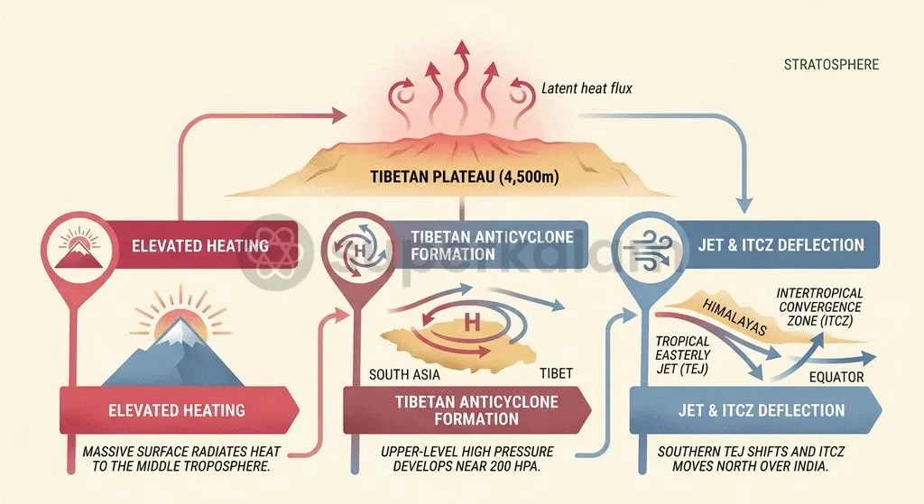
Atmospheric heating across the plateau transforms regional pressure gradients into a powerful atmospheric pump. Research by Yanai et al. in the Journal of the Meteorological Society of Japan demonstrates that the Tibetan Plateau, averaging 4,500 metres elevation across roughly 2.5 million square kilometres, injects massive sensible heat into the middle troposphere during spring.
| Seasonal Phase | Thermal & Aerodynamic Mechanism |
|---|---|
| Spring Pre-Heating | Sensible heat flux across 4,500 metres elevation warms the mid-troposphere |
| Early Summer Convection | Latent heat release superheats the upper troposphere, creating the Tibetan High at 200 hectopascals |
| Monsoon Onset | ITCZ pulled to 20°N–25°N; upper-level Tropical Easterly Jet steers depressions |
Thermal suction drives planetary-scale circulation shifts that inaugurate the rainy season. As detailed in NCERT climatology records, intense thermal depression over Northwestern India and the Tibetan Plateau pulls the Intertropical Convergence Zone northwards to 20°N–25°N over the Gangetic Plain.
This displacement causes southern trade winds to surge across the equator, deflecting northeastward as the Southwest Monsoon. Simultaneously, pioneering work by meteorologist P. Koteswaram in Tellus showed that the resulting upper-tropospheric Tibetan High at 200 hectopascals initiates and sustains the Tropical Easterly Jet, steering monsoon depressions across the fertile core of the subcontinent.
Discuss with Superkalam
If the elevation of the Tibetan Plateau were significantly lower than 4,500 metres, how might the seasonal positioning of the ITCZ and the Tropical Easterly Jet be affected?
Ask NowRain Shaping Mountains: The Feedback Loop Between Weather and Rocks
Intense monsoon rainfall and Himalayan mountain uplift form a coupled morphotectonic feedback loop, where concentrated surface erosion directly accelerates crustal deformation and rock exhumation. Geodynamic modelling by Beaumont et al. in Nature demonstrates that atmospheric weather and deep-crustal tectonics operate as tightly coupled mechanics.
High-intensity monsoonal deluges strike the southern Himalayan front, generating rapid river incision and denudation. This localised unloading removes massive volumes of upper-crustal overburden, decompressing the deep mountain roots. Weakened by high heat, ductile mid-crustal metamorphic rock is extruded toward the surface through tectonic channel flow.
Localised erosion peaks at structural choke points along the mountain chain:
- Western Syntaxis: Ferocious fluvial incision by the Indus River carves deep bedrock gorges.
- Eastern Syntaxis: The Yarlung Tsangpo-Brahmaputra gorge rapidly strips away upper crustal layers.
- Exhumation Mechanism: These river gorges create tectonic aneurysms, pulling hot metamorphic rocks upward to the surface.
According to Zeitler et al. in GSA Today, these drainage networks strip away upper crustal layers at exceptional rates. Climatic rainfall therefore actively dictates where faults rupture, how rock exhumation proceeds, and how the physical borders of the subcontinent evolve over geological timescales.
Discuss with Superkalam
Analyse the feedback mechanism between intense monsoonal surface erosion and the extrusion of ductile rock through tectonic channel flow.
Ask NowThe Global Thermostat: How Himalayan Weathering Cooled the Planet
The tectonic uplift of the Himalayas triggered widespread chemical weathering of silicate rocks, pulling carbon dioxide from the atmosphere and plunging the Cenozoic Earth into long-term global cooling. Emerging mountain ranges exposed vast volumes of fresh crystalline silicates to warm, monsoonal precipitation.
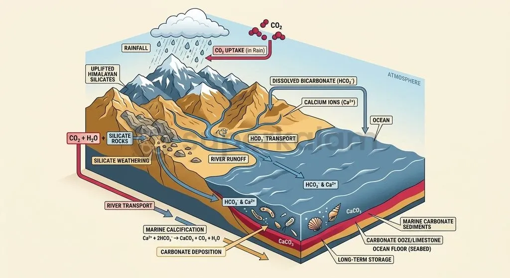
According to the foundational Raymo-Ruddiman hypothesis published in Nature, accelerated chemical silicate weathering broke down calcium- and magnesium-bearing rocks through chemical interaction with dissolved carbonic acid. This process transformed gaseous atmospheric carbon dioxide into soluble bicarbonate ions, which rivers transported to the oceans for burial as marine carbonate sediments.
Tectonic silicate weathering drives atmospheric carbon drawdown through a three-stage geochemical sequence:
- Atmospheric interaction: Atmospheric CO₂ dissolves into rainfall to generate carbonic acid (H₂CO₃).
- Silicate breakdown: Carbonic acid reacts with calcium- and magnesium-bearing rocks, releasing dissolved bicarbonate ions (HCO₃⁻).
- Carbonate burial: Rivers discharge dissolved bicarbonate into the sea, locking away carbon in long-term marine carbonate sediments.
Marine geochemical proxies corroborate this tectonic carbon sequestration model. Geochemical analyses documented by Raymo and Ruddiman reveal that oceanic strontium isotope ratios (87Sr/86Sr ratios) increased by approximately 50% from the late Eocene through the Neogene.
This distinct isotopic shift reflects a vast influx of dissolved weathering products carried down into the global ocean primarily by the Himalayan-Tibetan river systems. Tectonic uplift and monsoonal weathering combined to drive planetary cooling, drawing down greenhouse gas concentrations and pushing global climates from greenhouse warmth toward Quaternary glaciation.
The Sinking Basin: How Silt Built the Subcontinent's Breadbasket
The massive structural weight of the rising Himalayas bent the Indian tectonic plate downward, carving the deep Indo-Gangetic foreland basin that today underpins South Asian food security. Geophysical investigations by Lyon-Caen and Molnar in the Journal of Geophysical Research demonstrate that the immense topographic mass of the advancing mountain thrusts caused downward flexural bending of the underthrusting Indian lithosphere.
As the continental plate warped downward under this crustal load, a peripheral depression emerged along the southern mountain front. This structural depression became a sediment sink, capturing the weathered detritus of the rising orogen.
Exploratory boreholes and seismic receiver function analyses by Borah et al. confirm the asymmetrical geometry of the foreland basin:
- Along the northern edge of the peninsular craton, sediment deposits measure a modest 1 kilometre depth.
- Immediately adjacent to the Himalayan frontal thrusts, the syn-orogenic alluvial sediment wedge plunges to up to 6 kilometres depth.
- Fluvial sorting across this depression organised sedimentary strata into alternating layers of coarse gravels, porous sands, and dense silts.
Deposition across this structural depression created an unmatched agrarian resource. Synthesis by Gupta published by Cambridge University Press notes that the resulting alluvial basin spans 250,000 square kilometres, yielding fertile soils that support roughly 10% of the world's population. Without the tectonic downwarping that trapped this alluvial sediment, the subcontinent would lack the perennial groundwater aquifers and deep agricultural soils that historically allowed dense riverine civilisations to flourish.
Discuss with Superkalam
Evaluate whether the Tibetan Plateau's thermal engine or the Himalayan mechanical barrier plays the more decisive role in establishing the South Asian monsoon regime.
Ask NowWhy Geological Isolation Still Defines South Asian Realities
The structural enclosure forged by the Himalayan collision zone and enclosing ocean basins continues to dictate the ecological vulnerabilities, economic corridors, and strategic geography of South Asia. Transboundary river basins mirror the physical unity of this underlying terrain.
Upstream glacial dynamics and monsoon run-off along the Indus, Ganga, and Brahmaputra drainage networks tie upstream hazards in the mountains directly to agricultural output across India, Pakistan, and Bangladesh. Managing transboundary siltation, glacial lake outburst floods, and seasonal inundation demands integrated basin-wide governance.
| Structural Challenge | Regional Impact on South Asia |
|---|---|
| Transboundary River Systems | Upstream glacial melt directly dictates downstream food security in India, Pakistan, and Bangladesh |
| Frontal Thrust Seismicity | Active convergence along the Main Frontal Thrust exposes urban centres and dams to severe earthquake risk |
| Geomorphic Enclosure | Suture zone relief and steep ranges elevate construction costs and cause recurrent landslide hazards |
Modern connectivity and security architectures remain fundamentally constrained by the collision front. Rugged relief along the Indus-Tsangpo suture and the steep Indo-Burman ranges imposes steep engineering costs and recurrent landslide hazards on regional infrastructure projects.
Because tectonic convergence across the Main Frontal Thrust remains active, every transport corridor, energy network, and urban centre throughout the foothills must be engineered for persistent seismicity. Recognising that South Asia is an interdependent geodynamic system provides the physical baseline for resilient spatial planning, disaster mitigation, and natural resource stewardship.
Key Takeaways
- Geodynamic Definition: India is an independent lithospheric plate delimited by the Indus-Tsangpo Suture Zone, the Chaman transform fault, and the Indo-Burman Ranges accretionary wedge, establishing it as a distinct subcontinent rather than a simple peninsula.
- Anomalous Drift: Propelled by thermal erosion and lithospheric thinning from the Réunion and Kerguelen mantle plumes, the Indian plate accelerated to an unprecedented velocity of 18 to 20 cm/year around 67 to 52 Ma.
- Collision and Orography: Indentation tectonics absorbed over 2,000 km of convergence, doubling crustal thickness under the Tibetan Plateau to 70–75 km and driving active modern convergence at 40 to 50 mm/year.
- Monsoonal Engine: The Tibetan Plateau is a 4,500-metre-high thermal heat pump that generates the Tibetan High, initiates the Tropical Easterly Jet, and anchors the northward migration of the ITCZ.
- Tectonic-Climatic Coupling: Extreme monsoonal downpours trigger rapid river incision, promoting ductile crustal extrusion through tectonic channel flow and localised tectonic aneurysms.
- Sediment Cradle: Flexural downwarping created the 250,000 km² Indo-Gangetic basin, trapping an alluvial sediment wedge up to 6 km deep that sustains 10% of humanity.
Mains Question
"The Indian subcontinent operates as a self-contained climatic and geodynamic engine defined by discrete tectonic boundaries." In this context, examine how lithospheric margins and the Tibetan upland collectively govern the South Asian atmospheric circulation. (10 Marks)
Evaluate NowMains Question
"Climatic rainfall actively dictates where faults rupture, how rock exhumation proceeds, and how continental borders evolve over geological timescales." Elucidate the morphotectonic feedback loop connecting surface denudation and deep-crustal deformation along the Himalayan arc. (15 Marks)
Evaluate NowPractice MCQs
QUESTION 1
Consider the following statements regarding the tectonic movement of the Indian plate:
- The Indian plate accelerated to a peak velocity of 18 to 20 centimetres per year during its northward drift across the prehistoric Tethys Ocean.
- Thermal erosion from the Réunion and Kerguelen hotspots thinned the Indian lithosphere to approximately 100 kilometres depth, significantly reducing basal drag.
- Typical continental drift rates globally average between 15 to 20 centimetres per year. Which of the statements given above are correct?
QUESTION 2
With reference to the structural fault systems accommodating convergence in the Himalayan collision zone, consider the following statements:
- The Main Central Thrust accommodated ductile shearing and high-grade metamorphic stacking during early orogenic stages.
- The Main Boundary Thrust folded and overthrust the Lesser Himalayan sedimentary sequences.
- The Main Frontal Thrust represents the southernmost active seismic front, directly truncating the Siwalik foothills against the alluvial plains. Which of the statements given above are correct?
QUESTION 3
Consider the following statements regarding the meteorological impact of the Tibetan Plateau and the Himalayan barrier:
- The Himalayan relief blocks freezing, dry katabatic winds originating from the Siberian and Central Asian High from entering Northern India during winter.
- Sensible heat flux across the elevated Tibetan Plateau warms the middle troposphere during spring.
- Latent heat release in early summer creates the upper-tropospheric Tibetan High at 200 hectopascals, which sustains the Tropical Easterly Jet. Which of the statements given above are correct?
QUESTION 4
Consider the following statements regarding morphotectonic interactions in the Himalayas:
- Intense monsoonal deluges trigger rapid river incision and denudation, unloading upper-crustal overburden.
- Crustal unloading permits ductile mid-crustal metamorphic rock to be extruded toward the surface via tectonic channel flow.
- Tectonic aneurysms develop at the structural choke points of the Indus and Yarlung Tsangpo-Brahmaputra river gorges. Which of the statements given above are correct?
QUESTION 5
According to geodetic observations published by the Geological Survey of India, what portion of the Indian plate's active 40 to 50 millimetres per year convergence rate is directly absorbed by the Himalayan mountain arc?