Tsunami Warning Systems: Science, Governance, and Coastal Resilience
Two decades after the 2004 disaster, coastal resilience requires bridging the vital gap between INCOIS ocean telemetry and grassroots community evacuation.
Nov, 2026
•12 min read
Overview
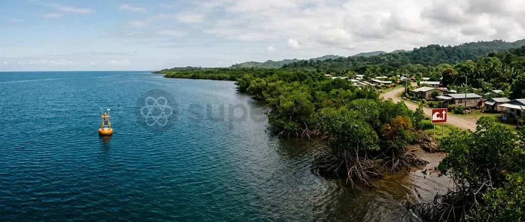
The 2004 Indian Ocean disaster transformed international coastal safety from reactive crisis response to proactive ocean observation. Littoral countries established high-precision sensor networks that detect tsunamigenic undersea seismic ruptures within minutes.
Offshore scientific precision alone cannot prevent loss of life. While the Indian Tsunami Early Warning Centre operationalises ocean bottom pressure recorders and hydrodynamic numerical models with millimetre-level precision, the system collapses if last-mile evacuation fails. Deep-sea sensing, statutory disaster governance under the Disaster Management Act, 2005, and living mangrove bioshields must operate in tandem to withstand sudden marine inundations.
Why 2004 Still Dictates Global Tsunami Strategy Twenty Years Later
The 26 December 2004 disaster remains the benchmark for global marine hazard management. The cataclysm was triggered by a massive undersea earthquake measuring moment magnitude (Mw) 9.1 to 9.3 along the Sunda subduction zone, as documented by the. This seismic event ruptured nearly 1,300 kilometres of the tectonic plate interface.
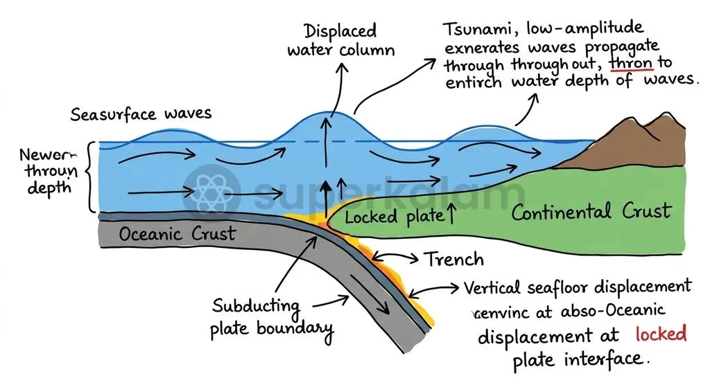
Vertical seafloor displacement lifted the seabed by several metres. This displaced hundreds of cubic kilometres of water and launched waves across the entire ocean basin. The catastrophe exposed three structural vulnerabilities across the region:
- Total Sensor Deficit: Coastal populations across fourteen littoral countries received no institutional warning because the Indian Ocean basin lacked coordinated deep-sea sensor infrastructure in 2004.
- Absence of Basin-Wide Coordination: In direct response to this catastrophic void, the Intergovernmental Oceanographic Commission of UNESCO convened member states in July 2005. Through Resolution XXIII-12, the commission established the Intergovernmental Coordination Group for the Indian Ocean Tsunami Warning and Mitigation System (ICG/IOTWMS).
- Reactive Statutory Frameworks: India overhauled its domestic governance architecture to institutionalise modern disaster preparedness. The Parliament of India enacted the Disaster Management Act, 2005, establishing the National Disaster Management Authority (NDMA) centrally and State Disaster Management Authorities (SDMAs) across all coastal maritime states.
This statutory framework transitioned national emergency protocols from post-disaster financial compensation to pre-disaster mitigation, institutional risk assessment, and real-time early warning dissemination.
Discuss with Superkalam
Recall the operational timeline and location of the Indian Tsunami Early Warning Centre (ITEWC) and its designating authority.
Ask NowPhysics of a Killer Wave: How Seafloor Displacement Becomes a Tsunami
Tsunamis originate as impulsive gravitational wave trains. They occur when sudden geological disruptions vertically displace vast oceanic water columns. Unlike wind-driven waves that disturb only the uppermost surface layer of the sea, tsunamis involve the coherent motion of the entire ocean water column extending from the benthic seafloor to the surface. Ordinary surface waves feature wave periods lasting 5 to 20 seconds. In contrast, tsunamis possess wave periods ranging from 10 to 120 minutes, moving as immense pulses of displaced mass.
Three primary triggers displace oceanic water columns at scale:
- Subduction Megathrust Earthquakes: The primary global trigger. When an oceanic tectonic plate converges beneath an overriding continental plate, mechanical stress locks the frictional interface over centuries. Elastic rebound of the overriding plate abruptly elevates or depresses the water column, radiating concentric wave rings across ocean basins to restore gravitational equilibrium.
- Submarine Mass Failures: Non-seismic underwater landslides along unstable continental slopes trigger localised waves with extreme initial amplitudes. The 1998 Papua New Guinea tsunami demonstrated how an earthquake-triggered submarine slump can generate catastrophic local run-up depths.
- Volcanic Caldera Collapses and Atmospheric Shockwaves: Explosive caldera subsidences and air-pressure couplings represent another lethal trigger, as demonstrated by the January 2022 eruption of the Hunga Tonga-Hunga Ha'apai volcano.
Meteorological storm surges differ fundamentally from tsunamis in both generation mechanics and physical timescales. A storm surge is a localised, slow-building dome of sea water elevated over several hours by cyclonic winds and low barometric pressure. Tsunamis, by contrast, are impulsive gravitational wave trains travelling at jet-liner speeds across oceanic basins independently of local atmospheric conditions.
The Deep Ocean vs The Shore: Shoaling and Wave Dynamics
Oceanic tsunamis behave hydrodynamically as shallow-water waves because their extreme wavelengths of 100 to 500 kilometres vastly exceed ocean basin depths. In physical oceanography, a wave is classified as a shallow-water wave whenever the ratio of water depth to wavelength is less than one-twentieth.
The average depth of the global ocean is approximately 4 kilometres. Because this depth is tiny compared to a 200-kilometre tsunami wavelength, the entire ocean basin acts as shallow water to the propagating wave.
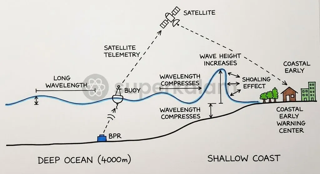
Phase velocity in deep water is determined by the shallow-water wave equation, where wave speed equals the square root of gravitational acceleration multiplied by water depth. At an average ocean depth of 4,000 metres, a tsunami propagates at velocities exceeding 700 to 800 kilometres per hour, matching the cruising speed of commercial jet aircraft. Because this immense energy is distributed across a massive wavelength, wave amplitude in the open ocean remains tiny—often measuring less than one metre—allowing vessels to ride past unnoticed.
Shoaling occurs when the high-speed wave approaches shallow coastal shelves and experiences severe bottom friction. Under the shoaling transformation governed by Green's Law, the total energy flux of the wave must be conserved.
As water depth decreases near shorelines, wave speed and wavelength compress sharply. To maintain constant energy transmission, wave amplitude increases inversely with the fourth root of water depth, converting hidden kinetic energy into towering, destructive coastal walls of water.
| Physical Parameter | Wind-Driven Surface Waves | Oceanic Tsunamis | Cyclonic Storm Surges |
|---|---|---|---|
| Primary Trigger | Atmospheric surface wind shear | Vertical seafloor or water displacement | Cyclone wind drag and low pressure |
| Water Column Involvement | Surface layer orbital decay | Entire water column (benthic to surface) | Shallow surface to mid-depth dome |
| Wavelength | 100 to 200 metres | 100 to 500 kilometres | Regional scale (100 to 500 kilometres) |
| Wave Period | 5 to 20 seconds | 10 minutes to 2 hours | Sustained over several hours |
| Open-Ocean Propagation Speed | 20 to 60 km/h | Exceeds 700 to 800 km/h | Corresponds to cyclonic track speed |
Discuss with Superkalam
Explain why tsunamis behave hydrodynamically as shallow-water waves even when travelling across 4,000-metre-deep ocean basins.
Ask NowHow Early Warning Networks Detect Threats Before Waves Reach Land
The Indian Tsunami Early Warning Centre at INCOIS operationalises deep-sea observation buoys and numerical hydrodynamic models to detect ocean floor anomalies. Established at the Indian National Centre for Ocean Information Services (INCOIS) in Hyderabad under the Ministry of Earth Sciences, the warning centre achieved full operational capability on 15 October 2007. The facility continuously monitors seismic and oceanographic data across the Indian Ocean basin to provide real-time hazard assessments.
Seafloor monitoring relies on Deep-ocean Assessment and Reporting of Tsunamis (DART) networks to detect the passage of tsunamis in real time. These installations feature Bottom Pressure Recorders (BPRs) deployed on the ocean floor, capable of measuring water column pressure changes as small as 1 millimetre. When an anomalous pressure signal is detected, the benthic recorder transmits acoustic telemetry to an anchored surface buoy. The buoy then relays real-time measurements via satellite to onshore monitoring stations.
Coastal sea-level confirmation is verified by coastal tide gauge networks operated jointly by INCOIS and the Survey of India. High-performance computing clusters run numerical hydrodynamic models that draw on pre-computed scenario databases. This infrastructure enables scientists to simulate arrival times, coastal run-up heights, and inundation boundaries within minutes of seismic detection.
The institutional alert matrix used by Indian authorities standardises emergency bulletins into three actionable categories:
- Warning (Red Alert): Issued when high-amplitude waves are forecast to strike; mandates immediate inland evacuation of coastal populations.
- Alert (Orange Alert): Forecasts moderate waves or strong coastal currents; instructs citizens to avoid beaches and harbours.
- Watch (Yellow Alert): Indicates mild or uncertain oceanic perturbations; requires district administrations to monitor updates without initiating public evacuation.
ITEWC is a designated Tsunami Service Provider (TSP) for the Indian Ocean basin alongside the Joint Australian Tsunami Warning Centre and Indonesia's InaTEWS under UNESCO-IOC oversight. INCOIS detects undersea earthquakes of magnitude 6.5 or greater and issues initial bulletins within 10 minutes of seismic rupture. In recognition of its technological excellence, INCOIS received the Subhash Chandra Bose Aapda Prabandhan Puraskar 2025 in the institutional category.
Modern early warning protocols mandate sea-level verification via DART buoys and tide gauges before authorities issue blanket inland evacuation orders. Relying solely on preliminary seismic magnitudes frequently produces false alarms, triggering public panic and economic disruption. Confirming genuine water column displacement ensures high credibility and prevents warning fatigue among coastal residents.
Discuss with Superkalam
How would you operationalise the institutional alert matrix (Red, Orange, Yellow) to manage harbor and beach safety during an offshore seismic event?
Ask NowThe Last-Mile Dilemma: Why Technology Fails Without Coastal Evacuation Protocols
Coastal disaster casualties persist when offshore telemetry fails to cross the last-mile gap during telecommunication collapses and power grid outages. While deep-sea buoys transmit oceanic readings within seconds, alerts often stall before reaching vulnerable artisanal fishing hamlets. Damaged cellular towers, vandalised warning sirens, and bureaucratic communication bottlenecks frequently sever the link between national forecasting centres and coastal villages.
Near-field tsunamis present an acute operational challenge where standard warning pipelines are structurally bypassed by physical geography. The September 2018 Palu earthquake and tsunami in Sulawesi, Indonesia, demonstrated this limitation when tsunami waves struck the coast within 3 minutes of tectonic rupture. Even a 10-minute warning bulletin arrives too late when coastal communities sit directly atop the rupture zone. Survival in near-field zones depends entirely on spontaneous community self-evacuation triggered by the physical sensation of severe ground shaking.
Community-level capacity building provides the only durable solution to this operational bottleneck. Odisha pioneered community empowerment by preparing coastal settlements to secure international Tsunami Ready recognition from UNESCO-IOC. In August 2020, the villages of Venkatraipur in Ganjam district and Noliasahi in Jagatsinghpur district became the first coastal communities across the entire Indian Ocean region to achieve this certification.
Community preparedness requires institutionalising several mandatory disaster readiness indicators:
- Community Evacuation Mapping: Mapping clear, signposted evacuation paths leading to elevated shelters above historical inundation levels.
- Public Awareness Campaigns: Educating coastal residents to identify natural warning signs, such as ground shaking and rapid shoreline water recession.
- Annual Evacuation Drills: Conducting regular simulations to verify that vulnerable elderly, disabled, and infant populations can reach safety within designated timelines.
- Redundant Alert Dissemination: Operating multi-channel communication systems, including battery-powered sirens, community megaphones, and satellite-linked radios.
As of September 2026, the Odisha State Disaster Management Authority has expanded this community resilience model to 100 coastal villages across six maritime districts. Empowering local disaster management committees ensures that early warnings trigger immediate evacuation, bridging the gap between scientific detection and community survival.
Discuss with Superkalam
Analyse the structural differences between cyclonic storm surges and seismic tsunamis with respect to wave generation, speed, and duration.
Ask NowNature's Shield: Why Mangroves and Coastal Ecology Remain Indispensable
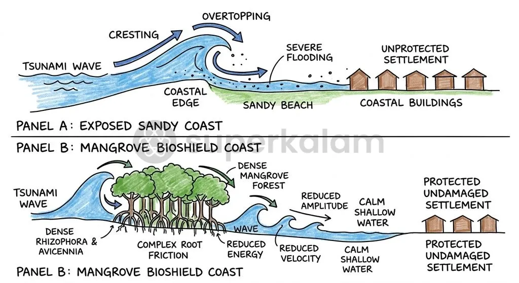
Mangrove ecosystems are living bioshields that physically dissipate incoming tsunami wave energy before surges strike inland coastal settlements. Field surveys following the 2004 tsunami documented that coastal villages shielded behind intact mangrove forests suffered substantially fewer casualties and structural losses than settlements along cleared shorelines. Dense coastal vegetation dampens turbulent flow velocities and establishes a dynamic hydraulic barrier.
Mangrove root systems mitigate incoming surges through targeted physical mechanisms:
- Hydrodynamic Drag via Prop Roots: Species such as Rhizophora develop vast networks of stilt and prop roots extending into the water column, creating formidable hydrodynamic drag against surging seawater.
- Energy Scattering via Pneumatophores: Stands of Avicennia produce thousands of vertical pneumatophores that force high-velocity wave energy to scatter through a maze of micro-channels.
- Momentum Extraction: This structural friction extracts momentum from advancing water, significantly decreasing both inland run-up depth and wave height.
Statutory protections safeguard these coastal ecological buffers from destructive urban encroachment. India's Coastal Regulation Zone (CRZ) Notification, 2019, issued under the Environment (Protection) Act, 1986, categorises ecologically sensitive coastal areas as CRZ-I. The regulation establishes non-negotiable No Development Zones (NDZ) along vulnerable coastal fringes. Enforcing these conservation buffers ensures that natural coastal wetlands remain intact to absorb storm surges and tsunami run-up.
Preserving ecological coastal barriers directly supports international commitments under the Sendai Framework for Disaster Risk Reduction 2015–2030. Specifically, Target G of the Sendai Framework directs signatory nations to substantially increase the availability of multi-hazard early warning systems and comprehensive coastal risk assessments by 2030. Integrating ecological infrastructure with physical sensor networks establishes a resilient, nature-based shield against catastrophic oceanic inundation.
Discuss with Superkalam
Weigh the relative efficacy of investing in automated deep-sea warning buoys versus ecological bioshields such as coastal mangroves for mitigating littoral risk.
Ask NowWay Forward: Closing the Gap Between Early Warning and Community Response
Sustained coastal resilience demands coupling high-precision ocean telemetry with institutionalised community drills and statutory conservation of marine ecological buffers. While technological upgrades have reduced warning generation timelines to minutes, true disaster mitigation requires aligning institutional capabilities with local readiness.
Key structural measures to strengthen coastal protection include:
- Nationwide Scale-Up of Tsunami Ready Programmes: Replicating Odisha's successful community framework across all maritime states and island territories, ensuring every vulnerable coastal settlement conducts regular evacuation drills and maintains clear escape routes.
- Hardening Last-Mile Communications: Installing redundant, off-grid alerting networks such as satellite-enabled coastal sirens and direct mobile broadcasts that operate independently of commercial power grids and cellular towers.
- Institutionalising Natural Warning Protocols: Training coastal populations to execute immediate self-evacuation upon observing natural indicators, such as intense ground motion or sudden shoreline recession, without waiting for official administrative broadcasts.
- Enforcing Coastal Regulation Zone Mandates: Strictly upholding No Development Zones under the CRZ Notification, 2019, preventing the reclamation of coastal wetlands and protecting mangrove habitats from commercial exploitation.
- Multi-Hazard Integration under Sendai Target G: Consolidating tsunami sensing networks into unified, multi-hazard early warning systems that monitor cyclonic storm surges, sea-level anomalies, and extreme weather events simultaneously.
Key Takeaways
- The 2004 Indian Ocean tsunami, caused by an Mw 9.1 to 9.3 megathrust earthquake along the Sunda subduction zone, prompted the creation of the UNESCO-IOC ICG/IOTWMS and India's Disaster Management Act, 2005.
- Tsunamis function hydrodynamically as shallow-water waves because their wavelengths (100 to 500 kilometres) vastly exceed ocean depths, propagating at speeds exceeding 700 to 800 kilometres per hour at depths of 4,000 metres.
- Under Green's Law of shoaling, tsunami wave speeds slow and wavelengths compress in shallow waters, dramatically elevating wave amplitudes to conserve total energy flux.
- The Indian Tsunami Early Warning Centre at INCOIS, Hyderabad, operational since 2007, combines DART bottom pressure recorders, tide gauges, and hydrodynamic models to deliver initial bulletins within 10 minutes of seismic detection.
- The last-mile dilemma proves that high-tech offshore sensors cannot prevent disaster without community-based evacuation protocols, as demonstrated by Odisha's Tsunami Ready villages and natural mangrove bioshields.
Mains Question
"The 2004 Indian Ocean tsunami exposed that offshore high-precision sensor architecture collapses if statutory governance and last-mile community evacuation fail." In light of the Disaster Management Act, 2005, evaluate India's transition from reactive relief to proactive coastal hazard governance. (15 Marks)
Evaluate NowMains Question
Differentiating between wind-driven surface waves and tsunamigenic wave trains, elucidate the hydrodynamic mechanism of shoaling governed by Green's Law as waves approach coastal shelves. (10 Marks)
Evaluate NowPractice MCQs
QUESTION 1
With reference to the physics and propagation of oceanic tsunamis, consider the following statements:
- Unlike wind-driven surface waves, tsunamis involve the coherent motion of the entire ocean water column from the benthic seafloor to the surface.
- In deep open ocean waters, tsunamis behave hydrodynamically as shallow-water waves because their wavelengths vastly exceed ocean basin depths.
- Under Green's Law of shoaling transformation, as a tsunami approaches the shoreline, its wave amplitude increases inversely with the fourth root of water depth.
Which of the statements given above are correct?
QUESTION 2
Consider the following statements regarding the Indian Tsunami Early Warning Centre (ITEWC):
- It was established under the Ministry of Earth Sciences at the Indian National Centre for Ocean Information Services (INCOIS), Hyderabad.
- It serves as a designated Tsunami Service Provider (TSP) for the Indian Ocean basin alongside warning centres in Australia and Indonesia under UNESCO-IOC oversight.
- It is engineered to detect undersea earthquakes of magnitude 6.5 or higher and issue initial advisory bulletins within 10 minutes of seismic rupture.
Which of the statements given above is/are correct?
QUESTION 3
Consider the following statements regarding the institutional alert matrix used by Indian disaster management authorities for tsunamis:
- A 'Warning' (Red Alert) mandates the immediate inland evacuation of coastal populations.
- An 'Alert' (Orange Alert) instructs coastal populations to avoid beaches and harbours due to moderate waves or strong currents.
- A 'Watch' (Yellow Alert) requires district administrations to proactively carry out public evacuations in anticipation of uncertain wave trains.
Which of the statements given above is/are correct?
QUESTION 4
Which of the following technological components is deployed on the ocean floor to detect tsunamis by measuring water column pressure differentials as minute as one millimetre?
QUESTION 5
Consider the following pairs regarding multi-hazard marine phenomena:
- Oceanic Tsunamis: Wave periods ranging from 10 to 120 minutes with open-ocean propagation speeds exceeding 700 km/h
- Wind-Driven Surface Waves: Disturbance confined to surface orbital decay with typical wave periods of 5 to 20 seconds
- Cyclonic Storm Surges: Impulsive gravitational wave trains triggered by elastic rebound along subduction faults
How many of the pairs given above are correctly matched?