Ocean Currents: Climate Drivers, AMOC Decline, and Monsoon Impacts
From shifting monsoon patterns to marine heatwaves, destabilised oceanic circulation is rapidly turning dynamic global currents into active climate hazards.
Nov, 2026
•16 min read
Overview
Global ocean currents are the primary planetary climate engine. They redistribute immense solar thermal energy from equatorial regions toward polar sinks. This heat transfer operates through coupled wind-driven surface gyres and deep density-powered thermohaline circulation systems across thousand-year cycles.
According to the Intergovernmental Panel on Climate Change (IPCC), anthropogenic warming is destabilising this planetary machinery, with more than 90% of excess climate system heat absorbed by global oceans. This structural heating suppresses vertical mixing, intensifies marine heatwaves, and decelerates key circulation limbs like the Atlantic Meridional Overturning Circulation (AMOC).
For India, these shifts are not distant polar concerns. Destabilised oceanic circulation alters global thermal balances and directly disrupts the South Asian monsoon. This shift transforms ocean currents from dependable climate regulators into active drivers of regional ecological and economic vulnerability.
Why Ocean Circulation Is Back in the Climate Spotlight
Ocean circulation is now a central flashpoint in climate science because planetary heat accumulation directly alters deep oceanic kinetic energy. According to the IPCC Sixth Assessment Report (AR6), global oceans have absorbed over 90% of excess heat trapped within the Earth system by greenhouse gas emissions.
Key physical shifts driving ocean circulation into the spotlight include:
- Accelerating vertical stratification: Severe thermal uptake prevents the normal exchange of heat, oxygen, and nutrients between surface layers and the abyss.
- Proliferating marine heatwaves: The IPCC AR6 confirms with high confidence that marine heatwaves approximately doubled in frequency across the globe between 1982 and 2016, with 84% to 90% of observed occurrences attributable to human-induced ocean warming.
- Altering circulation pathways: As of October 2024, oceanographic assessments highlight that this warming disrupts long-established currents, threatening the Atlantic Meridional Overturning Circulation (AMOC) as a primary heat pump for the Northern Hemisphere.
Decelerating currents disrupt marine habitats and alter terrestrial precipitation patterns. For public policy and civil services preparation, ocean dynamics are no longer static physical geography; they represent an active driver of environmental volatility, disaster management challenges, and blue-economy risks.
Discuss with Superkalam
What percentage of global capture fisheries yields is supplied by Eastern Boundary Upwelling Systems (EBUS)?
Ask NowHow Wind, Heat, and Salinity Power the Global Conveyor Belt
Ocean water movement is governed by a balance of primary driving forces and secondary density gradients. Primary forces initiate water motion, whereas secondary forces control the direction and vertical structure of the flow.
| Primary Driving Force | Physical Mechanism | Dynamic Effect on Oceans |
|---|---|---|
| Solar Heating | Unequal insolation causes equatorial water expansion | Generates a subtle poleward dynamic height gradient |
| Wind Friction | Trade winds and Westerlies drag surface layers | Drives water into five dynamic subtropical gyres |
| Coriolis Deflection | Earth's rotation diverts fluid motion rightwards in NH, leftwards in SH | Produces a 90-degree net mass transport (Ekman transport) |
As detailed in NCERT Class 11 physical geography frameworks, the primary drivers comprise four integrated mechanisms:
- Solar heating: Unequal insolation causes equatorial waters to expand, creating an oceanic surface dynamic height difference that slopes gently toward the poles.
- Planetary wind friction: Trade winds drive surface waters westward in equatorial bands, while mid-latitude westerlies push waters eastward, transferring kinetic momentum to ocean basins.
- Gravity: Gravity pulls water down dynamic topography gradients created by wind pile-ups.
- Coriolis deflection: Earth's planetary rotation exerts an apparent force that deflects moving fluid parcels. According to the NOAA National Ocean Service, the Coriolis force deflects currents to the right of the wind vector in the Northern Hemisphere and to the left in the Southern Hemisphere, producing a net 90-degree mass transport known as Ekman transport.
Planetary wind fields and continental barriers guide surface currents into five major subtropical oceanic gyres: the North Atlantic, South Atlantic, North Pacific, South Pacific, and South Indian gyres. Continental boundaries deflect zonal flows poleward along western margins as fast, narrow western boundary currents, such as the Gulf Stream and Kuroshio. Conversely, return flows move equatorward along eastern margins as broad, shallow, and sluggish eastern boundary currents, such as the California and Canary currents.
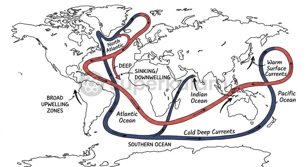
Beneath the wind-driven surface layer sits the thermohaline circulation, commonly described as the Global Conveyor Belt. According to the NASA Earth Observatory, this deep circulation is powered by density differentials governed by seawater temperature (thermo) and salinity (haline). In subpolar basins, surface waters chill under Arctic winds and gain density as sea ice formation expels salt. These dense waters sink into the ocean abyss, initiating a planetary journey that takes roughly 1,000 years to circulate through global basins before resurfacing via diffuse upwelling.
| Feature / Dimension | Surface Ocean Currents | Thermohaline Circulation (Deep Conveyor) |
|---|---|---|
| Primary Driver | Planetary winds (Trade winds, Westerlies) and Coriolis force | Density variations caused by temperature and salinity gradients |
| Depth of Operation | Upper 10% of oceanic volume (typically top 400 metres) | Lower 90% of oceanic volume (ocean interior and abyss) |
| Flow Velocity | Fast; frequently exceeds 1 to 2 metres per second in western boundary currents | Sluggish; typical velocities range from centimetres to millimetres per second |
| Overturning Timescale | Days to months across regional basin basins | Approximately 1,000 years for a full planetary loop |
| Core Earth System Role | Regional climatic moderation and coastal weather modulation | Planetary vertical heat storage and long-term carbon sequestration |
Discuss with Superkalam
How does the interaction between planetary winds and the Coriolis force produce Ekman transport in the ocean?
Ask NowHow Ocean Currents Regulate Regional and Global Climates
The Atlantic Meridional Overturning Circulation operates as a colossal planetary radiator, moving warm tropical surface waters northward while returning cold deep water southward. According to the IPCC AR6 (Working Group I, Chapter 9), the AMOC transports approximately 1.25 petawatts of heat northward into the subpolar Atlantic. This continuous heat transfer prevents Western and Northwestern Europe from experiencing the subarctic climates typical of equivalent latitudes in North America.
Proximity to warm currents substantially alters coastal thermal regimes. As documented in NCERT Class 11 geography, the North Atlantic Drift—the northeastward continuation of the Gulf Stream—transfers maritime warmth across the eastern Atlantic basin. This warm water transfer keeps Norwegian and Northwestern European ports entirely ice-free year-round up to 70 degrees North latitude. In sharp contrast, North American settlements along the Labrador coast at identical latitudes remain locked in pack ice for months due to the chilling influence of the subpolar Labrador Current.
Cold currents moving from polar regions toward the equator exert a powerful desiccation effect on adjacent continental borders through a structured atmospheric sequence:
- Advection of cold surface water: A subpolar current sweeps along a subtropical continental western margin.
- Lower air mass cooling: The frigid current cools the bottom layer of incoming maritime air.
- Thermal inversion formation: A persistent thermal inversion layer develops, trapping cool, dense air below warmer, lighter air.
- Convective suppression: The inversion halts vertical convective updrafts, preventing cloud formation and creating extreme aridity.
The resulting atmospheric stability strips coastal lands of moisture, directly sustaining major west-coast subtropical deserts:
- The Atacama Desert in South America, desiccated by the cold Humboldt (Peru) Current.
- The Namib Desert in southwestern Africa, maintained by the cold Benguela Current.
- The coastal tracts of the Sahara Desert, reinforced by the cold Canary Current.
Discuss with Superkalam
If sea surface temperatures continue to rise rapidly in subpolar basins, how would this alter deep water formation and the 1,000-year thermohaline loop?
Ask NowThe Nutrient Engine: Why Convergence Zones and Upwelling Drive World Fisheries
The biological productivity of marine ecosystems depends on the replenishment of nitrates, phosphates, and silicates in the sunlit photic zone. Cold, deep ocean waters are rich in dissolved nutrients, derived from decomposed organic matter that has settled into the depths. Where physical forces lift these deep waters or blend water masses of contrasting origins, marine food webs flourish.
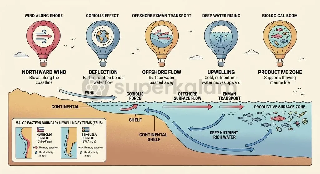
According to the Food and Agriculture Organization (FAO Fisheries and Aquaculture Technical Paper No. 627), Eastern Boundary Upwelling Systems (EBUS) occupy less than 2% of the total ocean surface area yet supply over 20% of global marine capture fisheries yields. These upwelling zones are powered by alongshore winds interacting with the Coriolis force:
- Alongshore planetary winds blow equatorward along eastern ocean boundaries.
- The Coriolis force deflects surface waters offshore via Ekman transport.
- This offshore movement pulls cold, nutrient-saturated deep water up to replace it.
- Intense sunlight in the photic zone triggers massive blooms of phytoplankton, sustaining rich trophic chains of zooplankton, forage fish, and apex marine predators.
The four classic EBUS regimes comprise the Humboldt Current off Peru and Chile, the Benguela Current off southwestern Africa, the Canary Current off northwestern Africa, and the California Current off North America.
A second mechanism of biological concentration occurs at current convergence zones, where warm and cold flows collide. When a warm current encounters a cold, nutrient-laden polar current, the mixing of mineral salts, varied thermal properties, and oxygen creates an optimal nursery for planktonic growth.
The collision of the warm Gulf Stream with the cold Labrador Current off Newfoundland forms the legendary fishing grounds of the Grand Banks. Similarly, in the northwest Pacific, the convergence of the warm Kuroshio Current and the frigid Oyashio Current off the coast of Japan creates one of the most prolific commercial fishing zones in the world.
| Marine System / Region | Converging Currents or System Mechanism | Ecological & Commercial Impact | Primary Economic Catch |
|---|---|---|---|
| Grand Banks (Northwest Atlantic) | Cold Labrador Current meets warm Gulf Stream | Dense plankton blooms; persistent sea fogs form navigational hazards | Historically cod, haddock, and diverse groundfish |
| Sea of Japan / Northwest Pacific | Cold Oyashio Current collides with warm Kuroshio Current | Mixing zone creates high primary biological productivity across thermal fronts | Pacific saury, sardines, squid, and mackerel |
| Peruvian Upwelling Shelf (Humboldt) | Wind-driven Ekman transport diverts Humboldt surface water offshore | The world's most productive Eastern Boundary Upwelling System | Peruvian anchoveta (Engraulis ringens) for global fishmeal |
| Benguela Ecosystem (South Atlantic) | Alongshore winds drive coastal upwelling of cold South Atlantic central water | High biomass yield supporting southern African coastal economies | Cape hake, pilchards, and pelagic schooling fish |
Discuss with Superkalam
Weigh the relative significance of wind friction versus thermohaline density gradients in maintaining global climate equilibrium.
Ask NowMarine Heatwaves and Weakening Currents: What IPCC AR6 Warns About Tipping Points
Anthropogenic carbon emissions cause widespread shifts across the physical oceanography of the subpolar North Atlantic. The IPCC Sixth Assessment Report (Working Group I, Chapter 9) concludes with high confidence that the AMOC is very likely to decline over the 21st century across all Shared Socioeconomic Pathways (SSPs). However, the IPCC maintains medium confidence that an outright collapse will not occur before 2100.
The primary physical trigger behind this deceleration is the freshening and warming of high-latitude surface waters. Accelerated melting of the Greenland Ice Sheet alongside thinning Arctic sea ice discharges vast volumes of low-density freshwater into the subpolar North Atlantic. This influx dilutes seawater salinity, lowering its density. As a result, surface waters lose the negative buoyancy required to sink, weakening the convective engine that pulls the upper limb of the AMOC northward.
A slowing AMOC destabilises the broader planetary climate through a five-step teleconnection sequence:
- High-latitude freshening: Cryosphere melt and atmospheric warming discharge low-density freshwater into the subpolar North Atlantic.
- Suppression of deep sinking: Diluted surface water loses negative buoyancy, directly slowing convective sinking and weakening the AMOC.
- Inter-hemispheric thermal asymmetry: The Northern Hemisphere cools relative to the rapidly warming Southern Hemisphere as northward heat transport drops.
- Southward shift of the ITCZ: Atmospheric convective belts migrate toward the warmer hemisphere, displacing the Intertropical Convergence Zone (ITCZ) southward.
- Monsoon disruption: The cross-equatorial pressure gradient weakens, reducing summer monsoon rainfall over South Asia.
Simultaneously, the upper ocean experiences escalating thermal stratification. With over 90% of excess heat absorbed by surface waters, the density difference between surface and deeper layers has intensified. This stratification forms a physical barrier that prevents vertical mixing. It starves surface waters of sub-surface nutrients while depriving deeper ecosystems of dissolved oxygen, pushing dynamic currents toward stratified, oxygen-depleted tipping points.
Discuss with Superkalam
Given the disruption to oceanic heat transfer and the South Asian monsoon, outline a framework for coastal disaster mitigation and ocean health monitoring for India.
Ask NowSocio-Economic Risks for Coastal Nations and India's Blue Economy
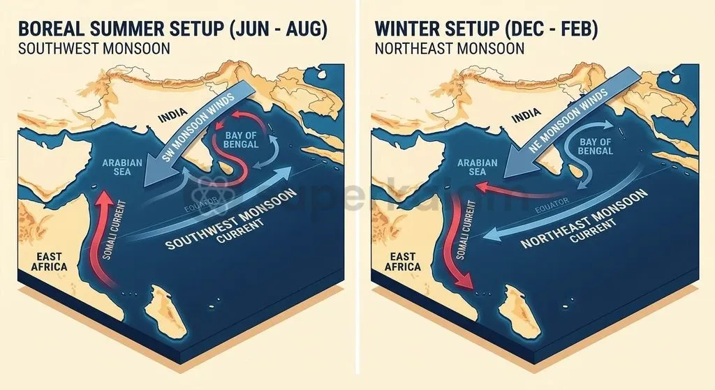
The Indian Ocean features a unique geographic boundary: it is landlocked to the north by the Asian landmass, preventing cold polar ventilation. As established in NCERT Class 11 physical geography, this configuration makes the North Indian Ocean the only ocean basin on Earth whose surface circulation completely reverses semi-annually. Driven by seasonal reversals of monsoon winds, the system alternates between the eastward Southwest Monsoon Current during boreal summer and the westward Northeast Monsoon Current during boreal winter.
During the summer monsoon, the Somali Current develops along the Horn of Africa as a swift seasonal western boundary current, with surface speeds exceeding 2 metres per second. This current induces intense coastal upwelling of cold waters (17–22°C) off Somalia and Arabia, pulling up nutrients that drift into the central Arabian Sea.
Similarly, wind-driven coastal upwelling develops along India's southwest Malabar shelf. Data from the Central Marine Fisheries Research Institute (ICAR-CMFRI) indicates that this seasonal upwelling elevates primary chlorophyll concentrations, supporting India's primary pelagic capture fisheries. These coastal waters are dominated by the Indian oil sardine (Sardinella longiceps) and the Indian mackerel (Rastrelliger kanagurta).
| Regional Driver | Oceanographic Mechanism | Socio-Economic & Marine Impact |
|---|---|---|
| North Indian Ocean Reversal | Semi-annual monsoon wind reversals switch flow eastward in summer and westward in winter | Dictates seasonal regional navigation and coastal current patterns |
| Somali & Malabar Upwelling | Seasonal alongshore winds bring cold (17–22°C), nutrient-rich water to photic zones | Supports major pelagic fish stocks, including oil sardines and mackerel |
| Tropical Basin Warming | Rapid thermal absorption triggers frequent Arabian Sea marine heatwaves | Weakens upwelling windows, driving stock shifts and threatening 4 million coastal fishers |
Accelerated warming in the tropical Indian Ocean now threatens this seasonal balance:
- Disrupted upwelling windows: Altered wind patterns and surface warming weaken seasonal upwelling, reducing nutrient concentrations in nearshore waters.
- Fish stock redistribution: CMFRI field assessments track sardine schools moving away from traditional southern Malabar waters toward northern and deeper offshore shelves in search of cooler habitats.
- Fisheries livelihood precarity: Shifting catch compositions and sudden stock collapses threaten India's marine fisheries sector, which supports over 4 million coastal fishers and allied workers.
- Extreme cyclones: Excessive ocean heat content in the Arabian Sea accelerates cyclone intensification, causing coastal damage and disrupting traditional fishing cycles.
Recognising these deep-sea challenges, India has stepped up strategic and technological commitments to ocean exploration. The Cabinet Committee on Economic Affairs (CCEA) approved India's Deep Ocean Mission at a total estimated cost of ₹4,077 crore over a five-year period, with the Ministry of Earth Sciences (MoES) serving as the nodal agency.
Under the mission's flagship Samudrayaan initiative, the National Institute of Ocean Technology (NIOT) is developing MATSYA 6000, an indigenous three-person manned submersible rated for operation at a depth of 6,000 metres. This technology gives India the capability to monitor deep-water physical parameters, survey benthic ecosystems, and study the mineral-rich ocean bed.
Way Forward: Monitoring Ocean Health and Strengthening Ocean Governance
The High Seas Treaty provides a comprehensive international architecture for governing international waters beyond sovereign limits. On July 2, 2024, the Union Cabinet approved India's signing of the Biodiversity Beyond National Jurisdiction (BBNJ) Agreement under the United Nations Convention on the Law of the Sea (UNCLOS). India formally signed the treaty at the United Nations headquarters on September 25, 2024.
As codified under the United Nations Treaty Collection, the BBNJ Agreement establishes a legally binding multilateral regime based on four key pillars for areas beyond the 200-nautical-mile Exclusive Economic Zone (EEZ):
- Marine Genetic Resources (MGRs): Establishing mechanisms for the fair and equitable sharing of scientific and commercial benefits derived from deep-sea genetic materials.
- Area-Based Management Tools (ABMTs): Providing a legal process to create Marine Protected Areas (MPAs) in international waters, safeguarding vital current systems and biodiversity corridors.
- Environmental Impact Assessments (EIAs): Setting clear standards for assessing the environmental impacts of commercial activities on the high seas.
- Capacity Building and Marine Technology Transfer: Directing scientific infrastructure, data-sharing pipelines, and research capabilities toward developing coastal states.
To turn international ocean commitments into actionable policy, nations must combine multilateral agreements with dedicated operational oceanography:
- Expanding continuous observational arrays: Ocean monitoring requires sustained investment in autonomous Argo floats, moored deep-ocean acoustic arrays, and satellite altimetry. These systems are essential for detecting early shifts in the AMOC and tracking changing conditions across the Indian Ocean dipole.
- Mainstreaming marine heatwave forecasting: Operational meteorology centres, including the Indian National Centre for Ocean Information Services (INCOIS), need to integrate real-time marine heatwave advisories into coastal disaster management programmes.
- Adopting dynamic fisheries management: Maritime states must adjust their seasonal fishing bans in response to changing upwelling timelines and shifting fish migrations, moving away from static calendar dates.
- Coordinating through global scientific frameworks: Coastal countries should align their research programmes with the UN Decade of Ocean Science for Sustainable Development (2021–2030), supporting equitable technology transfers and international research in areas beyond national jurisdiction.
Key Takeaways
- Dual Circulation Engines: Ocean circulation runs on wind-driven surface currents organised into five subtropical gyres, alongside a 1,000-year thermohaline conveyor belt powered by temperature and salinity density gradients.
- Planetary Thermal Moderation: The AMOC transfers 1.25 petawatts of heat into the subpolar North Atlantic, keeping Northwestern European ports ice-free up to 70°N, while cold currents create thermal inversion layers that sustain coastal deserts like the Atacama and Namib.
- Biological and Fisheries Centres: Eastern Boundary Upwelling Systems (EBUS) cover less than 2% of the ocean's surface yet produce over 20% of global marine capture fisheries. Major convergence zones, like the Grand Banks, rely on plankton blooms supported by colliding currents.
- IPCC AR6 Climate Warnings: AMOC decline over the 21st century is considered very likely across all emission pathways (high confidence), while marine heatwaves doubled in frequency between 1982 and 2016, with up to 90% linked to anthropogenic heating.
- South Asian Monsoon Teleconnections: Freshwater runoff from the melting Greenland Ice Sheet dilutes North Atlantic salinity and slows convective sinking. This displaces the ITCZ southward, weakening cross-equatorial pressure gradients and reducing summer monsoon rains over South Asia.
- India's Strategic Response: India formally signed the UNCLOS BBNJ High Seas Treaty on September 25, 2024, to protect biodiversity in international waters. Domestically, the Ministry of Earth Sciences is advancing the ₹4,077 crore Deep Ocean Mission, including NIOT's 6,000-metre submersible MATSYA 6000.
Mains Question
"According to the IPCC AR6, the Atlantic Meridional Overturning Circulation (AMOC) transports approximately 1.25 petawatts of heat northward, acting as a planetary radiator." Elucidate the mechanisms through which ocean currents regulate regional climates and examine the climatic consequences of their weakening. (15 Marks)
Evaluate NowMains Question
"Eastern Boundary Upwelling Systems occupy less than 2% of the ocean surface area yet supply over 20% of global marine capture fisheries yields." Examine the physical dynamics governing these systems and the risks posed to them by anthropogenically driven ocean stratification. (10 Marks)
Evaluate NowPractice MCQs
QUESTION 1
Consider the following statements regarding ocean circulation systems:
- Surface ocean currents are primarily driven by planetary winds and Coriolis deflection, operating in the upper 10% of oceanic volume.
- Thermohaline circulation operates in the lower 90% of oceanic volume and takes approximately 1,000 years for a full planetary loop.
- The Coriolis force deflects currents to the left in the Northern Hemisphere and to the right in the Southern Hemisphere, causing net Ekman transport. Which of the statements given above are correct?
QUESTION 2
With reference to Eastern Boundary Upwelling Systems (EBUS), consider the following statements:
- EBUS occupy less than 2% of the total ocean surface area but supply over 20% of global marine capture fisheries yields.
- Upwelling in these zones is initiated when alongshore planetary winds interact with Coriolis deflection to drive surface waters offshore via Ekman transport.
- The Gulf Stream and the Kuroshio Current are two prominent examples of Eastern Boundary Upwelling Systems. Which of the statements given above is/are correct?
QUESTION 3
Consider the following pairs of deserts and the associated ocean currents contributing to their aridity:
- Atacama Desert — Humboldt Current
- Namib Desert — Benguela Current
- Coastal Sahara Desert — Canary Current How many of the pairs given above are correctly matched?
QUESTION 4
Consider the following statements regarding the findings highlighted by the IPCC Sixth Assessment Report (AR6):
- Global oceans have absorbed more than 90% of the excess heat trapped within the Earth system by greenhouse gas emissions.
- Marine heatwaves approximately doubled in frequency across the globe between 1982 and 2016, with 84% to 90% attributable to human-induced warming. Which of the statements given above is/are correct?
QUESTION 5
The North Atlantic Drift keeps Norwegian and Northwestern European ports ice-free year-round up to which of the following latitudes?