Antecedent Drainage: Why Himalayan Rivers Cut Deep Gorges
Trans-Himalayan rivers predate the mountains they traverse, cutting massive bedrock gorges by matching tectonic uplift with relentless vertical downcutting.
Nov, 2026
•11 min read
Overview
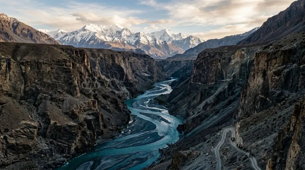
An antecedent river system is a drainage network established before tectonic crustal deformation. It preserves its original flow trajectory across an uplifting mountain barrier by matching or exceeding rock uplift through vertical bedrock incision.
According to NCERT Class XI: India: Physical Environment, Chapter 3 (Drainage System), major trans-Himalayan channels—including the Indus, Sutlej, and Brahmaputra—predate the Higher Himalayan ranges. Rather than deflecting around rising folds, these rivers sustained their paths by cutting deep clefts through crystalline bedrock.
This geomorphic mechanism explains why northern India's primary rivers dissect the highest topography on Earth. In doing so, they concentrate extreme fluvial stream power that triggers severe slope instability and disaster risks for modern infrastructure.
Why Do Himalayan Rivers Flow Across the World's Highest Ranges?
The Himalayan river system defies ordinary drainage patterns. Major rivers like the Indus, Sutlej, and Brahmaputra flow directly across the highest crystalline crests of the Great Himalayan Range. Standard fluvial models assume rivers originate along primary drainage divides at peak elevations and descend along regional slopes.
As of March 2026, field mappings by the Geological Survey of India confirm that major Himalayan waterways originate north of the highest snow-clad crests on the arid southern Tibetan plateau. These channels cut directly through the mountain chain rather than flowing away from it. This geometry stems from two fundamental geomorphic phases:
- Pre-uplift establishment: Ancient river courses flowed southward across the landmass long before the main tectonic pulses elevated the Greater Himalayas.
- Incision-uplift equilibrium: As regional crust compressed upward, the rivers focused mechanical energy downward, incising deep vertical gorges at a rate matching tectonic uplift.
This continuous balance produced distinctive transverse river valleys that slice through structural folds at nearly right angles. The resulting landforms turn the Himalayas into an active natural laboratory for tectonic geomorphology.
Discuss with Superkalam
Which major trans-Himalayan rivers originated north of the Great Himalayan crest before the main mountain uplift occurred?
Ask NowWhat Is an Antecedent River System?
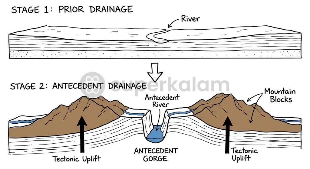
An antecedent drainage network forms when a pre-existing river incises its channel at a rate equal to or faster than local tectonic uplift, preserving its original course across new mountain ridges. The defining characteristic of an antecedent stream is its temporal priority over the structural relief across which it flows.
A river maintains an antecedent course across an uplifting terrain only if its vertical downcutting rate matches or exceeds the crustal uplift rate. If downcutting falls behind, the channel is deflected, ponded, or diverted into longitudinal valleys. This dynamic balance hinges on specific hydraulic and structural variables:
- Vertical downcutting rate ($E$): The speed at which sediment tools and high hydraulic head excavate the bedrock channel floor.
- Tectonic uplift rate ($U$): The rate at which active structural thrusts push rock masses upward toward the surface.
- Equilibrium condition ($E \ge U$): The prerequisite where downcutting prevents the rising rock from damming or redirecting the fluvial channel.
- Deflection threshold ($E < U$): The failure state where tectonic uplift outstrips erosion, forcing the river into parallel structural depressions or creating intermontane lakes.
Fluvial incision operates primarily through mechanical abrasion, hydraulic plucking, and cavitation. Coarse sediment loads carried by steep mountain torrents grind away the bedrock floor like industrial drill bits. Because base level remains fixed to the low-lying plains, tectonic uplift steepens local channel gradients, accelerating stream velocity and sharpening canyon profiles.
Comparison: Antecedent Drainage vs Superimposed Drainage
The Peninsular Indian shield and the Himalayan orogen exhibit contrasting drainage styles known as superimposed and antecedent systems, reflecting distinct structural histories across geological time. Both drainage types are discordant, meaning their flow paths disregard the structural grain, folds, and fault alignments of the surrounding bedrock. However, their genetic origins and evolutionary mechanisms differ fundamentally.
Antecedent drainage develops when a river predates the tectonic uplift that deforms the land across its course. By contrast, superimposed (or epigenetic) drainage develops when a stream establishes its original dendritic or meandering course on an overlying cover of younger horizontal strata or soft alluvium.
Over millions of years, the river cuts downward through this superficial blanket, eventually uncovering older, structurally complex, and deformed basement rocks beneath. Once locked into these discordant underlying formations, the river continues cutting through hard ridges and folded strata along its inherited path.
| Comparative Dimension | Antecedent Drainage System | Superimposed Drainage System |
|---|---|---|
| Temporal Relationship | Stream network predates tectonic deformation of the mountain barrier | Stream network predates the exhumation of buried underlying structures |
| Primary Driver | Active tectonic uplift countered by continuous vertical river incision | Regional denudation stripping younger strata to reveal older discordances |
| Structural Setting | Actively deforming orogens, thrust belts, and rising anticlines | Geologically stable shields, cratons, and eroded sedimentary covers |
| Diagnostic Landforms | Narrow V-shaped gorges, knickpoints, unpaired terraces, hanging valleys | Water gaps, incised meanders, epigenetic gorges across hard ridges |
| Indian Examples | Indus, Sutlej, Brahmaputra, Arun, Subansiri | Damodar, Subarnarekha, Son, Chambal |
Peninsular rivers like the Damodar and Subarnarekha demonstrate superimposed patterns across the ancient Chota Nagpur Plateau. These channels developed on younger covers before eroding down onto resistant Precambrian crystalline basements. Conversely, the great Himalayan rivers directly cut across actively rising tectonic folds, illustrating true antecedent incision.
Discuss with Superkalam
Why do antecedent rivers cut narrow V-shaped gorges through rising rock rather than being diverted around high peaks?
Ask NowHow the Collision of Indian and Eurasian Plates Drove River Incision
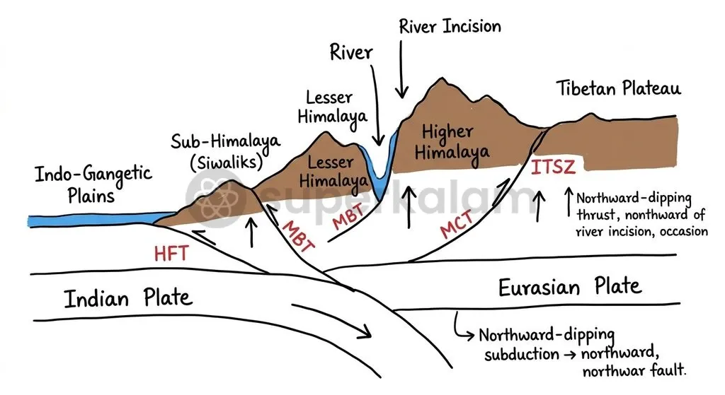
The continental collision between the Indian Plate and the Eurasian Plate approximately 50 to 55 million years ago initiated the Himalayan orogeny across pre-existing river networks. According to the Geological Survey of India, Miscellaneous Publication No. 30: Geology and Mineral Resources of the States of India, this early Paleogene plate convergence consumed the intervening Neo-Tethys oceanic lithosphere. As the northern edge of the Indian shield subducted beneath southern Eurasia, sequential orogenic pulses folded and faulted the crust.
Tectonic compression produced three primary structural dislocations spanning northern India:
- The Main Central Thrust (MCT), bringing High Himalayan crystalline rocks over Lesser Himalayan metasediments.
- The Main Boundary Thrust (MBT), separating Lesser Himalayan sedimentary belts from the Sub-Himalayan Siwalik molasse.
- The Himalayan Frontal Thrust (HFT), demarcating the southernmost structural boundary against the Indo-Gangetic alluvium.
Before these thrust sheets attained their present elevations, an ancient south-flowing drainage network drained runoff from proto-Tibetan highlands toward the ocean. As regional crustal shortening hoisted the Greater Himalayan crystalline core upward, it encountered these entrenched river courses.
The trans-Himalayan rivers did not deflect or pool behind the rising mountains. Instead, rapid structural uplift steepened local hydraulic gradients. This steepening granted rivers the mechanical cutting power required to slice through resistant granites and gneisses along narrow tectonic fractures.
Deep Gorges and Knickpoints: Key Geomorphic Evidence Along Indus, Sutlej, and Brahmaputra
The Indus, Kali Gandaki, and Brahmaputra rivers display monumental bedrock gorges, knickpoints, and terraces that provide definitive field evidence of continuous antecedent incision through the Himalayas. A knickpoint represents an abrupt vertical drop or steepening along a river's longitudinal profile, marking a transient boundary where active incision propagates upstream. Unpaired river terraces and hanging tributary valleys further confirm that trunk channels cut down far faster than their lateral valleys could widen.
Geologists have documented world-renowned examples of these antecedent landforms across the Himalayan arc:
- Indus Gorge at Nanga Parbat: The Indus River cuts a transverse antecedent gorge between 4,500 and 5,200 metres deep near the Nanga Parbat massif where the river circumvents the western syntaxial bend of the Himalayas. This chasm represents one of the deepest land canyons on the planet.
- Kali Gandaki Gorge: Carving between the eight-thousander massifs of Dhaulagiri (8,167 m) and Annapurna I (8,091 m) in central Nepal, the Kali Gandaki River cuts an antecedent chasm exceeding 5,500 metres in vertical relief.
- Yarlung Tsangpo Grand Canyon: The Yarlung Tsangpo cuts an antecedent canyon dropping over 2,000 metres across the eastern syntaxial bend around the Namcha Barwa peak (7,782 m), reaching depths exceeding 5,000 metres before entering Arunachal Pradesh as the Siang/Dihang.
- Arun River Valley: The Arun River, the principal antecedent tributary of the Kosi river system, originates in Tibet north of the High Himalayas as the Phung Chu and traverses the Great Himalayan crystalline crest via an antecedent transverse valley east of Mount Everest.
- Subansiri Gorge: The Subansiri River maintains an antecedent transverse gorge through the crystalline eastern Greater Himalayas, rising in the Tibetan plateau near Mount Porong and cutting across Arunachal Pradesh into the Brahmaputra valley.
These colossal clefts expose complete structural cross-sections of the Himalayan crust. Their sheer bedrock profiles and narrow floors prove that vertical erosion continuously outpaced valley-widening hillslope processes throughout the Quaternary epoch.
Discuss with Superkalam
How do the structural origins of the Damodar on the Chota Nagpur Plateau differ from those of the Kali Gandaki in the Himalayas?
Ask NowDrainage Evolution: How River Capture and Faulting Reshaped South Asian Basins
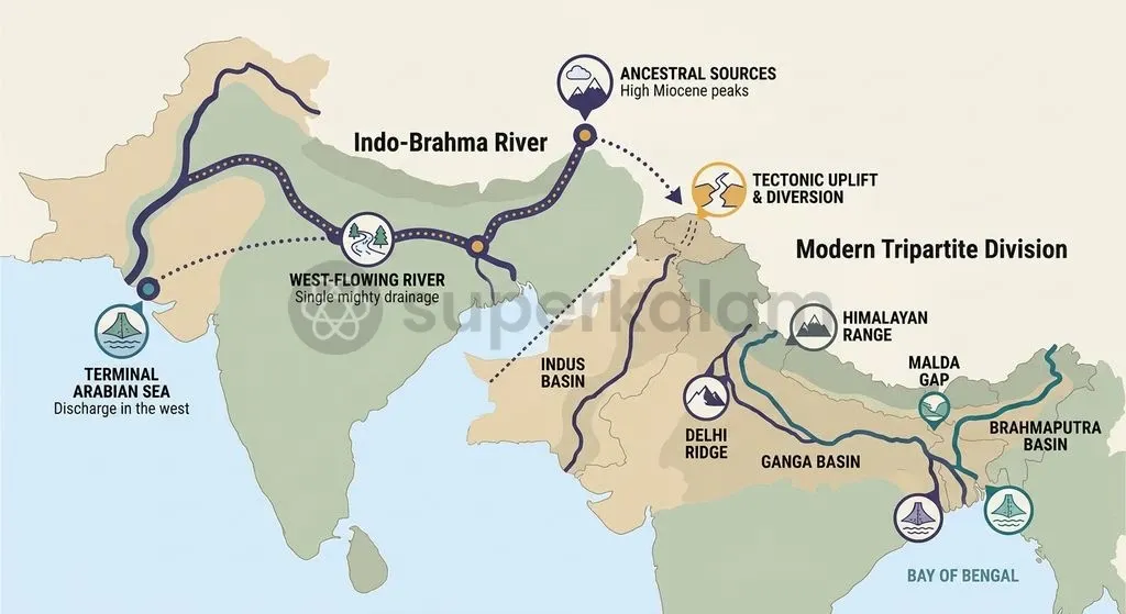
The Indo-Brahma river hypothesis formulated by E.H. Pascoe and G.E. Pilgrim proposed that a single major trans-Himalayan channel previously drained northern India into the Arabian Sea. In 1919, Pascoe and Pilgrim postulated that a single continuous Miocene river flowed west-northwest from Assam along the Himalayan foothills into the Arabian Sea before being dismembered into three systems during the Pleistocene epoch.
Two distinct structural movements drove this drainage reorganisation:
- Potwar Plateau uplift: Pleistocene tectonic uplift of the Delhi Ridge-Potwar divide severed the continuous flow, diverting western waters to the Arabian Sea via the Indus and turning central drainages eastward toward the Bay of Bengal.
- Malda Gap subsidence: Down-faulting of the Garo-Rajmahal gap opened an outlet southward, allowing the Ganga and Brahmaputra to join and empty into the Bay of Bengal.
Concurrently, intense headward erosion by high-gradient southern Himalayan streams drove persistent river captures. These streams breached regional watersheds across the Main Central Thrust (MCT) and Main Boundary Thrust (MBT), annexing low-gradient Tibetan longitudinal drainages. South-flowing torrents, fed by heavy monsoon rains on the southern slopes, cut relentlessly northward into the arid Tibetan plateau.
Key physical markers document this progressive drainage capture:
- Headward watershed breaching: Steep southern streams cut across major thrust faults to intercept ancient Tibetan trunk lines.
- Barbed drainage networks: Tributaries join trunk channels at upstream-pointing obtuse angles along the Yarlung Tsangpo in southern Tibet, providing direct evidence of flow reversal.
As south-flowing transverse channels breached the structural axis, they pirated east-flowing Tibetan waters, fundamentally reorganising regional drainage across South Asia.
Discuss with Superkalam
How critical is the condition E >= U in determining whether an uplifting structural belt develops deep transverse gorges or an intermontane lake basin?
Ask NowWhy Himalayan River Dynamics Matter for Infrastructure and Hydropower Safety
Infrastructure projects in antecedent Himalayan gorges face severe geohazards. Steep valley walls, active faulting, and heavy sediment loads create persistent engineering risks. The very mechanical energy that allowed these rivers to saw through uplifting mountain ranges makes their narrow corridors precarious. Consequently, constructing linear infrastructure, tunnels, and dams demands rigorous geomorphic accounting.
Engineering planners face four critical structural challenges in these active transverse corridors:
- Extreme stream power: High-gradient knickpoints concentrate hydraulic energy, driving deep bedrock incision and destabilising canyon flanks to trigger destructive rockfalls.
- Landslide dams and outburst floods: Steep, narrow canyon profiles create natural choke points where mass wasting dams high-velocity rivers. These blockages form temporary Landslide Dammed Lakes (LLOFs) and Glacial Lake Outburst Floods (GLOFs) that unleash catastrophic flash floods upon breaching.
- Active seismic thrust intersections: Hydropower dams in antecedent gorges routinely cross active tectonic fault lines (MCT, MBT, and HFT) within Seismic Zones IV and V.
- Accelerated reservoir siltation: Friable rock formations and glacio-fluvial runoff yield immense sediment loads, rapidly filling reservoir dead storage and abrading hydraulic machinery.
Discuss with Superkalam
Considering high stream power and knickpoint propagation, what engineering safety measures should be prioritized for hydropower projects sited in antecedent gorges?
Ask NowWay Forward: Balancing Fluvial Hazards with Mountain Development
Sustainable development across antecedent Himalayan corridors requires integrating terrain-sensitive civil engineering, real-time catchment monitoring, and rigorous seismic-resistant design standards. Policy interventions must recognise that antecedent river valleys are active tectonic boundaries rather than passive corridors for commercial development. Future mountain planning must integrate structural resilience with proactive catchment management.
Effective policy and engineering protocols should incorporate several institutional safeguards:
- Seismic Code Compliance: Enforcing strict compliance with Bureau of Indian Standards (BIS) IS 1893 seismic parameters for all structural projects operating within Seismic Zones IV and V.
- Sediment Management Protocols: Mandating continuous-flushing sluices, desilting chambers, and sediment bypass tunnels per Central Electricity Authority guidelines to prevent storage loss in run-of-the-river hydropower units.
- Early Warning Infrastructure: Installing automated radar water-level gauges, acoustic flow monitors, and satellite telemetry across high-altitude reaches to alert downstream settlements to incipient GLOF or LLOF events.
- Slope Stabilisation Engineering: Prohibiting unscientific slope excavation and uncontrolled blasting near sensitive thrust sheets like the MCT and MBT, using bio-engineering and retaining structures instead.
- Integrated River Basin Planning: Adopting multi-hazard vulnerability assessments that evaluate compound disaster cascades—where earthquakes, rockslides, and torrential floods interact within narrow gorge corridors.
Building safe mountain infrastructure depends on respecting the dynamic equilibrium that governs antecedent river systems. By aligning civil investments with underlying geomorphological processes, developmental initiatives can harness Himalayan water resources without amplifying catastrophic risks.
Key Takeaways
- Major trans-Himalayan rivers—including the Indus, Sutlej, Brahmaputra, Arun, and Subansiri—predate the uplift of the Greater Himalayas and cut transverse antecedent gorges directly across the highest mountain crests.
- An antecedent drainage pattern persists only when a river's vertical bedrock incision rate matches or exceeds the crustal uplift rate, preventing channel diversion.
- Antecedent drainage incises across actively rising tectonic folds, whereas superimposed drainage (such as the Damodar and Subarnarekha) cuts down into older, discordant basement structures exposed after overlying covers are eroded.
- The ancestral Indo-Brahma river system was dismembered during the Pleistocene epoch due to tectonic uplift across the Potwar Plateau and crustal subsidence along the Malda Gap.
- Development projects in antecedent Himalayan gorges face elevated hazards from Seismic Zones IV and V, rapid reservoir siltation, unstable rock slopes, and catastrophic flash floods triggered by landslide or glacial lake breaches.
Mains Question
"Major trans-Himalayan channels—including the Indus, Sutlej, and Brahmaputra—predate the Higher Himalayan ranges, sustaining their paths through continuous vertical bedrock incision." In this context, elucidate how the equilibrium between crustal uplift and fluvial downcutting shapes the trans-Himalayan landscape. (10 Marks)
Evaluate NowMains Question
Peninsular Indian rivers and Himalayan channels display contrasting discordant drainage styles rooted in distinct tectonic histories. Differentiate between antecedent and superimposed drainage systems, and discuss why antecedent drainage in actively uplifting orogens poses significant challenges for infrastructure development. (15 Marks)
Evaluate NowPractice MCQs
QUESTION 1
Consider the following statements regarding antecedent and superimposed drainage systems:
- In an antecedent drainage system, the stream network predates the tectonic uplift of the mountain barrier.
- In a superimposed drainage system, a river incises through an overlying cover of younger strata to expose older, discordant basement structures.
- Both antecedent and superimposed drainage networks are classified as discordant drainage systems. Which of the statements given above are correct?
QUESTION 2
With reference to the tectonic dislocations formed during the collision of the Indian and Eurasian plates, consider the following statements:
- The Main Central Thrust (MCT) brings High Himalayan crystalline rocks over Lesser Himalayan metasediments.
- The Main Boundary Thrust (MBT) separates Lesser Himalayan sedimentary belts from the Sub-Himalayan Siwalik molasse.
- The Himalayan Frontal Thrust (HFT) demarcates the southernmost structural boundary against the Indo-Gangetic alluvium. Which of the statements given above is/are correct?
QUESTION 3
Consider the following statements regarding fluvial incision dynamics in Himalayan antecedent rivers:
- An antecedent river sustains its channel across rising topography only when its vertical downcutting rate equals or exceeds the tectonic uplift rate.
- If tectonic uplift outpaces downcutting, the fluvial channel is deflected, ponded, or diverted into longitudinal depressions.
- A knickpoint indicates a static zone along a river's profile where fluvial incision has completely halted. Which of the statements given above are correct?
QUESTION 4
Consider the following Indian river systems:
- Damodar
- Arun
- Subarnarekha
- Sutlej Which of the river systems given above are classified as antecedent drainage systems?
QUESTION 5
The Kali Gandaki gorge, documented as an antecedent chasm exceeding 5,500 metres in vertical relief, cuts directly between which two eight-thousander massifs?