Fujiwhara Effect: How Binary Cyclones Challenge IMD Forecasts
As warming oceans trigger erratic twin storms, binary cyclonic interactions test IMD early warnings and reshape disaster preparedness across Indian coasts.
Nov, 2026
•9 min read
Context
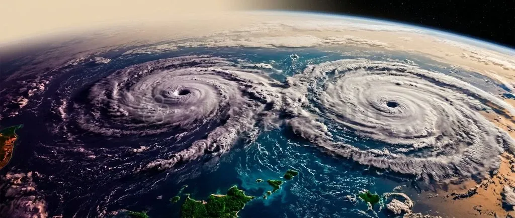
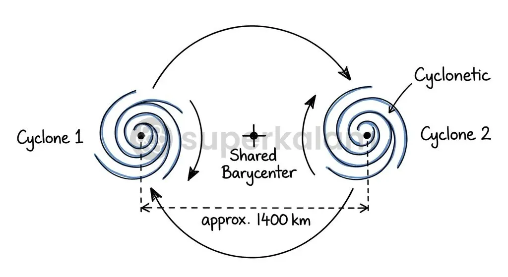
The Fujiwhara effect occurs when two tropical cyclones approach within approximately 1,400 kilometres of each other. They initiate a mutual orbital dance around a shared centre of mass known as a barycentre. This binary interaction causes erratic track deviations, rapid intensity fluctuations, and potential vortex mergers that disrupt standard single-vortex numerical weather prediction models.
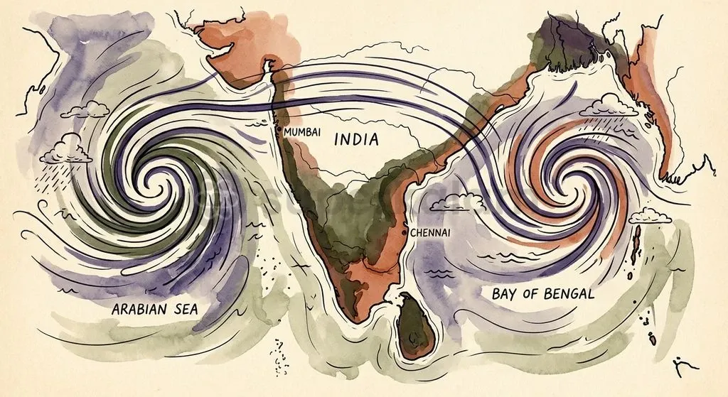
In the North Indian Ocean basin, simultaneous storm systems across the Arabian Sea and the Bay of Bengal can exert non-linear teleconnections. Upper-tropospheric outflow from one vortex distorts the ambient steering flow of the other. As rising sea surface temperatures expand the window for concurrent cyclogenesis, operational agencies like the India Meteorological Department face compounding forecasting challenges that directly cut into coastal evacuation lead times.
Why the Fujiwhara Effect Is in the News
The India Meteorological Department closely monitors binary cyclonic systems due to forecasting anomalies during simultaneous cyclogenesis across the North Indian Ocean basin. In October 2023, the basin generated concurrent twin disturbances: Extremely Severe Cyclonic Storm Tej over the Arabian Sea and Very Severe Cyclonic Storm Hamoon over the Bay of Bengal.
According to reports from the India Meteorological Department, upper-tropospheric outflow from Cyclone Tej altered the steering and wind shear environment around Cyclone Hamoon. This dynamical interaction created two operational challenges:
- Abrupt Track Recurvature: Cyclone Hamoon veered sharply northeastwards toward Bangladesh instead of following the climatologically expected west-northwest vector toward the Indian coast.
- Rapid Category Shifts: Cyclone Hamoon changed intensity categories four times within 24 hours prior to landfall, rapidly escalating to a Very Severe Cyclonic Storm before weakening prior to crossing the coast.
These sudden operational shifts highlight how binary atmospheric interactions strain traditional early warning timelines.
Discuss with Superkalam
Can you recall the separation distance threshold established by the World Meteorological Organization at which binary cyclone interaction begins?
Ask NowWhat Is the Fujiwhara Effect and How Does It Work?
The Fujiwhara effect describes the physical process where two sufficiently close cyclonic vortices orbit around a common barycentre through mutual advective steering. Japanese meteorologist Sakuhei Fujiwhara first documented this phenomenon in 1921 through water tank experiments showing that co-rotating fluid vortices naturally attract and rotate about a shared centroid.
Under guidelines established by the World Meteorological Organization, binary tropical cyclone interaction initiates when storm centres fall within approximately 1,400 kilometres, or roughly 10 to 14 degrees of latitude. When crossing this threshold, outer circulating wind fields begin steering each vortex, producing a cyclonic mutual rotation.
Planetary rotation dictates the orbital direction through the Coriolis force. Interacting systems rotate counter-clockwise around their shared barycenter in the Northern Hemisphere and clockwise in the Southern Hemisphere. The interaction strength depends on the relative size, core intensity, and initial separation distance of the two tropical cyclones.
| Parameter | Single Cyclone Dynamics | Fujiwhara Binary Dynamics |
|---|---|---|
| Primary Steering Mechanism | Large-scale environmental subtropical ridges | Combined environmental flow and mutual vorticity advection |
| Orbital Centre | Independent system core | Shared common barycenter |
| Separation Threshold | Not applicable (>1,400 km) | Within 1,400 km (10–14° latitude) |
| Track Predictability | High to moderate (deterministic) | Highly non-linear with erratic recurvatures |
| Structural Fate | Landfall dissipation or extratropical transition | Straining-out, ejection, separation, or complete merger |
The Five Stages: How Twin Storms Orbit, Repel, or Merge
Binary cyclonic interactions resolve into five structurally distinct operational outcomes depending on storm size, intensity disparity, and core separation distance. Atmospheric scientists L. E. Carr and R. L. Elsberry classified these interactions to objectively diagnose structural evolutions between two tropical systems:
- Elastic Interaction: The two cyclones approach the interaction threshold and execute mutual cyclonic rotation around their barycenter. Both systems alter their tracks via mutual cyclonic steering but retain their core structures and eventually separate without merging.
- Partial Straining-Out: When one cyclone possesses significantly greater intensity or size, horizontal wind shear from the dominant storm strips away outer convective rainbands from the smaller partner. The weaker system suffers structural degradation but maintains an identifiable vortex core.
- Complete Straining-Out (One-Sided Ejection): The shearing forces exerted by the dominant system completely tear apart the weaker companion. The smaller cyclone is dismantled into an elongated vorticity filament or sheared band, functionally destroying its organized core.
- Partial Merger: The two cyclonic circulations approach close enough for convective mixing, where outer cores blend while secondary vorticity maxima temporarily persist before being absorbed.
- Complete Merger: Two tropical cyclones approach within a critical separation distance, typically under 750 to 800 kilometres. Their central cores coalesce directly into a single, broader cyclonic circulation.
Discuss with Superkalam
How does the Coriolis force determine the orbital direction of two interacting cyclones in the Northern versus Southern Hemispheres?
Ask NowHas the Fujiwhara Effect Occurred in the Indian Ocean?
The North Indian Ocean basin rarely witnesses direct core-merger events because the Indian subcontinent physically bifurcates the basin into the Arabian Sea and the Bay of Bengal. However, simultaneous cyclogenesis and dynamical teleconnections occur regularly across these separate sub-basins.
Two regional historical events illustrate how these dynamics unfold in practice:
- Inter-Basin Teleconnections (North Indian Ocean): The India Meteorological Department recorded simultaneous twin cyclogenesis in October 2018 when Very Severe Cyclonic Storm Titli formed in the Bay of Bengal while Very Severe Cyclonic Storm Luban developed concurrently over the Arabian Sea. While the landmass prevented physical core coalescence, large-scale moisture convergence and upper-tropospheric outflow created subtle inter-basin atmospheric linkages.
- Direct Open-Ocean Merger (South Indian Ocean): In April 2021, Severe Tropical Cyclone Seroja engaged in a pronounced Fujiwhara interaction with Tropical Cyclone Odette off Western Australia. The two storms executed a rapid mutual cyclonic orbit that culminated in Cyclone Seroja absorbing Cyclone Odette before making landfall.
Why Binary Cyclones Pose a Major Headache for IMD Forecasters
Predictive skill drops noticeably during binary events because standard numerical weather prediction frameworks struggle with multi-vortex non-linear dynamics. Research published by the American Meteorological Society demonstrates that conventional single-vortex tracking models fail to account for non-linear horizontal advection and diabatic heating asymmetries induced by a companion storm.
The India Meteorological Department maintains strict verification metrics for cyclone tracking. For the five-year period from 2019 to 2023, average operational track forecast errors across the North Indian Ocean stood at 72 kilometres at 24 hours, 112 kilometres at 48 hours, and 156 kilometres at 72 hours.
During 2023, the operational Multi-Model Ensemble track forecast errors across all North Indian Ocean storms registered at 59 kilometres at 24 hours, 101 kilometres at 48 hours, 168 kilometres at 72 hours, 178 kilometres at 96 hours, and 199 kilometres at 120 hours.
Operational verification findings from the IMD confirmed that disturbances undergoing sharp track recurvature and rapid intensity shifts—such as Cyclone Tej—produced significantly elevated forecast errors compared to straight-moving baseline storms. These deviations impair coastal preparedness in three primary ways:
- Distorted Steering Currents: Outflow from one cyclone introduces unexpected vertical wind shear over the other, displacing the convective core.
- Rapid Intensity Volatility: The companion vortex can suppress inflow channels or abruptly inject moisture, causing unpredicted intensification or rapid decay.
- Landfall Dislocation: Sudden orbital loops create misplaced coastal evacuations, deploying emergency resources to administrative districts that avoid the ultimate storm strike.
Discuss with Superkalam
If two cyclones form simultaneously in the Arabian Sea separated by 600 kilometres, which structural stage classified by Carr and Elsberry would they most likely exhibit?
Ask NowClimate Change and Warming Seas: Are Double Cyclones Becoming More Common?
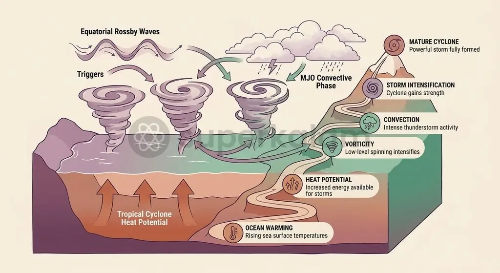
Rising ocean temperatures alter the thermodynamic baseline of the North Indian Ocean, creating conditions conducive to simultaneous cyclogenesis. According to assessment reports by the Ministry of Earth Sciences, sea surface temperatures across the Arabian Sea and equatorial Indian Ocean have warmed at rates exceeding 0.12°C to 0.15°C per decade.
Two interdependent factors drive this increasing frequency of dual systems:
- Elevated Ocean Heat Content: Sustained warming elevates the Tropical Cyclone Heat Potential, which measures thermal energy stored in the upper ocean down to the 26°C isotherm. Higher heat potential ensures that even when a leading cyclonic system upwells cooler sub-surface water, surrounding waters remain warm enough to sustain a second concurrent vortex.
- Coaligned Dynamic Triggers: Technical studies by the National Centre for Medium Range Weather Forecasting show that Equatorial Rossby waves and the active convective phase of the Madden-Julian Oscillation deliver the planetary vorticity and moisture convergence necessary for twin storms to develop simultaneously across the Arabian Sea and Bay of Bengal.
Improving Early Warning: How India Can Better Track Complex Storms
Managing binary cyclonic threats requires upgrading deterministic forecasting into dynamic ensemble frameworks backed by high-resolution observation networks. To capture track divergence in multi-vortex scenarios, the National Centre for Medium Range Weather Forecasting operates the NCMRWF Unified Model global ensemble prediction system (NEPS-G) at 12-kilometre horizontal resolution and a dedicated regional system (NEPS-R) at 4-kilometre resolution.
High-resolution regional grids resolve localized wind shears that govern whether twin vortices merge or repel. Complementing these ensemble predictions, the India Meteorological Department operationally executes the Hurricane Weather Research and Forecasting model. This system utilises movable vortex-following nests updated four times daily to project intensity and tracking pathways across 120-hour lead periods.
Observational platforms supply the baseline data required to initialise these numerical equations:
- Ocean Moored Buoy Networks: In-situ data assimilation from the Ocean Moored Buoy Network (OMNI) deployed by the National Institute of Ocean Technology and RAMA moored buoys managed by the Indian National Centre for Ocean Information Services captures real-time upper-ocean thermal profiles.
- Space-Based Scatterometry: Satellite scatterometer wind retrievals from Oceansat-3 (SCAT-3 Ku-band) allow forecasters to accurately identify distinct surface circulation centres and map asymmetric wind radii during complex binary events.
Combining high-resolution numerical models with real-time ocean and satellite observations provides disaster managers with the predictive reliability needed to coordinate safe evacuations along vulnerable coastlines.
Discuss with Superkalam
Compare how single-cyclone steering mechanisms differ from binary cyclonic dynamics when interacting systems approach a shared barycentre.
Ask NowKey Takeaways
- Japanese meteorologist Sakuhei Fujiwhara first identified the Fujiwhara effect in 1921, demonstrating how co-rotating fluid vortices orbit around a shared centroid.
- Binary tropical cyclone interaction typically initiates when two storms approach within approximately 1,400 kilometres (10 to 14 degrees of latitude) of each other.
- The Coriolis force causes interacting cyclones to rotate counter-clockwise in the Northern Hemisphere and clockwise in the Southern Hemisphere around their common barycenter.
- Binary interactions produce five structural outcomes: elastic interaction, partial straining-out, complete straining-out, partial merger, and complete merger (which occurs under 750 to 800 kilometres separation).
- Simultaneous storms like Cyclone Tej and Cyclone Hamoon in October 2023 illustrate how inter-basin teleconnections induce erratic track recurvatures and rapid intensity category changes.
- Operational forecasting relies on the NCMRWF Unified Model ensemble prediction systems (NEPS-G at 12 km and NEPS-R at 4 km) along with Oceansat-3 scatterometer data to resolve multi-vortex tracks.
Mains Question
"Binary cyclonic interactions disrupt deterministic numerical weather prediction frameworks, transforming cyclone tracking from a single-vortex steering problem into a complex non-linear challenge." In the light of the India Meteorological Department's experience during the concurrent occurrence of Cyclone Tej and Cyclone Hamoon, elucidate. (10 Marks)
Evaluate NowMains Question
According to the Ministry of Earth Sciences, warming across the Arabian Sea and equatorial Indian Ocean has exceeded 0.12°C to 0.15°C per decade, expanding the window for concurrent cyclogenesis. Critically examine the disaster management implications of binary cyclones for coastal evacuation and administrative preparedness. (15 Marks)
Evaluate NowPractice MCQs
QUESTION 1
With reference to the Fujiwhara effect, consider the following statements:
- According to World Meteorological Organization guidelines, binary interaction initiates when tropical cyclone centres fall within approximately 1,400 kilometres of each other.
- In the Northern Hemisphere, interacting cyclonic systems orbit clockwise around their common barycentre due to the Coriolis force.
- Complete merger of two tropical cyclones typically occurs when their separation distance falls below 750 to 800 kilometres.
Which of the statements given above are correct?
QUESTION 2
Consider the following statements regarding tropical cyclone interactions classified by Carr and Elsberry:
- In an elastic interaction, both cyclones alter their tracks through mutual steering while retaining their core structures and eventually separating.
- Complete straining-out occurs when shearing forces dismantle the weaker cyclone into an elongated vorticity filament.
- Partial merger involves outer rainband stripping where the weaker system maintains its identifiable core without any mixing of circulations.
Which of the statements given above is/are correct?
QUESTION 3
Consider the following pairs of tropical cyclone events and their observed atmospheric dynamics:
- Cyclone Tej and Cyclone Hamoon (2023) : Inter-basin teleconnection where outflow altered ambient steering and caused sharp track recurvature.
- Cyclone Titli and Cyclone Luban (2018) : Complete core merger over the central Indian subcontinent.
- Cyclone Seroja and Cyclone Odette (2021) : Mutual cyclonic orbit culminating in an open-ocean merger in the South Indian Ocean.
How many of the above pairs are correctly matched?
QUESTION 4
Which of the following factors primarily accounts for the operational track forecast errors and rapid intensity shifts observed by the India Meteorological Department during binary cyclone events?
QUESTION 5
With reference to cyclogenesis trends in the North Indian Ocean noted in reports by the Ministry of Earth Sciences, consider the following statements:
- Sea surface temperatures across the Arabian Sea and equatorial Indian Ocean have warmed at rates exceeding 0.12°C to 0.15°C per decade.
- The Indian subcontinent prevents direct physical core mergers between storms originating concurrently in the Arabian Sea and the Bay of Bengal.
Which of the statements given above is/are correct?
Discuss with Superkalam
Evaluate the administrative trade-offs coastal disaster managers face when cyclone forecast tracks exhibit high uncertainty due to binary interactions.
Ask Now