Cyclones in India: Formation, Classification & Impact — UPSC Geography
Oct, 2025
•4 min read
Cyclones are a key topic for the UPSC Civil Services Examination, covered under GS Paper 1 (Physical Geography) and GS Paper 3 (Disaster Management and Current Affairs). Questions often test your understanding of their formation (genesis), types, impacts on climate and human life, and mitigation measures.
Here, we’ll cover everything you need to know about Cyclones for UPSC, from their meaning and classification to their effects and disaster management strategies, strictly aligned with the UPSC syllabus.
What is a Cyclone?
A cyclone is a big storm with strong winds that move around a center of low pressure. It forms over warm ocean water and can bring heavy rain and strong winds. The word "cyclone" comes from the Greek word "Cyclos," meaning the coils of a snake, and was coined by Henry Piddington because these storms appear like coiled serpents of the sea.
- Cyclones rotate counterclockwise in the Northern Hemisphere and clockwise in the Southern Hemisphere.
- They draw their energy from warm ocean waters, typically above 26 °C to 27 °C.
- The center of a cyclone, known as the "eye," is typically calm with clear skies.
- They are known by different names in different regions - hurricanes in the Atlantic, typhoons in the Pacific, and cyclones in the Indian Ocean.
Classification of Cyclones
Cyclones are classified into different types based on their location, formation process, and characteristics.
1. Tropical Cyclones
Tropical cyclones are the most destructive and well-known type of cyclones that form over warm tropical oceans between 5° and 30° latitude.
- Formation Zone: Between the Tropic of Cancer and the Tropic of Capricorn (5°-30° latitude).
- Temperature Requirement: Sea surface temperature above 26.5-27°C for at least 60m depth.
- Different Names: Called hurricanes (Atlantic), typhoons (Pacific), and cyclones (Indian Ocean).
- Peak Season: Late summer to early winter (August to mid-November).
- Direction: Counterclockwise in the Northern Hemisphere, clockwise in the Southern Hemisphere.
- Speed: Can travel 480-640 km per day, lasting about 4828 km before dissipating.
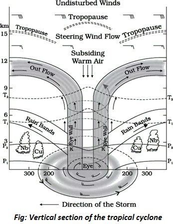
- Structure: Well-defined eye (calm center), eyewall (strongest winds), and spiral rainbands.
Essential Conditions for Formation of Tropical Cyclones:
- Warm ocean water (above 27°C) is a significant energy source.
- Presence of Coriolis force (minimum 5° from the equator).
- Low vertical wind shear to allow vertical cloud development.
- Pre-existing low-pressure disturbance.
- High humidity in the mid-troposphere (50-60%).
- Upper-level divergence for air to escape upward.
Stages of Development of a Tropical Cyclone:
There are three important stages of development of a tropical cyclone:
- Formation Stage: Transfer of water vapor and heat from the ocean to the atmosphere.
- Mature Stage: Development of the eye, eyewall, and organized spiral bands.
- Decay Stage: Weakening when moving over land or cold water.
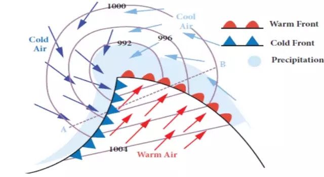
2. Extratropical Cyclones (Temperate Cyclones)
Also known as mid-latitude cyclones, temperate cyclones, or frontal cyclones, these form in middle latitudes between 30° and 65° latitude.
- Formation Zone: Between 30°-65° latitude in both hemispheres.
- Theory: Explained by Polar Front Theory by Bjerknes (1918).
- Movement: West to east direction, more pronounced in winter.
- Duration: Individual cyclones last 3-10 days.
- Size: Covers larger areas than tropical cyclones.
- Fronts: Associated with warm fronts, cold fronts, and occluded fronts.
Key Characteristics of Extratropical Cyclones:
- Lower wind speeds than tropical cyclones, but with steep temperature gradients.
- It can form over land and sea.
- Responsible for much of the severe winter weather.
- Example: Nor'easter storms affecting the US East Coast.
Formation Process (Polar Front Theory):
- Stage I (Frontogenesis): Warm and cold air masses meet along the polar front.
- Stage II (Cyclogenesis): Air masses push into each other, creating wave formation.
- Stage III (Mature Stage): Well-developed cyclone with distinct fronts.
- Stage IV (Occlusion): Cold front overtakes warm front, cyclone dissipates.
3. Polar Cyclones
Small but intense cyclones that form in polar regions, also called "Arctic hurricanes" or "polar lows".
- Formation Zone: Above 60° latitude in polar regions (Arctic and Antarctic).
- Size: Much smaller than other cyclone types.
- Development Time: Forms rapidly, often in less than 24 hours.
- Energy Source: Heat transfer from water to air and latent heat release.
- Seasonality: Strongest during winter months.
- Movement: Contained within the jet stream in the Northern Hemisphere.
Impact of Polar Cyclones on Weather:
- Bring extreme cold temperatures to lower latitudes.
- It can cause "polar vortex" events affecting temperate regions.
- Create unseasonably cold conditions far from the poles.
- It can kill crops and cause energy crises.
4. Mesocyclones
Mesocyclones are small-scale rotating thunderstorms that can develop into tornadoes. These cyclones represent a transitional stage between thunderstorms and tornadoes.
- Scale: Much smaller than other cyclone types (storm-scale).
- Formation: Develops within severe thunderstorms.
- Rotation: Rotating air within a thunderstorm due to the Coriolis force.
- Tornado Connection: Can produce tornadoes when the cloud extends to the ground.
- Duration: Short-lived compared to larger cyclones.
Key Characteristics of Mesocyclones:
- The most serious type of thunderstorm.
- Produces large hailstorms and strong gusty winds.
- It can cause significant destruction despite its small size.
- Contains rotating air along the vertical axis.
Must read: Bharat Forecast System: Launch, Objectives & Key Details
Process of Formation of Cyclones
The formation of cyclones is a complex process that requires specific atmospheric and oceanic conditions. Understanding this process helps in predicting and preparing for these natural disasters.
1. Initial Heating and Low-Pressure Formation
- Warm ocean water (above 26-27°C) heats the air above it.
- The heated air becomes lighter and rises, creating a low-pressure area at the surface.
- Surrounding air rushes in to fill this void.
2. Air Circulation and Spin
- The Coriolis force, caused by Earth's rotation, makes the incoming air spin.
- This creates a rotating system of winds around the low-pressure centre.
- The system spins counterclockwise in the Northern Hemisphere and clockwise in the Southern Hemisphere.
3. Moisture and Cloud Formation
- Rising warm air carries water vapour from the ocean surface.
- As this air rises higher, it cools and water vapour condenses into clouds.
- The condensation process releases latent heat, providing more energy to the system.
4. Intensification and Eye Formation
- The continuous cycle of heating, rising air, and condensation strengthens the system.
- As the system rotates faster, a calm central area called the "eye" forms.
- Strong winds develop around the eye, creating the eyewall.
- The storm system can now be classified as a cyclone.
Also read: Mount Lewotobi Laki Laki: Indonesia's Active Volcano
Factors Affecting the Formation of Cyclones
Different environmental conditions affect whether a cyclone will form, grow stronger, or weaken. Its development depends on how various weather and ocean factors work together. Here are the key factors that affect the formation of cyclones:
- Sea surface temperature affects energy availability: warm waters above 26.5°C promote formation while cool waters inhibit development.
- Vertical wind shear controls storm organization: low shear allows development, while strong shear disrupts cyclone structure.
- Atmospheric moisture determines fuel supply: high humidity sustains cyclones while dry air intrusion weakens them.
- Upper-Level pressure systems influence ventilation: high pressure aloft enhances divergence while low pressure suppresses development.
- Climate patterns modulate seasonal activity: El Niño/La Niña cycles affect cyclone frequency and regional distribution.
- Ocean heat content impacts intensification potential: deeper warm layers support rapid strengthening.
- Environmental temperature gradients control atmospheric stability: strong gradients promote formation, while weak gradients inhibit development.
Also read: Mahanadi River Inter-State Water Dispute
Cyclones in India
India has a long coastline of about 7,516 km, bordered by the Arabian Sea, Bay of Bengal, and the Indian Ocean. Because of this location, it is one of the most cyclone-prone countries in the world. Every year, India experiences two to three tropical cyclones on average.
1. Geographic Vulnerability
- India has 9 coastal states and 4 Union Territories affected by cyclones.
- 7,516 km coastline, with 5,400 km along the mainland, makes India highly exposed.
- Four states (Andhra Pradesh, Odisha, Tamil Nadu, and West Bengal) and one UT (Puducherry) are most vulnerable.
2. Cyclone Frequency and Distribution
- 2-3 tropical cyclones make landfall in India each year on average.
- The Bay of Bengal produces 4 times more cyclones than the Arabian Sea (ratio 4:1).
- The North Indian Ocean generates only 7% of the world's cyclones, but causes disproportionate damage.
3. Most Vulnerable Regions
- East Coast (High Risk): Odisha (most affected), West Bengal, Andhra Pradesh, Tamil Nadu.
- West Coast (Moderate Risk): Gujarat, Maharashtra (Arabian Sea cyclones).
- Island Territories: Andaman & Nicobar Islands, Lakshadweep.
4. Bay of Bengal Dominance
- Higher sea surface temperatures (28-32°C) throughout the year.
- Funnel-like shape concentrates and amplifies storm surges.
- Warm river discharge from the Ganga, Brahmaputra maintains surface temperatures.
- Shallow coastal waters allow higher storm surge penetration inland.
5. Recent Major Cyclones in India
- Cyclone Fani (May 2019): Odisha
- Cyclone Amphan (May 2020): West Bengal and Odisha.
- Cyclone Nisarga (June 2020): Made landfall near Alibag, Maharashtra.
- Cyclone Yaas (May 2021): Landed in Odisha and West Bengal.
- Cyclone Tauktae (May 2021): Gujarat coast
- Cyclone Sitrang (Oct 2022): Struck West Bengal and Bangladesh.
- Cyclone Mocha (May 2023): One of the strongest Bay of Bengal storms with 215 kmph winds, affected Myanmar and Bangladesh.
- Cyclone Biparjoy (June 2023): along the Gujarat and Rajasthan coasts.
- Cyclone Remal (Oct 2024): Hit Andhra Pradesh and Odisha
- Cyclone Tej (Nov 2024): near Kalingapatnam, Andhra Pradesh
- Cyclone Hamoon (June 2025): Approached West Bengal and Odisha.
- Cyclone Shakti (October 2025): Along Maharashtra and Gujarat.
Early Warning System in India for Cyclones
- India Meteorological Department (IMD) monitors cyclones using satellite imagery, ocean buoys, and cyclone detection radars.
- Cyclone Warning Centers (CWCs) and Area Cyclone Warning Centers (ACWCs) issue warnings based on cyclone tracking.
- IMD follows a four-stage warning system: Pre-Cyclone Watch (72 hrs), Cyclone Alert (48 hrs), Cyclone Warning (24 hrs), and Landfall Outlook (12 hrs).
- The Bharat Forecast system helps in rapid and reliable communication of cyclone warnings to administration, fishermen, and coastal communities.
Multiple Choice Questions
QUESTION 1
Medium
Indian Geography
With reference to a tropical cyclone, consider the following statements:
1.Cyclones are intensified by the energy released during condensation in cumulonimbus clouds.
2.Minimum wind speed is attained in the eye-wall region.
3.The eye of a tropical cyclone has abnormally high temperature and lowest pressure.
Which of the statements given above is/are correct?
Select an option to attempt
Difference Between Cyclones and Anticyclones
Cyclones and anticyclones are basic weather systems that affect the weather all around the world. Knowing the difference between them helps us understand how the weather changes and affects our daily lives.
| Cyclone | Anticyclone |
|---|---|
| Low pressure at the centre, high pressure surrounding. | High pressure at the centre, low pressure surrounding. |
| Air rises upward (convergence) | Air sinks downward (divergence) |
| Counterclockwise (anticlockwise) in the Northern Hemisphere | Clockwise in the Northern Hemisphere |
| Clockwise in the Southern Hemisphere. | Counterclockwise (anticlockwise)in the Southern Hemisphere. |
| High (50-250 km/hour) | Low (30-50 km/hour) |
| Stormy, cloudy, heavy rainfall, thunderstorms | Clear skies, calm, dry weather |
| Rising air cools and condenses, forming clouds | Descending air warms and dries, suppressing clouds |
| Heavy rainfall, storms | Little to no precipitation |
| Rapid temperature changes | Gradual temperature changes |
| Smaller diameter (200-2000 km) | Larger diameter (3000-8000 km) |
| Short-lived, moves fast | Long-lasting, moves slowly |
| Tropical and temperate regions | Subtropical and polar regions |
| Summer: Intense storms, heavy rain Winter: Snow, sleet, mixed precipitation | Summer: Hot, dry, clear skies, possible heat waves Winter: Cold, frost, fog formation |
Key Disaster Preparedness Strategies for Cyclones
Effective disaster resilience combines planning, infrastructure, community engagement, and ecosystem protection to reduce cyclone impacts and save lives.
- Develop and enforce cyclone-resilient building codes for homes, schools, and hospitals.
- Establish local early warning systems with clear evacuation protocols and communication in regional languages.
- Train and equip community volunteers as first responders for search, rescue, and relief operations.
- Integrate nature-based solutions like mangrove restoration and dune reinforcement to buffer storm surges.
- Create multi-hazard shelters and stock essential supplies (food, water, medicine) in cyclone-prone areas.
UPSC Mains Practice Question
Why is the Bay of Bengal more prone to cyclones compared to the Arabian Sea? Discuss this phenomenon with reference to recent cyclones in India. (250 words)
Evaluate Your Answer Now!Way Forward
A clear plan combining better forecasts, stronger buildings, community training, nature’s barriers, and teamwork will help India face cyclones more safely.
- Use advanced weather tech for earlier and more reliable warnings.
- Build and retrofit homes and schools to withstand strong winds and floods.
- Teach local communities safety steps, run practice drills, and share warnings in local languages.
- Protect and restore mangroves, dunes, and reefs to block storm surges.
- Work with neighboring countries to share data and join relief efforts.
SuperKalam – Your 24x7 AI Mentor for UPSC!
- Instant Doubt Resolution
- Instant Mains Answer Evaluation for GS, Ethics & Essay
- Unlimited MCQ & PYQ Practice
Start today and experience smart learning!