Western Ghats Protection Fails: The Politics of State Vetoes and ESAs - UPSC Notes
Unpacking the federal tensions and administrative gridlocks stalling the 56,825.7 sq km Western Ghats Ecologically Sensitive Area notifications.
Sep, 2026
•12 min read
Overview

Fig: The Western Ghats host over 30 percent of India's biodiversity while acting as the primary water tower for Peninsular India.
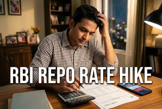
The Ministry of Environment, Forest and Climate Change reissued its seventh draft notification in July 2026 to designate 56,825.7 square kilometers of the Western Ghats as an Ecologically Sensitive Area. This decision attempts to resolve a fifteen-year governance impasse caused by competing state economic interests and administrative deadlocks.
This legislative inertia stems from a structural conflict between central mandates under the Environment (Protection) Act, 1986, and state-level political priorities. Ecological reports emphasise protecting Peninsular India's primary water tower against climate disasters. Meanwhile, affected state governments exercise informal vetoes through procedural lapses. Sustainable conservation requires moving toward institutionalised cooperative federalism, flexible livelihood-centric zoning, and direct fiscal transfers for ecological services.
Why in the News?
As of July 2026, the Ministry of Environment, Forest and Climate Change has reissued the seventh draft notification declaring 56,825.7 square kilometers of the Western Ghats an Ecologically Sensitive Area. The previous sixth draft notification, issued in July 2024, lapsed without finalisation under Rule 5(3)(d) of the Environment (Protection) Rules, 1986. This statutory provision mandates that draft environmental restrictions lapse if not finalised within 545 days.
Key factors driving this administrative re-issuance include:
- Judicial pressure: The National Green Tribunal directed the Ministry in July 2025 to expedite the final notification.
- Disaster urgency: Catastrophic landslides in July 2024 at Chooralmala and Mundakkai in Kerala's Wayanad district claimed over 290 lives in ecologically fragile terrain.
Tracing the Timeline: From Gadgil to Kasturirangan and Beyond
The policy framework for conserving this vulnerable mountain chain evolved through three main committees:
- Gadgil Panel (August 2011): Chaired by ecologist Madhav Gadgil, the Western Ghats Ecology Expert Panel recommended designating 1,29,037 square kilometres—approximately 64% of the region—as an Ecologically Sensitive Area. It proposed a three-tiered zoning system overseen by a statutory Western Ghats Ecology Authority under the Environment (Protection) Act, 1986, with decision-making vested in local Gram Sabhas.
- Kasturirangan Panel (April 2013): Facing state opposition, the Ministry constituted a High Level Working Group under Dr. K. Kasturirangan. This panel narrowed the proposal to ~37% of the landscape (~59,940 square kilometres). Utilising 24-metre resolution remote sensing spatial data from the ISRO-National Remote Sensing Centre, it categorised the land into 'Natural Landscapes' requiring protection and 'Cultural Landscapes' containing human settlements.
Sanjay Kumar Committee (April 2022): To reconcile state objections and verify ground boundaries on village cadastral maps, the Ministry set up an Expert Committee headed by former Director General of Forests Sanjay Kumar. In June 2026, the Ministry extended its tenure to July 2027 to complete ground-truthing across six riparian states.
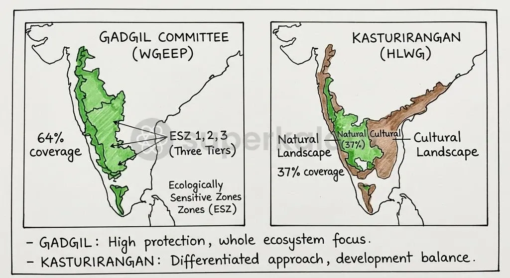
Fig: The evolution of Eco-Sensitive Area demarcation moved from a broad 64 percent zoning approach under Gadgil to a refined 37 percent natural landscape model under Kasturirangan.
Discuss with Superkalam
Which statutory rule under the Environment (Protection) Rules, 1986 specifies that draft notifications lapse if not finalised within 545 days?
Ask NowUnderstanding the Western Ghats Eco-Sensitive Area Push
Section 3(2)(v) of the Environment (Protection) Act, 1986 empowers the Central Government to restrict industrial operations in ecologically fragile zones. An Ecologically Sensitive Area (ESA) is a buffer zone around protected natural spaces to absorb environmental shocks and prevent habitat fragmentation.
Under the seventh draft notification, proposed prohibitions strictly target high-impact commercial operations while seeking to shield rural community livelihoods.
- Completely Banned Activities: New commercial mining and quarrying, sand mining, new thermal power plants, highly polluting 'Red Category' industries, and large construction projects with a built-up area of 20,000 square metres or above.
- Permitted and Exempted Operations: Ongoing agricultural practices, plantation activities, and day-to-day local community livelihood operations are explicitly exempted from prohibition.
The table below highlights the key structural differences between the two seminal expert committee frameworks that shape the current draft notifications:
| Parameter | Gadgil Committee (WGEEP, 2011) | Kasturirangan Panel (HLWG, 2013) |
Total ESA Coverage | 1,29,037 sq km (~64% of Western Ghats) | ~59,940 sq km (~37% of Western Ghats) |
Demarcation Methodology | Gridded eco-sensitivity criteria based on slope, forest cover, and hydrology | Remote sensing (24m ISRO-NRSC) separating Natural vs Cultural landscapes |
Governance Architecture | Statutory Western Ghats Ecology Authority under EPA 1986 | Existing regulatory framework under MoEFCC and State Pollution Control Boards |
Local Authority Role | Bottom-up decision-making vested directly in Gram Sabhas | Village used as basic administrative unit; top-down regulatory enforcement |
Red Category Industries | Complete ban across Ecologically Sensitive Zone 1 | Complete prohibition across designated Natural Landscapes |
The Core Clash: Centre's Conservation Mandate versus State Development Priorities
The Seventh Schedule's distribution of legislative powers creates tension between central environmental directives and state developmental authority. Following the 42nd Constitutional Amendment Act of 1976, 'Forests' and 'Protection of Wild Animals and Birds' moved from the State List to the Concurrent List under Entries 17A and 17B. This shift empowers Parliament to enact overarching legislation like the Environment (Protection) Act, 1986.
However, critical development sectors remain under exclusive State List jurisdiction:
- Land (Entry 18)
- State Public Works (Entry 35)
- Industries (Entry 24)
When central notifications issue blanket bans under Section 3(2)(v), states view them as an encroachment on their autonomy to plan infrastructure and local resource use.
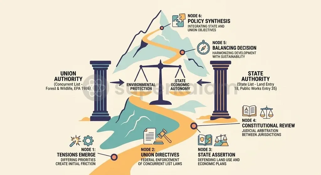
Fig: Constitutional friction arises when Union environmental directives under the Concurrent List intersect with exclusive State jurisdiction over land and local infrastructure.
This constitutional divide is amplified by the asymmetric spatial distribution of the proposed Ecologically Sensitive Area across the six affected states:
- Karnataka: Contains the largest proposed coverage at 20,668 sq km.
- Maharashtra: Encompasses 17,340 sq km under the central draft.
- Kerala: Accounted for 9,993.7 sq km in the proposed boundary.
- Tamil Nadu: Covers 6,914 sq km of designated hilly tracts.
- Goa: Includes 1,461 sq km of ecologically fragile forest area.
- Gujarat: Contains 449 sq km at the northern boundary.
The Union government has historically relied on executive draft notifications rather than constitutional consensus-building mechanisms like the Inter-State Council under Article 263. Consequently, states frequently use administrative friction to stall implementation.
DIscuss with Superkalam
How does the Kasturirangan Panel's landscape classification differ from the Gadgil Panel's eco-sensitivity approach?
Ask NowUnpacking the Political Economy of State-Level Vetoes
Rule 5(3)(d) of the Environment (Protection) Rules, 1986 grants state governments an implicit veto by allowing draft notifications to lapse after 545 days. By withholding formal concurrence or submitting continuous requests for boundary revisions, states stall the statutory process, forcing repeated fresh drafts.
To break this multi-state deadlock, the 2024 and 2026 draft notifications introduced a phased implementation clause. This regulatory modification allows the Central Government to issue final ESA notifications on a state-by-state basis rather than waiting for simultaneous consensus across all six states.
State responses to the proposed boundaries reflect distinct local political dynamics:
- Gujarat and Goa: Both states have largely agreed to the ESA boundaries demarcated within their administrative territories.
- Maharashtra: The state submitted a revised village proposal that remains under formal appraisal by the Sanjay Kumar Expert Committee as of July 2026.
- Karnataka: On 22 September 2026, the Legislative Assembly unanimously adopted a resolution seeking review and modification of the Kasturirangan report, saying the current ESA proposal could not be accepted as it stood. The state said it would seek a year for a physical survey to distinguish forests from farms and inhabited areas; this is a requested survey period, not an approved extension or final boundary change. Earlier state opposition had already stalled demarcation.
- Kerala: The state submitted a proposal to limit its ESA coverage to 8,711.98 sq km, requesting the explicit exclusion of populated settlements and agricultural areas across 98 villages.
What Local Communities and State Governments Fear
Livelihood anxiety and infrastructure fears drive state-level resistance to the proposed restrictions:
- Karnataka's Malnad region: Concerns span more than 1,500 villages where local economies rely on coffee and rubber plantations, stone quarrying, and road expansions. Residents fear strict ESA rules will freeze infrastructure development and hamper local growth.
- Kerala's high-density districts: High population density creates intense public anxiety over land-use restrictions. The state's request to exclude human habitations across 98 villages in Wayanad, Idukki, and Malappuram reflects fears that building bans could halt essential community infrastructure like housing, roads, and small commercial establishments.
Although central notifications explicitly exempt day-to-day agricultural operations, local political leaders argue that blanket building restrictions severely limit economic mobility.
The Ecological Cost of Delayed Protection
The Western Ghats mountain range hosts over 30 percent of India's flora and fauna across a 1,500-kilometre stretch from Gujarat to Tamil Nadu. Occupying less than 6 percent of India's land area, this mountain system is a biological reservoir of global importance.
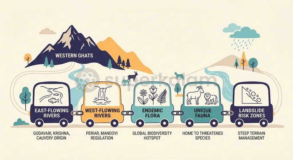
Fig: The ecological cost of delayed protection manifests in heightened landslide risks and habitat fragmentation across Peninsular India's key river basins.
This fragile landscape fulfils two vital regional roles:
- Biological reservoir: Houses thousands of endemic species requiring contiguous, unfragmented habitats.
- Peninsular water tower: Acts as the catchment origin for major east-flowing river systems (Godavari, Krishna, Cauvery) and vital west-flowing rivers (Periyar, Mandovi, Sharavathi).
Unregulated land-use changes, quarrying, and steep-slope construction severely degrade this hydrological recharge function, directly escalating regional climate vulnerability.
Discuss with Superkalam
Does the phased implementation clause strengthen cooperative federalism or weaken ecological protection?
Ask NowWhat Needs to Change to Break the Policy Impasse
Reforming Western Ghats governance requires a three-pronged institutional approach:
- Flexible infrastructure clearances: Policy research groups like ATREE and the Vidhi Centre for Legal Policy recommend exempting basic rural infrastructure—such as rural roads, schools, and Primary Health Centres—from rigid environmental clearance hurdles. Meanwhile, strict Category-A Environmental Clearance requirements should remain for major highways, railways, and commercial wind projects inside ESAs.
- Fiscal incentives for conservation: Recommendations from the Sanjay Kumar Expert Committee highlight establishing a Central grant-in-aid scheme alongside a Payment for Ecosystem Services (PES) framework. This would directly compensate states and local Panchayats for foregone resource revenues.
- Bottom-up democratic governance: Breaking the executive impasse requires restoring the core principle of the Gadgil panel by empowering local Gram Sabhas in decision-making. Co-designing conservation plans with resident communities replaces top-down executive drafts with local ownership.
Key Takeaways
- The Ministry of Environment, Forest and Climate Change reissued the 7th draft notification on July 27, 2026, proposing an Ecologically Sensitive Area of 56,825.7 sq km across six states under Section 3(2)(v) of the Environment (Protection) Act, 1986.
- Draft notifications repeatedly lapse due to Rule 5(3)(d) of the Environment (Protection) Rules, 1986, which sets a statutory limit of 545 days for finalisation, giving states an effective administrative veto.
- The conservation debate evolved from the Gadgil Committee's proposal covering ~64% (1,29,037 sq km) of the landscape to the Kasturirangan Panel's diluted proposal covering ~37% (~59,940 sq km).
- State resistance is rooted in constitutional federalism tensions between Concurrent List mandates on forests and State List powers over land, alongside economic fears in regions like Karnataka's Malnad and Kerala's high-range districts.
- A balanced solution requires combining a phased implementation clause, flexible exemptions for basic rural infrastructure, and financial transfers through Payment for Ecosystem Services.
Mains Question
Compare the recommendations of the Gadgil Panel (2011) and the Kasturirangan High Level Working Group (2013) regarding the protection of the Western Ghats. Evaluate how their differing approaches to spatial demarcation, governance structures, and local community participation have influenced the current policy stalemate.
Evaluate NowMultiple Choice Questions
QUESTION 1
Q1. Consider the following statements regarding the distribution of constitutional powers related to environmental governance in India:
- Following the 42nd Constitutional Amendment Act of 1976, 'Forests' was transferred from the State List to the Concurrent List under Entry 17A.
- 'Land' and 'Industries' remain under the exclusive legislative jurisdiction of the State List under the Seventh Schedule.
- Section 3(2)(v) of the Environment (Protection) Act, 1986 empowers state assemblies to issue final Ecologically Sensitive Area notifications within their territories.
Which of the statements given above is/are correct?
QUESTION 2
Q2. Which of the following states contains the largest proposed coverage area under the seventh draft notification for the Western Ghats Ecologically Sensitive Area?
QUESTION 3
Q3. Consider the following statements regarding the regulatory mechanisms used in Western Ghats ESA notifications:
- The phased implementation clause allows the Central Government to notify ESAs on a state-by-state basis rather than awaiting simultaneous consensus across all six states.
- The Sanjay Kumar Expert Committee was tasked with verifying ground boundaries on village cadastral maps across the six riparian states.
Which of the statements given above is/are correct?