Poompuhar Underwater Excavation: Evidence and Trade History
Underwater finds near Poompuhar offer clues to Tamil Nadu's ancient maritime trade. See what archaeology supports and what remains uncertain.
Sep, 2026
•8 min read
Overview
Underwater excavations off Tamil Nadu's Poompuhar coast provide physical evidence confirming ancient Sangam literary records of early Chola maritime trade. The celebrated port of Kaveripattinam functioned as an extensive trans-oceanic commercial emporium before succumbing to long-term marine transgressions.
Surveys led by the Tamil Nadu State Department of Archaeology and the National Institute of Oceanography have recovered submerged brick wharves, ring wells, and West Asian ceramic jars across the Cauvery delta. These material recoveries substantiate historical memory from classical epics like Silappadikaram.
The findings also offer geomorphological insights into coastal inundation, structural engineering, and delta shifting along the Coromandel coastline.
Why in the News: Renewed Marine Archaeological Studies at Poompuhar
As of September 2026, the Tamil Nadu State Department of Archaeology recovered ceramic artefacts and terracotta ring wells during underwater excavations off the Poompuhar coastline.
The marine exploration, conducted with the Indian Maritime University, retrieved a West Asian torpedo jar fragment alongside four terracotta ring wells and over 250 ceramic shards from the seabed. These findings substantiate historical accounts of early Chola maritime dominance while providing physical stratigraphic markers for Indian Ocean commerce.
These recent discoveries build on multi-institutional surveys supported by the Central and State governments. The field findings bridge ancient textual accounts with hard stratigraphic evidence from the Bay of Bengal seabed.
What Was Poompuhar? The Legendary Chola Port in Sangam Literature
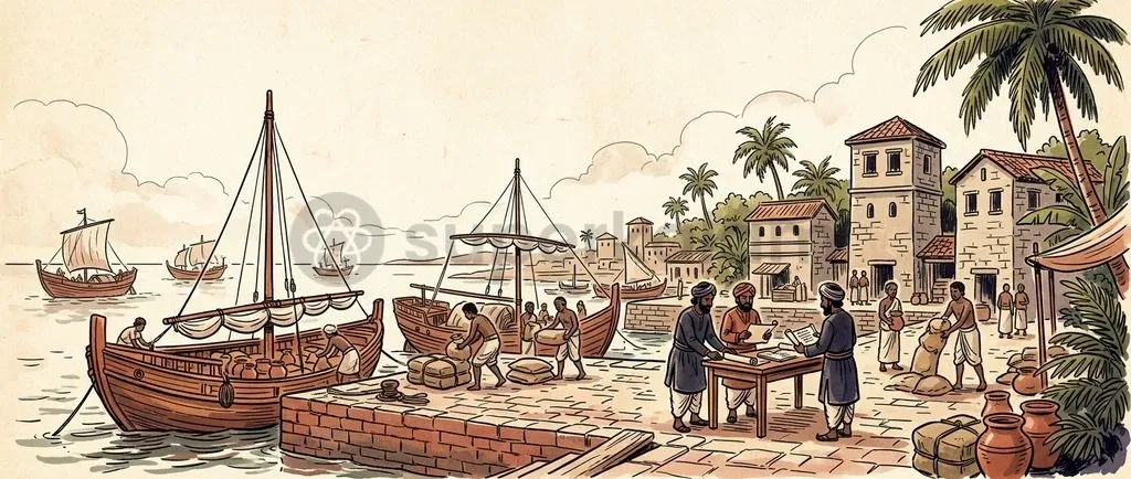
Ancient Tamil Sangam literature depicts Poompuhar as a flourishing early Chola capital and emporium that handled extensive domestic and international maritime commerce.
The Sangam classic Pattinappalai, composed by Katiyalur Uruttiran Kannanar, portrays Kaveripattinam as a bustling harbour with dedicated quarters for foreign merchants called Yavanas who spoke diverse tongues. Royal customs officials stamped incoming and outgoing cargo with the Chola royal tiger emblem to regulate oceanic trade.
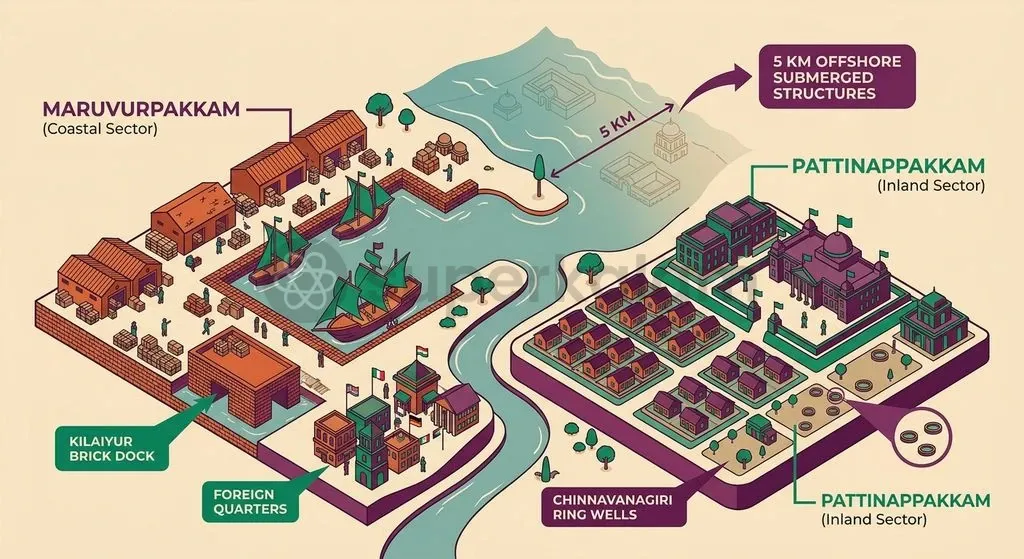
The post-Sangam epic Silappadikaram delineates the bipartite urban layout of the ancient metropolis. Classical literature records two distinct structural zones:
- Maruvurpakkam: The coastal market sector where sailors, foreign traders, and harbour artisans lived near the docks.
- Pattinappakkam: The elevated inland administrative sector reserved for royalty, ministers, and residential quarters.
The epic Manimekalai records that catastrophic ocean submergence destroyed Poompuhar. The text attributes the sea deluge (Kadalkol) to divine wrath after the city neglected the annual festival of Lord Indra.
Discuss with Superkalam
Which two distinct urban zones formed the bipartite layout of ancient Poompuhar according to the Silappadikaram?
Ask NowKey Underwater Archaeological Discoveries at Kaveripattinam
Archaeological excavations led by the Archaeological Survey of India and the National Institute of Oceanography have located substantial submerged and coastal structures around Poompuhar.
Onshore excavations conducted at Kilaiyur near Poompuhar revealed a semi-circular brick dock structure dating to the 3rd century BCE. Wooden mooring posts recovered from the site prove that early seagoing craft anchored directly within the estuarine channel.
Offshore surveys by the National Institute of Oceanography located submerged U-shaped stone structures at depths reaching 23 metres. These masonry remains sit approximately 5 kilometres from the modern shoreline, outlining the ancient urban footprint.
Marine divers documented terracotta ring wells in intertidal zones at Chinnavanagiri and offshore seabed locations. Underwater investigations also retrieved stamped 18th-century English East India Company lead ingots bearing marks of 'W. Blackett 1791' and '1792' from a historic shipwreck.
| Archaeological Feature / Discovery | Physical Location | Chronological Anchor | Historical & Commercial Significance |
|---|---|---|---|
| Semi-Circular Brick Dock | Kilaiyur (Onshore) | 3rd Century BCE | Confirms engineered wharves with wooden mooring posts for early Chola seafaring craft. |
| U-Shaped Masonry Structures | 5 km Offshore (23 m depth) | Ancient Early Historic | Indicates substantial submerged architectural complexes inundated by marine transgressions. |
| Terracotta Ring Wells | Chinnavanagiri & Offshore seabed | Early Historic | Proves the presence of terrestrial domestic habitation zones later submerged by sea-level shifts. |
| Torpedo Jar Fragments | Offshore Seabed | Parthian to Early Islamic Period | Direct material proof of liquid bulk trade with Mesopotamia and the Persian Gulf. |
| Stamped Lead Ingots | Offshore Shipwreck | 18th Century CE (1791/1792) | Demonstrates continuous multi-period maritime traffic and navigational hazards along the coast. |
What the Material Evidence Confirms: Trade with West Asia and the Greco-Roman World
Material artefacts recovered from the Poompuhar coast verify extensive maritime links spanning the Persian Gulf, the Red Sea, and the broader Mediterranean world.
The discovery of cylindrical torpedo jar fragments provides tangible proof of Persian Gulf commerce. Manufactured across Mesopotamia during the Parthian, Sasanian, and early Islamic periods, these vessels transported commodities like wine, bitumen, and oils across maritime routes.
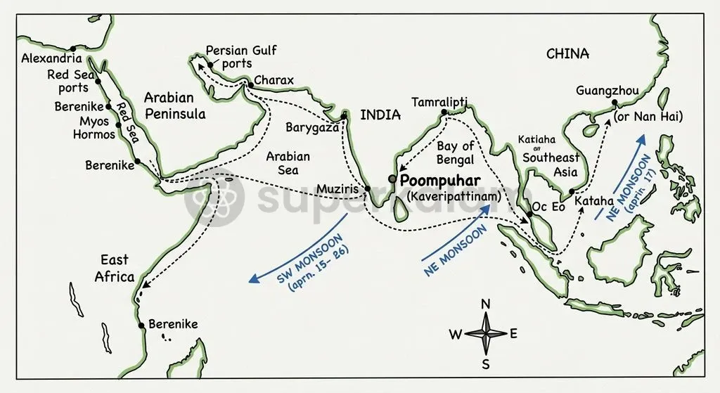
Classical Tamil texts provide complementary records of this trans-oceanic exchange. Pattinappalai records that Puhar imported Arabian horses by sea, black pepper across inland routes, gems and gold from northern mountains, and pearls from the southern seas.
Recoveries of Roman terra sigillata and Mediterranean amphorae along Coromandel coastal sites corroborate the maritime networks recorded in the Periplus of the Erythraean Sea. The Tamil Nadu State Department of Archaeology conserves many of these recovered artefacts at its Marine Archaeological Site Museum, established at Poompuhar in 1997.
Discuss with Superkalam
How does the geomorphological migration of the Cauvery River mouth explain the literary account of 'Kadalkol' found in the Manimekalai?
Ask NowScientific Methods in Marine Archaeology: Mapping Submerged Heritage
The Department of Science and Technology sanctioned a dedicated project to map and digitally reconstruct the submerged city of Poompuhar using advanced marine geo-archaeological technologies.
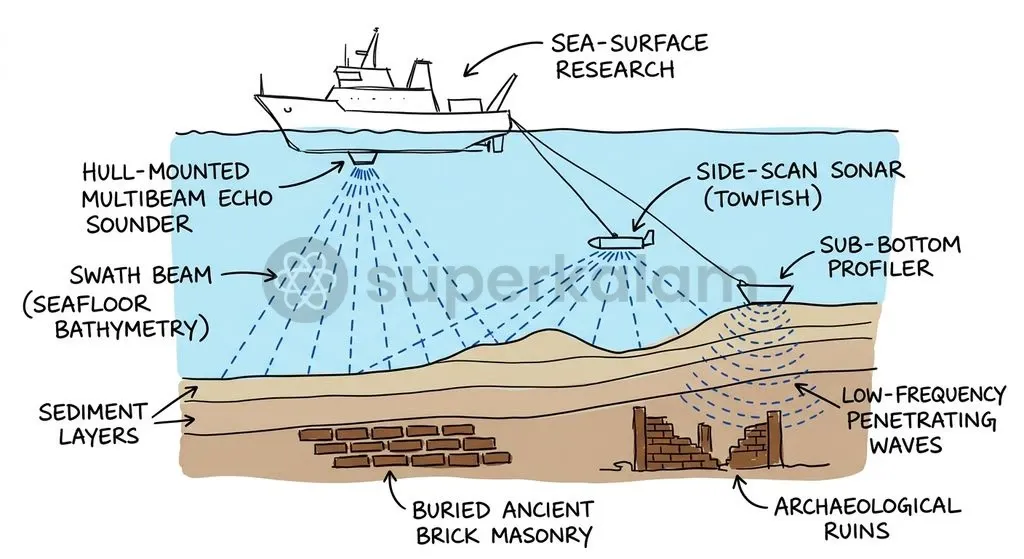
This ₹8.50 crore national initiative, led by Bharathidasan University, combines satellite remote sensing with underwater acoustic surveying. Modern marine geo-archaeology relies on three complementary exploration techniques:
- Multibeam Echo Sounders (MBES): Generates high-resolution bathymetric 3D digital elevation models to identify structural anomalies and sunken topography on the seabed.
- Side-Scan Sonar (SSS): Transmits wide acoustic pulses across the ocean floor to distinguish seabed surface textures and exposed architectural formations.
- Sub-Bottom Profilers (SBP): Employs low-frequency sound waves to penetrate sedimentary layers, mapping buried palaeochannels and sub-surface masonry beneath the seafloor.
Why Did Poompuhar Disappear? Evaluating Sea-Level Rise and Catastrophic Flooding
Geomorphological investigations indicate that the physical decline of ancient Poompuhar resulted from a combination of marine transgressions, delta shifting, and severe coastal erosion.
Studies conducted by the Geological Survey of India reveal that prolonged Holocene marine transgressions gradually submerged lower urban sectors. Rising sea levels inundated low-lying alluvial fringes of the Cauvery delta over several centuries.
Dynamic fluvial changes aggravated this oceanic submergence. The migration of the Cauvery River mouth altered sediment deposition patterns, stripping natural coastal barriers and accelerating shoreline retreat.
These scientific findings clarify the poetic descriptions found in Sangam and post-Sangam literature. The literary metaphor of Kadalkol in the Manimekalai reflects gradual, catastrophic flooding events that made the port uninhabitable.
Discuss with Superkalam
Analyse how the recovery of torpedo jars alongside Roman amphorae demonstrates the multi-regional character of early Chola maritime trade.
Ask NowRelevance for India’s Ancient Maritime Legacy and Modern Project Mausam
Project Mausam represents an interdisciplinary cultural initiative designed to reconnect India with thirty-nine Indian Ocean littoral states through shared historical and maritime heritage.
Launched by the Ministry of Culture and executed by the Archaeological Survey of India alongside the Indira Gandhi National Centre for the Arts, the initiative revives historical Indian Ocean monsoon routes. Poompuhar's material evidence proves that Indian ports served as central emporia connecting East Asia, South Asia, and the Greco-Roman world.
Documenting ancient port complexes strengthens India's cultural diplomacy and maritime security narrative in the Indo-Pacific. Excavations at sites like Kaveripattinam, Arikamedu, and Alagankulam provide the empirical foundation required to support trans-national UNESCO World Heritage nominations for ancient spice and monsoon routes.
Way Forward: Building a Dedicated Underwater Cultural Heritage Framework
India requires a comprehensive institutional framework to protect, research, and sustainably manage its extensive underwater cultural heritage across coastal and offshore waters.
Establishing a dedicated National Centre for Marine Archaeology under the Ministry of Culture would unify research currently split between the Archaeological Survey of India, the National Institute of Oceanography, and state archaeology departments. Coordinated inter-agency protocols are essential for rapid salvage operations during offshore infrastructural development.
Modernising deep-water exploration requires greater investment in autonomous underwater vehicles and high-resolution acoustic imaging systems. Developing specialised marine archaeological training programmes within central universities will supply the technical expertise needed to systematically survey the Bay of Bengal and Arabian Sea.
Ratifying and aligning domestic legislation with the UNESCO 2001 Convention on the Protection of the Underwater Cultural Heritage will prevent commercial looting of historic shipwrecks. Public-facing digital reconstructions and virtual museums can simultaneously enhance heritage awareness for civil society and competitive examinations.
Discuss with Superkalam
Evaluate the potential of underwater cultural heritage excavations at sites like Kaveripattinam to strengthen India's cultural diplomacy under Project Mausam.
Ask NowKey Takeaways
- Literary Corroboration: Offshore and onshore excavations at Poompuhar validate historical descriptions of the early Chola port of Kaveripattinam documented in Pattinappalai and Silappadikaram.
- Material Finds: Archaeological recoveries include a 3rd-century BCE brick wharf at Kilaiyur, offshore U-shaped masonry at 23-metre depths, terracotta ring wells, and West Asian torpedo jar fragments.
- Trans-Oceanic Commerce: Material evidence confirms maritime trade connections with Mesopotamia, the Persian Gulf, and the Roman Empire as recorded in the Periplus of the Erythraean Sea.
- Submergence Mechanisms: Geological evidence attributes the city's drowning to Holocene marine transgressions, coastal erosion, and Cauvery delta shifting, rather than a single mythic deluge.
- Diplomatic Strategic Relevance: Reviving Poompuhar’s maritime heritage provides historical ballast to India's Project Mausam, reinforcing cultural links across 39 Indian Ocean littoral nations.
Mains Question
"The physical decline of ancient Poompuhar reflects a complex interplay between prolonged Holocene marine transgressions and fluvial geomorphology." Elucidate in the light of underwater archaeological and geological findings. (10 Marks)
Evaluate NowMains Question
"Underwater archaeological discoveries along India's peninsular coast not only substantiate classical historical records but also provide empirical backing for initiatives like Project Mausam." Examine. (15 Marks)
Evaluate NowPractice MCQs
QUESTION 1
With reference to the urban layout and administration of ancient Poompuhar as described in Sangam and post-Sangam literature, consider the following statements:
- The epic Silappadikaram describes Maruvurpakkam as the coastal market sector where foreign traders and harbour artisans resided.
- Royal customs officials stamped incoming and outgoing cargo with the Chola royal tiger emblem according to the Pattinappalai.
- The epic Manimekalai attributes the city's oceanic submergence to divine wrath after the neglect of the annual festival of Lord Indra.
Which of the statements given above are correct?
QUESTION 2
Consider the following statements regarding marine and coastal archaeological discoveries at Kaveripattinam (Poompuhar):
- Onshore excavations at Kilaiyur revealed a semi-circular brick dock structure dating to the 3rd century BCE with wooden mooring posts.
- Offshore surveys by the National Institute of Oceanography located submerged U-shaped masonry structures at depths reaching 23 metres.
- Stamped lead ingots recovered from an offshore shipwreck bear 18th-century marks of the English East India Company.
Which of the statements given above is/are correct?
QUESTION 3
With reference to marine geo-archaeological exploration techniques used in mapping submerged heritage, consider the following statements:
- Multibeam Echo Sounders (MBES) generate 3D digital elevation models to identify structural anomalies and bathymetry.
- Side-Scan Sonar (SSS) employs low-frequency sound waves to penetrate sedimentary layers and map buried palaeochannels.
- Sub-Bottom Profilers (SBP) are used to detect buried sub-surface masonry beneath the ocean floor.
Which of the statements given above is/are correct?
QUESTION 4
Consider the following statements regarding ancient Indian Ocean trade evidence discovered along the Poompuhar coast:
- Torpedo jar fragments recovered from the seabed provide direct material evidence of bulk liquid trade with Mesopotamia and the Persian Gulf.
- Pattinappalai records that Puhar imported Arabian horses by sea and black pepper across inland routes.
- Discoveries of Roman terra sigillata and Mediterranean amphorae corroborate maritime links documented in the Periplus of the Erythraean Sea.
Which of the statements given above is/are correct?
QUESTION 5
Under the Ministry of Culture, which of the following executing bodies are tasked with reviving historical Indian Ocean monsoon routes through 'Project Mausam'?