PMFBY and WINDS: Why the Stalled Weather Station Rollout Matters for Crop Insurance
PMFBY and the WINDS weather station network explained: why the stalled rollout matters for crop insurance claims, smallholder payouts and climate resilience.
Oct, 2026
•9 min read
Overview
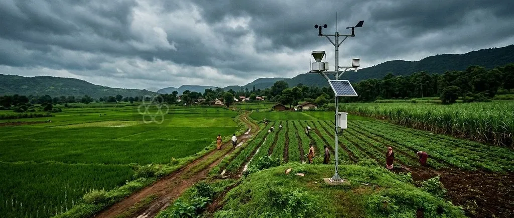
The rollout of the Weather Information Network Data Systems has stalled across multiple states. This leaves the Pradhan Mantri Fasal Bima Yojana without the hyper-local agro-meteorological network needed to eliminate basis risk and settle crop loss claims transparently.
Launched to establish automated weather infrastructure across rural India, the initiative faces severe operational roadblocks. Without panchayat-level observation grids, agricultural risk management continues to rely on coarse proxy measures and disputed manual assessments.
Why in the News? Bottlenecks in the WINDS Rollout
The Ministry of Agriculture and Farmers Welfare introduced the Weather Information Network and Data System in July 2023 to modernise crop risk valuation. However, execution has fallen far short of targets across the country, directly threatening the integrity of the Pradhan Mantri Fasal Bima Yojana (PMFBY).
Official data highlights the severe deployment deficit:
- Operational coverage gap: As of July 2026, the official rollout of WINDS recorded only 892 operational stations across seven adopting States and Union Territories, including Assam, Kerala, Uttar Pradesh, and Odisha, against 16,843 approved installation sites.
- Private delivery shortfall: According to a report by The Hindu in October 2026, over 96% of planned sensors remained uninstalled nationwide, with private concessionaires delivering only 113 Automatic Weather Stations out of a targeted 1,197 units.
This infrastructure gap denies insurance administrators the micro-climatic readings required for objective claim settlement. When weather anomalies ruin harvests, the absence of ground data leaves farmers trapped in administrative disputes and prolonged settlement delays.
Discuss with Superkalam
Can you recall the premium contribution caps paid by farmers for Kharif, Rabi, and commercial crops under PMFBY?
Ask Now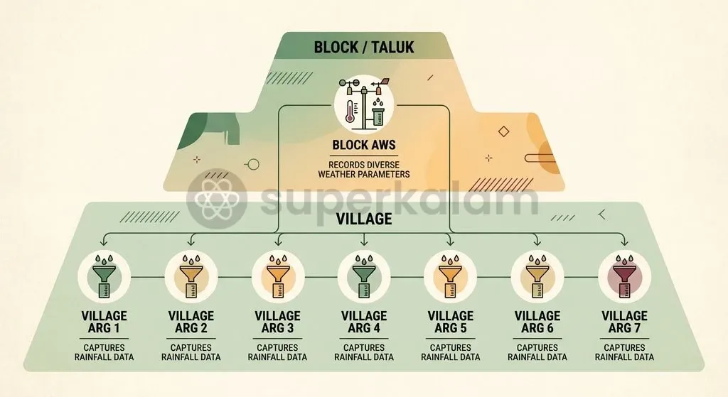
What is the WINDS Initiative and What Gap Does It Fill?
The Weather Information Network and Data System provides an open-access digital clearinghouse for hyper-local meteorological observations across agricultural zones. Designed by the Department of Agriculture and Farmers Welfare, the WINDS platform standardises data feeds generated by ground sensors to support parametric yield estimation and climate-resilience planning.
The technical framework established in the WINDS Manual mandates an unprecedented two-tier sensor density across rural India:
- Automatic Weather Stations (AWS): Deployed at every Block, Tehsil, or Taluk level to measure wind vector, ambient temperature, relative humidity, solar radiation, and barometric pressure.
- Automatic Rain Gauges (ARG): Installed at every Gram Panchayat level to record localised precipitation events with granular spatial resolution.
This infrastructure is engineered to complement allied interventions like the Yield Estimation System based on Technology (YES-TECH). Under YES-TECH guidelines issued by the Ministry of Agriculture, remote-sensing data receives a mandatory 30% minimum weightage for estimating paddy and wheat yields. This architecture demands ground-level meteorological calibration to function effectively.
Discuss with Superkalam
How does the 'Area Approach' in crop insurance lead to basis risk when hyper-local weather data is absent?
Ask NowWhy Has the Rollout of Automated Weather Stations Stalled Across States?
State-level deployment of the WINDS framework has encountered operational deadlocks rooted in procurement standards and land allocation disputes. Early implementation contracts divided sensor installations across three empanelled vendors—Skymet Weather Services, Ingen Technologies, and Azista Industries—tasked with deploying 49,313 ARGs and 1,197 AWSs across participating states under a public-private partnership framework, as reported by The Hindu in October 2026.
Three major operational roadblocks halted execution across state jurisdictions:
- Siting criteria shifts: Implementation stalled after the India Meteorological Department insisted that sensors must be situated on ground plots rather than single-storey rooftop spaces previously authorised under the 2023 WINDS manual, as reported by The Hindu in October 2026.
- Gram Panchayat land rejections: In Uttar Pradesh, state officials rejected 16,478 proposed sites out of 27,644 nominated locations due to non-conforming soil conditions, obstructions, or administrative duplication, as reported by The Hindu in October 2026.
- Federal subsidy friction: Delayed fiscal transfers between administrative tiers have complicated operational timelines. While the Union Government mandates a 12% annual interest penalty on states delaying their premium subsidy share, fiscal hesitation surrounding ongoing sensor maintenance costs has dampened state participation.
How Hyper-Local Data Deficits Hurt Farmers: Basis Risk and Claim Delays
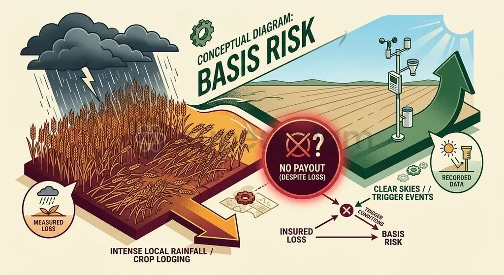
The lack of granular weather data introduces severe basis risk into index-linked agricultural insurance programmes. In parametric insurance, basis risk describes the mismatch where an insured farmer experiences catastrophic crop failure from a localised micro-climatic shock, yet receives no compensation because a distant reference station records normal weather conditions.
This observational void damages risk coverage across two primary mechanisms:
- Territorial averaging: The failure to deploy rain gauges at the Gram Panchayat level compels PMFBY administrators to depend on coarse district or block weather reference points. As highlighted by reporting in The Hindu in October 2026, averaging weather readings over wide territories masks localised cloudbursts, hail corridors, and short-term dry spells.
- Area Approach unit thresholds: Under the Area Approach, insurance settlements require an entire insurance unit—often an entire block or village panchayat cluster—to demonstrate collective yield reductions below historical thresholds. A farmer whose standing crop is flattened by a localised storm receives zero indemnity if nearby fields escape damage, transforming agricultural risk management into a source of financial distress.
Discuss with Superkalam
If a localized hailstorm damages one village but leaves the rest of the block unharmed, how does the current reference station model affect claim settlements?
Ask NowMeasuring Crop Loss: Traditional Crop Cutting Experiments vs Automated Weather Systems
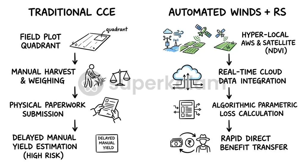
State agricultural directorates face logistical burdens in verifying crop losses through traditional empirical sampling methods. The Pradhan Mantri Fasal Bima Yojana historically depends on an Area Approach requiring over 6 million manual Crop Cutting Experiments (CCEs) each year.
| Evaluation Dimension | Manual Crop Cutting Experiments (CCEs) | Automated Weather Information Network (WINDS) |
|---|---|---|
| Operational Scale | Over 6 million physical harvesting trials conducted annually | Continuous digital capture across block AWS and panchayat ARG networks |
| Turnaround Time | Several months of manual data compilation and administrative verification | Real-time, machine-to-machine transmission to cloud registries |
| Vulnerability to Errors | High susceptibility to sampling bias, manual eye-estimation, and rent-seeking | Tamper-evident sensor telemetry with minimal local manual intervention |
| Verification Integrity | Supervised through the geo-tagged, time-stamped CCE-Agri mobile application | Calibrated against India Meteorological Department quality-control standards |
| State Adoption Discretion | Universally applied baseline yield assessment across all participating states | Variable integration; Madhya Pradesh adopted 100% tech weightage in 2025-26, whereas Uttar Pradesh applied 50% |
To curb field manipulation in traditional harvesting trials, the Ministry of Agriculture integrated the CCE-Agri mobile app into the National Crop Insurance Portal. This mandate enforces geo-tagged, time-stamped photography of field trials and permits insurance underwriters to observe physical crop cuttings directly.
Governance and Ethical Dimensions: Information Asymmetry in Farm Risk Protection
Information asymmetry between institutional underwriters and smallholder cultivators creates serious ethical concerns in farm safety nets. Private insurers deploy legal teams, actuarial models, and satellite analytics to evaluate claims. Smallholders, by contrast, lack direct access to verified meteorological records, as highlighted in a 2026 study by the Centre for Science and Environment.
This structural imbalance compounds risk across the agricultural sector:
- Marginal farmer vulnerability: Small and marginal cultivators constitute over 86% of Indian farmers, leaving the majority ill-equipped to challenge rejected claims or establish proof of localised inundation within statutory deadlines, as noted by the Centre for Science and Environment in May 2026.
- Unfair evidentiary burden: When weather logs remain confined to proprietary or inter-departmental silos, the burden of administrative proof falls entirely upon the insured farmer.
Timely financial compensation remains an economic necessity for climate-vulnerable agrarian households. To enforce institutional accountability, the central framework mandates a 12% annual interest penalty payable by insurance underwriters to farmers when claim payments are delayed past prescribed administrative windows.
Discuss with Superkalam
What are the primary differences between relying on physical Crop Cutting Experiments versus automated weather stations for crop loss determination?
Ask NowThe Way Forward: Fixing Federal and Operational Roadblocks in Weather Infrastructure
The Ministry of Agriculture and Farmers Welfare must resolve inter-agency technical disputes to accelerate weather station deployments. Adopting pragmatic siting guidelines that permit rooftop installations on public buildings—such as schools and panchayat bhawans—can bypass rural land-acquisition bottlenecks while preserving sensor telemetry standards.
Federal coordination mechanisms require immediate strengthening to sustain public-private investment flows:
- Standardised PPP frameworks: The State Level Coordination Committee on Crop Insurance (SLCCCI) must streamline long-term operational expenditure contracts to ensure vendors maintain remote sensors throughout their lifecycle.
- Unified data integration: Telemetry streams from operational AWS and ARG units should link directly with the Mahalanobis National Crop Forecast Centre (MNCFC) and the YES-TECH analytical engine.
- Farmer-facing transparency: Hyper-local weather logs must be published through open mobile dashboards, empowering village panchayats to audit weather indices and contest inaccurate yield thresholds.
Reforming the physical infrastructure of rural risk mitigation ensures that the Pradhan Mantri Fasal Bima Yojana is a dependable social safety net rather than a contested actuarial transaction.
Key Takeaways
- Uniform Premium Rates: Under PMFBY, farmers contribute a capped premium of 2% for Kharif crops, 1.5% for Rabi crops, and 5% for commercial or horticultural crops.
- Federal Subsidy Architecture: Premium subsidies beyond the farmer's contribution are divided 50:50 between the Centre and States, and 90:10 for North-Eastern States.
- Hyper-Local Design: The WINDS initiative mandates Automatic Weather Stations at every block and Automatic Rain Gauges at every Gram Panchayat to eliminate basis risk.
- Severe Deployment Deficits: As of July 2026, only 892 operational weather sensors were functioning across seven adopting states against 16,843 approved installation sites.
- Basis Risk Vulnerability: The absence of village-level weather telemetry forces the insurance mechanism to rely on coarse regional proxies, leaving localised crop destruction uncompensated.
- Tech-Driven Calibration: Allied tools such as YES-TECH remote-sensing models and the CCE-Agri mobile application are bridging verification gaps while sensor grids await completion.
Mains Question
"The transition from manual Crop Cutting Experiments to automated, hyper-local agro-meteorological grids is vital to eliminate basis risk in crop insurance." In light of the operational setbacks facing the WINDS initiative, critically analyse this statement. (15 Marks)
Evaluate NowMains Question
Evaluate the institutional and federal roadblocks hindering the deployment of hyper-local weather monitoring infrastructure under the Weather Information Network and Data System (WINDS). (10 Marks)
Evaluate NowPractice MCQs
QUESTION 1
With reference to the Pradhan Mantri Fasal Bima Yojana (PMFBY), consider the following statements:
- The maximum premium payable by farmers is capped at 2% for Kharif food and oilseed crops, and 1.5% for Rabi crops.
- For commercial and horticultural crops, farmers contribute a maximum premium capped at 5% across both seasons.
- The balance actuarial premium subsidy is shared equally (50:50) between the Centre and States across all Indian states without exception. Which of the statements given above is/are correct?
QUESTION 2
Consider the following statements regarding the Weather Information Network Data Systems (WINDS) framework:
- It mandates the deployment of Automatic Weather Stations (AWS) at the Gram Panchayat level.
- Automatic Rain Gauges (ARG) are designed to be installed at every Block, Tehsil, or Taluk level.
- It complements the Yield Estimation System based on Technology (YES-TECH), which assigns a mandatory minimum weightage of 30% to remote-sensing data for paddy and wheat yield estimation. Which of the statements given above is/are correct?
QUESTION 3
With reference to index-based agricultural insurance, 'basis risk' primarily refers to which of the following?
QUESTION 4
Consider the following statements regarding crop loss assessment under the Pradhan Mantri Fasal Bima Yojana (PMFBY):
- The scheme historically depends on an Area Approach requiring over 6 million manual Crop Cutting Experiments (CCEs) annually.
- The CCE-Agri mobile application enforces geo-tagged, time-stamped photography to supervise physical crop cuttings.
- In case of localized perils like hailstorms or cloudbursts, affected farmers are required to register claims within 72 hours of damage. Which of the statements given above are correct?
QUESTION 5
According to the article, which of the following factors contributed to the stalling of the Weather Information Network Data Systems (WINDS) rollout across states?
- A revision in siting criteria by the India Meteorological Department insisting on ground installations over rooftop spaces.
- Widespread rejection of proposed Gram Panchayat sites due to unsuitable soil conditions, obstructions, or duplication.
- Fiscal friction and delays regarding state subsidy transfers alongside maintenance cost liabilities. Select the correct answer using the code given below:
Related Blogs

National Strategic Trade Command Centre (NSTCC): What It Is, Functions and SCOMET Link
Oct, 2026
•9 min read

Women-Led Development in India: Meaning, Constitutional Basis and the Asset Gap
Oct, 2026
•9 min read

Reservation After Religious Conversion: What the Supreme Court Has Ruled and the Article 341 Debate
Oct, 2026
•10 min read


