NHAI 50,000-km High-Speed Corridor Master Plan: Design Norms & Impact
Standardised design norms for a 50,000-km access-controlled network aim to bridge India's logistics deficit while tackling severe highway safety challenges.
Sep, 2026
•9 min read
Overview
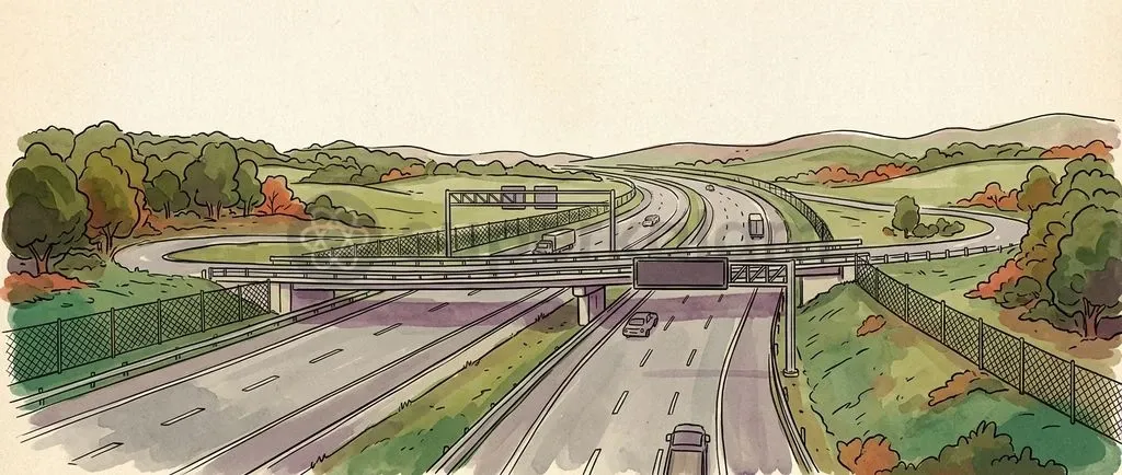
The National Highways Authority of India has introduced standardised design guidelines for a planned 50,000-kilometre access-controlled network under Vision 2047. This framework replaces piecemeal road widening with structured geometric standards, full grade separation, and intelligent traffic management.
As of September 2026, the central government is operationalising this framework to bring high-speed arterial connectivity within 100 to 125 kilometres of every citizen. It mandates dedicated utility ducts, crash-tested flush medians, and modular right-of-way planning. These steps directly resolve persistent freight bottlenecks and high accident rates across conventional routes.
The master plan underpins the National Logistics Policy target of cutting logistics costs from 12–14% of GDP down to global benchmarks near 8%.
Why Is NHAI's High-Speed Corridor Plan in the News?
The National Highways Authority of India released comprehensive design guidelines to standardise Detailed Project Reports for upcoming four-lane and six-lane access-controlled High-Speed National Highways.
As of September 2026, the central government is aligning trunk infrastructure with the Viksit Bharat 2047 roadmap to construct a 50,000 km access-controlled network.
The reform targets two structural problems across existing trunk routes:
- Disproportionate Fatality Burden: National Highways make up roughly 2% of India's road network but cause over 30% of traffic fatalities.
- Eliminating At-Grade Friction: Uncontrolled roadside entry, direct median cuts, and mixed slow-moving traffic generate severe safety hazards on conventional routes. The updated guidelines enforce complete physical access control to eliminate surface friction and lift heavy freight speeds on inter-state corridors.
Discuss with Superkalam
Recall the percentage share of traffic fatalities attributed to National Highways compared to their total share of India's road network length.
Ask NowUnderstanding the 50,000 km High-Speed Corridor Master Plan
The National Highway Master Plan 2047 establishes a 50,000-kilometre high-speed road network to bring rapid transit within 100 to 125 kilometres of every Indian citizen. This nationwide grid shifts planning away from isolated capacity expansion toward integrated freight arteries linking major economic hubs.
Key strategic pillars of this master plan include:
- Data-Driven Alignment: Planners identify corridors using data analytics from the Goods and Services Tax Network (GSTN freight data) and FASTag electronic toll records to map real origin-destination logistics flows. Aligning alignments with verified freight volumes maintains high capital utilisation and avoids stranded assets.
- Digital Highways Integration: Under the Digital Highways initiative, the National Highways Logistics Management Limited is embedding dedicated utility corridors to lay roughly 10,000 km of optic fibre cable along major expressways and high-speed corridors. This digital backbone supports intelligent transit systems and accelerates 5G coverage across rural hinterlands.
What Do the New Design Guidelines Actually Mandate?
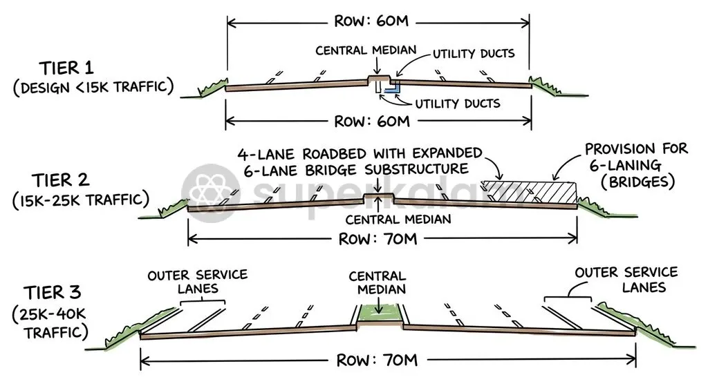
NHAI design guidelines establish strict geometric standards, right-of-way tiers, and access limits for all upcoming high-speed national highway projects. Detailed Project Reports must adhere to strict traffic-volume thresholds to ensure structured, long-term lane expansion:
- Daily traffic up to 15,000 vehicles: Requires a 4-lane highway with 4-lane structures within a 60-metre Right-of-Way (RoW).
- Daily traffic between 15,000 and 25,000 vehicles: Requires a 4-lane highway with 6-lane structures built from inception within a 70-metre RoW, enabling low-cost future widening.
- Daily traffic between 25,000 and 40,000 vehicles: Mandates a full 6-lane highway with 6-lane structures constructed immediately within a 70-metre RoW.
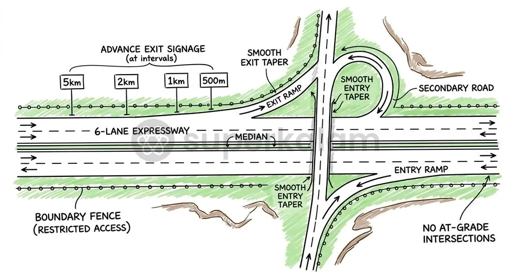
The guidelines prohibit all at-grade surface intersections and direct median openings. All entries and exits must pass through grade-separated interchanges. Standardised advance exit signage must appear at intervals of 5 km, 2 km, 1 km, and 500 metres before every interchange to assist high-speed navigation.
Engineers maintain physical separation by replacing raised concrete dividers with flush medians fitted with crash barriers or high-tension wire ropes. The entire alignment is protected by continuous outer perimeter fencing or a 1-metre boundary wall to prevent cattle entry and pedestrian crossings.
Corridors integrate the Advanced Traffic Management System (ATMS 2023), featuring Video Incident Detection and Enforcement Systems (VIDES) capable of identifying 14 distinct violation and hazard types. Dedicated workstations within Traffic Command and Control Centres share live feeds with state police for automated e-challan generation.
The design framework incorporates standardised wayside amenities (WSAs) every 40 to 60 km under Public-Private Partnership models. These hubs combine heavy vehicle parking, trauma care centres, EV charging infrastructure, and Village Haats to market regional artisan goods.
Discuss with Superkalam
Explain how data analytics from GSTN freight records and FASTag transactions optimize corridor alignment and prevent stranded highway assets.
Ask NowTraditional Highways vs Access-Controlled Expressways: Key Differences
Access-controlled corridors eliminate the operational bottlenecks, safety hazards, and ribbon development common to conventional open-access national highways. The table below contrasts conventional national highways with the newly mandated access-controlled high-speed corridors:
| Feature | Conventional National Highways (Brownfield) | Access-Controlled High-Speed Corridors |
|---|---|---|
| Access Management | Open access with multiple direct local entries and surface cuts | Strictly closed access via grade-separated interchanges |
| Right-of-Way (RoW) | Variable, typically 30 to 45 metres | Standardised at 60 to 70 metres with utility ducts |
| Commercial Vehicle Speeds | Average 20–30 km/h due to local congestion and friction | Sustained 80–100 km/h uninterrupted transit speeds |
| Intersection Design | At-grade intersections with traffic signals or roundabouts | Grade-separated underpasses, flyovers, and trumpet loops |
| Median & Edge Protection | Concrete curbs, unshielded edges, prone to cattle entry | Flush medians with wire ropes, continuous perimeter fencing |
| Intelligent Monitoring | Manual monitoring or isolated CCTV cameras | Centralised ATMS 2023 with VIDES covering 14 hazard types |
Widening existing brownfield highways presents lower initial land acquisition hurdles. However, it suffers from commercial encroachment, urban ribbon development, and severe traffic disruptions during construction.
In contrast, building greenfield access-controlled corridors requires substantial upfront capital for land acquisition under the RFCTLARR Act, 2013. Yet it delivers straight geometric alignments, unhindered freight transit, and modular long-term expansion capacity.
NHAI prioritises greenfield corridors along dense national freight routes to bypass congested urban clusters. It reserves brownfield widening for secondary feeder links where land availability is constrained.
Economic and Strategic Value: Boosting Logistics and Growth (GS-3)
The 50,000-kilometre corridor network directly advances the National Logistics Policy by lowering transit times and cutting trade transaction costs. Key economic and ecological benefits include:
- Logistics Cost Reduction: India's logistics costs stand at roughly 12–14% of GDP, creating a competitive gap against developed economies operating near global benchmarks of 8%.
- Elevated Commercial Speeds: Access-controlled alignments raise heavy commercial vehicle operating speeds to 80–100 km/h, compared to historical averages of 20–30 km/h on non-access routes. Higher truck turnaround speeds cut fuel wastage, lower fleet expenses, and improve supply chain reliability.
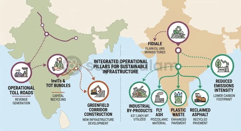
- Sustainable Construction Footprint: In FY 2023–24, NHAI utilised over 631 lakh metric tonnes of recycled materials, including fly ash, plastic waste, and reclaimed asphalt pavement. Despite a 20% expansion in highway construction volume, GHG emissions intensity dropped from 1.0 to 0.8 MTCO2e per kilometre.
- Wildlife and Ecological Protection: Corridors passing through forest tracts incorporate mandatory animal underpasses and elevated viaducts. These eco-ducts adhere to Wildlife Institute of India guidelines to maintain ecological connectivity in sensitive wildlife corridors.
Discuss with Superkalam
Analyse the trade-offs between brownfield highway widening and greenfield access-controlled corridor construction regarding capital outlay, land acquisition, and commercial vehicle transit speeds.
Ask NowKey Hurdles: Land Acquisition, Financing, and Environmental Impact
Infrastructure delivery on this scale faces structural hurdles across acquisition, fiscal sustainability, and inter-agency enforcement:
- High Land Acquisition Costs: Land acquisition under the RFCTLARR Act, 2013 represents 30% to 40% of the total capital cost of greenfield high-speed corridors. Linear acquisition frequently encounters compensation litigation, delayed social impact assessments, and local resistance.
- Fiscal and Debt Sustainability: Following elevated market borrowings during Bharatmala Phase-I, NHAI has pivoted away from pure debt-financed engineering contracts towards private capital mobilisation through Toll-Operate-Transfer (TOT) bundles and the National Highway Infra Trust (InvIT). Monetising operational stretches generates equity for upcoming greenfield construction.
- Enforcement and Ecological Auditing: Real-time detection capabilities of VIDES under ATMS 2023 rely on state police departments to process digital e-challans and enforce penalties across state borders. Managing ecological fragmentation also demands continuous post-construction environmental audits so that dedicated wildlife corridors function as designed.
The Road Ahead: Building a Future-Ready Transport Grid
Future highway development must balance rapid network expansion with multi-modal logistics integration, fiscal prudence, and climate-resilient engineering:
- Multi-Modal Synchronisation: The 50,000 km corridor network must integrate with the PM Gati Shakti National Master Plan to create seamless links with railway Dedicated Freight Corridors, inland waterways, and major maritime ports.
- Private Capital Mobilisation: Asset monetisation models like InvITs and TOT concessions must be scaled up to channel private pension and insurance funds into operational road assets, insulating NHAI from balance-sheet stress.
- Multi-Utility Corridors: Embedding utility ducts for optic fibre cables and power lines transforms highways into multi-utility infrastructure corridors, supporting digital connectivity across tier-2 and tier-3 manufacturing hubs.
- Climate-Resilient Standards: Highways require climate-resilient pavement engineering, expansive rainwater harvesting, and recycled industrial inputs. Combining strict geometric design, automated safety monitoring, and multi-modal integration ensures the Vision 2047 road network directly drives national economic competitiveness.
Discuss with Superkalam
Propose institutional mechanisms to bridge the enforcement gap between NHAI's automated ATMS/VIDES incident detection and state police e-challan execution.
Ask NowKey Takeaways
- NHAI's Vision 2047 targets a 50,000 km access-controlled high-speed corridor network designed to place a high-speed transit node within 100 to 125 km of every citizen.
- New design guidelines mandate a 60-metre RoW for up to 15,000 vehicles daily and a 70-metre RoW with 6-lane structures for higher traffic volumes.
- Access-controlled corridors eliminate at-grade crossings and median cuts, requiring grade-separated interchanges, flush medians, and continuous perimeter fencing.
- Advanced safety features include ATMS 2023 with VIDES detecting 14 hazard types, paired with standardised wayside amenities every 40 to 60 km.
- The network supports the National Logistics Policy goal of reducing logistics costs from 12–14% of GDP to roughly 8% by boosting freight speeds to 80–100 km/h.
- Core structural challenges include land acquisition costs absorbing 30–40% of project expenditure, requiring asset monetisation via TOT bundles and InvITs to preserve fiscal health.
Mains Question
"India's logistics costs stand at roughly 12–14% of GDP, creating a competitive disadvantage against developed economies operating near 8%." In light of the National Highway Master Plan 2047, discuss how access-controlled high-speed corridors can transform India's freight logistics while addressing highway safety hazards. (15 Marks)
Evaluate NowMains Question
"The transition from conventional brownfield highway widening to greenfield access-controlled corridors marks a structural shift in linear infrastructure planning." Critically analyse the institutional, financial, and environmental challenges associated with operationalising NHAI's 50,000-km master plan. (10 Marks)
Evaluate NowPractice MCQs
QUESTION 1
Regarding the design guidelines and Right-of-Way (RoW) mandated by NHAI for High-Speed National Highways, consider the following statements:
- For corridors with daily traffic up to 15,000 vehicles, a 4-lane highway with 4-lane structures is required within a 60-metre RoW.
- For corridors with daily traffic between 15,000 and 25,000 vehicles, a 4-lane highway with 6-lane structures must be built within a 70-metre RoW.
- Standardised advance exit signage is mandated at intervals of 5 km, 2 km, 1 km, and 500 metres prior to every interchange. Which of the statements given above are correct?
QUESTION 2
With reference to the technological and operational features of NHAI's access-controlled high-speed corridors, consider the following statements:
- The corridors integrate the Advanced Traffic Management System (ATMS 2023) equipped with Video Incident Detection and Enforcement Systems (VIDES) capable of identifying 14 distinct hazard types.
- The Digital Highways initiative involves embedding utility corridors to lay approximately 10,000 km of optic fibre cable.
- At-grade intersections and direct median openings are permitted at regular intervals to maintain access for rural traffic. Which of the statements given above is/are correct?
QUESTION 3
Consider the following statements regarding the strategic objectives of the National Highway Master Plan 2047:
- Corridors are identified using origin-destination freight analytics derived from GSTN freight data and FASTag records.
- The master plan aims to bring high-speed road connectivity within 100 to 125 kilometres of every Indian citizen.
- The corridor network supports the National Logistics Policy goal of reducing logistics costs from 12–14% of GDP to global benchmarks near 8%. Which of the statements given above are correct?
QUESTION 4
With reference to environmental sustainability measures implemented across NHAI highway projects, consider the following statements:
- In FY 2023–24, NHAI recorded a decrease in GHG emissions intensity from 1.0 to 0.8 MTCO2e per kilometre.
- Over 631 lakh metric tonnes of recycled materials, including fly ash and plastic waste, were utilised in FY 2023–24.
- Mandatory animal underpasses and viaducts in forest tracts are designed in adherence to Wildlife Institute of India guidelines. Which of the statements given above are correct?
QUESTION 5
According to PRS Legislative Research findings cited in the context of NHAI greenfield high-speed corridors, land acquisition under the RFCTLARR Act, 2013 accounts for what proportion of total project capital cost?