National Waterways in India: Why 111 Routes Struggle for Freight Viability
Despite 111 routes declared under the 2016 Act, only 32 operate commercially as seasonal siltation and high transshipment costs curb inland freight viability.
Oct, 2026
•9 min read
Context
India's statutory expansion under the National Waterways Act, 2016 declared 111 rivers and canals as national transport corridors. However, structural hydrological deficits and heavy transshipment penalties have restricted commercially viable freight operations to a small fraction of these routes. Inland water transport offers an exceptionally low line-haul operating cost per tonne-kilometre compared to rail and road.
Yet statutory declaration alone does not resolve the physical realities of Indian monsoonal rivers. Without year-round navigable water depth, integrated river ports, and seamless intermodal connectivity, national waterways cannot achieve meaningful commercial scale. This divide exposes an ambition gap where blanket legislative reclassification outpaces both hydrological viability and cargo-handling economics.
Why in the News?
As of October 2026, data from the Ministry of Ports, Shipping and Waterways indicates that inland water transport accounts for only around 2% of India's domestic modal freight share. This nominal share persists despite total cargo movement on National Waterways reaching an all-time high of 218 million metric tonnes in FY 2025-26.
Cargo volumes expanded from 145.84 million metric tonnes in FY 2024-25, but bulk transport remains heavily concentrated in coal, fly ash, sand, and iron ore along fewer than three dozen active channels. This modest modal share stands in sharp contrast to global freight systems, highlighting the persistent operational gap between statutory ambition and commercial fairway viability.
Discuss with Superkalam
Recall the total number of National Waterways declared under the 2016 Act and how many of them are currently operational for commercial traffic.
Ask NowThe Legal Shift: What the National Waterways Act of 2016 Changed
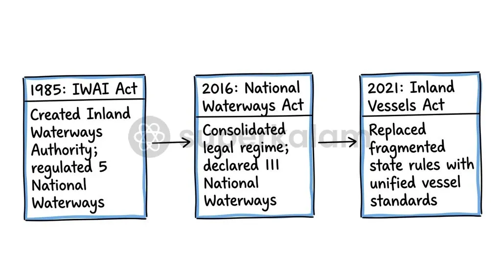
Parliament enacted the National Waterways Act, 2016 to consolidate fragmented navigation laws and expand central jurisdiction over India's river systems. Before this legislative overhaul, the Inland Waterways Authority of India (IWAI)—established in October 1986 under the Inland Waterways Authority of India Act, 1985—managed just five standalone National Waterways.
| Dimension | Before 2016 Framework | National Waterways Act, 2016 Regime |
|---|---|---|
| Declared Corridors | 5 bespoke National Waterways | 111 consolidated waterways |
| Network Coverage | Isolated river segments (~4,000 km) | 20,187 kilometres across 24 states and Union Territories |
| Statutory Architecture | Individual Acts per waterway | Single unified statutory enactment |
| Regulatory Oversight | Fragmented state-centre coordination | Central development mandate under IWAI statutory authority |
The 2016 Act brought 20,187 kilometres of riverine and canal waterways under central jurisdiction to expedite capital dredging, fairway aids, and river terminal construction.
In 2021, Parliament complemented this framework by passing the Inland Vessels Act, 2021, repealing the colonial-era Inland Vessels Act, 1917. The new legislation introduced unified vessel survey standards, standardised crew certification, and established a digital registry across states through the centralised Jalyan and Navic portal.
The Viability Triage: Why Only Two Dozen Routes Carry Cargo
The Inland Waterways Authority of India reports that out of the 111 declared National Waterways, only 32 waterways are currently operational for commercial shipping, navigation, and passenger movement. The remaining routes face severe techno-economic unviability, lacking the hydrological discharge, commercial traffic catchment, and natural depth required to sustain self-financing navigation channels.
Policy planners have shifted from blanket network expansion toward selective corridor triage:
- Prioritised Core Corridors: Heavy institutional investment focuses on proven river arteries, led by National Waterway 1 on the Ganga-Bhagirathi-Hooghly system, National Waterway 2 along the Brahmaputra, and National Waterway 3 traversing the West Coast Canal.
- Selective Phased Rollout: Official announcements in the Union Budget 2026-27 set targets to operationalise 20 additional National Waterways over a five-year horizon, concentrating on high-potential industrial and mineral routes such as National Waterway 5 in Odisha.
- Non-viable Channel De-prioritisation: Numerous seasonal peninsular rivers declared under the 2016 Act run dry for eight months of the year, rendering commercial fairway maintenance economically unjustifiable.
Discuss with Superkalam
Explain why the ₹1.06 per tonne-kilometre line-haul cost advantage of barges often disappears when delivering goods to non-riverfront industries.
Ask NowFreight Economics: Waterways Against Rail and Road
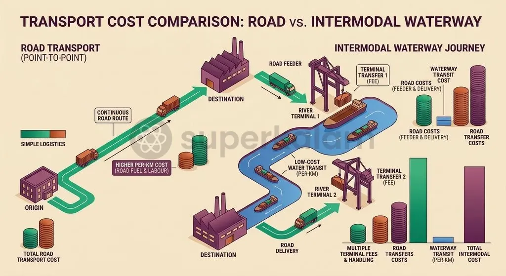
Line-haul transport economics strongly favour inland water transport over land-based freight alternatives. Government logistics evaluations show that moving one tonne of cargo by barge costs approximately ₹1.06 per kilometre, compared to roughly double that cost on Indian Railways and triple that amount over the national highway network.
| Transport Metric | Inland Waterways | Indian Railways | Road Transport | | :--- | :--- | :--- | | Line-haul Cost (per tonne-km) | ₹1.06 | ~₹1.40–₹2.10 (approx. 2× barge) | ~₹2.50–₹3.20 (approx. 3× barge) | | Fuel Efficiency | Highest bulk payload per unit | High volume efficiency | Low per-unit efficiency | | Terminal Transshipment | High double-handling penalty | Moderate terminal handling | Low point-to-point friction | | Door-to-Door Viability | Dependent on intermodal link | Railhead to warehouse link | Direct point-to-point service |
The cost advantage of water transport erodes rapidly outside point-to-point riverfront industries. According to freight logistics assessments by the Asian Development Bank and the Ministry of Ports, Shipping and Waterways, inland water transit suffers from severe first-and-last mile logistics friction.
River barges cannot deliver directly to inland factories or consumption centres. Cargo must be transshipped between road trucks, railway wagons, and river berths at multi-modal terminals. Consequently, the added expenses of crane handling, storage, and local cartage frequently cancel out savings gained during the water leg.
Physical Bottlenecks: Siltation, Water Depth, and Seasonality
Indian river hydrology presents acute technical hurdles to reliable year-round commercial navigation. The primary physical constraint is maintaining a consistent Least Available Depth (LAD), which drops precipitously during dry, lean seasons as upstream irrigation barrages divert surface water. Barges drawing 2.5 to 3.0 metres of draught risk grounding during lean periods without massive, continuous capital dredging.
Morphological and infrastructural bottlenecks further complicate operations:
- Monsoon Siltation and Thalweg Shifts: Monsoonal runoff deposits massive silt loads that alter braided riverbed morphology, forcing IWAI to conduct recurrent hydrographic thalweg surveys across 22 operational waterways to locate shifting navigable fairways.
- Cross-River Clearance Limitations: Low vertical air draft under older road bridges, railway crossings, and seasonal pontoon bridges blocks standard container vessels and tall roll-on/roll-off (Ro-Ro) barges.
- Digital Navigation Countermeasures: To mitigate these hazards, IWAI deployed the Portal for Asset and Navigation Information (PANI), the IWAI Vessel Tracker, and Naudarshika as the National River Traffic and Navigation System to relay real-time depth measurements and fairway hazards.
Discuss with Superkalam
If a manufacturing corridor is planned along a seasonal peninsular river, what physical hydrological criteria must planners evaluate before opting for waterway transport?
Ask NowEcological Costs: River Dredging and Aquatic Habitats
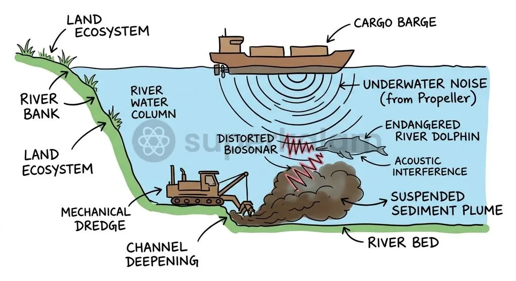
Intensive fairway engineering along natural river channels generates severe environmental externalities across vulnerable freshwater ecosystems. Proceedings before the National Green Tribunal revealed that capital and maintenance dredging strips away riverbed benthic microhabitats, spikes water turbidity, and can remobilise sequestered toxic heavy metals such as arsenic into open river water.
The environmental impact is especially pronounced on the endangered Gangetic River Dolphin (Platanista gangetica), an apex freshwater mammal that inhabits segments of National Waterway 1, including the Vikramshila Gangetic Dolphin Sanctuary. The species is virtually blind and relies entirely on biosonar navigation and echolocation clicks to navigate, communicate, and forage.
Research reviewed by the IUCN Cetacean Specialist Group and the Wildlife Conservation Trust demonstrates that motorised cargo vessels and dredging rigs generate low-frequency underwater acoustic noise that jams dolphin biosonar, triggering chronic acoustic displacement and collision risks.
Rethinking Jal Marg: What It Takes to Make Waterways Work
The Jal Marg Vikas Project (JMVP) illustrates the structural shift required to modernise inland water transport into a commercially viable, ecologically conscious logistics network. Implemented by IWAI across a 1,390-kilometre stretch of National Waterway 1 between Haldia and Varanasi with technical and financial assistance from the World Bank, JMVP modernises navigation capacity through dedicated infrastructure.
Under this project, authorities constructed three Multi-Modal Terminals at Varanasi in Uttar Pradesh, Sahibganj in Jharkhand, and Haldia in West Bengal, alongside an Intermodal Terminal at Kalughat in Bihar. A modern navigational lock at Farakka in West Bengal was built to ease transit between the upstream Ganga and downstream Hooghly channels. River Information Services (RIS) have been commissioned across three sectors—Haldia-Farakka, Farakka-Patna, and Patna-Varanasi—utilising 4 control stations and 13 base stations to orchestrate vessel traffic.
To expand beyond heavy industrial bulk cargo, development frameworks must combine large-scale connectivity with community-level freight systems:
- Multimodal Integration: The PM Gati Shakti National Master Plan maps inland river terminals directly to the Western and Eastern Dedicated Freight Corridors and national highway networks to eliminate transshipment bottlenecks.
- Local Economic Linkages: The Arth Ganga concept (JMVP-II) introduces over 50 community jetties, farmers' mandis, and small-scale Ro-Ro operations along riverbanks to connect agrarian output with national markets.
- River Basin Prioritisation: Capital expenditure should focus on year-round perennial corridors with guaranteed cargo demand, avoiding costly maintenance dredging on hydrologically unviable seasonal rivers.
Discuss with Superkalam
Compare the operational viability of perennial Himalayan river channels with seasonal peninsular waterways in terms of siltation, Least Available Depth, and seasonality.
Ask NowKey Takeaways
- The National Waterways Act, 2016 expanded India's declared waterways from 5 to 111 across 20,187 kilometres, but only 32 waterways are commercially operational today.
- Inland water transport accounts for roughly 2% of India's domestic modal freight share, trailing global counterparts such as China (
9%) and the European Union (7%). - Waterways deliver significant line-haul savings at approximately ₹1.06 per tonne-kilometre, but first-and-last mile transshipment friction and double handling often offset these cost benefits.
- Primary operational hurdles include seasonal discharge drops, dynamic monsoon siltation, and inadequate bridge clearances, requiring regular thalweg tracking and digital monitoring tools like PANI and Naudarshika.
- River engineering and vessel noise disrupt freshwater ecosystems and impair the echolocation and biosonar navigation of the endangered Gangetic River Dolphin.
- The World Bank-assisted Jal Marg Vikas Project demonstrates that selective corridor-level modernisation—integrating multimodal terminals, modern locks, River Information Services, and PM Gati Shakti linkages—is essential to make waterways commercially viable.
Mains Question
"Statutory declaration alone does not resolve the physical realities of Indian monsoonal rivers." In light of the National Waterways Act, 2016, critically examine the structural bottlenecks that prevent declared waterways from achieving commercial freight viability. (15 Marks)
Evaluate NowMains Question
Evaluate the environmental and ecological externalities associated with intensive fairway engineering and dredging along National Waterway 1. (10 Marks)
Evaluate NowPractice MCQs
QUESTION 1
Regarding the statutory and institutional framework governing inland water transport in India, consider the following statements:
- The Inland Waterways Authority of India (IWAI) was established under the National Waterways Act, 2016.
- The Inland Vessels Act, 2021 repealed the colonial-era Inland Vessels Act, 1917 to introduce unified vessel survey standards and a digital registry.
- The National Waterways Act, 2016 brought 111 waterways across 24 states and Union Territories under central jurisdiction.
Which of the statements given above are correct?
QUESTION 2
Consider the following statements regarding the economics and modal share of inland water transport (IWT) in India:
- Moving cargo by barge costs approximately ₹1.06 per tonne-kilometre, which is lower than the line-haul costs of both rail and road transport.
- Inland water transport accounts for around 9% of India's total domestic freight modal share, matching that of China.
- The line-haul cost advantage of inland waterways is frequently counterbalanced by double-handling and transshipment penalties at multi-modal terminals.
Which of the statements given above is/are correct?
QUESTION 3
With reference to the physical and infrastructural constraints of Indian National Waterways, consider the following statements:
- The primary hydrological constraint is maintaining Least Available Depth (LAD), which falls significantly during lean dry seasons.
- Monsoonal runoff causes heavy siltation and shifting of river thalwegs, necessitating periodic hydrographic surveys.
- Digital navigation systems like PANI and Naudarshika have eliminated the physical bottleneck posed by low vertical clearances under cross-river road and railway bridges.
Which of the statements given above is/are correct?
QUESTION 4
Consider the following statements regarding the environmental impacts of river channel engineering for navigation:
- Capital dredging can strip riverbed benthic habitats and remobilise toxic heavy metals such as arsenic.
- The Gangetic River Dolphin relies primarily on visual cues rather than biosonar navigation in freshwaters.
- Low-frequency acoustic noise from motorised cargo barges and dredging rigs can interfere with the echolocation clicks of Platanista gangetica.
Which of the statements given above are correct?
QUESTION 5
Which of the following portals/systems deployed by the Inland Waterways Authority of India (IWAI) functions as the National River Traffic and Navigation System to relay real-time fairway hazards and navigation data?