Kotia Border Dispute: Supreme Court Status Quo and Article 131 Limits
Beyond endless contempt petitions lies a structural truth: judicial status quo cannot substitute for constitutional boundary demarcation under Article 3.
Oct, 2026
•11 min read

Overview
The long-standing Kotia border dispute between Odisha and Andhra Pradesh encompasses 21 contested hill villages where decades of competing territorial claims have created a severe administrative impasse under Supreme Court status quo orders. Both state governments provide parallel welfare schemes and hold conflicting local elections. Yet judicial remedies have reached structural limits because boundary delimitation remains the exclusive constitutional domain of Parliament.
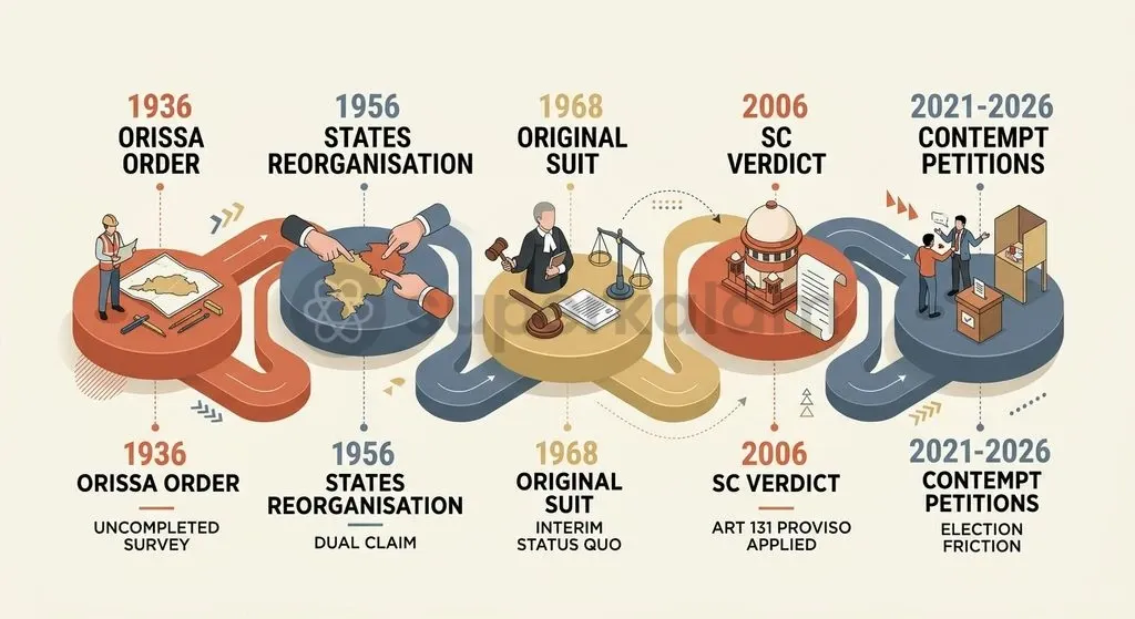
Originating from uncompleted physical boundary surveys during the 1936 creation of Orissa Province, the conflict persisted through the States Reorganisation Act, 1956. In 1968, the Supreme Court recorded an interim status quo undertaking. It eventually dismissed Odisha's original suit in 2006 under the proviso to Article 131, leaving an unresolved operational vacuum on the ground. Resolving the stalemate requires activating consultative federal bodies like the Inter-State Council rather than filing repeated contempt petitions.
Why in the News? The Enduring Stand-Off in the Kotia Cluster
As of October 2026, the Odisha government filed a fresh contempt petition in the Supreme Court against Andhra Pradesh over panchayat election notifications in the disputed Kotia border cluster. According to an official press briefing by the Odisha Revenue Department, the litigation challenged an order issued on 10 October 2026 by Andhra Pradesh authorities to conduct Zilla Parishad and Panchayat Samiti elections across the contested villages.
Odisha contended that notifying rural local body elections unilaterally breached the Supreme Court's long-standing status quo directions governing the region. This legal challenge followed an earlier contempt petition instituted in February 2021, when the Andhra Pradesh State Election Commission successfully conducted gram panchayat polls in three border villages.
The enduring stand-off exposes an analytical tension central to Indian federalism: judicial status quo orders cannot substitute for substantive boundary delimitation under Article 3 of the Constitution. By freezing administrative lines without demarcation, judicial holding actions incentivise competitive welfare populism while leaving the core territorial dispute unresolved.
Background: How the Odisha-Andhra Pradesh Border Dispute Began
The territorial dispute over the Kotia gram panchayat traces its origins to the Government of India (Constitution of Orissa) Order, 1936. When British authorities carved Orissa Province out of the Madras Presidency, administrative demarcation teams failed to execute a physical boundary survey across 28 remote hill villages situated in the Eastern Ghats.
Cartographic ambiguity deepened following Indian independence and the redrawing of administrative boundaries along linguistic lines. The enactment of the Andhra State Act, 1953 and subsequent adjustments under the States Reorganisation Act, 1956 established Andhra Pradesh without definitive cadastral demarcation of the tract.
Both states asserted concurrent jurisdiction over 21 of the 28 villages in the Kotia cluster. Odisha administered the villages under Pottangi tehsil within Koraput district. Andhra Pradesh integrated the identical settlements into Salur mandal within Vizianagaram district (now part of Parvathipuram Manyam district).
The table below outlines the statutory and administrative milestones that consolidated the territorial contest:
| Year | Milestone / Enactment | Administrative Impact on Kotia Cluster |
|---|---|---|
| 1936 | Government of India (Constitution of Orissa) Order, 1936 | Carved out Orissa Province; left 28 hill villages unsurveyed on the ground. |
| 1953 | Andhra State Act, 1953 | Created Andhra State from Telugu-speaking districts of Madras Presidency. |
| 1956 | States Reorganisation Act, 1956 | Reorganised state boundaries without settling overlapping revenue claims over 21 villages. |
| 1968 | Supreme Court Status Quo Undertaking | Recorded mutual undertaking in Original Suit No. 10 of 1968 to preserve the administrative baseline. |
| 2006 | Supreme Court Dismissal ((2006) 9 SCC 591) | Dismissed suit under the Article 131 proviso; left field administration in legal limbo. |
Understanding Status Quo: The Supreme Court Orders of 1968 and 2006
The Supreme Court of India entered the dispute in 1968 when Odisha filed Original Suit No. 10 of 1968 under Article 131 of the Constitution. The suit sought a formal declaration of sovereign ownership over the Kotia tract alongside a permanent injunction restraining Andhra Pradesh authorities from entering the area.
On 2 December 1968, the Supreme Court recorded a mutual undertaking given by both state governments. Under this arrangement, both parties agreed to maintain strict status quo regarding administrative jurisdiction and physical boundary positions on the ground.
Discuss with Superkalam
Which 1936 British administrative order failed to conduct a physical survey of the 28 hill villages in the Eastern Ghats, triggering the Kotia dispute?
Ask NowThe 1968 suit assumed that judicial arbitration under Article 131 could settle title between two federating units. However, holding an interim status quo for nearly four decades proved destabilising, as neither state developed permanent infrastructure for fear of contempt proceedings.
On 30 March 2006, a three-judge bench delivered its final verdict in State of Orissa v. State of A.P., dismissing Original Suit No. 10 of 1968. The ruling established two key constitutional points:
- Bar on Pre-Constitution Disputes: Because the dispute originated from 1936 orders, the proviso to Article 131 barred the Supreme Court from exercising original jurisdiction.
- Exclusive Parliamentary Prerogative: The court observed that the power to alter, establish, or determine inter-state boundaries resides exclusively with Parliament under Article 3 and Article 4.
Because the suit was dismissed on jurisdictional grounds without fixing a border, both states treated the judgment as extending the 1968 status quo, creating an enduring operational vacuum.
On the Ground: Welfare Competition, Dual Voting, and Administrative Clashes
The prolonged judicial status quo has transformed the Kotia gram panchayat into an arena of competitive welfare patronage. Because neither state holds undisputed authority, both deploy parallel welfare schemes to assert de facto possession.
This administrative competition plays out across several daily services:
- Duplicate Documentation: Residents receive dual voter identity cards, dual ration cards under the public distribution system, and parallel social security pensions from both administrations.
- Parallel Infrastructure: Rural electrification offers a visible example, with power utilities from both states erecting duplicate poles and supply grids along identical village lanes.
- Conflicting Elections: In February 2021, the Andhra Pradesh State Election Commission conducted local panchayat elections in three Kotia villages: Phagunasineri, Ganjeipadar, and Phatusineri.
- Jurisdictional Paralysis: Police stations in Koraput district (Odisha) and Parvathipuram Manyam district (Andhra Pradesh) routinely file cross-complaints or disclaim territorial responsibility during criminal investigations.
Discuss with Superkalam
How does the proviso to Article 131 circumscribe the Supreme Court's original jurisdiction over historical territorial disputes?
Ask NowOdisha's contempt petition in February 2021 argued that conducting rural elections altered the administrative baseline preserved by the Supreme Court since 1968. Andhra Pradesh countered that extending local self-governance under Part IX of the Constitution was an administrative obligation that did not infringe territorial property rights.
Constitutional Mechanisms for Inter-State Border Disputes: Article 131 vs Article 263
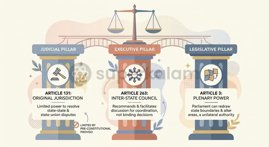
The Indian Constitution establishes distinct judicial and executive mechanisms to resolve inter-state disputes through Article 131, Article 3, and Article 263. Understanding the jurisdictional division between these provisions is essential for analysing boundary adjudication.
Article 131 grants the Supreme Court original and exclusive jurisdiction in legal disputes between the Government of India and states or between two or more states. However, this judicial route carries two structural hurdles:
- Existence of a Legal Right: The suit must involve a concrete question of law or legal right, excluding purely political or historical grievances.
- The Pre-Constitution Proviso: The proviso to Article 131 explicitly bars original jurisdiction over disputes arising out of any treaty, agreement, covenant, or instrument executed before the commencement of the Constitution.
Discuss with Superkalam
If two states notify conflicting local body elections in a contested border zone under Part IX, how should the State Election Commissions coordinate to avoid administrative confrontation?
Ask NowThe exclusion of pre-constitutional boundary disputes under the Article 131 proviso means that historical cartographic defects cannot be resolved through judicial decrees. While Article 131 determines existing legal rights, it cannot create new territorial borders.
The constitutional architecture vests the sole authority to alter state boundaries in the Union Parliament under Article 3. Parliament may by law form new states, increase or diminish state areas, or alter boundaries, requiring only Presidential reference to affected state legislatures for their views.
To address disputes outside adversarial courtrooms, Article 263 empowers the President to establish an Inter-State Council mandated to investigate and advise upon inter-state friction. Statutory Zonal Councils established under Sections 15 to 22 of the States Reorganisation Act, 1956 provide an additional institutional forum. However, because Odisha sits in the Eastern Zonal Council while Andhra Pradesh belongs to the Southern Zonal Council, coordinated bilateral dialogue requires special joint ministerial sittings.
The table below contrasts the judicial and non-judicial mechanisms available under the Constitution:
| Feature | Judicial Route (Article 131) | Executive / Advisory Route (Article 263) | Legislative Route (Article 3) |
|---|---|---|---|
| Governing Authority | Supreme Court of India | Inter-State Council (Presidential order) | Union Parliament |
| Jurisdictional Scope | Adjudication of existing legal rights | Inquiry, discussion, and policy advice | Altering, increasing, or diminishing state boundaries |
| Enforceability | Binding judicial decree or interim injunction | Non-binding recommendations | Binding central statute |
| Primary Limitation | Proviso bars pre-constitutional treaties and pacts | Lack of permanent enforcement teeth | Requires central political consensus |
Comparative Perspective: How Kotia Mirrors Belagavi and Assam-Meghalaya Disputes
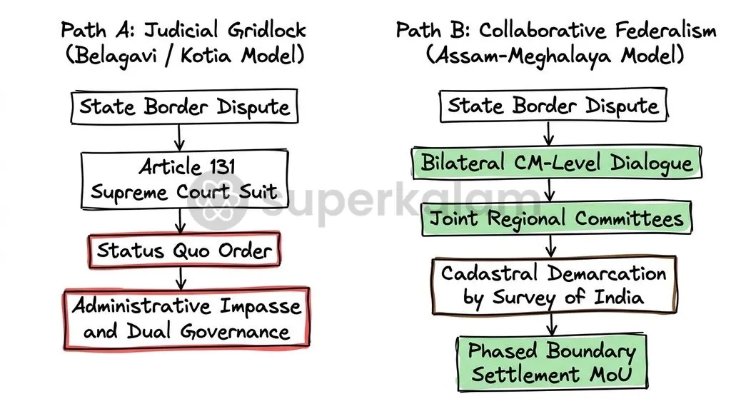
Border conflicts in Kotia, Belagavi, and the Assam-Meghalaya frontier demonstrate how historical cartographic ambiguities challenge Indian federalism across multiple boundaries. Each flashpoint illustrates a distinct interaction between judicial litigation and political negotiation:
- Belagavi (Judicial Impasse): Maharashtra filed Original Suit No. 4 of 2004 under Article 131 before the Supreme Court, claiming 865 Marathi-speaking settlements in Karnataka. Earlier, the Union Government appointed the Mahajan Commission in October 1966. Its August 1967 recommendations were accepted by Karnataka but rejected by Maharashtra, showing that commissions cannot enforce settlements without statutory enactment under Article 3.
- Assam-Meghalaya (Negotiated Settlement): Covering 12 contested sectors along an 884-kilometre boundary arising from the Assam Reorganisation (Meghalaya) Act, 1969, both states formed joint regional committees instead of relying on status quo orders.
- Bilateral Demarcation: On 29 March 2022, the Chief Ministers of Assam and Meghalaya signed a Memorandum of Understanding in New Delhi, settling 6 disputed sectors covering 36.79 square kilometres. The Survey of India then received an official mandate to conduct cadastral surveys and erect boundary pillars.
Ethical and Governance Dimensions: The Plight of Citizens in Border Limbo
The administrative stalemate in Kotia inflicts severe democratic and developmental costs on resident Kondh tribal communities. Behind the spectacle of dual ration cards lies an acute governance deficit that impairs basic constitutional guarantees.
This legal ambiguity creates concrete developmental hurdles:
- Uncertain Land Tenure: Because revenue jurisdictions remain contested, land revenue registries from both states refuse to issue authenticated Record of Rights (RoR).
- Loss of Credit and Rights: Local farmers cannot establish formal tenure, preventing them from securing institutional agricultural credit, availing crop insurance, or obtaining individual forest rights titles under the Forest Rights Act, 2006.
- Capital Investment Deficit: While both states offer duplicative dry rations and cash transfer schemes to extract political loyalty, neither state invests in long-term capital assets such as secondary schools, piped drinking water, or secondary healthcare centres.
Discuss with Superkalam
Why do interim judicial status quo orders in territorial disputes often foster competitive welfare populism rather than administrative stability?
Ask NowCitizens are effectively reduced to passive pawns in a contest of competitive sovereignty. Duplicate welfare benefits are a political substitute for substantive constitutional entitlements, leaving fundamental developmental rights compromised.
Way Forward: Moving from Judicial Gridlock to Institutional Dialogue
Resolving the Kotia border dispute requires transitioning from adversarial litigation in the Supreme Court to structured political dialogue under constitutional bodies. Decades of litigation demonstrate that status quo orders preserve friction rather than build resolution.
A bilateral breakthrough occurred on 9 November 2021 when the Chief Ministers of Odisha and Andhra Pradesh convened a summit and agreed to form an institutional joint committee mechanism headed by their respective Chief Secretaries. Activating this committee requires moving through concrete administrative phases:
- Joint Cadastral Ground Surveys: The Ministry of Home Affairs must mandate the Survey of India to execute an impartial, drone-assisted cadastral mapping of all 28 villages in the Kotia tract.
- Inter-State Council Mediation: Activating the Inter-State Council under Article 263 allows the Union to serve as a neutral federal mediator, steering negotiations beyond regional political pressures.
- Joint Zonal Council Meetings: Convening a joint session of the Eastern and Southern Zonal Councils under the States Reorganisation Act, 1956 provides a statutory forum to draft a shared administrative charter.
- Parliamentary Boundary Enactment: Once both state cabinets approve negotiated territorial adjustments, Parliament must pass a definitive boundary reorganisation statute under Article 3.
Pending a permanent legislative settlement, both state governments should establish a temporary joint administrative authority over the Kotia cluster. Harmonising welfare delivery, school curricula, and policing protocols through a shared administrative council will protect tribal livelihoods while formal constitutional boundaries are finalised.
Key Takeaways
- The Kotia territorial conflict involves 21 contested hill villages, originating from uncompleted physical boundary surveys during the enactment of the Government of India (Constitution of Orissa) Order, 1936.
- In 1968, the Supreme Court recorded a mutual status quo undertaking in Original Suit No. 10 of 1968, but dismissed the litigation in 2006 under the Article 131 proviso, which bars original jurisdiction over pre-constitutional disputes.
- The Supreme Court ruled in 2006 that the power to demarcate, alter, or establish inter-state boundaries belongs exclusively to the Union Parliament under Article 3 of the Constitution.
- Decades of judicial status quo produced competitive welfare populism, dual voter registrations, and parallel rural polls, leaving Kondh tribal residents without secure land records or primary infrastructure.
- Durable resolution requires shifting away from repeated contempt petitions toward political dialogue via the Inter-State Council (Article 263) and cadastral boundary demarcation led by the Survey of India.
Mains Question
"Judicial status quo orders cannot substitute for substantive boundary delimitation under Article 3 of the Constitution." In the context of the Kotia border dispute, critically examine how reliance on judicial holding actions affects inter-state relations and field governance. (10 Marks)
Evaluate NowMains Question
The constitutional architecture under Article 131, Article 3, and Article 263 provides distinct pathways for addressing inter-state friction. Discuss how the structural limitations of Article 131 necessitate the activation of consultative federal institutions to resolve protracted inter-state boundary disputes. (15 Marks)
Evaluate NowPractice MCQs
QUESTION 1
Regarding the original jurisdiction of the Supreme Court under Article 131 of the Constitution of India, consider the following statements:
- It extends to any dispute between the Government of India and one or more States involving a question of legal right.
- The proviso to Article 131 bars the Supreme Court's jurisdiction over disputes arising out of any treaty, agreement, or instrument executed prior to the commencement of the Constitution.
- The Supreme Court has the constitutional authority under Article 131 to redraw and alter inter-state territorial boundaries. Which of the statements given above are correct?
QUESTION 2
With reference to the constitutional mechanisms governing inter-state relations and territorial boundaries in India, consider the following statements:
- Parliament can by law alter the boundaries of any State only after obtaining the binding consent of the concerned State Legislature under Article 3.
- The Inter-State Council established under Article 263 possesses statutory powers to issue binding adjudicatory decrees on boundary disputes.
- Statutory Zonal Councils were established under the provisions of the States Reorganisation Act, 1956. Which of the statements given above is/are correct?
QUESTION 3
Consider the following statements regarding the Kotia border dispute:
- The dispute involves contested hill villages located in the Eastern Ghats claimed by both Odisha and Andhra Pradesh.
- In State of Orissa v. State of A.P. (2006), the Supreme Court dismissed Odisha's original suit on the merits after demarcating the cadastral boundaries.
- The cartographic origins of the dispute trace back to uncompleted physical boundary surveys under the Government of India (Constitution of Orissa) Order, 1936. Which of the statements given above is/are correct?
QUESTION 4
In the context of Indian federalism, which constitutional provision explicitly bars the original jurisdiction of the Supreme Court from entertaining disputes arising out of pre-Constitution treaties, agreements, or covenants?
QUESTION 5
Consider the following pairs of administrative units involved in the Kotia border dispute:
- Pottangi tehsil : Koraput district
- Salur mandal : Parvathipuram Manyam district
- Contested villages : Eastern Ghats Which of the pairs given above are correctly matched?