Kashipur ASI Excavation: Govisana, Xuanzang and PGW
Stratigraphy at Kashipur's Drona Sagar mound proves foothill urbanisation was continuous, linking Iron Age Painted Grey Ware to seventh-century Govisana.
Oct, 2026
•8 min read
Context
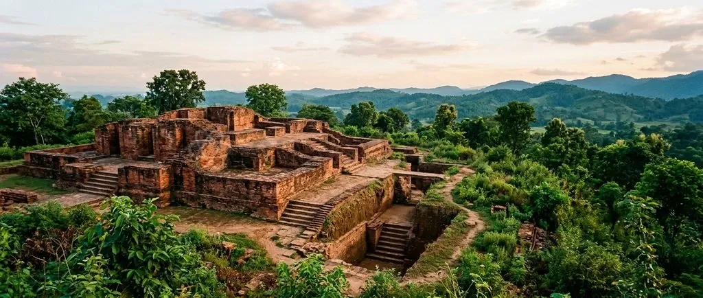
The Archaeological Survey of India's ongoing work at the Drona Sagar mound in Kashipur, Uttarakhand, establishes a continuous stratigraphic sequence. This sequence links Iron Age Painted Grey Ware settlements directly with the historical kingdom of Govisana, visited by Chinese pilgrim Xuanzang in the seventh century.
Material stratigraphy at the site demonstrates genuine foothill urbanisation. It traces protohistoric ceramic traditions, early historic urban phases, and medieval structural complexes. Field evidence independently tests rather than mirrors ancient travelogues, shedding light on ancient trade corridors along the northern foothills.
Why Kashipur Is in the News
The Archaeological Survey of India has mounted renewed field assessments at the Drona Sagar mound in Kashipur, located in Uttarakhand's Udham Singh Nagar district. As of March 2025, heritage managers are reassessing the site's structural remains to shield vulnerable protohistoric and historic layers from rapid infrastructure growth and weather damage.
Archaeological interest in Kashipur centres on its identification with ancient Govisana, a regional political and religious hub described in seventh-century Chinese pilgrimage records. Recent scholarly assessments focus on two primary structural horizons:
- Ceramic remnants of Painted Grey Ware, which mark protohistoric occupation.
- Extensive burnt-brick architecture dating from later historical periods.
These physical deposits let historians trace how early settlements in northern India evolved. They chart the shift from rural Iron Age hamlets to fortified administrative centres. Stratigraphy at the site provides concrete field evidence, showing how sub-Himalayan routes integrated into the wider Indo-Gangetic cultural network.
Where Is Govisana? The Historical Identity of Kashipur
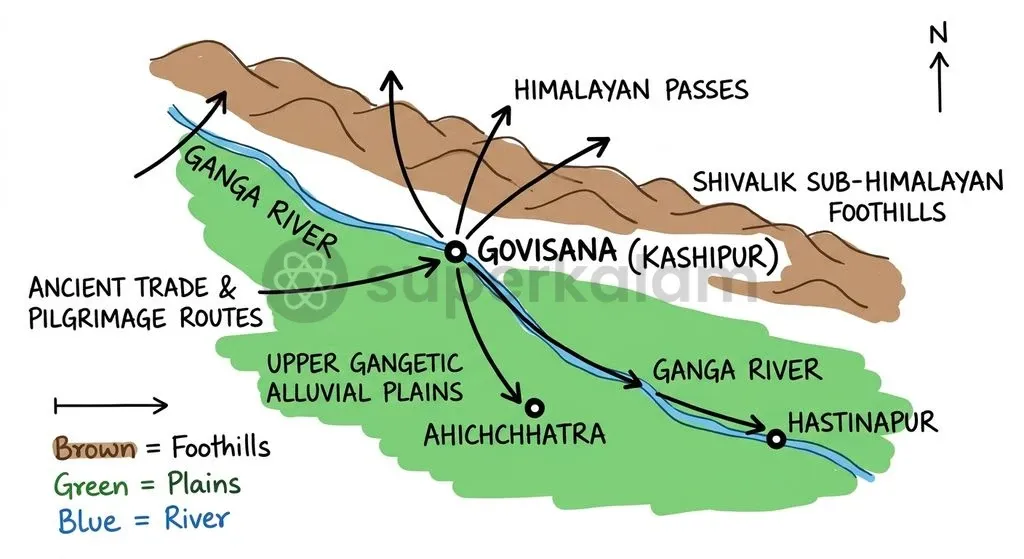
Kashipur occupies a strategic geographic position in the Tarai-Bhabhar foothill belt of modern Uttarakhand. The modern settlement holds the prominent Drona Sagar mound, an extensive earthwork enclosing structural debris and a water tank linked by local folklore to the teacher Dronacharya.
Historical geography links this mound to the ancient territory of Govisana. The settlement controlled communication routes linking the upper Gangetic plains to the central Himalayan interior. In the nineteenth century, colonial surveys proposed equating Kashipur's mounds with the city described by foreign pilgrims, relying on topographic orientation and relative travel distances.
Regional topography gave Govisana clear ecological and commercial advantages:
- Alluvial runoff: Fertile sub-Himalayan water flows supported steady agrarian yields.
- Forest and mineral wealth: Immediate access to the Bhabhar belt provided timber, stone, and highland minerals.
- Trans-Himalayan corridors: Natural passes enabled transit between lowland agricultural plains and mountain communities.
Material remains at Drona Sagar confirm that the site was far more than an isolated redoubt. It operated as a vibrant nodal centre that knit together lowland agricultural economies and highland trade.
Discuss with Superkalam
Recall the Chinese name under which Xuanzang documented the ancient kingdom of Govisana in his travelogue, Si-Yu-Ki.
Ask NowXuanzang's Travelogue: What the Chinese Pilgrim Recorded
Xuanzang, the seventh-century Chinese Buddhist monk who travelled across India, documented Govisana under the name Kiu-pi-shwang-na. His travelogue, the Si-Yu-Ki (Buddhist Records of the Western Regions), provides an eyewitness account of the kingdom's geography, religious architecture, and administrative life.
The pilgrim described Govisana as a territory measuring several thousand li in circuit. Its populous capital held both Buddhist monastic communities and thriving non-Buddhist shrines. Xuanzang recorded several distinct features:
- Multiple Buddhist monasteries, largely housing monks of the Hinayana tradition.
- Dozens of Deva temples where varied religious groups worshipped side by side.
- An ancient stupa attributed to the Mauryan Emperor Ashoka, built beside an established monastery holding sacred relics.
- Regular crop yields, a temperate climate, and a hospitable local populace.
Xuanzang's account shows that seventh-century Govisana sustained an active culture of institutional co-existence. Large stupas stood alongside Brahmanical temples, indicating steady royal and mercantile patronage along this foothill route.
Discuss with Superkalam
How did the natural geography of the Tarai-Bhabhar belt facilitate Govisana's emergence as an ancient trade corridor between the plains and the mountains?
Ask NowMaterial Culture on the Ground: The Significance of Painted Grey Ware
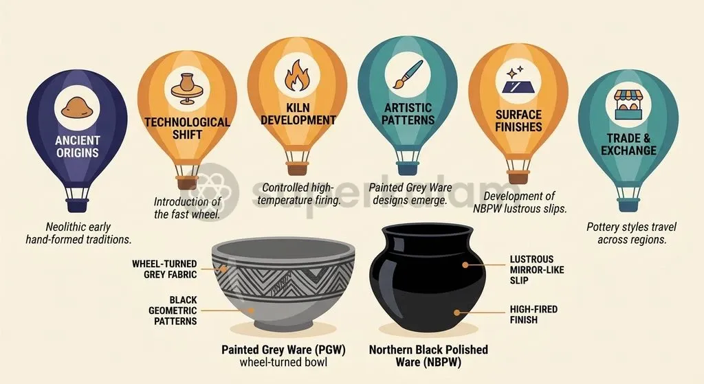
Excavations at Kashipur have uncovered stratified pottery fragments belonging to the Painted Grey Ware culture. These finds place the earliest occupation of the site squarely in the North Indian Iron Age. Potters made Painted Grey Ware from well-levigated alluvial clay, shaped it on a fast wheel, and fired it in a reducing kiln to produce an ash-grey fabric with black geometric designs.
Settlement layers containing this pottery correlate with the eastward expansion of agro-pastoral communities and early iron metallurgy across the Indo-Gangetic divide. Unearthing these diagnostic sherds at Drona Sagar extends the verified foothill reach of Iron Age culture into the Kumaon terai.
The sequence at Kashipur reflects the broader socio-economic transition of ancient Northern India, moving from village communities to dense urban hubs:
| Cultural Phase | Key Ceramic Typology | Diagnostic Architectural and Material Markers | Broader Historical Setting |
|---|---|---|---|
| Protohistoric / Iron Age | Painted Grey Ware (PGW) | Earthen floors, mud plaster with reed impressions, early iron implements | Agro-pastoral expansion, early metallurgical mastery, Later Vedic horizon |
| Early Historic Phase | Northern Black Polished Ware (NBPW) and associated coarse red wares | Burnt-brick foundations, terracotta ring wells, early metallic currency | Second Urbanisation, rise of Mahajanapadas, Mauryan administrative integration |
| Post-Mauryan to Classical Phase | Polished red wares, stamped pottery | Elaborate brick walls, lime plaster, moulded ornamental terracotta plaques | Trade expansion, Kushana and Gupta era material horizons, institutional patronage |
| Early Medieval Phase | Coarse utilitarian ceramics, residual glazed fragments | Expansive brick temple platforms, carved stone niches, regional defensive walls | Regional dynastic rule, transformation of classical pilgrimage sites, Govisana kingdom |
Layers of Northern Black Polished Ware sitting directly above or beside transitional strata prove that Kashipur joined the trade circuits of the Second Urbanisation. The sequence confirms that the settlement did not spring up suddenly in the seventh century as a pilgrim station. It grew on deep protohistoric roots.
Discuss with Superkalam
Why can an archaeologist not accept a foreign travelogue's attribution of a monument to Emperor Ashoka as conclusive historical fact without material verification?
Ask NowLayer by Layer: Understanding Archaeological Stratigraphy at Kashipur
Stratigraphy at Drona Sagar provides an unbroken cross-section of human habitation. Trenches show how successive generations built directly over older structural levels, often laying larger burnt bricks over protohistoric mud platforms.
The occupational profile exposed at Kashipur unfolds across several clear cultural layers:
- Basal Horizon: The lowest occupational levels yield Painted Grey Ware fragments accompanied by bone tools and simple iron slag, reflecting early Iron Age domestic life.
- Intermediate Horizon: Strata overlying the basal deposits reveal Northern Black Polished Ware alongside terracotta figurines and stratified brick alignments from the early centuries of the Common Era.
- Monumental Structural Horizon: The upper layers expose extensive brick structural complexes, including temple plinths, decorative mouldings, and a vast fortified perimeter dating from the post-Gupta to early medieval centuries.
Upper levels reveal massive burnt-brick architecture with decorative chamfering and protective coatings. These expansive platforms match the scale of public ritual structures, corroborating the large religious compounds noted in early travel accounts.
Discuss with Superkalam
In light of urban expansion pressures around protected sites like Drona Sagar, propose a policy framework balancing statutory AMASR buffer rules with local developmental needs.
Ask NowTexts vs Spade: What Archaeology Can and Cannot Prove
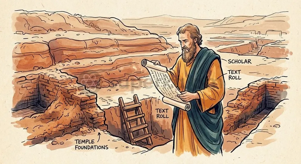
Correlating ancient texts with excavation requires methodological discipline. Literature offers qualitative background, regional names, and institutional accounts. In contrast, material remains supply exact spatial coordinates, stratigraphic chronologies, and economic baselines.
Pilgrim travelogues such as Xuanzang's often reflect theological ideals, royal genealogies, and formulaic distances. Archaeological digging unearths everyday tools, utilitarian ware, and structural phases that rarely carry sectarian tags or royal labels.
Archaeologists maintain clear distinctions between texts and physical evidence:
- Literary attributions: A pilgrim's reference to an Ashokan stupa cannot prove a third-century BCE date without stratigraphic or epigraphic backing.
- Folklore vs stratigraphy: Local legends linking the Drona Sagar tank to epic figures preserve cultural memory, not empirical Iron Age chronologies.
- Topographic alignment: Equating modern Kashipur with Xuanzang's Govisana makes geographical sense, yet identifying specific monasteries demands diagnostic antiquities rather than bare mounds.
- Absence of epigraphy: Without inscribed reliquaries, seals, or royal copper plates, identifying the sectarian affiliation of excavated temples remains an educated inference.
The Kashipur excavations show that material stratigraphy is an independent corrective to literary geography. Physical evidence outlines the real functional lifespan of foothill hubs without relying on literal readings of pilgrimage itineraries.
Way Forward: Protecting Uttarakhand’s Sub-Himalayan Heritage
Safeguarding Kashipur's archaeological heritage requires balancing preservation laws with local urban expansion. Because the Drona Sagar mound lies inside an expanding town, housing construction, altered drainage, and agricultural levelling threaten unexcavated peripheral deposits.
Under the AMASR Act framework, the standard prohibited area extends 100 metres from the protected limits of a centrally protected monument or site, while the regulated area extends up to 300 metres.
Preserving the site requires a coordinated management approach:
- Enforcing construction setbacks through digital cadastral mapping and tighter municipal building permits around the Drona Sagar boundary.
- Running non-invasive geophysical surveys, including Ground-Penetrating Radar (GPR), to map buried structures without disturbing damp strata.
- Consolidating exposed ancient brickwork against seasonal monsoon runoff and severe foothill frost weathering.
- Supporting local community involvement by incorporating ancient Govisana into regional cultural tourism routes.
Rigorous heritage management must ensure that foothill excavations continue to enrich India's archaeological record while staying protected from urban encroachment.
Key Takeaways
- The Drona Sagar mound at Kashipur, located in Uttarakhand's Udham Singh Nagar district, contains archaeological remains identified with the ancient city of Govisana.
- Chinese pilgrim Xuanzang documented seventh-century Govisana as a prosperous kingdom featuring active Buddhist monasteries, an Ashokan stupa tradition, and varied religious establishments.
- Excavation deposits yielded Painted Grey Ware (PGW), confirming that human habitation at the site extends back to the North Indian Iron Age.
- Stratigraphic sequences demonstrate continuous regional occupation from protohistoric settlements through the Northern Black Polished Ware period to medieval brick temple complexes.
- Methodological analysis highlights that material archaeology must act as an independent empirical test of ancient literary accounts rather than a passive verification tool.
- Under the AMASR Act framework, the standard prohibited area extends 100 metres from the protected limits of a centrally protected monument or site, while the regulated area extends up to 300 metres.
Mains Question
"Material stratigraphy serves as an essential independent corrective to ancient travelogues and literary geography." In the light of excavations at Drona Sagar (Govisana), elucidate. (10 Marks)
Evaluate NowMains Question
The integration of sub-Himalayan corridors into the wider Indo-Gangetic network illustrates the multifaceted nature of early Indian urbanisation. Examine the ecological, commercial, and structural evidence uncovered at ancient Govisana. (15 Marks)
Evaluate NowPractice MCQs
QUESTION 1
With reference to the archaeological site of Drona Sagar at Kashipur, consider the following statements:
- The basal occupational horizon is characterized by the presence of Northern Black Polished Ware alongside early iron implements.
- The site provides material evidence of continuous human occupation linking the Iron Age to the early medieval period.
- The ceramic assemblage of Painted Grey Ware found at the site was fired in an oxidising kiln producing a characteristic bright red slip.
Which of the statements given above is/are correct?
QUESTION 2
Regarding Xuanzang's account of the ancient kingdom of Govisana (Kiu-pi-shwang-na), consider the following statements:
- The travelogue records the presence of Hinayana Buddhist monasteries co-existing with non-Buddhist Deva temples.
- The pilgrim documented a stupa attributed to the Mauryan Emperor Ashoka located beside a monastery.
- Xuanzang noted that the kingdom suffered from chronic droughts and sustained an unwelcoming populace.
Which of the statements given above are correct?
QUESTION 3
Consider the following statements regarding the regulatory framework for protecting archaeological heritage at Kashipur:
- Under the AMASR Act framework, the prohibited area extends up to 100 metres from the protected limits of a centrally protected site.
- The regulated area under the statutory framework extends up to 300 metres beyond the protected boundary.
- Digital cadastral mapping and Ground-Penetrating Radar are non-invasive methods suggested to safeguard buried structures from modern infrastructural pressures.
Which of the statements given above is/are correct?
QUESTION 4
In the context of ancient Indian ceramic traditions, which of the following is the diagnostic pottery type associated with the North Indian Iron Age and earliest settlement layers at Drona Sagar?
QUESTION 5
With reference to the relationship between archaeological stratigraphy and literary sources at Govisana, consider the following statements:
- Material stratigraphy can independently verify the functional longevity of urban settlements without relying on literal interpretations of pilgrimage accounts.
- In the absence of inscribed seals, reliquaries, or royal copper plates, identifying the specific sectarian affiliation of excavated temple complexes remains an inference.
- Xuanzang's textual attribution of an Ashokan stupa serves as conclusive scientific proof of a 3rd-century BCE date for the excavated monumental plinth.
Which of the statements given above are correct?