Cyclone Arnab: Bay of Bengal Track, IMD Alerts, and Coastal Resilience
While early evacuations curb disaster casualties, Cyclone Arnab tests whether coastal infrastructure can survive rapid intensification and saline flooding.
Oct, 2026
•8 min read
Overview
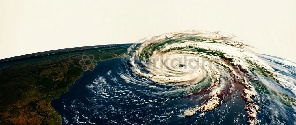
Cyclone Arnab developed rapidly over the Bay of Bengal in late October 2026. The storm tests national response systems under the India Meteorological Department. While early evacuation protocols succeed, coastal embankments and rural power distribution networks face severe strain.
Abnormal ocean warming drives rapid intensification across the North Indian Ocean. Storm shelters save lives during landfall. Securing vulnerable coastal livelihoods, however, requires engineering resilience and ecological bioshields aligned with global risk frameworks.
Why Cyclone Arnab Is in the News
The India Meteorological Department designated a deep depression over the east-central Bay of Bengal as Cyclonic Storm Arnab on the morning of 26 October 2026. According to the IMD National Bulletin No. 8 on Cyclonic Storm Arnab, the system lay centred near latitude 15.4°N and longitude 88.9°E over the east-central and adjoining southeast Bay of Bengal.
As of October 2026, the storm triggered inter-agency coordination between national forecasters and state emergency authorities under the Disaster Management Act, 2005. Key storm parameters established by monitoring agencies include:
- Nomenclature: The name 'Arnab' was contributed by Bangladesh, signifying 'ocean' or 'sea' in Bengali, drawn from the 169-name roster adopted in April 2020 by the WMO/ESCAP Panel on Tropical Cyclones.
- Classification: Under the IMD classification scale, a Very Severe Cyclonic Storm generates maximum sustained 3-minute surface wind speeds of 64 to 89 knots (118 to 166 kmph).
- Governance Mandate: Operations focus on executing statutory response protocols under the Disaster Management Act, 2005.
Tracking the Path: Steering Winds, Trajectory, and Landfall Projections
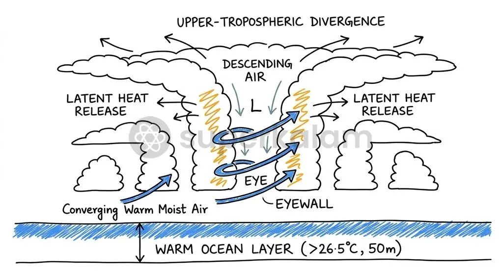
Tropical cyclone trajectories across the Bay of Bengal depend on environmental steering winds. These currents circulate between 850 hPa and 200 hPa along the subtropical anticyclone ridge within the mid-to-upper troposphere. Hydrodynamic drag dictates whether a storm advances west towards peninsular India or curves north-east.
Cyclogenesis requires strict physical conditions. Thermodynamic development demands sea surface temperatures of at least 26.5°C across an ocean mixed layer extending 50 metres deep to release latent heat. A non-zero Coriolis force is equally mandatory, confining cyclogenesis to latitudes higher than 5 degrees from the Equator.
| Physical Parameter | Critical Scientific Threshold | Atmospheric / Oceanographic Function |
|---|---|---|
| Sea Surface Temperature (SST) | $\ge$ 26.5°C (to 50 m depth) | Supplies continuous latent heat flux powering the central convective engine. |
| Coriolis Force | Latitudes > 5° North or South | Initiates cyclonic vorticity and maintains low-level gradient wind balance. |
| Environmental Steering Layer | 850 hPa to 200 hPa tropospheric flow | Establishes the directional track vector via subtropical anticyclonic ridges. |
| Vertical Wind Shear | Weak to moderate (< 10–12 knots) | Prevents the vertical tilting of the nascent storm core, enabling symmetrical growth. |
According to the IMD Special Tropical Weather Outlook and Cyclone Warning issued on 26 October 2026, Cyclone Arnab is forecast to track west-northwestwards and make landfall along the Andhra Pradesh and Yanam coasts between Bapatla and Visakhapatnam during the forenoon of 28 October 2026 as a Very Severe Cyclonic Storm. Coastal bulletins from the IMD Cyclone Warning Centre in Visakhapatnam indicate the system is forecast to generate sustained wind speeds of 115 to 125 kmph, gusting up to 140 kmph, as it traverses the coastline.
Discuss with Superkalam
What are the specific threshold values for Sea Surface Temperature and Coriolis latitude required to trigger cyclogenesis?
Ask NowRapid Intensification: Why Modern Cyclones Defy Traditional Timelines
Rapid intensification compresses civil preparation timelines before coastal landfall. Defined by the World Meteorological Organization and the IMD, Rapid Intensification (RI) occurs when sustained wind speeds increase by at least 30 knots (15.4 m/s or 55 kmph) within 24 hours. This rapid shift narrows evacuation windows for vulnerable districts.
Oceanographic evaluations by the Indian National Centre for Ocean Information Services (INCOIS) documented two primary catalysts during late October 2026:
- Elevated Sea Temperatures: Surface readings reached 29–31°C across the central Bay of Bengal, generating an exceptional thermal energy reservoir.
- Weak Vertical Shear: Wind shear remained between 5 and 10 knots, enabling symmetrical core development.
Marine heatwaves accelerate ocean evaporation rates. As a result, tropical disturbances build compact inner cores quickly and surpass standard intensity forecasts.
Discuss with Superkalam
How does Impact-Based Forecasting differ fundamentally from traditional cyclone weather bulletins in operational disaster management?
Ask NowInside IMD's Warning System: From Pre-Cyclone Watch to Impact Forecasts
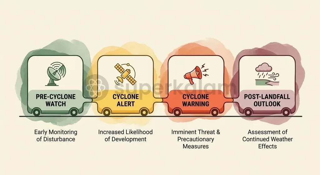
The India Meteorological Department administers a four-stage cyclone warning protocol. This operational sequence alerts disaster managers up to 72 hours before landfall, initiating safety measures before gale-force winds strike.
- Stage 1 (Pre-Cyclone Watch): Issued at least 72 hours in advance, alerting central and state administrative authorities regarding potential development.
- Stage 2 (Cyclone Alert): Dispatched at least 48 hours in advance using yellow-coded messaging to specify expected coastal belts at risk.
- Stage 3 (Cyclone Warning): Issued at least 24 hours prior to adverse coastal weather in orange or red formatting, fixing landfall coordinates and gale wind envelopes.
- Stage 4 (Post-Landfall Outlook): Released at least 12 hours before landfall to project inland storm decay, gale-force penetration, and interior flooding.
Coastal surveillance relies on S-band Doppler Weather Radars covering 400 to 500 kilometres. Radars monitor spiral rainbands, eyewall structure, and wind velocity. Further offshore, meteorologists apply the Dvorak technique across cloud patterns on INSAT-3D/3DR imagery to infer central pressure and wind speeds.
On 12 October 2026, the IMD dedicated to the nation an interactive WebGIS platform called the Cyclone Warning and Marine Weather Services Decision Support System (DSS). This system operationalises Impact-Based Forecasting (IBF). Instead of reporting general meteorological numbers alone, advisories overlay hazard maps onto local infrastructure data through the Common Alerting Protocol to flag vulnerable bridges and power lines.
Discuss with Superkalam
Break down why modern marine heatwaves and low vertical wind shear compress administrative evacuation timelines along the eastern coast.
Ask NowTesting Coastal Defenses: Evacuation Gains Versus Structural Fragility
Coastal disaster authorities execute non-structural evacuations efficiently, yet physical infrastructure remains vulnerable to storm surges. Following alerts for Cyclone Arnab on 25–26 October 2026, Andhra Pradesh and Odisha activated control rooms, deployed response battalions, and relocated coastal populations, as reported across regional disaster updates.
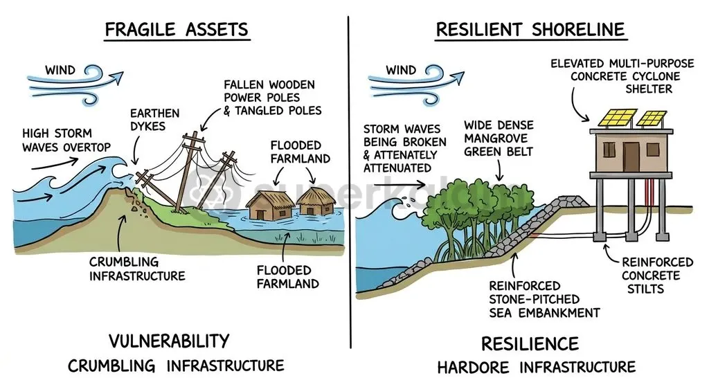
Physical defences still face structural limitations. Assessments from the National Disaster Management Authority (NDMA) reveal that earthen embankments frequently breach during storm surges, triggering severe saline water intrusion into farm lands. In addition, overhead power distribution grids routinely collapse under sustained cyclonic winds.
| Defence Dimension | Operational Strengths (Current Setup) | Structural Vulnerabilities (Deficit Areas) |
|---|---|---|
| Evacuation & Sheltering | Rapid early evacuation; over 790 Multi-Purpose Cyclone Shelters built under NCRMP. | Overcrowding during peak events; poor sanitation access and limited livestock accommodations. |
| Power Infrastructure | Installation of over 1,380 km of underground electrical cabling in vulnerable towns. | Vast rural peripheries remain tied to vulnerable overhead wires and fragile distribution poles. |
| Coastal Protection Works | Concrete sea walls and revetments guarding major urban harbours and designated ports. | Extensive earthen dykes remain prone to saline overtopping and destructive scouring. |
To address structural deficits, the Central Government executed the National Cyclone Risk Mitigation Project (NCRMP) with World Bank loan assistance. Phase I ended in December 2018 with an expenditure of ₹2,524.84 crore in Andhra Pradesh and Odisha. Phase II concluded in March 2023 with an expenditure of ₹1,806.84 crore across six additional maritime states. The scheme funded over 790 cyclone shelters and 1,380 kilometres of underground power cabling along vulnerable coastal stretches.
Way Forward: Building Resilient Shorelines Beyond Temporary Shelters
Disaster reduction frameworks prioritise long-term structural hardening and nature-based bioshields over temporary shelters. Evacuations protect human lives during landfall, but long-term community resilience requires defending local agricultural and economic assets.
Nature-based solutions offer significant physical protection. Studies show that mangrove bioshields attenuate storm surges by up to 66% across a 100-metre forest belt. Root structures, including pneumatophores and prop roots, create frictional drag that dissipates kinetic wave energy.
Under the MISHTI scheme launched in 2023, India plans to restore approximately 540 square kilometres of mangrove forests across 11 coastal States and 2 Union Territories through 2028. State programmes show active implementation. Andhra Pradesh restored 2,047.70 hectares of estuarine mangroves during 2025–26 using the fish-bone channel design to facilitate tidal flushing, as reported in coastal forestry reviews.
Long-term governance aligns with the Sendai Framework for Disaster Risk Reduction (2015–2030):
- Target G: Substantially increasing access to multi-hazard early warning systems and risk assessments by 2030.
- Priority 3: Investing in disaster risk reduction for resilience via underground power networks and resilient buildings.
- Priority 4: Enhancing disaster preparedness to "Build Back Better" during recovery and reconstruction.
Sustainable protection requires enforcing the Coastal Regulation Zone (CRZ) Notification, 2019, while replacing fragile earthen dykes with geo-textile reinforced embankments. Combining hard engineering with coastal mangrove bioshields safeguards coastal populations against intensifying storms.
Discuss with Superkalam
Given the persistent breaches of coastal earthen dykes and overhead grid failures, evaluate whether financial outlays under NCRMP have sufficiently balanced life-saving vs asset-protecting infrastructure.
Ask NowKey Takeaways
- Cyclonic Storm Arnab formed over the east-central Bay of Bengal on 26 October 2026, bearing a name contributed by Bangladesh from the official WMO/ESCAP panel roster.
- Tropical cyclogenesis demands sea surface temperatures of at least 26.5°C over a 50-metre ocean layer alongside sufficient Coriolis force, with cyclone tracks governed by mid-to-upper tropospheric steering winds.
- Rapid intensification describes an increase in sustained winds of at least 30 knots within 24 hours, accelerated in the Bay of Bengal by anomalous sea surface temperatures reaching 29–31°C.
- The IMD manages storm threats through a 4-stage protocol (Pre-Cyclone Watch, Cyclone Alert, Cyclone Warning, Post-Landfall Outlook) supported by Doppler radars, Dvorak analysis, and the WebGIS Decision Support System.
- India's coastal defense requires shifting from non-structural evacuations to structural hardening under the NCRMP and ecological solutions like mangrove bioshields funded through the MISHTI initiative.
Mains Question
"While India's early warning architecture and non-structural evacuation measures have drastically curtailed human mortality during tropical cyclones, the resilience of physical infrastructure remains deeply compromised." Evaluate the effectiveness of interventions under the National Cyclone Risk Mitigation Project (NCRMP) in mitigating coastal vulnerability. (15 Marks)
Evaluate NowMains Question
Impact-Based Forecasting (IBF) marks a paradigm shift from conventional meteorological advisories to localized risk governance. Elucidate in the context of recent coastal disaster surveillance systems introduced by the India Meteorological Department. (10 Marks)
Evaluate NowPractice MCQs
QUESTION 1
With reference to cyclogenesis and the dynamics of tropical storms as monitored by the India Meteorological Department (IMD), consider the following statements:
- A sea surface temperature of at least 26.5°C across an ocean mixed layer reaching up to 50 metres depth is necessary to provide latent heat flux.
- Tropical cyclogenesis is inhibited within 5 degrees latitude north or south of the Equator due to an insufficient Coriolis force.
- The directional track vector of a tropical cyclone is predominantly steered by atmospheric currents circulating between 850 hPa and 200 hPa along subtropical anticyclone ridges. Which of the statements given above are correct?
QUESTION 2
Consider the following statements regarding the standard cyclone warning protocols formulated by the India Meteorological Department (IMD):
- Stage 1 (Pre-Cyclone Watch) is issued at least 72 hours in advance to alert central and state administrative authorities.
- Stage 2 (Cyclone Alert) uses yellow-coded messaging issued at least 48 hours in advance to specify coastal belts at risk.
- Stage 3 (Cyclone Warning) is issued at least 24 hours prior to landfall, utilizing orange or red formatting to fix landfall coordinates. Which of the statements given above is/are correct?
QUESTION 3
According to the World Meteorological Organization (WMO) and the India Meteorological Department (IMD), which of the following criteria defines the phenomenon of 'Rapid Intensification' (RI) in a tropical cyclone?
QUESTION 4
With reference to cyclone classification and monitoring technologies used in India, consider the following statements:
- A 'Very Severe Cyclonic Storm' under the IMD scale is characterized by maximum sustained 3-minute surface wind speeds of 64 to 89 knots.
- Coastal S-band Doppler Weather Radars track cyclonic systems with an operational surveillance range extending up to 400 to 500 kilometres.
- The Dvorak technique is an observational tool applied to satellite imagery from INSAT-3D/3DR to estimate storm intensity and central pressure. Which of the statements given above are correct?
QUESTION 5
Regarding coastal disaster mitigation measures undertaken through the National Cyclone Risk Mitigation Project (NCRMP), consider the following statements:
- The project has been executed by the Central Government with financial loan assistance from the Asian Development Bank (ADB).
- Phase I and Phase II of the project together completed over 790 Multi-Purpose Cyclone Shelters and more than 1,380 kilometres of underground electrical cabling. Which of the statements given above is/are correct?