Cyclone Akvan: Why the Bay of Bengal Breeds Severe Post-Monsoon Storms
Explore how trapped freshwater and low wind shear transform post-monsoon depressions into destructive storms, challenging coastal disaster preparedness.
Nov, 2026
•9 min read
Overview
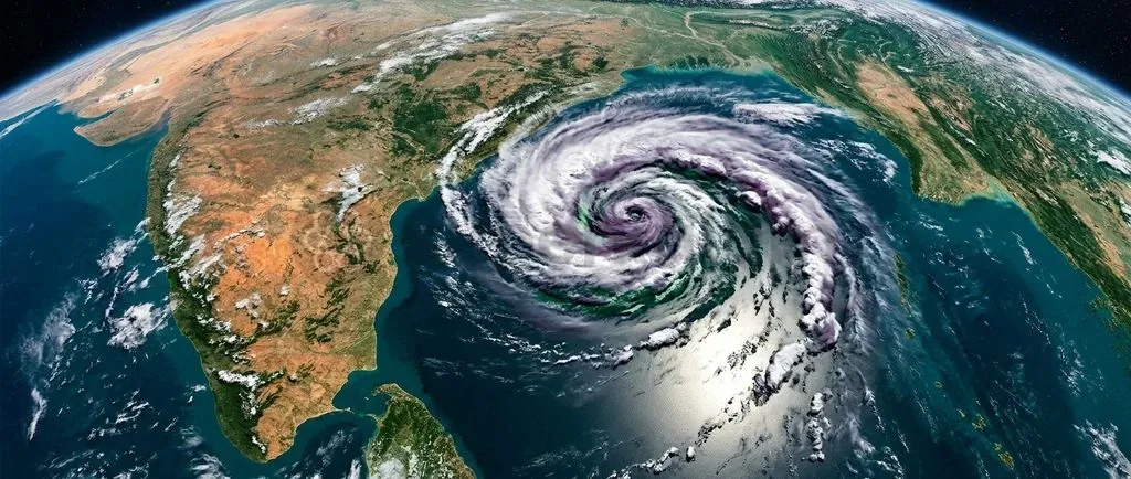
Cyclone Akvan illustrates how post-monsoon thermodynamics in the Bay of Bengal transform seasonal tropical depressions into severe storms capable of rapid intensification. The system builds on the interaction between retreating monsoon winds, high upper-ocean heat reservoirs, and intense salinity stratification driven by continental runoff.
As the Inter-Tropical Convergence Zone migrates south across October and November, falling vertical wind shear meets surface temperatures above 28°C. This combination creates an exceptionally fertile corridor for cyclogenesis. The resulting barrier layer blocks the normal cold-water upwelling that typically cools sea surfaces under storms, keeping deep thermal stores insulated.
Why Cyclone Akvan Is in the News: Track, Intensity, and Formation
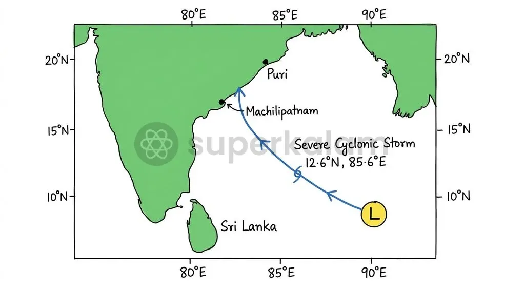
Cyclone Akvan intensified over the central Bay of Bengal on November 18, 2026, marking another severe post-monsoon storm in the North Indian Ocean. According to the India Meteorological Department and the Regional Specialised Meteorological Centre New Delhi, the system developed from a low-pressure disturbance over the southeast and adjoining southwest Bay of Bengal. It organised into a deep depression before strengthening into Cyclonic Storm Akvan on November 16, 2026.
Observations at 0530 hours IST on November 18 placed the storm's centre near Latitude 12.7°N and Longitude 85.5°E. That put it roughly 580 km east of Chennai and 610 km southeast of Machilipatnam.
- Current Classification: It graduated into a Severe Cyclonic Storm over warm equatorial waters, sustaining maximum surface winds between 88 and 117 km/h.
- Projected Track: As of November 2026, meteorological advisories project the storm to track north-northwestwards.
- Landfall Window: Forecasters anticipate landfall along the Andhra Pradesh and Yanam coasts between Nellore and Visakhapatnam around noon on November 20, as a severe cyclonic storm with maximum sustained winds of 100-110 km/h gusting to 120 km/h.
Iran contributed the name 'Akvan' through the World Meteorological Organization and United Nations Economic and Social Commission for Asia and the Pacific (WMO/ESCAP) Panel on Tropical Cyclones. The moniker stems from Akvan Div, a mythical entity in Ferdowsi's Persian epic, the Shahnameh.
Under the naming framework maintained by the Ministry of Earth Sciences and WMO/ESCAP, 13 northern Indian Ocean member nations contribute 13 nominations each. This yields a 169-name sequential roster that prevents operational confusion during overlapping storms, with retired cyclone names never reused in subsequent cycles.
Discuss with Superkalam
What threshold of sustained wind speed increase over a 24-hour period defines Rapid Intensification according to the IMD?
Ask NowThe Post-Monsoon Trap: Why October and November Breed Stronger Cyclones
Post-monsoon atmospheric dynamics in the Bay of Bengal reflect the southward retreat of the Inter-Tropical Convergence Zone and retreating southwest monsoonal winds. Climatological assessments by the India Meteorological Department show the basin displays a distinct bimodal cyclone frequency. It registers operational peaks during the pre-monsoon (April to June) and post-monsoon (October to December) transition windows.
The post-monsoon phase is historically far more hazardous. It generates nearly four times more cyclonic systems than the neighbouring Arabian Sea basin.
The retreat of monsoonal south-westerlies brings low vertical wind shear, which typically falls below 10 to 15 knots across the central basin. Wind shear measures the difference in wind velocity and direction across vertical tropospheric layers. Strong shear tears developing cloud columns apart and tilts the storm's core. By contrast, light shear between October and December lets warm moist air rise unimpeded, allowing cloud towers to align vertically around a single axis.
Thermodynamic factors speed up this cyclonic development:
- Sea Surface Temperatures (SSTs): Sustained cyclogenesis demands SSTs exceeding 28°C to release the latent heat of condensation powering the convective engine.
- Ocean Thermal Reserves: The basin must hold an elevated Tropical Cyclone Heat Potential (TCHP) of at least 40 to 50 kJ/cm². TCHP measures heat down to the 26°C isotherm, ensuring surface churning does not quickly deplete the storm's fuel.
The India Meteorological Department monitors and categorises these maturing disturbances using a standardised operational wind scale:
- Cyclonic Storm: Maximum sustained surface wind speeds of 62 to 87 km/h.
- Severe Cyclonic Storm: Maximum sustained surface wind speeds of 88 to 117 km/h.
- Very Severe Cyclonic Storm: Maximum sustained surface wind speeds of 118 to 165 km/h.
- Extremely Severe Cyclonic Storm: Maximum sustained surface wind speeds of 166 to 221 km/h.
- Super Cyclonic Storm: Sustained surface wind speeds of 222 km/h and above.
Discuss with Superkalam
Explain how continental river runoff from the Ganga-Brahmaputra-Meghna system alters the vertical thermal structure of the Bay of Bengal.
Ask NowThe Fresh-Water Blanket: How River Discharge Superheats the Upper Ocean
The Ganga-Brahmaputra-Meghna river system reshapes the northern Bay of Bengal's upper structure by discharging massive freshwater volumes annually. Research coordinated through the European Space Agency shows this monsoonal drainage injects between 1,000 and 1,300 cubic kilometres of continental runoff into the semi-enclosed basin. This buoyant, low-density layer floats directly over the denser, more saline marine water below.
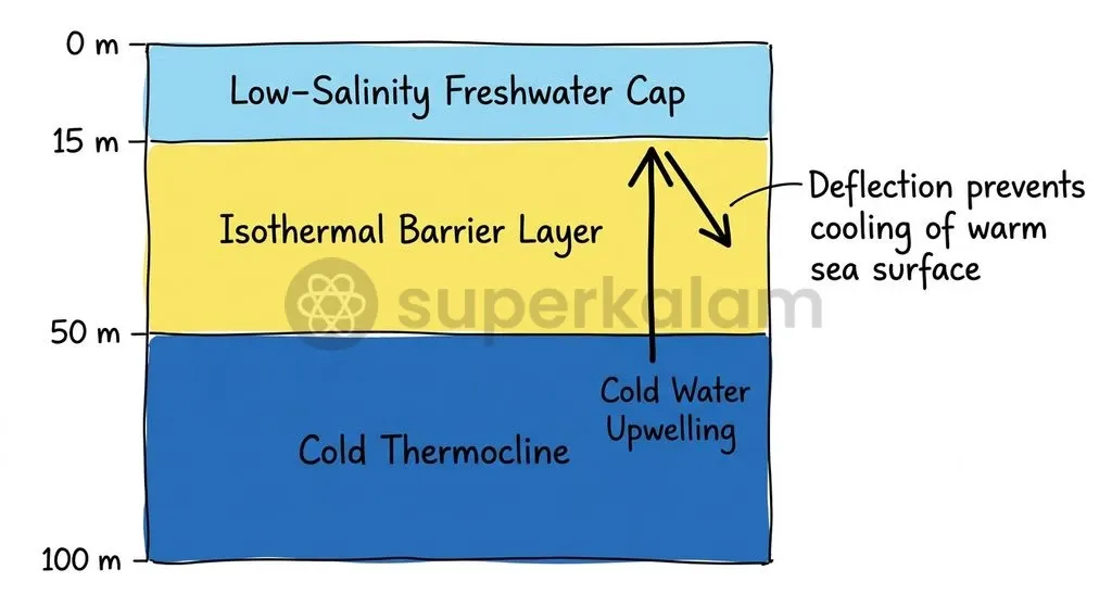
That density contrast triggers sharp salinity stratification, forming a shallow halocline between 5 and 20 metres below the sea surface. In typical open-ocean waters, temperature controls upper density profiles. In the Bay of Bengal, salinity differences govern stratification instead, disconnecting the surface mixed layer from the deeper thermal system.
| Vertical Ocean Layer | Depth Range | Physical Characteristics |
|---|---|---|
| Surface Mixed Layer | 0 to ~15 m | Low salinity, SST > 28°C, direct atmospheric contact |
| Isothermal Barrier Layer | ~15 to ~50 m | Trapped warm water, suppresses mechanical mixing |
| Deep Ocean Layer | Below ~50 m | High salinity, cold waters separated by the thermocline |
This dislocation creates an isothermal barrier layer between the base of the shallow mixed layer and the cold thermocline below. Under standard ocean conditions, cyclonic gale winds churn up cold deep water to produce a protective "cold wake" that limits storm intensity. In the Bay of Bengal, the barrier layer is a physical shock absorber. The salinity gradient resists mechanical mixing, preventing cooler deep water from surfacing and leaving the warm upper ocean free to feed the cyclone core uninterrupted.
Discuss with Superkalam
Compare the hydrographic and atmospheric factors that make the post-monsoon Bay of Bengal four times more cyclone-prone than the Arabian Sea.
Ask NowBay of Bengal vs. Arabian Sea: Contrasting the Two Ocean Basins
The Bay of Bengal and the Arabian Sea display sharply contrasting hydrographic characteristics that dictate their respective vulnerability to severe cyclonic storms. Both bodies lie within the tropical northern Indian Ocean, yet geographical differences in coastal geometry, surface evaporation, and monsoonal freshwater inflow yield distinct oceanic environments.
| Climatological Dimension | Bay of Bengal Basin | Arabian Sea Basin |
|---|---|---|
| Annual Freshwater Discharge | High (1,000–1,300 km³ from the Ganga-Brahmaputra-Meghna system) | Modest (Limited continental runoff, high net surface evaporation) |
| Upper-Ocean Stratification | Intense halocline and prominent isothermal barrier layer | Weak salinity stratification, deeper convective mixing |
| Cold-Water Upwelling Response | Inhibited by buoyant fresh-water cap, retaining high SSTs | Readily induced under cyclonic winds, triggering self-limiting SST cooling |
| Post-Monsoon Wind Shear | Consistently low (< 10–15 knots) post-southwest monsoon withdrawal | Variable, often interrupted by lingering mid-tropospheric dry air intrusions |
| Cyclogenesis Frequency Ratio | Generates roughly 4 times more post-monsoon systems historically | Historically lower storm generation, though recording shifting modern baselines |
Regional geography reinforces these ocean dynamics. The Bay of Bengal forms a narrow, funnel-shaped basin bordered by land on three sides, directing storms straight into crowded coastal lowlands.
Atmospheric remnants from the western Pacific and South China Sea also cross the Malayan Peninsula into the Andaman Sea, where high heat helps them regenerate into active circulations. The Arabian Sea, meanwhile, opens broadly to the south and takes in dry desert air from the northwest, which historically curbed prolonged storm development.
Rapid Intensification: Why Modern Storms Defy Early Forecasts
The India Meteorological Department records rapid intensification when a cyclone increases its maximum sustained surface wind speeds by at least 30 knots (55 km/h) within a 24-hour window. Converted to metric units, this jump equates to roughly 15.4 m/s in maximum surface winds across a single day. This rapid surge narrows warning windows, leaving disaster agencies with minimal time to coordinate coastal evacuations.
Tracking these sudden spikes relies on coordinated space-based and ground radar instruments:
- Spaceborne Scatterometry: The National Remote Sensing Centre and ISRO deploy ocean scatterometers, notably on EOS-06 (Oceansat-3), to measure surface wind-stress vectors over open water. Scatterometers see through heavy clouds to gauge sea surface roughness, mapping circulations before an eye forms.
- Coastal Doppler Radar: The India Meteorological Department operates an integrated Doppler Weather Radar (DWR) network. Coastal radar stations on S-band and C-band frequencies—including Chennai, Machilipatnam, Visakhapatnam, Gopalpur, and Paradip—provide continuous tracking across a 400-kilometre operational radius.
These coastal radars capture internal rainfall rates, eye-wall contraction, and radial velocity shifts. Forecasters use these cues to spot signs of rapid intensification as systems near coastal areas.
Discuss with Superkalam
Given the narrowing warning windows caused by Rapid Intensification, evaluate the operational limitations of relying primarily on coastal Doppler Weather Radars with a 400-km range.
Ask NowProtecting the Coastline: From Early Warning to Climate-Resilient Infrastructure
The National Disaster Management Authority aligns coastal defence with the Sendai Framework for Disaster Risk Reduction 2015–2030. India's disaster management plan integrates Sendai's core pillars: understanding risk, strengthening risk governance, investing in resilience, and adopting Build Back Better practices. This approach shifts disaster management from post-calamity relief to proactive risk reduction.
Key interventions combine engineered shelters, digital early warning, and coastal ecology:
- Engineered Multi-Purpose Shelters: Under the World Bank-assisted National Cyclone Risk Mitigation Project (NCRMP), state authorities have built over 3,000 Multi-Purpose Cyclone Shelters (MPCS) engineered against severe wind loads and tidal surges.
- Automated Early Warnings: Coastal Early Warning Dissemination Systems (EWDS) use last-mile sirens and digital broadcasts to alert vulnerable villages directly.
- Mangrove Bio-Shields: The Union Budget 2023–24 introduced the MISHTI programme (Mangrove Initiative for Shoreline Habitats & Tangible Incomes). It tasks the Ministry of Environment, Forest and Climate Change with restoring roughly 540 square kilometres of mangroves across 9 coastal States and 4 Union Territories between 2023 and 2028.
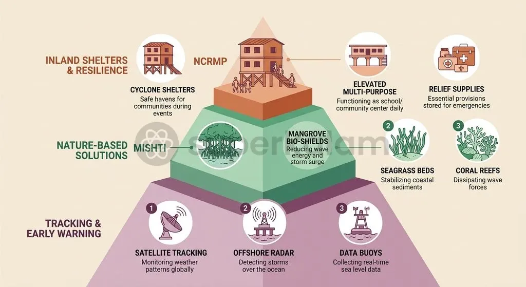
Mangrove ecosystems form living breakwaters, blunting storm wave power and buffering low-lying coastlines.
Adapting to shifting climate conditions requires matching this green and grey infrastructure with finer scientific tools. As sea temperatures and ocean heat rise across the northern Indian Ocean, rapid intensification is becoming standard operational reality. Protecting vulnerable communities requires expanding ocean sensor arrays, upgrading numerical weather models for micro-salinity stratification, and reinforcing coastal defences.
Key Takeaways
- Genesis Dynamics: Cyclone Akvan originated in the southern Bay of Bengal before strengthening into a Severe Cyclonic Storm on November 18, 2026, driven by high sea surface temperatures and low vertical wind shear.
- Thermodynamic Thresholds: Post-monsoon cyclogenesis requires sea surface temperatures exceeding 28°C alongside a Tropical Cyclone Heat Potential of at least 40 to 50 kJ/cm² to support deep convection.
- The Barrier Layer Effect: Massive annual freshwater runoff from the Ganga-Brahmaputra-Meghna system creates a shallow halocline (5–20 m) that traps thermal energy and suppresses cold-water upwelling.
- Rapid Intensification Benchmark: The India Meteorological Department defines rapid intensification as an increase in maximum sustained surface wind speeds of at least 30 knots (55 km/h) within a 24-hour window.
- Disaster Risk Architecture: India's coastal resilience strategy integrates the four priorities of the Sendai Framework through over 3,000 cyclone shelters under the NCRMP and 540 sq km of targeted mangrove restoration under the MISHTI scheme.
Mains Question
"The unique confluence of retreating monsoonal wind dynamics and salinity stratification makes the Bay of Bengal an exceptionally potent breeding ground for post-monsoon cyclogenesis." Elucidate. (10 Marks)
Evaluate NowMains Question
Assessing the phenomenon of Rapid Intensification (RI) in tropical cyclones over the North Indian Ocean, evaluate the role of space-based observational platforms and Doppler Weather Radar networks in mitigating coastal vulnerability. (15 Marks)
Evaluate NowPractice MCQs
QUESTION 1
With reference to cyclogenesis and ocean thermodynamics in the Bay of Bengal, consider the following statements:
- Tropical Cyclone Heat Potential (TCHP) is measured down to the 26°C isotherm to quantify thermal energy available for convective systems.
- The massive discharge from the Ganga-Brahmaputra-Meghna system establishes a deep mixed layer governed primarily by temperature gradients.
- The formation of an isothermal barrier layer prevents the mechanical upwelling of colder subsurface waters under cyclonic gale winds. Which of the statements given above are correct?
QUESTION 2
Consider the following statements regarding tropical cyclone classification and monitoring by the India Meteorological Department (IMD):
- A tropical disturbance is classified as a Severe Cyclonic Storm when sustained maximum surface wind speeds reach 88 to 117 km/h.
- Rapid intensification is defined as an increase in maximum sustained surface wind speeds of at least 30 knots within a 24-hour period.
- The operational coastal Doppler Weather Radar network tracks developing storms up to a radius of 1,000 kilometres from the shore. Which of the statements given above is/are correct?
QUESTION 3
With reference to the comparative oceanographic and atmospheric dynamics between the Bay of Bengal and the Arabian Sea, consider the following statements:
- The Bay of Bengal registers a distinct bimodal cyclone distribution peaking during the pre-monsoon and post-monsoon transition periods.
- Post-monsoon vertical wind shear over the central Bay of Bengal typically falls below 10 to 15 knots, aiding vertical alignment of convective cloud towers.
- Historically, the Arabian Sea produces approximately four times more post-monsoon cyclonic systems than the Bay of Bengal due to intense surface evaporation. Which of the statements given above is/are correct?
QUESTION 4
Which of the following oceanographic mechanisms best explains why the Bay of Bengal upper ocean resists self-induced surface cooling during severe cyclonic events?
QUESTION 5
With reference to the naming of tropical cyclones in the North Indian Ocean basin, consider the following statements:
- The naming roster is maintained by the WMO/ESCAP Panel on Tropical Cyclones comprising 13 member countries.
- Each member nation contributes 13 names, establishing a sequential roster of 169 names.
- Once a tropical cyclone name is officially utilized, it is retired and cannot be reused in subsequent cycles. Which of the statements given above are correct?