Coastal Erosion in India: Shoreline Assessment & East Coast Risks
With over a third of India's coastline actively eroding, understanding regional sediment dynamics and CRZ policies is essential for coastal governance in UPSC.
Aug, 2026
•8 min read
Overview
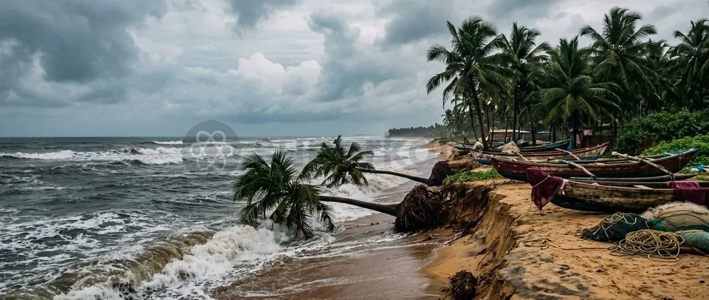
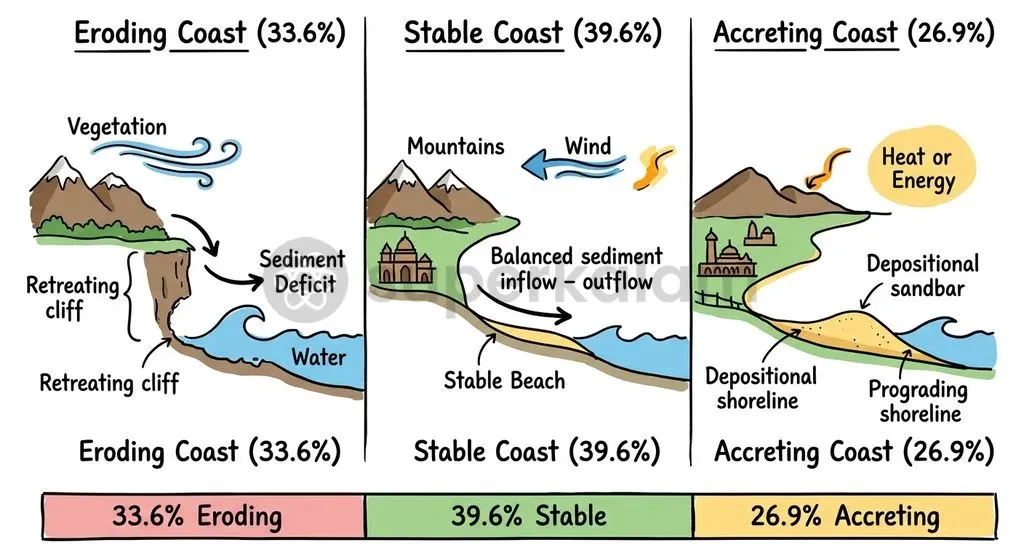
India's coastline is retreating fast. National Centre for Coastal Research assessments reveal that 33.6% of mainland India's coastline is actively eroding. Intense cyclonic surges, disrupted littoral drift, and deltaic sediment deprivation place a heavy toll on the eastern seaboard. In contrast, accretion accounts for 26.9% of the shoreline while 39.6% remains stable.
Vulnerability is concentrated along the east coast. West Bengal and the Union Territory of Puducherry now record erosion across more than half their coastal frontage. Mapping these shifts directs spatial planning, disaster mitigation, and climate-resilient coastal infrastructure under the Coastal Regulation Zone framework.
Why in the News: The Updated Shoreline Classification
Recent parliamentary disclosures from the Ministry of Environment, Forest and Climate Change present updated shoreline data across maritime states. As of February 2025, official records confirm that eastern littoral states face severe shoreline retreat compared to western coasts.
State-level findings highlight sharp regional contrasts:
- West Bengal: Most vulnerable nationwide, with 60.5% (323.07 km) of its 534.35 km coastline undergoing active retreat.
- Puducherry: Experiences 56.2% shoreline erosion along the Coromandel Coast.
- Tamil Nadu: Records active erosion along 42.7% of its 991.47 km shoreline.
- Odisha: The primary maritime outlier where deposition dominates, logging 51.0% (280.02 km) accretion against 25.6% erosion.
- Andhra Pradesh: Documents a 49.6% accreting coast across 1,027.58 km of shoreline, alongside 28.7% eroding sections.
What Is the National Coastal Shoreline Assessment?
The National Centre for Coastal Research, an attached office of the Ministry of Earth Sciences, oversees the assessment across mainland India. Operating from Chennai, this nodal body monitors shoreline dynamics, charts vulnerability, and designs site-specific Shoreline Management Plans (SMPs).
Three specialized scientific bodies drive monitoring and regulation:
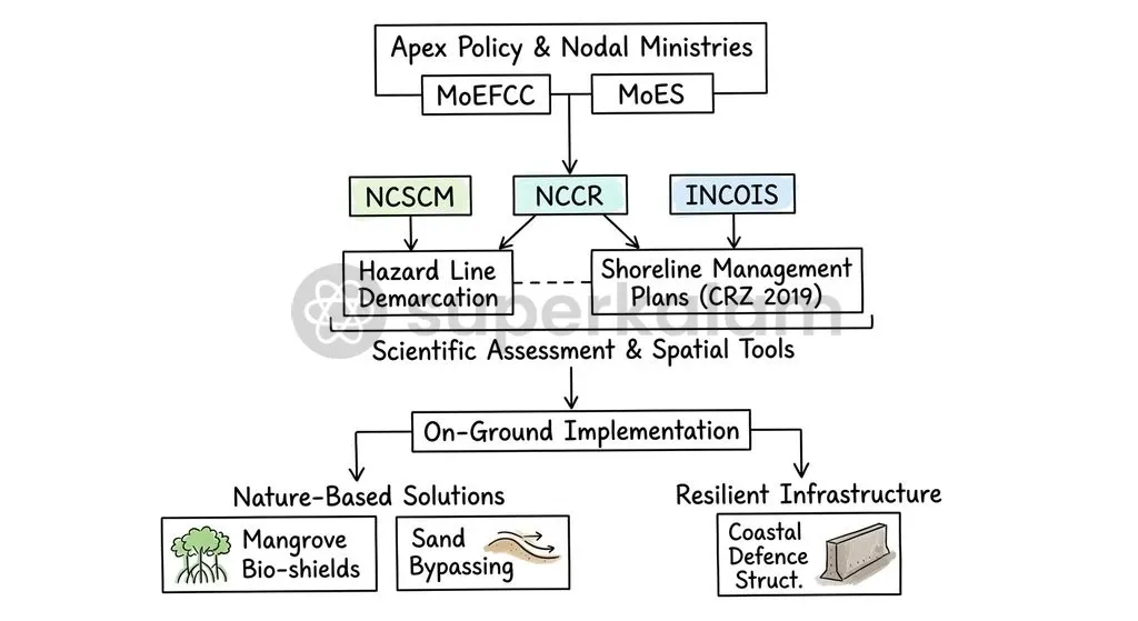
- National Centre for Coastal Research (NCCR): Monitors baseline shoreline change, models sediment transport, and provides mitigation frameworks to coastal states.
- National Centre for Sustainable Coastal Management (NCSCM): Operates under the Ministry of Environment, Forest and Climate Change to support coastal zoning, map Ecologically Sensitive Areas, and demarcate the composite Hazard Line.
- Indian National Centre for Ocean Information Services (INCOIS): Maps multi-hazard vulnerability by issuing a 1:100,000 scale Coastal Vulnerability Index (CVI) Atlas.
The index developed by INCOIS tracks seven physical parameters. These include shoreline change rate, sea-level change rate, coastal elevation, coastal slope, geomorphology, significant wave height, and regional tidal range.
How Are Shorelines Classified: Stable, Accreting, and Eroding Coasts
NCCR maps coastal stretches at 1:25,000 scale to determine long-term morphological change. Using multi-temporal satellite imagery alongside the Digital Shoreline Analysis System (DSAS), scientists quantify net shoreline shifts over multi-decadal baselines. Coasts are categorized into High, Moderate, and Low erosion, stable, or accreting zones.
India's 6,907.18 km mainland coastline breaks down into three baseline categories:
| Coastal Classification Status | Mainland Shoreline Coverage (km) | Proportion of Total Mainland Coast (%) | Primary Dynamic Characteristics |
|---|---|---|---|
| Eroding Coast | ~2,320.81 km | 33.6% | Net landward retreat; sediment loss exceeds natural replenishment; beach profile degradation. |
| Accreting Coast | ~1,858.03 km | 26.9% | Net seaward advancement; sediment deposition exceeds wave-driven removal; formation of spits and shoals. |
| Stable Coast | ~2,735.24 km | 39.6% | Dynamic equilibrium; sediment inputs roughly match littoral transport and wave removal. |
Eastern states bear an uneven burden. West Bengal leads with 60.5% coastal retreat, triggered by powerful hydrodynamic energy in the estuarine delta.
Discuss with Superkalam
Which specialized scientific institution under the Ministry of Earth Sciences maps shoreline change using the Digital Shoreline Analysis System (DSAS)?
Ask NowWhy India’s East Coast Faces Higher Erosion Pressures
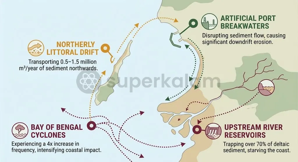
Severe meteorological hazards, high hydrodynamic energy, and starving fluvial sediment supplies drive eastern coastal retreat. The regional oceanography of the Bay of Bengal combines with upstream hydrological barriers to generate chronic sediment deficits.
Four drivers govern this vulnerability:
- Disproportionate Cyclonic Frequency: The Bay of Bengal generates cyclonic storms at roughly four times the frequency of the Arabian Sea. Eastern barrier beaches and mudflats endure repeated, severe wave battering.
- High-Energy Littoral Drift: A strong northerly drift operates along the East Coast during the Southwest Monsoon. It moves an estimated 0.5 to 1.5 million cubic metres of sand along the shoreline each year.
- Hard Engineering Interventions: Breakwaters and training walls at ports like Visakhapatnam, Chennai, and Paradip block this sediment flow. These structures trigger heavy updrift sediment accumulation alongside severe downdrift erosion.
- Upstream Fluvial Sediment Deprivation: Dams and reservoirs across the Godavari, Krishna, Mahanadi, and Cauvery have curtailed deltaic sediment discharge by over 70% in specific basins. This deprives delta fronts of vital replenishment.
East Coast vs West Coast: Key Geomorphological Differences
Geological origin separates the broad shelf of the East Coast from the steep, faulted margin along the West Coast. These distinct structures dictate wave interaction and erosion susceptibility.
| Geomorphological Parameter | India's East Coast | India's West Coast |
|---|---|---|
| Tectonic & Coastal Nature | Primarily an emergent coastline, characterised by broad alluvial plains and extensive prograding deltas. | Primarily a submergent and faulted coastline, featuring drowned river valleys, estuaries, and steep Western Ghats scarps. |
| Continental Shelf Width | Broad and shallow continental shelf, dampening deep-water waves but spreading storm surge inundation over wide coastal zones. | Narrow, steep continental shelf with abrupt drop-offs, allowing deep-water wave energy closer inshore. |
| Fluvial Sediment Regimes | Dominated by large, mature river systems (Mahanadi, Godavari, Krishna, Cauvery) historically depositing massive sediment loads. | Dominated by short, swift, seasonal rivers that discharge directly into estuaries with minimal delta formation. |
| Littoral Transport Rates | Pronounced, uninterrupted northerly littoral drift of 0.5 to 1.5 million m³/year, highly sensitive to artificial interruption. | Moderate and variable littoral drift, frequently interrupted naturally by prominent rocky headlands and promontories. |
| Primary Erosion Hotspots | Sundarbans deltaic islands, northern Tamil Nadu, Puducherry coast, and downdrift port zones. | Localized pocket beaches, coastal Karnataka, and low-lying barrier spit breaches in Kerala. |
Discuss with Superkalam
Explain how the interaction between strong littoral drift and artificial port breakwaters leads to downdrift coastal erosion.
Ask NowEcological, Economic, and Human Security Impacts of Shoreline Retreat
Shoreline loss displaces coastal fishing settlements and damages infrastructure across eastern maritime ecosystems. When beaches retreat, local communities face compounding socio-economic disruptions.
Artisanal fishing settlements experience immediate operational losses. Ongoing landward retreat destroys beach landing sites, boat berths, and drying areas, forcing families to abandon customary operations.
Groundwater salinisation compounds the crisis. Shoreline retreat and storm surge flooding cause saltwater intrusion into freshwater aquifers, polluting drinking water and degrading deltaic farm soils.
Ecological habitats also suffer direct damage:
- Mangrove Buffer Degradation: Persistent wave energy destabilises seaward mangrove fringes in the Sundarbans and Bhitarkanika, eroding the primary bio-shield against severe cyclonic storms.
- Loss of Mass Nesting Sites: Erosion narrows sandy rookeries utilized by endangered Olive Ridley sea turtles across Odisha's Gahirmatha and Rushikulya shores.
Public finance mechanisms now recognise these displacement risks. The 15th Finance Commission set aside a ₹1,000 crore allocation under the National Disaster Response Fund (NDRF) Recovery and Reconstruction window to resettle populations displaced by coastal and river erosion.
Discuss with Superkalam
How does the reduction of upstream fluvial sediment from dammed rivers alter the dynamic equilibrium of deltaic shorelines?
Ask NowPolicy Framework: CRZ Norms, NCSCM, and Integrated Coastal Zone Management
Coastal governance in India functions under the Coastal Regulation Zone (CRZ) Notification of 2019, issued under the Environment (Protection) Act, 1986. The framework balances development, port trade, and ecological protection across fragile littoral margins.
Three statutory mechanisms direct management:
- Hazard Line Demarcation: The Survey of India and NCSCM mapped a Hazard Line incorporating 1-in-100-year flood levels, sea-level rise projections, and long-term erosion rates.
- Mandatory Shoreline Management Plans: Under the 2019 notification, maritime states must embed a Shoreline Management Plan (SMP) into their statutory Coastal Zone Management Plans before building erosion defenses.
- Integrated Coastal Zone Management (ICZM): Promotes spatial planning to balance port expansion and local rehabilitation with natural sediment cells.
Way Forward: Nature-Based Solutions and Climate-Resilient Coastal Planning
Sustainable coastal planning requires moving past rigid engineering toward hybrid, nature-based protections. Seawalls, revetments, and groynes often aggravate downdrift erosion by reflecting wave energy rather than absorbing it.
Soft engineering interventions offer sustainable alternatives:
- Sand Bypassing and Beach Nourishment: Pumping sand past port breakwaters restores natural downdrift transport, as demonstrated at Puducherry and Visakhapatnam.
- Submerged Geotextile Reefs: Deploying offshore geotubes dissipates wave energy and encourages sand deposition without harming the visible shoreline.
- Mangrove and Bio-shield Restoration: Expanding vegetative coastal buffers stabilises fine sediments, absorbs storm surges, and protects local ecology.
- Risk-Informed Spatial Planning: Enforcing development bans seaward of the demarcated Hazard Line directly aligns with the Sendai Framework for Disaster Risk Reduction.
Discuss with Superkalam
Evaluate whether hard coastal engineering structures like seawalls and groynes are sustainable solutions for mitigating shoreline retreat along emergent coastlines.
Ask NowKey Takeaways
- NCCR assessments indicate that 33.6% of mainland India's coastline is eroding, 26.9% is accreting, and 39.6% is stable.
- Eastern states experience the highest erosion rates, led by West Bengal (60.5%), Puducherry (56.2%), and Tamil Nadu (42.7%), whereas Odisha registers 51.0% accretion.
- Vulnerability along the East Coast stems from fourfold higher cyclonic frequencies, port-driven interruption of littoral drift, and over 70% sediment starvation behind river dams.
- Monitoring and spatial planning rely on the Coastal Vulnerability Index (INCOIS), the statutory Hazard Line (NCSCM), and mandatory Shoreline Management Plans under the CRZ Notification, 2019.
- National policy promotes nature-based solutions such as sand bypassing, submerged reefs, and mangrove restoration, backed by a ₹1,000 crore resettlement fund from the 15th Finance Commission.
Mains Question
"Assessments by the National Centre for Coastal Research indicate that 33.6% of mainland India's coastline is actively retreating, with vulnerability heavily concentrated along the eastern seaboard." Examine the natural geomorphological factors and anthropogenic interventions driving this differential shoreline retreat, and highlight its socio-ecological implications. (15 Marks)
Evaluate NowMains Question
"Artificial coastal protection structures and upstream hydrological modifications have structurally altered the sediment equilibrium of India's peninsular coastline." Elucidate. (10 Marks)
Evaluate NowPractice MCQs
QUESTION 1
With reference to the institutional framework for coastal monitoring and governance in India, consider the following statements:
- The National Centre for Coastal Research (NCCR) operates under the Ministry of Earth Sciences and prepares site-specific Shoreline Management Plans.
- The National Centre for Sustainable Coastal Management (NCSCM) functions under the Ministry of Environment, Forest and Climate Change and is tasked with demarcating the Hazard Line.
- The Indian National Centre for Ocean Information Services (INCOIS) publishes the Coastal Vulnerability Index Atlas at a 1:100,000 scale.
Which of the statements given above are correct?
QUESTION 2
Consider the following statements regarding the baseline classification of India's mainland coastline:
- Over half of mainland India's total coastline is classified as actively eroding.
- West Bengal records the highest proportion of eroding coastline among all maritime states.
- Odisha is an outlier along the eastern seaboard where coastal accretion exceeds erosion.
Which of the statements given above is/are correct?
QUESTION 3
With reference to the physical geomorphology of India's coastlines, consider the following statements:
- The East Coast is primarily an emergent coastline with a broad, shallow continental shelf, whereas the West Coast is predominantly submergent and faulted.
- Littoral drift along the East Coast during the Southwest Monsoon is predominantly southerly with low sediment transport volumes.
- Large mature river deltas are characteristic of the East Coast, while short, swift rivers with minimal delta formation dominate the West Coast.
Which of the statements given above are correct?
QUESTION 4
The Coastal Vulnerability Index (CVI) developed by INCOIS tracks seven physical parameters to evaluate coastal multi-hazard risk. Which of the following is NOT among the physical parameters evaluated in this index?
QUESTION 5
Consider the following statements regarding the drivers of coastal retreat along India's eastern seaboard:
- The Bay of Bengal generates cyclonic storms at approximately four times the frequency of the Arabian Sea.
- Upstream reservoir and dam constructions across major peninsular river basins have curtailed deltaic sediment discharge by over 70% in specific basins.
- Hard engineering structures like breakwaters facilitate uninterrupted downdrift sediment transport along port zones.
Which of the statements given above is/are correct?