Ganga River System: Origin, Course, Tributaries, Maps | Complete UPSC Notes
Sep, 2025
•4 min read
The Ganga River System is one of the most important topics for the UPSC examination in Geography, Economy, and Current Affairs. Understanding the Ganga River system through UPSC notes is crucial, as it covers its origin, major tributaries, important dams, and associated environmental issues. Programs like the Namami Gange Program and the National Mission for Clean Ganga are frequently asked in UPSC Prelims and Mains, making this topic highly relevant.
Here, we will cover all key facts, latest data, and exam-oriented details about the Ganga River UPSC syllabus.
Ganga River: The Lifeline of Indian Civilisation
The Ganga River is often called the mother of Indian rivers, symbolising purity, faith, and continuity of life. It originates from the Gangotri Glacier in Uttarakhand and flows through several important cities before finally joining the Bay of Bengal.
The Ganga is a sacred thread of Indian civilisation, nurturing culture, economy, and spirituality for centuries.
Key Facts About the Ganga River
- Origin: Originates at Devprayag, where Bhagirathi and Alaknanda meet in Uttarakhand.
- Length: 2,525 kilometres from source to mouth.
- States covered: Uttarakhand, Uttar Pradesh, Bihar, Jharkhand, and West Bengal.
- Delta: Forms the world’s largest delta (the Ganga-Brahmaputra-Meghna delta) before entering the Bay of Bengal.
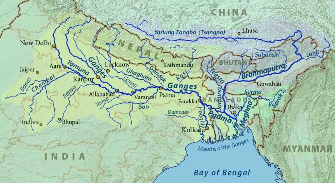
Tributaries of the Ganga River System
The Ganga River System has many tributaries that add to its water and make its drainage network very large. These tributaries are classified based on their origin and the bank they join the main river.
Left Bank Tributaries (Himalayan Origin)
The left bank tributaries originate from the Himalayas and carry substantial amounts of water and sediment:
- Ramganga: Originates from Dudhatoli Hills, Uttarakhand; joins the Ganga near Kannauj.
- Gomti: Originates from Gomat Taal, Pilibhit district, UP; joins the Ganga near Ghazipur.
- Ghaghara: Originates from the Mapchachungo Glacier, Tibet; known as Karnali in Nepal; joins at Chhapra, Bihar.
- Gandak: Originates from the Nepal Himalayas; also called Narayani in Nepal; joins at Sonepur, Bihar.
- Kosi: Originates from the Tibet-Nepal border; notorious as "Sorrow of Bihar" due to frequent floods; joins near Kursela, Bihar
- Mahananda: The Last left bank tributary; originates from the Darjeeling hills.
Right Bank Tributaries (Peninsular Origin)
The right bank tributaries originate from the Peninsular plateau and contribute to the river's flow:
- Yamuna: Longest tributary; originates from Yamunotri Glacier; joins at Prayagraj (Allahabad).
- Son: Known as "Gold River" or "Swarna Nadi"; originates from the Amarkantak Plateau; joins near Patna.
- Damodar: Originates from the Chota Nagpur Plateau; historically called "Sorrow of Bengal".
- Punpun: Originates from the plateaus of Madhya Pradesh.
- Karmanasa: Originates from the Kaimur range; forms the boundary between Bihar and UP.
Also read: Mahanadi River Inter-State Water Dispute
Major Dams and Projects on the Ganga River
The Ganga River has many big projects built for irrigation, flood control, and power. These projects use the river’s water to support farming, energy, and development. Here is the list of dams and major projects:
Dams and Barrages
- Tehri Dam: Located on the Bhagirathi River at Tehri, Uttarakhand; the world's 5th tallest dam at 260.5 meters; power generation capacity of 2,400 MW.
- Farakka Barrage: Built across the Ganga in West Bengal; 2,304 meters long with 109 gates; operational since 1975; designed to flush sediments from Kolkata harbour.
- Ramganga Dam: Constructed at Kalagarh on the Ramganga River for irrigation and power.
River Valley Projects
Multiple river valley projects have been developed to harness the potential of the Ganga system:
- Gandak Project: Joint project of Bihar, UP, and Nepal for hydroelectricity and irrigation.
- Kosi Project: Joint India-Nepal project for flood control, power generation, and irrigation.
- Rihand Project: Built on the Rihand River (tributary of the Son) at Pipri, Sonebhadra, UP.
- Bansagar Project: Joint project on the Son River involving MP, UP, and Bihar.
- Damodar Valley Project: Designed on the Tennessee Valley Authority model for flood control.
Also read: Mount Lewotobi Laki Laki: Indonesia's Active Volcano.
Ganga-Brahmaputra Delta
The Ganga–Brahmaputra Delta (also called the Sundarbans Delta) is the world’s largest river delta, formed by the combined sediment deposits of the Ganga, Brahmaputra, and Meghna rivers.
- Type of Delta: Arcuate-shaped (fan-shaped) delta with a convex curved coastline facing the sea.
- Formation: Created by heavy sediment deposition from multiple rivers, creating a complex network of distributaries and islands.
- Landscape: Includes mangrove forests known as the Sundarbans, tidal rivers, swamps, and fertile alluvial soils.
- Biodiversity: Habitat for the Royal Bengal tiger, estuarine crocodiles, Gangetic dolphins, and numerous bird species.
- Natural Protection: Mangroves act as natural barriers, reducing damage from cyclones and storm surges.
- Environmental Concerns: Vulnerable to sea-level rise, cyclones, erosion, and human activities like deforestation and pollution.
Must read: Biodiversity Hotspots in India: UPSC Notes & Facts
The Ganga River and Its Significance for India
The Ganga River is the lifeline of northern India, providing water, fertile soil, and cultural identity to hundreds of millions of people.
- Water Availability: Provides 29% of India’s total surface water resources.
- Settlements Dependent: Includes 102 cities and 4,512 villages relying on the Ganga for water supply (2023–24).
- Biodiversity Sites: Encompasses 6 Ramsar wetlands and 3 national wildlife sanctuaries, home to the Gangetic dolphin as the national aquatic animal.
- Agricultural Productivity: Irrigates 29 million hectares in the Indo-Gangetic Plain, India’s primary food-grain region.
Challenges and Exploitation of the Ganga River
The Ganga River is badly damaged by too much human use and carelessness. Although it is sacred to many people, it is now one of the most polluted rivers in the world.
- Industrial Waste: Factories dump toxic chemicals into the river.
- Untreated Sewage: Most city sewage flows into the Ganga without proper treatment.
- Excess Water Use: Canals and dams take too much water, drying up parts of the river.
- Farm Runoff: Rain washes pesticides and fertilisers into the river.
- Litter Dumping: Plastic and garbage thrown into the Ganga block flows and harm wildlife.
- Dams’ Impact: Barrages reduce the river’s natural flow, lowering its ability to clean itself.
- Loss of Wildlife: Pollution and overuse endanger river dolphins, crocodiles, and fish.
These are the major challenges faced by the Ganga River, but there are also steps being taken to reduce and control this pollution.
Measures to Clean and Save the Ganga
The Government of India started the Namami Gange Programme to clean the Ganga and bring back its natural health and cultural importance.
- Sewage Treatment Plants (STPs): New STPs are being built in cities like Varanasi and Haridwar to treat wastewater.
- Industrial Pollution Control: Tanneries in Kanpur ordered to set up treatment units before discharging waste.
- River Surface Cleaning: Special teams deployed in Varanasi to remove floating plastic and flowers daily.
- Rural Sanitation: Toilets built under the Swachh Bharat Mission in villages along the Ganga.
- Afforestation: Tree plantation drives in Uttarakhand and Uttar Pradesh to stop soil erosion
- Biodiversity Conservation: Protection of Gangetic dolphins through the National Dolphin Conservation Project.
- Riverfront Development: Modern ghats and electric crematoriums built in Patna and Varanasi to reduce pollution.
- Public Awareness: Campaigns like Clean Ganga Walks and student rallies in river towns.
UPSC Mains Practice Question
Examine the factors responsible for the pollution of the Ganga River. Assess the effectiveness of the Namami Gange Programme in addressing these challenges. (250 words)
Evaluate Your Answers nowConclusion
The Ganga River system UPSC notes are highly relevant for both Geography and Current Affairs preparation. This topic connects directly with Prelims, Mains GS Paper-I (Geography), and GS Paper-III (Environment). A clear understanding of the Ganga River UPSC syllabus helps aspirants link physical geography with sustainable development, governance, and cultural heritage, making it an essential area for exam success.
Supercharge your UPSC prep with SuperKalam, your personal mentor for instant doubt clearing, smart study plans, PYQs practice, and Instant Mains Evaluation.
Explore SuperKalam’s Resources today and take the first step on your path to UPSC success!
SuperKalam: Crack UPSC IAS
Your Personal AI Mentor that teaches, instantly evaluates Handwritten Answers & builds Daily Discipline.
Download the SuperKalam App Now