Why Assam's Embankment Model is Failing the Brahmaputra Basin
Unpacking the systemic collapse of colonial-era structural defenses and the urgent case for holistic basin governance in Assam.
Jul, 2026
•10 min read
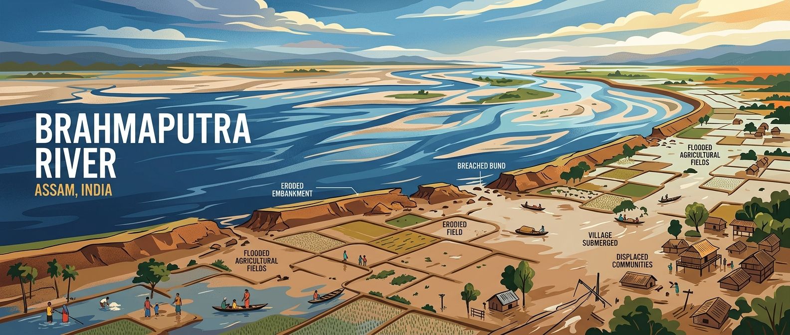
Fig: Assam's extensive network of earthen embankments faces structural stress from heavy sediment loads and annual monsoon discharge.
Assam's reliance on over 4,473 kilometers of embankments along the Brahmaputra River is failing because earthen dikes trap massive sediment, cause riverbed aggradation, and suffer structural degradation beyond their 25-to-30-year lifespan, turning annual monsoon surges into catastrophic breaches across the basin. Constructed primarily since 1954, these traditional dikes prevent natural silt dispersion across floodplains while tectonic instability from the 1950 Assam-Tibet earthquake continues to deposit high sediment loads into river channels. Consequently, out of 31.05 lakh hectares of flood-prone land identified by the Rashtriya Barh Ayog, existing embankments provide protection to only 16.50 lakh hectares. Re-evaluating this structural defense demands integrating transboundary hydrological data sharing, implementing floodplain zoning laws, and establishing empowered regional river basin authorities.
Why in the News?
As of July 2026, recurring monsoon inundations across the Brahmaputra valley have re-ignited intense debate among policy planners over India's reliance on structural flood defenses. The severe destruction caused by annual river breaches underscores the limits of colonial-era engineering solutions in geologically volatile ecological zones.
Riverbank erosion caused by the Brahmaputra and its tributaries has washed away over 4.27 lakh hectares of land in Assam since 1954, amounting to more than 7% of the state's total geographical area. This persistent loss of land, combined with structural failures in the defense grid, has prompted civil engineers, disaster managers, and public policy experts to call for an immediate transition from reactive embankment repair to holistic river basin management.
TL;DR
- High Silt Load & Tectonic Legacy: The Brahmaputra carries over 1 billion tonnes of sediment annually; the 8.6-magnitude 1950 earthquake drastically raised bed levels through massive debris deposits.
- Structural Degradation: Over 4,473 km of embankments built since 1954 have outlived their 25–30 year lifespan, causing artificial riverbed aggradation and frequent breaches.
- Coverage Deficit: Out of 31.05 lakh hectares of flood-prone land identified by the Rashtriya Barh Ayog, current defenses protect only 16.50 lakh hectares.
- Transboundary Vulnerability: India lacks a formal water-sharing treaty with China, relying on non-binding MoUs for data sharing that face periodic geopolitical disruptions.
- Institutional Reforms Delay: Recommendations by the 2004 Task Force to create an autonomous North East Water Resources Authority (NEWRA) remain unfulfilled.
Why the Brahmaputra Floods Demand a New Paradigm
The Brahmaputra River basin in Assam requires a new management paradigm because structural dikes cannot handle the region's steep elevation drops, extreme discharge, and intense tectonic instability. For decades, disaster response in the region has revolved around temporary containment—building higher dikes and throwing geo-bags at crumbling riverbanks.
This engineering response treats a dynamic, high-energy hydrological system as a static canal. By forcing a massive braided river into narrow artificial corridors, containment policies have heightened the hydraulic pressure on surrounding rural habitats during peak monsoon months.
Discuss with Superkalam
What is total length of flood embankments has been built in Assam since 1954, and what is their typical operational design lifespan?
Ask NowUnderstanding the Brahmaputra Basin: Geography and Silt Dynamics
The Brahmaputra River carries the second-highest sediment load per unit drainage area globally, transporting over one billion tonnes of silt annually through the narrow valleys of Assam. This massive sediment yield is driven by the unique physiography of the Himalayan river system.
The river experiences a steep elevation drop from over 5,000 meters in Tibet to under 150 meters upon entering Assam, generating immense kinetic velocity and hydraulic energy during monsoon months. When this high-velocity flow flattens out in the valley, it loses transportation energy, forcing heavy sediment to settle instantly along the riverbed.
Tectonic events have compounded these natural hydrological challenges. The 8.6-magnitude Assam-Tibet earthquake in 1950 drastically altered the riverbed morphology of the Brahmaputra by depositing massive landslide debris into river channels, raising the bed level and increasing post-1950 flood frequency.
Furthermore, over 50 major tributaries feed into the Brahmaputra and Barak rivers within Assam, funneling high-volume rainfall from surrounding mountain ranges into a narrow floodplain valley. The combination of extreme rainfall, fragile geology, and rapid siltation creates a complex landscape that resists simple structural containment.
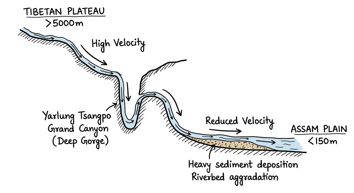
Fig: The steep elevation drop from Tibet to the Assam valley generates high kinetic energy, resulting in heavy sediment deposition as the river gradient flattens.
Discuss with Superkalam
In your own words, explain how forcing a high-energy braided river into artificial dikes leads to riverbed aggradation.
Ask NowHow the Embankment-Centric Approach Became the Default Response
The Water Resources Department of Assam adopted embankments as its chief flood mitigation tool following the devastating 1954 floods, constructing extensive earthen networks across the valley. Dikes offered an immediate, visible, and low-cost mechanism to protect human settlements and agricultural fields from seasonal overflow.
Assam's Water Resources Department has constructed over 4,473 kilometres of flood embankments across the Brahmaputra and Barak valleys as its primary structural defense since 1954. These structures were designed under the assumption that rivers could be permanently locked within designated channels.
Metric / Dimension | Verified Value / Status | Primary Source Anchor |
Total Embankment Length | > 4,473 kilometres | Water Resources Department, Government of Assam |
Land Lost to Erosion (Since 1954) | > 4.27 lakh hectares (> 7% of state area) | Water Resources Department, Government of Assam |
Annual Sediment Transport | > 1 billion tonnes | Water Resources Department, Government of Assam |
Flood-Prone Area Identified | 31.05 lakh hectares | Rashtriya Barh Ayog / Assam WRD |
Protected Flood Area | 16.50 lakh hectares | Water Resources Department, Government of Assam |
This engineering policy left significant protection gaps across the state. Out of 31.05 lakh hectares of flood-prone area in Assam identified by the Rashtriya Barh Ayog, existing structural measures provide reasonable protection to only 16.50 lakh hectares
Where the System Breaks Down: Why Traditional Defenses Fail
Assam's flood embankments suffer from severe structural degradation because most dikes have exceeded their operational lifespan of 25 to 30 years without undergoing systematic modernization. Built largely with local earthen materials in the post-1954 decades, these structures cannot withstand modern peak discharge levels.
Continuous earthen embankment confinement prevents natural silt spreading across floodplains, trapping heavy sediment loads within the riverbed and causing riverbed aggradation. Aggradation refers to the progressive raising of a river channel bed due to the accumulation of deposited sediment over time. As the bed rises, the river's water level frequently sits higher than the adjacent floodplain countryside, making any structural dike breach catastrophic.
Dynamic riverbank erosion continuously undermines the bases of these earthen dikes. Riverbank erosion caused by the Brahmaputra and its tributaries has washed away over 4.27 lakh hectares of land in Assam since 1954, amounting to more than 7% of the state's total geographical area. When dikes collapse, they unleash high-velocity torrents loaded with silt, damaging standing crops and depositing infertile sand over productive farmland.
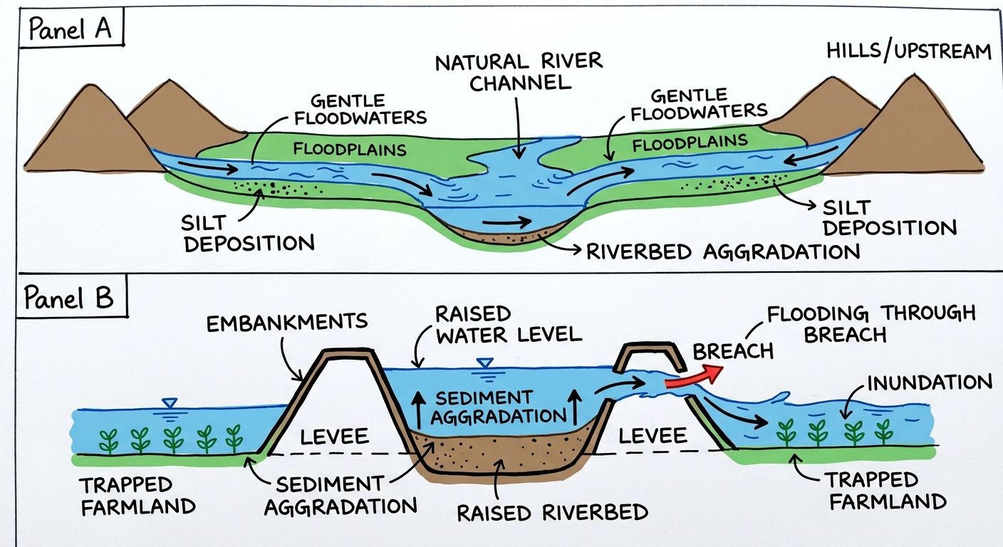
Fig: Continuous confinement by earthen embankments prevents natural silt distribution, raising the riverbed above the surrounding land level.
Discuss with Superkalam
How would you apply the article's data on riverbank erosion to evaluate agricultural risk in a flood-prone district of Assam?
Ask NowThe Transboundary Blindspot: Upstream Dams and Data Sharing with China
India and China manage transboundary flows of the Yarlung Zangbo—known as the Brahmaputra in Assam—through non-binding bilateral Memoranda of Understanding rather than a formal water-sharing treaty. This lack of a formal treaty leaves downstream riparian states vulnerable to upstream hydrological variations and operational shifts.
Under bilateral MoUs initiated in 2002, China agreed to supply flood-season hydrological data twice daily from three Tibetan monitoring stations—Nugesha, Yangcun, and Nuxia—to assist Indian flood forecasting. This data provides early warning signals regarding runoff volumes entering Arunachal Pradesh and Assam.
Geopolitical tensions have periodically disrupted these critical hydrological information flows. China unilaterally suspended the transmission of hydrological data to India during the 2017 Doklam standoff, citing damage to data collection facilities in Tibet.
Per a Ministry of Jal Shakti RTI response (as reported by India Today in May 2024), China has not shared hydrological data for the Brahmaputra with India since 2022 following the MoU expiration in June 2023. Without verified real-time upstream discharge figures, downstream flood forecasting models lose accuracy during heavy monsoons.
Lessons from Past Blueprints: What the 2004 Task Force Recommended
The Union Government constituted a 21-member Task Force on Flood Management under the Central Water Commission Chairman following catastrophic monsoons in 2004 to overhaul regional infrastructure strategies. The panel reviewed the structural performance of dikes and recommended replacing piecemeal repairs with integrated basin governance.
The 2004 Task Force on Flood Management recommended establishing an empowered statutory body, the North East Water Resources Authority (NEWRA), with financial and managerial autonomy to manage the basin holistically. NEWRA was designed to replace the Brahmaputra Board, integrating hydro-power generation, erosion control, and flood management under a single authority.
Inter-state friction and administrative inertia have stalled the creation of NEWRA. Upstream states expressed concerns over land submerged by storage reservoirs, leaving the Brahmaputra Board operating with limited execution powers and inadequate funding.
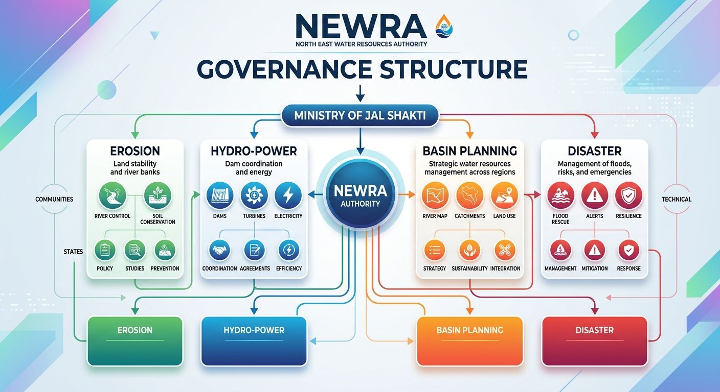
Fig: The 2004 Task Force recommended an empowered North East Water Resources Authority (NEWRA) to replace fragmented regional water bodies.
Moving Beyond Reactive Relief: The Case for Floodplain Zoning
Floodplain zoning regulates land use within river channels and flood-prone areas across Assam to minimize economic damage and human displacement during annual monsoon inundations. Non-structural approaches emphasize mapping river corridors and designating land use zones based on flood frequency and risk levels.
Although non-structural flood management models have been discussed regionally for decades, enforcement faces severe socio-economic hurdles in Assam. High population density, land scarcity, and human displacement caused by severe riverbank erosion force vulnerable communities to inhabit high-risk riverine sandbars (chars) and embankments.
Successful floodplain zoning requires clear legal definitions, spatial mapping, and alternative land allocations for displaced populations. Without administrative support and re-housing schemes for victims of erosion, land-use restrictions remain difficult to enforce on the ground.
A Sustainable Roadmap for Flood Management in Assam
The Ministry of Jal Shakti must transition Assam's disaster strategy from temporary embankment repair toward integrated river basin management and institutional restructuring. Addressing the Brahmaputra crisis requires combining structural maintenance, non-structural land planning, and regional hydro-diplomacy.
Key strategic imperatives include:
- Operationalising Apex Basin Governance: Establish the proposed North East Water Resources Authority (NEWRA) with statutory autonomy to unify inter-state water management across the North Eastern region.
- Selective De-embankment & Controlled Inundation: Strategic retirement of obsolete embankments that have outlived their 25-to-30-year lifespan, allowing river discharge to spread safely into designated wetlands (beels) to trap silt.
- Dredging and Morphological Management: Target mechanical dredging at major river chokepoints to mitigate aggradation and restore natural carrying capacity.
- Strengthening Transboundary Hydro-Diplomacy: Formalise data-sharing protocols with China through permanent agreements, moving past short-term, non-binding MoUs.
- Enforcing Non-Structural Zoning: Implement spatial mapping and floodplain zoning laws while building flood-resilient infrastructure for riverine communities.
Discuss with Superkalam
Evaluate whether setting up NEWRA with statutory powers is viable given inter-state concerns regarding storage reservoir land submergence.
Ask NowPractice — Prelims MCQs
QUESTION 1
Q1. Consider the following statements regarding the physical and sediment dynamics of the Brahmaputra River basin in Assam:
- The river experiences an elevation drop from over 5,000 metres in Tibet to under 150 metres upon entering Assam.
- The river carries over one billion tonnes of sediment annually, leading to riverbed aggradation when flow velocity decreases in the valley.
- The 1950 Assam-Tibet earthquake reduced sediment load in the riverbed by stabilizing riverbank slopes.
Which of the statements given above are correct?
QUESTION 2
Q2. Consider the following statements regarding flood defenses and land loss in Assam:
- Existing embankments provide reasonable protection to less than 60% of the flood-prone area identified by the Rashtriya Barh Ayog in Assam.
- Riverbank erosion caused by the Brahmaputra and its tributaries since 1954 has washed away over 7% of Assam's total geographical area.
- Most flood embankments in Assam were constructed with a design lifespan exceeding 75 years.
Which of the statements given above is/are correct?
Mains Question
The 2004 Task Force on Flood Management recommended establishing an empowered statutory body, the North East Water Resources Authority (NEWRA), to integrate basin governance. Discuss the institutional and political factors that have delayed its operationalization.
Evaluate Now