TRISHNA Satellite Mission: Resolving Earth's Thermal Blind Spot
By resolving the trade-off between spatial sharpness and revisit frequency, TRISHNA equips policymakers with plot-level thermal data for climate adaptation.
Oct, 2026
•12 min read
Overview
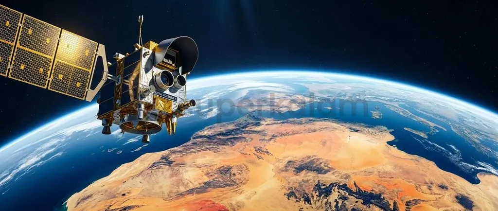
The TRISHNA satellite mission, developed jointly by the Indian Space Research Organisation and France's National Centre for Space Studies, bridges a critical Earth observation gap by pairing high-resolution thermal imaging with rapid revisit capabilities to track land surface temperatures and water stress at plot scale. Operating across thermal infrared and optical bands, the mission resolves fine-scale thermodynamic exchanges across agricultural fields, urban heat islands, and sensitive coastal waters. Conventional satellite sensors historically forced scientists to sacrifice spatial sharpness for frequent orbital revisits. TRISHNA breaks this constraint through an orbital design that delivers gridded thermal data every two to three days. This continuous thermodynamic monitoring equips policymakers with empirical indicators for climate adaptation, water conservation, and agricultural resilience.
Why TRISHNA Is in the News
The Indian Space Research Organisation (ISRO) and France's Centre National d'Études Spatiales (CNES) have advanced joint engineering preparations for the TRISHNA Earth-observation mission. TRISHNA stands for Thermal Infra-Red Imaging Satellite for High-resolution Natural Resource Assessment, establishing a dedicated spaceborne platform to measure global land surface temperatures. As of late 2026, the launch of TRISHNA aboard a Polar Satellite Launch Vehicle (PSLV) from Sriharikota is officially targeted for the 2027 launch window following hardware deliveries and joint integration milestones.
The project represents a central pillar of Indo-French bilateral scientific cooperation. By placing an advanced thermal imager into a sun-synchronous orbit, the two space agencies seek to track global water cycles and surface energy budgets. The resulting datasets will supply continuous inputs to international climate and agricultural monitoring consortia, including the Group on Earth Observations Global Agricultural Monitoring Initiative (GEOGLAM).
The Thermal Blind Spot: Why Earth's Heat Is Hard to Map from Space
Earth's thermal infrared radiation presents an inherent physical detection challenge for spaceborne sensors operated by space agencies like ISRO. Optical remote sensing measures solar radiation reflected from the planet's surface, mostly within visible and near-infrared wavelengths. In contrast, thermal remote sensing captures radiation that the terrestrial surface absorbs, processes, and re-emits as heat.
According to a research review on thermal remote sensing, terrestrial thermal imaging operates predominantly in the long-wave infrared window between 8 and 14 micrometres (µm). Emitted photon energy across this long-wave spectrum is fundamentally lower than reflected solar radiation. Because the terrestrial surface emits lower-energy photons, satellite detectors record a substantially weaker signal per unit area than standard optical cameras.
This physical disparity creates a signal-to-noise bottleneck for sensor engineers. Satellite instruments must gather a sufficient quantity of photons to distinguish subtle temperature fluctuations from background electronic noise. To collect enough energy, traditional thermal sensors required large ground instantaneous fields of view, which degraded spatial sharpness.
Instruments designed for sharp spatial detail had to narrow their optical swath, lengthening orbital revisit times. Earth observation was thus left with a thermal blind spot: scientists could observe broad regional temperatures daily, or examine microscale landscapes once every few weeks, but could never achieve both simultaneously.
Discuss with Superkalam
Which specific atmospheric transmission window does TRISHNA's French-built Thermal Infra-Red payload utilise to measure Land Surface Temperature?
Ask NowHow TRISHNA Solves the Spatial Versus Revisit Trade-Off
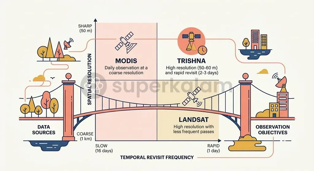
The TRISHNA mission architecture resolves the long-standing operational compromise between spatial detail and revisit frequency in satellite thermal imaging. Historically, satellite missions operated at polar extremes of the observation spectrum, as noted in an EGUsphere study on TRISHNA. Missions like the American Landsat series provided thermal resolutions between 60 and 100 metres but required 16 days between successive passes over the same location.
Conversely, wide-swath sensors like MODIS aboard NASA's Terra and Aqua satellites, or the European Sentinel-3 constellation, provide near-daily temporal revisit rates. However, their coarse spatial resolution of approximately one kilometre averages temperature across vast tracts, obscuring fragmented land holdings and distinct urban neighbourhoods.
| Observation Dimension | Coarse Thermal Sensors (MODIS / Sentinel-3) | High-Resolution Legacy Sensors (Landsat Series) | TRISHNA Mission Architecture |
|---|---|---|---|
| Spatial Resolution | ~1,000 metres (coarse) | 60 to 100 metres (fine) | ~50 to 60 metres gridded (fine) |
| Temporal Revisit | 1 to 2 days (rapid) | 16 days (slow) | 2 to 3 days average (rapid) |
| Primary Limitation | Blurs small farm plots and urban structures | Misses rapid soil moisture and drought shifts | Requires complex dual-sensor data fusion |
| Operational Focus | Global atmospheric and oceanic models | Geological mapping and historical baselines | Precision irrigation and microclimate management |
According to official mission specifications from CNES, TRISHNA circumvents this trade-off by delivering a high spatial resolution with a 60-metre gridded product alongside a temporal revisit rate of three acquisitions every eight days, averaging an observation every two to three days. The spacecraft achieves this coverage by orbiting at an altitude of 761 kilometres in a sun-synchronous polar trajectory.
The mission has an early-afternoon descending equatorial crossing time of 12:30 PM. This orbit ensures that the spacecraft observes land surfaces when diurnal solar heating reaches its peak, maximising thermal contrast across soil, vegetation, and built infrastructure. The mission has a baseline operational design life of five years, with planned extensions of up to two years.
Discuss with Superkalam
Why does lower photon energy in the long-wave infrared spectrum force sensor engineers to trade off spatial resolution against revisit frequency?
Ask NowDivision of Labour: What ISRO and CNES Are Building
The TRISHNA mission relies on a complementary division of engineering responsibilities between ISRO and the French space agency CNES. Rather than duplicating hardware development, the two agencies share payload and platform responsibilities based on their institutional capabilities, as outlined in the ISRO Official Mission Release.
The French space agency CNES leads development of the primary Thermal Infra-Red (TIR) payload. According to IN-SPACe technical documentation, this instrument features four spectral channels operating within the 8.6 to 11.5 micrometre atmospheric transmission window. These channels isolate long-wave terrestrial radiance to retrieve Land Surface Temperature and calculate surface emissivity across varying topographies.
ISRO develops the complementary Visible - Near Infra-Red - Short Wave Infra-Red (VNIR-SWIR or VSWIR) payload comprising seven optical spectral bands. While the French instrument measures surface heat, ISRO's optical sensor assesses surface reflectance, vegetation greenness, albedo, and atmospheric water vapour. Integrating optical and thermal measurements on a single platform allows researchers to evaluate how solar energy transforms into latent and sensible heat.
ISRO provides the satellite platform, integrating both payloads onto its modular IRS-1K bus, as noted in Department of Space records. The agency will launch TRISHNA aboard its Polar Satellite Launch Vehicle (PSLV) from the Satish Dhawan Space Centre in Sriharikota.
Operational ground processing is jointly shared across ISRO centres—including the Space Applications Centre in Ahmedabad, U R Rao Satellite Centre in Bengaluru, and National Remote Sensing Centre in Hyderabad—in tandem with CNES facilities in Toulouse.
Discuss with Superkalam
How can irrigation authorities use TRISHNA's plot-scale evapotranspiration datasets to adjust canal water distribution during a dry spell?
Ask NowFrom Thirsty Crops to Burning Cities: Key Applications for India
TRISHNA equips Indian planners with high-resolution thermodynamic datasets to mitigate agricultural drought risks and manage expanding urban heat islands. By pairing thermal observations with optical reflectance, the satellite platform resolves the surface energy balance to calculate actual evapotranspiration at farm-plot scale.
Evapotranspiration measures the total loss of water transferred to the atmosphere through soil evaporation and plant transpiration. In water-stressed agricultural economies, this metric reveals how much moisture crops consume in real time.
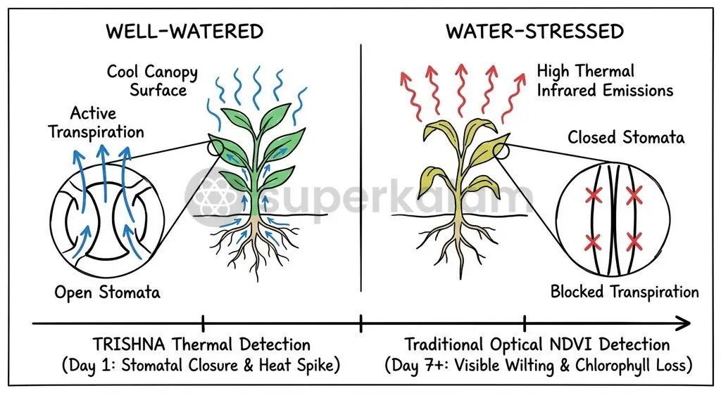
Thermal monitoring identifies agricultural water stress well before conventional optical remote sensing indices, such as the Normalised Difference Vegetation Index (NDVI), detect visible wilting. When soil moisture drops, plants close their microscopic leaf pores—stomata—to reduce water loss.
Stomatal closure suppresses transpiration, which normally cools the canopy, driving leaf temperatures up immediately. Optical sensors only detect moisture deficits days later, after chlorophyll breaks down and foliage wilts. TRISHNA's thermal observations detect this temperature surge within hours, giving irrigation authorities an early warning mechanism to direct canal discharges and borewell water before crops suffer irreversible damage.
Beyond agriculture, TRISHNA's high spatial resolution maps microscale Urban Heat Islands across Indian metropolises. The sensor differentiates temperatures between individual building complexes, arterial transport corridors, concrete expanses, and urban tree canopies. Municipal authorities can use this spatial detail to formulate evidence-based heat action plans, target cool-roof installations, and design urban green corridors.
The satellite also monitors aquatic ecosystems by measuring lake water temperature stratification, tracking industrial thermal plumes along coastlines, and identifying submarine groundwater discharge zones where fresh aquifers empty into coastal seas.
Discuss with Superkalam
Compare the diagnostic capability of TRISHNA's thermal channels with traditional optical indices like NDVI during the onset of crop moisture stress.
Ask NowBenchmarking TRISHNA Against Global Thermal Monitors
International Earth observation initiatives increasingly recognise that high-resolution thermal imaging is essential for tracking climate impacts across terrestrial biomes. TRISHNA does not operate as an isolated sensor; mission designers structured its parameters to complement upcoming global thermal constellations, as highlighted during the 2nd International Workshop on High Resolution Thermal Earth Observation.
The mission aligns with the European Space Agency's planned Copernicus Land Surface Temperature Monitoring (LSTM) satellite and NASA's Surface Biology and Geology (SBG) thermal mission. Operating alongside these international sensors will build an informal thermal constellation, shortening effective global revisit intervals to under twenty-four hours.
| Mission | Developing Agencies | Spatial Resolution | Orbit Profile & Revisit | Primary Focus |
|---|---|---|---|---|
| TRISHNA | ISRO (India) & CNES (France) | ~50 to 60 m gridded | Sun-synchronous (761 km); 2 to 3 days revisit | Evapotranspiration, crop water stress, urban heat islands |
| ECOSTRESS | NASA (United States) | ~70 metres | Precessing orbit aboard ISS; variable revisit | Diurnal cycle experiments, plant transpiration dynamics |
| Copernicus LSTM | ESA (European Union) | ~50 metres | Sun-synchronous orbit; multi-day revisit | European and global agricultural water management |
| SBG-Thermal | NASA (United States) | ~60 metres | Sun-synchronous orbit; multi-day revisit | Volcanic activity, hydrology, agricultural ecosystems |
NASA's ECOSTRESS payload aboard the International Space Station proved the value of high-resolution thermal observations by recording plant transpiration dynamics across varying times of day. However, because the space station follows an inclined, precessing orbit, ECOSTRESS cannot provide systematic global coverage with consistent revisit intervals.
TRISHNA addresses this limitation by using a sun-synchronous polar orbit, providing stable sun angles and consistent revisit cadences. This dependable coverage produces structured time-series data suitable for national hydrological budgets and automated agricultural advisories.
Discuss with Superkalam
Assess the strategic value of joint international missions like TRISHNA for India's domestic climate adaptation planning and space diplomacy.
Ask NowStrategic Takeaways for India's Space Diplomacy and Climate Policy
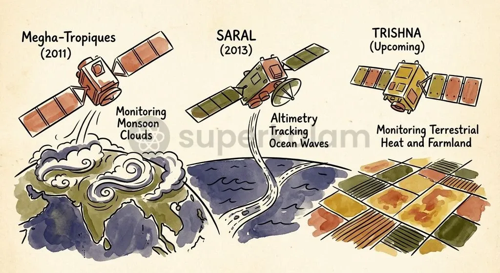
The TRISHNA partnership reflects a mature bilateral space relationship between India and France anchored in climate science and joint engineering. Joint space initiatives between the two countries date back decades, and TRISHNA marks their third dedicated bilateral Earth-observation satellite collaboration.
The partnership previously developed the Megha-Tropiques satellite, launched in October 2011 to analyse the tropical water cycle, convective cloud systems, and monsoon rainfall dynamics.
Building on that success, the two nations launched SARAL (Satellite with ARgos and ALtiKa) on 25 February 2013. SARAL paired CNES's Ka-band radar altimeter (AltiKa) with an ISRO satellite bus, delivering ocean surface topography data for marine meteorology and sea-level monitoring. TRISHNA continues this operational model: France provides advanced sensor instrumentation, while India supplies the spacecraft platform, optical payloads, and launch services.
This cooperative model shows how space diplomacy expands national scientific capabilities while conserving public resources. Partnering with CNES allows ISRO to access specialised multi-channel thermal infrared sensors without financing independent sensor design from scratch.
Concurrently, French scientists secure cost-effective launch capabilities aboard the PSLV and operational access to diverse tropical and subtropical test sites across the Indian subcontinent.
For domestic climate policy, deploying TRISHNA is only the first step. Indian planning bodies must build data pipelines connecting satellite thermal measurements to agricultural extension networks. Raw land surface temperatures must be processed into actionable metrics—such as soil moisture deficits and canal distribution priorities—and delivered directly to district water authorities and farming communities.
Integrating space-based thermal sensing into municipal heat action plans will help Indian cities address extreme summer temperatures using empirical, block-level heat data.
Key Takeaways
- The Core Innovation: TRISHNA resolves Earth observation's thermal blind spot by combining high spatial resolution (approximately 50 to 60 metres) with a rapid revisit cadence of two to three days in a sun-synchronous polar orbit.
- Overcoming Physical Bottlenecks: Capturing terrestrial long-wave infrared radiation (8 to 14 µm) is constrained by low photon energy, creating a signal-to-noise challenge that historically forced space agencies to sacrifice either spatial sharpness or revisit frequency.
- Shared Bilateral Responsibilities: The French space agency CNES supplies the four-channel Thermal Infra-Red (TIR) instrument, while ISRO develops the seven-channel optical (VSWIR) payload, the IRS-1K satellite platform, and provides launch services aboard the PSLV from Sriharikota.
- Agricultural Early Warning: Thermal monitoring detects crop moisture deficits days before conventional vegetation indices (like NDVI) identify visible wilting, because stomatal closure immediately elevates canopy temperatures.
- Urban Heat Management: The platform's 60-metre gridded thermal observations map microscale Urban Heat Islands, isolating heat retention across individual building clusters, transit roads, and open greenspaces.
- Deep Bilateral Synergy: TRISHNA represents the third dedicated Earth observation satellite jointly developed by ISRO and CNES, following the successful Megha-Tropiques (2011) and SARAL (2013) climate missions.
Mains Question
"By pairing high-resolution thermal imaging with rapid revisit capabilities, the TRISHNA mission addresses a long-standing operational compromise in Earth observation." Elucidate the technological bottleneck in spaceborne thermal sensing and examine how TRISHNA's mission architecture resolves it. (10 Marks)
Evaluate NowMains Question
"Thermal remote sensing provides critical real-time diagnostic inputs for climate adaptation that conventional optical indices fail to capture in time." In this context, evaluate the utility of the Indo-French TRISHNA satellite mission for agricultural resilience and urban microclimate management in India. (15 Marks)
Evaluate NowPractice MCQs
QUESTION 1
Regarding the physical principles of spaceborne thermal remote sensing mentioned in the context of TRISHNA, consider the following statements:
- Unlike optical remote sensing which measures reflected solar radiation, thermal remote sensing captures radiation absorbed and re-emitted by the Earth's surface as heat.
- Terrestrial thermal imaging operates primarily in the long-wave infrared window between 8 and 14 micrometres.
- Because terrestrial surfaces emit higher-energy photons than reflected solar rays, thermal sensors achieve superior signal-to-noise ratios at narrow swaths. Which of the statements given above is/are correct?
QUESTION 2
In the context of agricultural monitoring, why does TRISHNA's thermal imaging detect crop water stress earlier than conventional optical indices like NDVI?
QUESTION 3
Why is the TRISHNA satellite placed in an orbit with an early-afternoon descending equatorial crossing time of 12:30 PM?