PM GatiShakti: Has Integrated Planning Solved Infrastructure Delays?
While 23,493 GIS layers streamline front-end approvals, on-ground land acquisition and municipal utility gaps still test India's infrastructure delivery.
Oct, 2026
•10 min read
Overview
The PM GatiShakti National Master Plan systematically digitises infrastructure appraisal across fifty-eight central ministries to eliminate departmental silos. Yet persistent structural bottlenecks in physical land acquisition and municipal utility mapping prevent upfront planning efficiencies from completely eliminating chronic project delays.
Launched by Prime Minister Narendra Modi on 13 October 2021, the platform operationalises a three-tier institutional machinery. This setup unites apex executive oversight with spatial mapping developed by the Bhaskaracharya National Institute for Space Applications and Geo-informatics.
The institutional architecture has compressed pre-construction survey timelines and harmonised multi-modal connectivity for hundreds of central mega-projects worth trillions of rupees. Bridging digital spatial coordination with state-level revenue administration remains vital to lowering India's logistics costs to competitive global benchmarks.
Why in the News: Moving Beyond Silos in Mega Infrastructure
The PM GatiShakti National Master Plan completed five years of operations on 13 October 2026, marking an institutional transition toward synchronised, multi-modal infrastructure planning. As of October 2026, the national platform onboards 58 Central Ministries and Departments alongside all 36 States and Union Territories, according to the Press Information Bureau. This whole-of-government model directly addresses chronic delays that historically plagued public capital works.
Before this reform, central infrastructure departments operated as administrative islands. Road-building authorities, railway divisions, and telecommunication agencies worked on disconnected master schedules. The resulting governance failure frequently saw newly paved national highways dug up to lay water pipelines or underground electrical conduits.
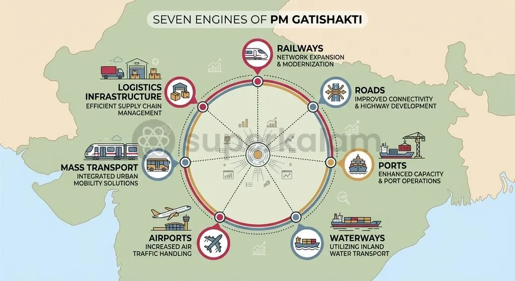
To anchor mega-projects to a shared technological baseline, the platform unifies spatial planning across seven core infrastructure engines:
- Railways and Roads
- Ports and Waterways
- Airports
- Mass Transport
- Logistics Infrastructure
This framework provides the physical backbone for reducing systemic supply-chain frictions across the national economy.
The Governance Bottleneck: Why Coordination Failures Cost Billions
Central infrastructure ministries historically operated within rigid bureaucratic silos. This setup produced fragmented corridor approvals, uncoordinated utility excavations, and severe capital overruns across transportation networks.
The Cabinet Committee on Economic Affairs noted that inter-departmental fragmentation forced project developers through sequential rather than synchronised statutory sanctions. A railway corridor proposal could spend years securing forest permissions, only to discover that an intersecting national highway authority planned a parallel flyover along the identical right-of-way.
These coordination breakdowns imposed staggering economic burdens on public finances. Monitoring data from the Ministry of Statistics and Programme Implementation shows that cost overruns exceeding ₹2.8 lakh crore persist across central sector projects valued at ₹150 crore and above. While digital master planning coordinates corridor design, civil works continue to absorb the fiscal shock of prolonged administrative delays.
Uncoordinated project implementation generated three recurring structural bottlenecks across public agencies:
- Sequential Inter-Ministerial Clearances: Environmental, railway, and highway permissions were processed linearly, multiplying pre-construction gestation timelines.
- Repeated Utility Disruption: Newly built trunk highways were routinely cut by municipal bodies or utility agencies lacking visibility over subsurface networks.
- Disconnected Freight Terminals: Industrial production hubs frequently developed without dedicated first-mile and last-mile railway siding connections or dry-port links.
Discuss with Superkalam
Recall the financial threshold above which infrastructure projects must secure mandatory appraisal from the Network Planning Group.
Ask NowThe Mechanism: How the GIS Platform Intersects with Project Approvals
The Bhaskaracharya National Institute for Space Applications and Geo-informatics indigenously developed the PM GatiShakti platform, combining geospatial data layers with an integrated three-tier governance architecture. The digital platform incorporates satellite imaging and spatial analytical tools to provide an exhaustive digital twin of India's physical assets. As of 12 October 2026, the National Master Plan incorporates over 23,493 geospatial data layers, covering everything from reserve forest boundaries to existing gas pipelines.
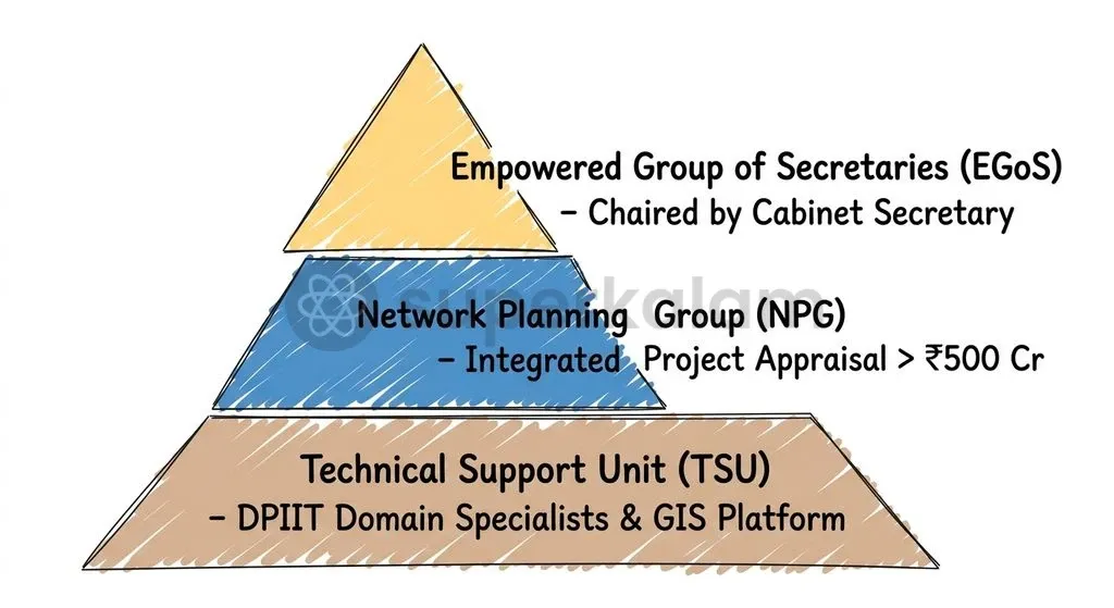
This technical backbone operates under a rigorous three-tier administrative machinery designed to enforce multi-modal integration before project financing receives formal sanction:
- Empowered Group of Secretaries (EGoS): Chaired ex officio by the ****, this apex body consists of Secretaries from infrastructure and user ministries. The Head of the Logistics Division within the Department for Promotion of Industry and Internal Trade (DPIIT) is its Member Convenor. The EGoS monitors framework implementation and adjudicates inter-ministerial disputes.
- Network Planning Group (NPG): Operating beneath the EGoS, the NPG brings together the heads of planning divisions across connectivity ministries. The group convenes fortnightly to evaluate infrastructure proposals, verifying whether a project incorporates shared right-of-way utilities and multimodal logistics access.
- Technical Support Unit (TSU): Housed inside DPIIT's Logistics Division, this multidisciplinary unit employs specialised domain experts across aviation, maritime, rail, highway, and GIS analytics to conduct detailed spatial assessments for the NPG.
To enforce compliance, the Ministry of Commerce and Industry established a strict financial threshold. All central connectivity proposals with a project cost exceeding ₹500 crore must secure formal NPG appraisal before submission to the Public Investment Board or the Expenditure Finance Committee.
| Parameter | Traditional Project Planning | PM GatiShakti Master Planning |
|---|---|---|
| Data Architecture | Fragmented departmental paper maps | Unified digital GIS platform with 23,493+ layers |
| Clearance Sequence | Sequential inter-ministerial approvals | Synchronised spatial appraisal prior to DPR |
| Mandatory Threshold | Departmental discretion | Mandatory NPG appraisal for projects above ₹500 crore |
| Right-of-Way Coordination | Isolated utility cutting and laying | Common corridors planned for roads, rail, and pipelines |
| Private Sector Access | Opaque institutional access | Query-based visibility via PM GatiShakti Public |
Discuss with Superkalam
Explain how the transition from sequential clearances to synchronized spatial appraisals reduces pre-construction gestation periods.
Ask NowOn-Ground Impact: Where Multi-Modal Planning Worked and Where It Stalled
The Network Planning Group evaluated 396 mega projects worth approximately ₹18.66 lakh crore by August 2026, accelerating pre-construction approvals while physical implementation bottlenecks persisted. The platform delivered significant gains during the pre-construction survey phase, where spatial overlay analysis replaced cumbersome ground verification. Detailed project reports that previously took months to align were completed in fractions of that time.
Departmental case data highlights rapid improvements in front-end surveying:
- Railway Alignment Acceleration: The Ministry of Railways finalised 449 Final Location Surveys in FY 2021-22 using the GIS platform, up from just 57 surveys in FY 2020-21.
- Pipeline Route Approvals: The Ministry of Petroleum and Natural Gas deployed the electronic Detailed Route Survey (eDRS), compressing survey timelines from 6–9 months down to several hours.
- Digital Freight Convergence: The Unified Logistics Interface Platform integrated 46 systems across 12 Central Ministries using 142 Application Programming Interfaces (APIs), enabling real-time cargo movement visibility.
- Institutional Capacity Building: Gati Shakti Vishwavidyalaya in Vadodara, established in 2022, trained over 2.4 lakh public officials in integrated multi-modal engineering by July 2026.
These planning reforms support targets outlined in the National Logistics Policy, launched on 17 September 2022 to lower logistics costs from 13–14% of GDP down to global single-digit benchmarks. India advanced six positions to rank 38 out of 139 nations in the World Bank's Logistics Performance Index 2023, targeting the global top 25 by 2030.
Yet significant limitations remain evident during civil execution. While GIS screens identify optimal corridors, they cannot resolve contractor cash-flow crises, local environmental opposition, or physical labour shortages. As MoSPI monitoring confirms, pre-construction planning alone cannot insulate mega-projects from mid-stream execution overruns once construction begins on the ground.
Discuss with Superkalam
Imagine an urban metro rail extension encountering undocumented municipal pipelines; how would you apply the PM GatiShakti GIS framework to prevent such disruptions?
Ask NowFederal and Institutional Frictions: Centre-State Alignment and Capacity Deficits
State revenue departments and municipal authorities face substantial capacity deficits, limiting the ground-level effectiveness of digital alignment data during physical project execution. Physical infrastructure eventually lands on state and municipal soil, where constitutional authority over land, local roads, and municipal permissions resides. When central spatial designs encounter fragmented local administration, pre-construction momentum stalls.
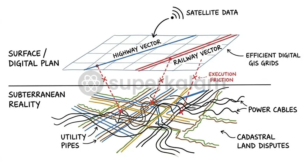
Physical land acquisition governed by state revenue acts remains the leading cause of delay. GIS corridor mapping identifies the most efficient spatial path. However, satellite layers cannot resolve disputed land ownership, negotiate compensation under local legislation, or expedite judicial appeals. State revenue offices frequently lack digital cadastral maps, forcing surveyors to reconcile digital satellite layers against colonial-era paper land registries.
Municipal utilities present an equally severe operational barrier. Urban Local Bodies rarely possess digitised subsurface maps for municipal water mains, sewer lines, or city power distribution grids. Contractors undertaking urban rail or bypass projects frequently encounter undocumented underground pipes, triggering emergency utility relocations that stop construction work.
To address these federal imbalances, the Union Government deployed dedicated administrative interventions:
- Fiscal Incentive Schemes: The Ministry of Finance allocated ₹5,000 crore in 50-year interest-free loans under the Scheme for Special Assistance to States for Capital Investment to encourage State Master Plan creation and data onboarding.
- Grassroots Administrative Portals: The Ministry of Commerce and Industry launched the District Master Plan portal across 27 aspirational districts in October 2024, aiming to extend spatial tools across more than 750 districts.
- Commercial Data Access: The government introduced the 'PM GatiShakti Public' platform in October 2025, providing private entities query-based access to 230 non-sensitive datasets for private logistics planning.
- Statutory Master Planning: The Union Cabinet approved the Integrated Transport & Logistics Authority in October 2026 to govern a 10-year rolling National Transport Master Plan.
Discuss with Superkalam
Compare the impact of digital spatial mapping at the pre-construction survey stage with the institutional bottlenecks faced during civil execution.
Ask NowWay Forward: Institutionalising Last-Mile Coordination
The Integrated Transport & Logistics Authority must align digital planning with local execution by statutory integration of subsurface utility maps and modernised state land records. Integrated spatial planning represents a durable shift in public administration. However, extracting its full economic return requires tackling ground-level execution friction. Digital mapping provides administrative visibility, but statutory reforms provide execution capability.
To bridge this implementation divide, action is required across three tiers of governance:
- Land Records Harmonisation: States must accelerate revenue administration modernisation. Aligning the Digital India Land Records Modernisation Programme with State Master Plans will eliminate discrepancies between GIS corridor routes and actual land ownership deeds. States should also enact standardised corridors-of-right laws to shield linear clearances from protracted litigation.
- Subterranean Utility Mapping: Municipal governments must build subterranean spatial databases. Urban development grants should require city agencies to map underground water lines, electrical cabling, and sewage networks. Mandating subsurface utility data on state master plans will prevent unexpected pipe ruptures during urban transport construction.
- Post-Appraisal Construction Tracking: Administrative agencies must bridge the gap between initial appraisals and ongoing civil work. The Network Planning Group's mandate should extend beyond initial Detailed Project Report reviews to track project milestones through the National Transport Data Repository. Equipping district collectors through District Master Plans will ensure that boardroom efficiencies translate into rapid delivery on the ground.
Key Takeaways
- The PM GatiShakti National Master Plan completed five years of operations on 13 October 2026, transitioning Indian capital planning from departmental silos into an integrated digital GIS framework.
- Platform governance operates through a three-tier institutional machinery: the Empowered Group of Secretaries (apex), the Network Planning Group (operational review), and the Technical Support Unit (technical analysis).
- All central connectivity and logistics proposals exceeding ₹500 crore require mandatory Network Planning Group appraisal before securing investment board approval.
- Developed by BISAG-N, the platform integrates over 23,493 geospatial data layers across 58 Central Ministries and all 36 States and Union Territories.
- Digital survey tools have significantly cut front-end route finalisation times, as demonstrated by the Ministry of Railways completing 449 Final Location Surveys in FY 2021-22.
- Pre-construction digital mapping has not eliminated post-award delays, with MoSPI tracking over ₹2.8 lakh crore in cost overruns driven primarily by state-level land acquisition and municipal utility disconnects.
Mains Question
"Digital spatial master planning through platforms like PM GatiShakti can streamline front-end project design, yet it remains insufficient to arrest mid-stream capital overruns without resolving federal and municipal administrative bottlenecks." Critically examine. (15 Marks)
Evaluate NowMains Question
Highlighting the mandate of the Network Planning Group (NPG) and the Unified Logistics Interface Platform (ULIP), evaluate the role of PM GatiShakti in dismantling administrative silos across India's infrastructure sector. (10 Marks)
Evaluate NowPractice MCQs
QUESTION 1
With reference to the PM GatiShakti institutional architecture, consider the following statements:
- The Empowered Group of Secretaries (EGoS) is chaired ex officio by the Union Minister of Commerce and Industry.
- The Network Planning Group (NPG) is mandated to appraise all central connectivity infrastructure projects having an estimated cost exceeding ₹500 crore.
- The geospatial data platform underpinning PM GatiShakti was developed by the Bhaskaracharya National Institute for Space Applications and Geo-informatics.
Which of the statements given above are correct?
QUESTION 2
Consider the following statements regarding the implementation and impact of PM GatiShakti:
- The National Master Plan unifies spatial planning across seven core infrastructure engines.
- The electronic Detailed Route Survey (eDRS) under the platform was deployed by the Ministry of Petroleum and Natural Gas to compress survey timelines.
- All 36 States and Union Territories have been onboarded onto the national platform alongside central ministries.
Which of the statements given above is/are correct?
QUESTION 3
Consider the following statements regarding infrastructure planning reforms mentioned in the context of PM GatiShakti:
- The Unified Logistics Interface Platform (ULIP) integrates multiple systems across central ministries using Application Programming Interfaces (APIs).
- Gati Shakti Vishwavidyalaya, established in Vadodara in 2022, serves as an institutional mechanism for capacity building in integrated multi-modal engineering.
- The National Logistics Policy aims to raise India's logistics costs to 13–14% of GDP to align with global benchmarks.
Which of the statements given above is/are correct?
QUESTION 4
In the governance framework of PM GatiShakti, which body acts as the Member Convenor of the Empowered Group of Secretaries (EGoS)?
QUESTION 5
With reference to the structural challenges in mega-infrastructure execution highlighted by MoSPI monitoring data, consider the following statements:
- Cost overruns exceeding ₹2.8 lakh crore have been recorded across central sector projects valued at ₹150 crore and above.
- Digital geospatial master planning directly resolves contractor liquidity crises and physical land acquisition litigations.
Which of the statements given above is/are correct?