Paradip Port: How Berth Mechanisation Drives India's Maritime Growth
India's top dry-bulk gateway shows how deep-draft automation and landlord governance can transform regional manufacturing and secure national energy supply.
Aug, 2026
•10 min read
Overview
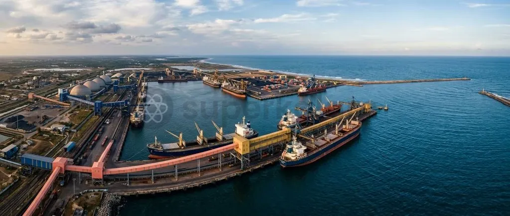
Paradip Port Authority has transformed eastern India's maritime economy. Deep-draft marine channels and automated bulk systems now anchor domestic mineral and energy supply chains.
The harbour operates as India's premier dry-bulk gateway. Its shift toward an autonomous landlord model unlocks national logistics efficiency under the Sagarmala Programme. Capital-intensive mechanisation and coastal industrialisation act as structural growth drivers rather than temporary volume spikes.
Why Paradip Port is in the Spotlight
Paradip Port Authority is India's highest cargo-handling Major Port. As of May 2025, official data from the Ministry of Ports, Shipping and Waterways confirms that Paradip Port handled a record 145.38 million metric tonnes (MMT) in FY 2023-24 and surpassed 150.41 MMT in FY 2024-25, supported by a total rated capacity of 289 MTPA.
This rapid expansion stems from berth automation, deep-draft navigation, and landlord governance models under the Major Port Authorities Act, 2021. For civil services aspirants, Paradip serves as a prime case study in lowering logistics costs, accelerating mineral evacuation, and supporting coastal heavy manufacturing under PM Gati Shakti.
Background: The Sagarmala Vision and East Coast Maritime Trade
The Sagarmala Programme is India's flagship initiative to reduce domestic supply chain costs through port modernisation and coastal industrial clustering. According to the Ministry of Ports, Shipping and Waterways, the Sagarmala Programme operates across five strategic pillars to harness India's 7,500-kilometre coastline:
- Port Modernisation & New Port Development: Expanding capacity, deepening drafts, and automating cargo handling.
- Port Connectivity Enhancement: Integrating maritime hubs with hinterland rail, highway, and inland waterway corridors.
- Port-Led Industrialisation: Developing industrial clusters, coastal economic zones, and petrochemical complexes near major harbours.
- Coastal Community Development: Promoting sustainable fisheries, skill training, and local maritime employment.
- Coastal Shipping & Inland Water Transport: Shifting bulk freight from congested rail and road networks to domestic waterways.
Historically, east coast ports struggled with shallow drafts, prolonged pre-berthing delays, and manual handling of bulk commodities like coal and iron ore. These bottlenecks pushed India's aggregate logistics expenditure to roughly 13–14% of GDP.
National maritime planning focused on upgrading eastern harbours. Modernising these ports created high-speed evacuation funnels for the mineral-rich hinterlands across central and eastern India.
Discuss with Superkalam
What are the five strategic pillars that define the operational framework of the Sagarmala Programme?
Ask NowInside Paradip Port: Strategic Geography and Core Operations
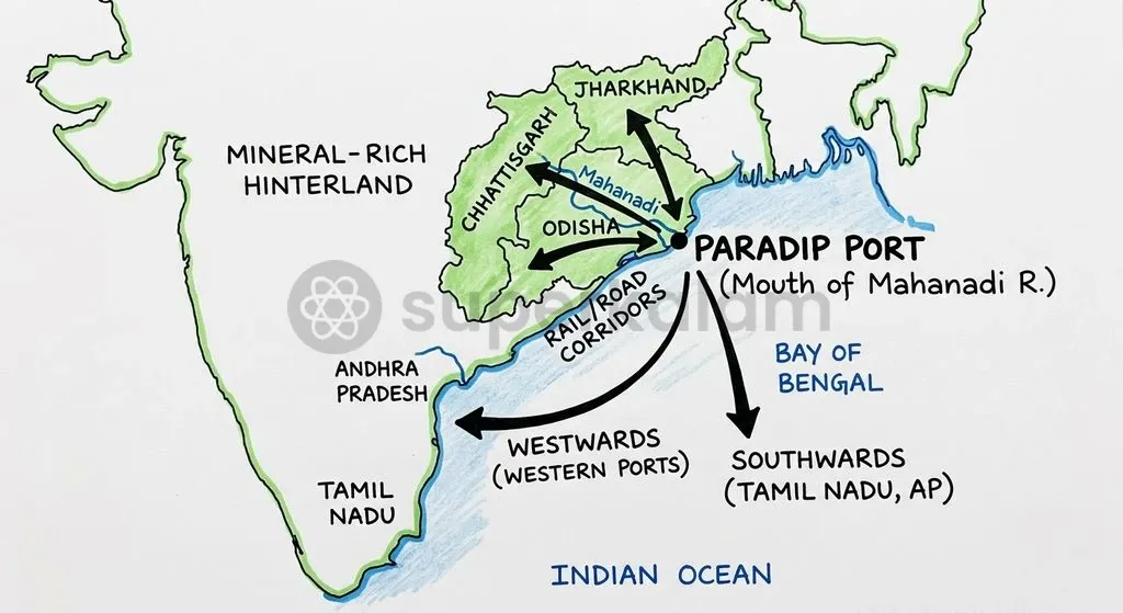
Paradip Port sits on the Bay of Bengal at the mouth of the Mahanadi River. Official master plans from the Paradip Port Authority place the harbour at latitude 20°15' N and longitude 86°40' E along the Odisha coast. This deep-water location makes Paradip the natural seaward gateway for mining belts across Odisha, Jharkhand, and Chhattisgarh.
| Parameter | Detail |
|---|---|
| Geographic Coordinates | 20°15' N, 86°40' E (Mahanadi River Confluence, Odisha) |
| Rated Operational Capacity | 289 MTPA |
| FY 2024-25 Throughput | 150.41 MMT (Rank 1 among Major Ports) |
| Navigational Draft Depth | 18.5 Metres (Deep-Draft Capable) |
| Primary Cargo Profile | Thermal Coal, Coking Coal, Iron Ore, Pellets, Crude |
| Core Coastal Role | Domestic Energy Security (Coastal Coal Shipping Hub) |
The port's core operations centre on dry bulk cargo and domestic energy logistics. According to the Ministry of Ports, Shipping and Waterways, Paradip is India's premier coastal shipping node, handling over 43.97 MMT of domestic thermal coal annually.
This dedicated coastal corridor moves coal from the Talcher and Ib Valley fields directly to thermal power utilities across Tamil Nadu, Andhra Pradesh, and Maharashtra.
The Road to 100% Berth Mechanisation by 2030: What Changes and Why
Paradip Port Authority plans to reach 100% berth mechanisation by 2030 to eliminate bulk handling delays. An 18.5-metre deep-draft capability enables the port to dock fully laden Capesize bulk carriers. The modernisation roadmap upgrades the harbour from a baseline of 80% mechanised berths to full automation across all operational terminals.
Conventional cargo handling causes fugitive dust pollution and prolonged vessel turnarounds. As outlined in the Paradip Port Project Review and Maritime India Vision 2030, the modernisation framework replaces conventional grabs with high-capacity ship loaders and unloaders, stacker-reclaimers, track hoppers, and enclosed conveyor systems. These sealed circuits transport iron ore and coal directly between rail wagons and ship holds without open-air exposure.
| Parameter | Conventional System | 100% Mechanised System |
|---|---|---|
| Handling Mechanism | Manual crane grabs | High-capacity ship loaders |
| Yard Conveyance | Open dump trucks | Enclosed conveyor circuits |
| Wagon Evacuation | Manual rake unloading | Automated track hoppers |
| Environmental Impact | Severe fugitive dust loss | Zero-dust enclosed handling |
| Vessel Turnaround Time | Prolonged (3-5 days) | Sub-48-hour discharge/load |
Mechanised loading cuts port turnaround times significantly. According to official performance reports from the Ministry of Ports, Shipping and Waterways, automated evacuation helped lower national average Major Port Turnaround Time (TRT) to 48.84 hours in FY 2025-26, down from 52.87 hours in FY 2021-22. Quicker turnarounds lower demurrage penalties for exporters and compress input costs for domestic manufacturers.
This capital transformation operates under the Landlord Port Model established by the Major Port Authorities Act, 2021 (Act No. 1 of 2021). The Paradip Port Authority retains public ownership of land and water basins while leasing terminal operations to private consortia under revenue-sharing PPP contracts. This model transfers operational and equipment financing risks to private operators, freeing the port authority to focus on conservancy, safety, and master planning.
Discuss with Superkalam
How does transitioning from a service port model to a landlord port model reallocate operational and financial risks between the State and private entities?
Ask NowPort-Led Industrialisation: Connecting Hinterland Mines to Coastal Manufacturing
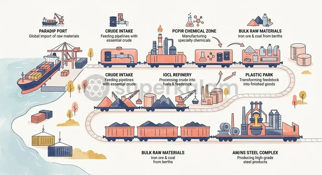
Paradip Port accelerates regional industrial growth by linking mineral-rich hinterlands directly to deep-water berths. Under Sagarmala and PM Gati Shakti, the port has leased over 769 acres of land to private enterprises, attracting over ₹8,700 crore in private industrial capital and generating more than 50 MMT of captive cargo traffic.
Industrial clusters around the harbour process raw minerals into high-value manufactured goods. Official data from the Department of Chemicals and Petrochemicals and the Government of Odisha confirms that Paradip anchors major facilities, including the Paradip Petroleum, Chemicals and Petrochemical Investment Region (PCPIR), the IOCL Refinery, the AM/NS India crude steel complex, and a Plastic Park. Coastal processing reduces inland freight expenses for both imported inputs and export cargo.
| Upstream Resource Hubs | Maritime Conversion Zone | Downstream Logistics |
|---|---|---|
| Talcher / Ib Valley Coal | Paradip PCPIR | Coastal Shipping to TN/AP |
| Keonjhar Iron Ore Belts | IOCL Refinery & Polymers | Export to Global Markets |
| Central Coking Coal Units | AM/NS Steel Facilities | Finished Coil & Fuel Rakes |
Internal evacuation corridors have also been upgraded to prevent dockside chokepoints. The port commissioned two dedicated road flyovers costing ₹150 crore and constructed broad-gauge double-line rail connectivity directly linked to mechanised terminal track hoppers.
Comparative Snapshot: Paradip Port vs Other Major Indian Ports
Major Indian ports differ in their cargo profiles, geography, and mechanical systems. While western ports handle large container flows, Paradip specialises in heavy dry bulk and domestic energy movements.
| Parameter | Paradip Port (Odisha) | Deendayal Port (Kandla, Gujarat) | JNPA (Navi Mumbai, Maharashtra) | Visakhapatnam Port (Andhra Pradesh) |
|---|---|---|---|---|
| Primary Coast | East Coast (Bay of Bengal) | West Coast (Gulf of Kutch) | West Coast (Arabian Sea) | East Coast (Bay of Bengal) |
| Dominant Cargo | Thermal Coal, Iron Ore, Crude Oil | Liquid Bulk, Dry Bulk, Fertiliser | Container Cargo, Manufactured Goods | Coking Coal, Iron Ore, Petroleum |
| Operational Model | Landlord Model (PPP Concessions) | Landlord Model (Trust to Authority transition) | Full Landlord Port (100% PPP Terminals) | Landlord Model (Mixed Berth Operations) |
| Navigational Draft | 18.5 Metres (Deep Draft) | ~14.5 to 15.5 Metres | ~15.0 to 16.0 Metres | ~16.5 to 18.1 Metres |
| Core Economic Function | Energy Security & Mineral Evacuation | Western Hinterland Bulk & Agri-trade | Containerised EXIM Trade Gateway | Industrial Hinterland Metal & Energy Hub |
Discuss with Superkalam
Compare the economic and environmental trade-offs between manual grab-based cargo handling and 100% enclosed berth mechanisation in bulk ports.
Ask NowKey Challenges: Environmental Risks, Evacuation Bottlenecks, and Global Trade Shocks
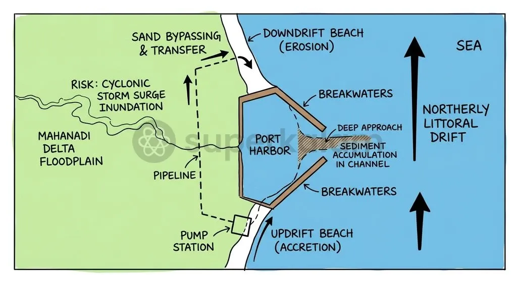
Paradip Port faces environmental risks from Bay of Bengal weather systems. Coastal hazard assessments by the National Institute of Oceanography show that the harbour sits on low deltaic land between 3.6 and 5.7 metres above sea level, exposing facilities to cyclonic storm surges and high gales.
Coastal sediment transport presents ongoing maintenance challenges. Studies by the Central Water and Power Research Station (CWPRS) reveal that northerly littoral drift carries large sand volumes across the harbour entrance, requiring annual maintenance dredging of over 2.4 million cubic metres and sand bypassing to prevent channel shoaling and northern beach erosion.
| Hazard Domain | Concrete Operational Risk Factor |
|---|---|
| Climate Risk | Deltaic elevations (3.6-5.7 m) vulnerable to severe cyclones |
| Sedimentation | Northerly littoral drift requiring >2.4M m³ annual dredging |
| Evacuation Lag | Capacity deficits on Cuttack-Paradip and Haridaspur lines |
| Market Volatility | Global decarbonisation policies impacting thermal coal demand |
Inland connectivity creates further constraints during peak traffic periods. According to the Maritime India Vision 2030 Hinterland Logistics Report, rail corridors along the Cuttack-Paradip and Haridaspur-Paradip rail lines face network congestion and intermittent rolling stock deficits. These rail bottlenecks risk capping clearance speeds despite rapid ship-to-shore mechanical handling.
Way Forward: Building a Resilient, Green, and Digitised Maritime Hub
Sustainable growth requires combining capacity expansion with environmental safeguards. Under the 'Harit Sagar' Green Port Guidelines from the Ministry of Ports, Shipping and Waterways, Paradip Port has built a 10 MW solar power plant and planted a green belt of over one million trees to curb fugitive dust emissions.
Longer-term expansion is guided by the 'Paradip Port 2.0' roadmap, which targets cargo handling capacity of over 500 MTPA by 2047. Key priorities in this strategy include:
- Western Dock Deepening: Deepening inner docks to accommodate mega-bulk vessels across all operational berths.
- Clean Fuel Terminals: Developing dedicated green ammonia and green hydrogen handling berths to support the global energy transition.
- Regional Shipbuilding Cluster: Setting up a maritime shipbuilding, fabrication, and vessel repair ecosystem north of the Mahanadi River in Kendrapara district.
- Digital Port Ecosystem: Integrating the National Logistics Portal (Marine) and automated vessel traffic management systems to eliminate manual clearances.
Automated cargo systems, improved rail connectivity, and green port standards position Paradip Port as a resilient driver of India's blue economy.
Discuss with Superkalam
How can maritime planners design multi-modal evacuation corridors to prevent dockside congestion as deep-draft ports scale beyond 250 MTPA capacity?
Ask NowKey Takeaways
- Paradip Port Authority is India's leading Major Port by volume, handling 145.38 MMT in FY 2023-24 and over 150.41 MMT in FY 2024-25, supported by a rated capacity of 289 MTPA.
- The port plans to transition from its baseline of 80% mechanisation to 100% berth mechanisation by 2030, deploying rapid enclosed conveyors and automated ship loaders to compress vessel turnaround times.
- Operating under the statutory Major Port Authorities Act, 2021, Paradip follows the Landlord Port Model, leasing operational berths to private concessionaires while retaining marine conservancy and land ownership.
- Paradip acts as India's primary domestic energy conduit, shipping over 43.97 MMT of coastal thermal coal annually to power utilities in southern and western states.
- High siltation from northerly littoral drift demands over 2.4 million cubic metres of annual maintenance dredging, while low deltaic elevations of 3.6 to 5.7 metres create vulnerability to cyclonic storm surges.
- Long-term development under the 'Paradip Port 2.0' master plan targets 500 MTPA capacity by 2047, integrating dedicated green hydrogen berths and a major shipbuilding cluster in Kendrapara district.
Mains Question
The transition towards the Landlord Port Model under the Major Port Authorities Act, 2021, coupled with 100% berth mechanisation, is pivotal for transforming India's dry-bulk maritime logistics. Examine in the context of Paradip Port. (10 Marks)
Evaluate NowMains Question
'Port-led industrialisation under the Sagarmala Programme serves as a critical bridge between mineral-rich hinterlands and coastal manufacturing hubs.' Discuss with reference to industrial clustering and evacuation infrastructure at Paradip Port. (15 Marks)
Evaluate NowPractice MCQs
QUESTION 1
Consider the following statements regarding the strategic and operational profile of Paradip Port:
- It is situated on the Bay of Bengal at the confluence of the Mahanadi River along the Odisha coast.
- It possesses an 18.5-metre deep-draft capability allowing it to dock fully laden Capesize bulk carriers.
- It acts as a dedicated coastal shipping hub moving thermal coal from the Talcher and Ib Valley fields to power utilities in southern and western India. Which of the statements given above are correct?
QUESTION 2
With reference to the Landlord Port Model institutionalised under the Major Port Authorities Act, 2021, consider the following statements:
- The Port Authority transfers full public ownership of port land and water basins to private concessionaires.
- Terminal operations and cargo handling are leased to private consortia under revenue-sharing public-private partnership (PPP) contracts.
- The Port Authority retains functions related to conservancy, safety, and port master planning. Which of the statements given above is/are correct?
QUESTION 3
Consider the following strategic components:
- Port Modernisation & New Port Development
- Port Connectivity Enhancement
- Port-Led Industrialisation
- Coastal Community Development
- Coastal Shipping & Inland Water Transport How many of the above are official strategic pillars of the Sagarmala Programme as outlined by the Ministry of Ports, Shipping and Waterways?
QUESTION 4
Consider the following statements regarding berth mechanisation and cargo evacuation infrastructure at Paradip Port:
- The modernisation roadmap targets 100% berth mechanisation by 2030, upgrading from a baseline of 80% mechanised berths.
- Enclosed conveyor circuits and automated track hoppers replace manual grabs and open dump trucks to eliminate fugitive dust emissions.
- Dedicated double-line broad-gauge rail links and road flyovers connect directly to mechanised terminal track hoppers to prevent dockside bottlenecks. Which of the statements given above is/are correct?
QUESTION 5
Which of the following best describes the primary dry-bulk cargo profile that drives the operational throughput of Paradip Port?