Nepal Flash Floods: Transboundary Disaster Risks in India
Upstream cloudbursts and massive Himalayan siltation continue to test India-Nepal transboundary river governance across vulnerable downstream floodplains.
Sep, 2026
•10 min read
Overview
Transboundary flash floods originating in Nepal pose recurring disaster management challenges for India, demanding a shift from structural flood-control engineering towards integrated watershed management and real-time hydrological data exchange across the shared Himalayan river basins. Rapid orographic precipitation, cloudburst events, and high sediment yields in upper catchments routinely overwhelm downstream river channels across the Indo-Gangetic plains. As of July 2026, institutional mechanisms between India and Nepal continue to grapple with severe riverbed aggradation and embankment vulnerabilities in downstream regions like Bihar and Eastern Uttar Pradesh. Enhancing cross-border multi-hazard early warning systems under global frameworks remains central to mitigating economic losses and safeguarding vulnerable riparian communities.
Why in the News?
The Central Water Commission and Nepal's Department of Hydrology and Meteorology coordinate operational telemetry to manage transboundary monsoon surges across northern river basins. Recurrent flash floods in the Himalayan foothills highlight the persistent vulnerability of downstream populations in northern Bihar and eastern Uttar Pradesh to upstream cloudbursts and debris flows. As of July 2026, high discharge rates across the Saptakoshi, Gandak, and Ghaghara river systems have renewed focus on bilateral water governance and disaster preparedness. Addressing these transboundary risks remains integral to achieving the disaster-resilience targets established under the Sendai Framework for Disaster Risk Reduction (2015–2030).
Understanding Flash Floods in the Fragile Himalayan Ecosystem
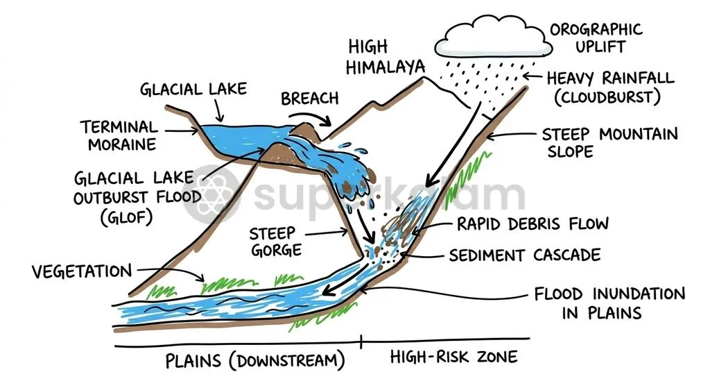
Himalayan flash floods are sudden, high-velocity surges driven by intense precipitation, steep topographic gradients, and the fragile geological structure of young fold mountains. According to the India Meteorological Department and ICIMOD, orographic lifting occurs when moisture-laden South Asian summer monsoon air masses strike the steep barriers of the Mahabharat Lekh and the Great Himalayan Range. This rapid mechanical ascent triggers intense convective precipitation, frequently exceeding 100 mm per hour in localised upper catchments.
High-altitude catchments also face acute risks from Glacial Lake Outburst Floods (GLOFs) and Landslide Dam Outburst Floods (LDOFs). A Glacial Lake Outburst Flood occurs when a moraine or ice dam containing a glacial lake suddenly fails, releasing massive volumes of impounded water and debris downstream. The transboundary Bhote Koshi and Trishuli catchments are particularly vulnerable to these events, which generate hyper-concentrated debris flows that choke downstream drainage channels, according to the National Disaster Risk Reduction and Management Authority of Nepal.
| Hydrological Hazard | Primary Physical Trigger | Upstream Impact in Nepal | Downstream Manifestation in India |
|---|---|---|---|
| Orographic Flash Flood | Monsoon air masses lifting over steep mountain barriers | Torrential runoff, severe hillslope erosion, and bank scouring | Rapid channel inundation across low-gradient alluvial floodplains |
| Cloudburst Surge | Extreme convective precipitation (>100 mm/hour) | Localised flash floods, massive gully formation, and hillslope failures | Sudden discharge peaks reaching downstream barrages within hours |
| Glacial Lake Outburst Flood (GLOF) | Moraine dam failure due to ice avalanches or hydrostatic pressure | Catastrophic debris flow, destructive hydraulic wave fronts | Heavy silt deposition, barrage gate choking, and sudden backwater surges |
| Landslide Dam Outburst Flood (LDOF) | Breaching of temporary debris dams across river gorges | Upstream lake formation followed by catastrophic flash floods | High sediment surges altering channel morphology and breaching afflux bunds |
Discuss with Superkalam
Which specific mountain ranges cause the rapid orographic lifting that triggers intense Himalayan convective rainfall?
Ask NowTransboundary Hydrology: How Floods in Nepal Impact Northern India
Transboundary flood hazards travel primarily through four major sub-basins of the Ganga River system: the Mahakali (Sharda), Karnali (Ghaghara), Narayani (Gandak), and Saptakoshi (Kosi), according to the Central Water Commission. These river networks drain massive Himalayan catchments in Nepal before debouching into the flat, low-gradient alluvial plains of northern India.
The Saptakoshi river system converges seven Himalayan tributaries—the Sun Koshi, Arun, Tamur, Dudh Koshi, Bhote Koshi, Tama Koshi, and Indrawati—at Tribeni in Nepal before exiting the mountain gorge at Chatra, as documented by the Joint Project Office for Saptakoshi Sun Kosi Investigation. Entering the North Bihar plains, the Kosi transitions abruptly from a steep mountain slope to an alluvial plain with a gradient of less than 1:10,000, drastically reducing flow velocity and triggering heavy sediment deposition.
The Gandak (Narayani) river system is fed by high-altitude catchments including the Trishuli and Kali Gandaki. The river enters the Indian plains at the Valmikinagar Barrage in West Champaran, Bihar, generating high downstream inundation risks across the low-lying floodplains of Gopalganj, Saran, and Muzaffarpur.
The Ghaghara (Karnali) river represents the largest tributary of the Ganga by volume, draining western Nepal and delivering heavy monsoon discharges directly into eastern Uttar Pradesh. These excessive transboundary flows create extensive waterlogging and severe inundation across downstream districts, particularly Bahraich, Shravasti, Gonda, and Balrampur, according to Central Water Commission basin assessment studies.
Discuss with Superkalam
How does an abrupt change in river slope from mountain gorge to alluvial plain cause heavy riverbed siltation?
Ask NowStructural Traps and Siltation Dynamics in Downstream Plains
North Bihar faces extreme vulnerability to flooding, with approximately 73.06% of its geographical area—covering 16.5 million hectares across the state—officially classified as flood-prone by the Bihar Disaster Management Department. This vulnerable expanse accounts for roughly 16.5% of India's total flood-prone area, driven by high transboundary runoff and massive sediment transport.
The Kosi River basin exhibits the highest sediment yield among Himalayan river systems, carrying an annual suspended sediment load of nearly 100 million cubic metres into the low-gradient North Bihar plains, according to the Ganga Flood Control Commission. When these sediment-laden flows leave the steep Himalayan gorges, the sudden reduction in hydraulic gradient forces the river to shed its bedload directly onto the riverbed.
Structural engineering interventions have inadvertently exacerbated this sedimentation crisis:
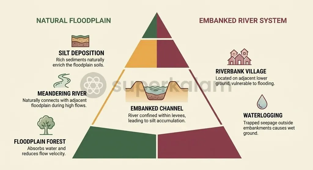
- Riverbed Aggradation: Continuous earthen embankments jacket the river, preventing lateral sediment dispersal across natural floodplains and raising riverbeds several feet above the surrounding countryside.
- Loss of Drainage Gradients: Elevated river channels obstruct natural drainage paths of local tributaries, creating severe waterlogging (chaurs) outside embankment walls.
- Lateral Channel Avulsion: Excessive bedload deposition forces river channels to braid and swing laterally, applying intense hydraulic pressure on afflux bunds.
- Catastrophic Embankment Failure: The 18 August 2008 breach at Kusaha in Sunsari district, Nepal (12.9 km upstream of the Birpur Barrage), occurred at a discharge of ~1.44 lakh cusecs—well below the barrage design capacity of 9.5 lakh cusecs.
The 2008 Kusaha breach caused a massive eastward avulsion exceeding 100 km, inundating over 3.3 million people across Supaul, Madhepura, Saharsa, Araria, and Purnia districts and claiming over 500 lives, as recorded in post-disaster assessments by the National Disaster Management Authority.
Discuss with Superkalam
If telemetry stations in upstream Nepal record a cloudburst, how can downstream administrations in Bihar and UP optimise the available lead time?
Ask NowExisting India-Nepal Bilateral Mechanisms for Flood Management
Bilateral water governance between India and Nepal operates through a formal three-tier institutional mechanism established during 2008–2009 to oversee transboundary river management. This structured framework coordinates river monitoring, water resource development, and operational flood control, as detailed in Central Water Commission annual reports.
The three-tier institutional framework functions across distinct operational levels:
- Joint Committee on Water Resources (JCWR): The apex bilateral body headed by the Water Resources Secretaries of both nations, responsible for strategic policy decisions, bilateral treaties, and overall water cooperation.
- Joint Standing Technical Committee (JSTC): A technical coordinating committee that evaluates engineering feasibility, reviews project reports, and directs technical sub-committees.
- Joint Committee on Inundation and Flood Management (JCIFM): The operational body co-chaired by the Member, Ganga Flood Control Commission (GFCC), Patna, and the Director General, Department of Water Resources and Irrigation (DWRI), Nepal, tasked with executing flood-control works and field inspections.
Transboundary water cooperation on the western border is governed separately by the Mahakali Treaty of February 1996, which regulates water sharing and infrastructure on the Mahakali River (known as the Sharda in India), including the Sarada Barrage, Tanakpur Barrage, and the proposed Pancheshwar Multipurpose Project.
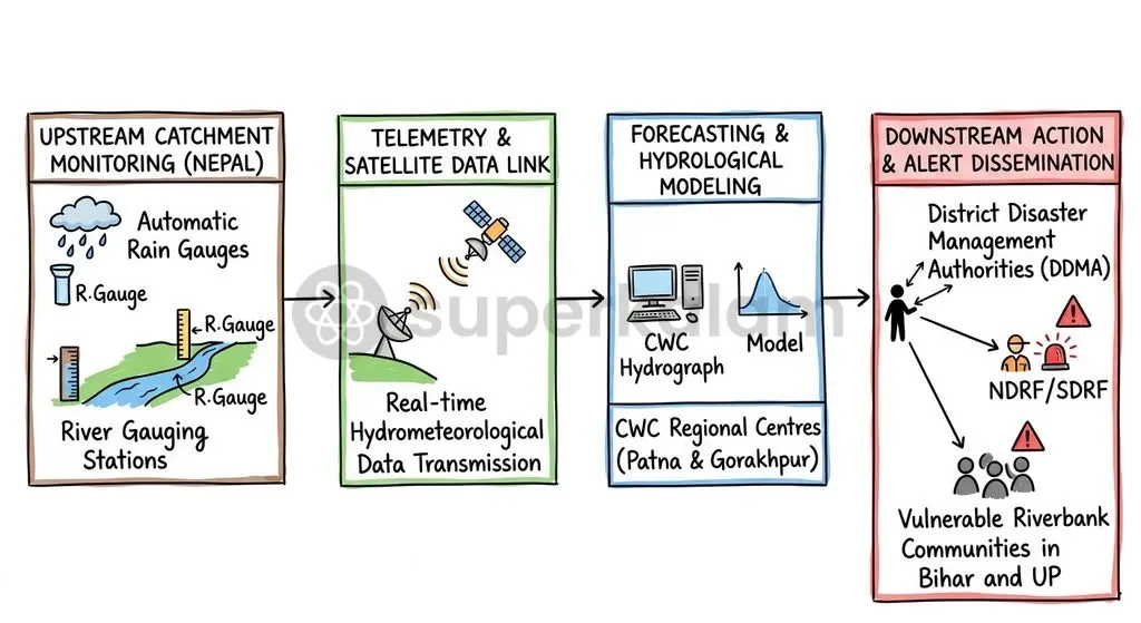
To maintain real-time flood preparedness, Nepal's Department of Hydrology and Meteorology and India's Central Water Commission operate a bilateral network of telemetry and hydro-meteorological stations across Nepalese catchments. These stations transmit real-time water level and rainfall telemetry to Central Water Commission flood forecasting divisions in Patna and Gorakhpur, providing critical lead time for downstream evacuation.
Discuss with Superkalam
Why did the 2008 Kusaha embankment breach occur at a flow rate far below the barrage's maximum design capacity?
Ask NowKey Bottlenecks in Cross-Border Early Warning and Infrastructure
Bilateral flood mitigation efforts face significant technical, institutional, and geopolitical bottlenecks that impede long-term disaster resilience across the shared river basins. A major structural challenge involves stalled negotiations over large-scale storage reservoirs designed to moderate peak monsoon discharges.
Negotiations over the proposed 269-metre-high Sapta Kosi High Dam Multipurpose Project at Barakshetra and the Sunkoshi Storage-cum-Diversion Scheme remain deadlocked, according to joint communiques from the Ministry of Jal Shakti and Nepal's Ministry of Energy, Water Resources and Irrigation. Disagreements over land submergence compensation, upstream ecological impacts in Nepal, and water-allocation rights continue to stall project execution.
Operational early warning systems also encounter critical bottlenecks:
- Telemetry Data Latency: High-altitude weather stations in rugged Himalayan terrain suffer frequent communication dropouts during extreme cloudburst events, delaying real-time flood warnings.
- Inadequate Downstream Lead Time: Short travel distances between the Himalayan foothills and downstream plains leave disaster management authorities in Bihar and Uttar Pradesh with minimal reaction windows.
- Embankment Maintenance Jurisdictions: Indian water resource engineers face administrative and logistical delays when executing emergency embankment reinforcement within Nepalese territory.
- Sediment Flushing Deficits: Downstream barrages lack adequate sediment-bypass mechanisms, causing severe silt deposition that impairs barrage gate operations during high monsoon surges.
Way Forward: Regional Water Governance and Resilient Infrastructure
Disaster risk reduction in transboundary basins requires operationalising Priority 4 of the Sendai Framework for Disaster Risk Reduction (2015–2030), which mandates enhancing disaster preparedness and building back better. As outlined by the United Nations Office for Disaster Risk Reduction, effective transboundary risk management depends on multi-hazard early warning systems (MHEWS) supported by cross-border institutional cooperation.
Under the Bihar Disaster Risk Reduction Roadmap (2015–2030), the State Government has operationalised community-centric early warning dissemination using the Common Alerting Protocol (CAP) and the SACHET portal, integrated with deployed State Disaster Response Force (SDRF) battalions across vulnerable border divisions. Expanding this framework into an end-to-end transboundary system requires strategic structural and non-structural interventions:
- Expanded Upper-Catchment Radar Telemetry: Install high-frequency X-band Doppler weather radars and automated hydrological stations across upper catchments in Nepal to capture real-time cloudburst dynamics.
- Nature-Based Catchment Restoration: Implement catchment-wide afforestation, soil conservation, and check-dam construction in the Mahabharat Lekh and Siwalik ranges to reduce topsoil erosion and downstream sediment yield.
- Non-Structural Floodplain Zoning: Enforce strict coastal and riverine floodplain zoning in downstream plains to regulate permanent settlement within active river channels and preserve natural flood retention basins.
- Joint Disaster Preparedness Drills: Institutionalise coordinated mock drills between India's National Disaster Response Force (NDRF), Bihar SDRF, and Nepal's armed police forces to streamline emergency rescue operations.
Discuss with Superkalam
How can India and Nepal restructure bilateral water management to transition from reactive embankment building to watershed-level resilience?
Ask NowKey Takeaways
- Himalayan flash floods are driven by rapid orographic lifting, cloudburst precipitation (>100 mm/hour), and hyper-concentrated GLOF/LDOF debris flows across steep mountain gradients.
- Transboundary runoff flows through four major Ganga sub-basins: the Mahakali (Sharda), Karnali (Ghaghara), Narayani (Gandak), and Saptakoshi (Kosi).
- High siltation presents an acute structural challenge, with the Kosi basin transporting nearly 100 million cubic metres of suspended sediment annually, driving extensive riverbed aggradation.
- North Bihar remains exceptionally vulnerable, with 73.06% of its geographical area classified as flood-prone, accounting for roughly 16.5% of India's total flood-prone area.
- Bilateral flood governance is structured under a three-tier institutional mechanism: the apex Joint Committee on Water Resources (JCWR), the Joint Standing Technical Committee (JSTC), and the operational Joint Committee on Inundation and Flood Management (JCIFM).
- Enhancing transboundary disaster resilience aligns with Priority 4 of the Sendai Framework (2015–2030), requiring integrated early warning systems, real-time telemetry, and resilient watershed management.
Mains Question
"Structural engineering interventions like continuous embankments have inadvertently transformed seasonal inundation into chronic riverbed aggradation and waterlogging in the North Bihar plains." Examine. (10 Marks)
Evaluate NowMains Question
The institutional mechanisms established under the India-Nepal bilateral framework face complex hydrometeorological and structural challenges in managing transboundary disasters. In this context, critically evaluate the efficacy of existing cross-border flood governance. (15 Marks)
Evaluate NowPractice MCQs
QUESTION 1
With reference to the physical triggers of transboundary flash floods in the Himalayan ecosystem, consider the following statements:
- Orographic lifting triggers convective precipitation exceeding 100 mm per hour when moisture-laden monsoon air masses hit the Mahabharat Lekh and Great Himalayan Range.
- Glacial Lake Outburst Floods (GLOFs) occur primarily due to the breaching of artificial concrete afflux bunds.
- Landslide Dam Outburst Floods (LDOFs) lead to high sediment surges capable of altering downstream channel morphology.
Which of the statements given above are correct?
QUESTION 2
Consider the following statements regarding the transboundary river systems originating in Nepal:
- The Saptakoshi river system converges seven Himalayan tributaries at Tribeni before exiting the mountain gorge at Chatra.
- The Ghaghara (Karnali) river is the largest tributary of the Ganga by volume.
- The Gandak (Narayani) river debouches into the Indian plains at the Valmikinagar Barrage in Bihar.
Which of the statements given above are correct?
QUESTION 3
Consider the following statements regarding the structural and morphological dynamics of floodplains in North Bihar:
- North Bihar accounts for approximately 16.5% of India's total flood-prone area.
- The Kosi River basin carries an annual suspended sediment load of nearly 100 million cubic metres into the plains.
- Continuous earthen embankments promote lateral sediment dispersal and effectively prevent riverbed aggradation.
Which of the statements given above is/are correct?
QUESTION 4
With reference to the India-Nepal three-tier bilateral institutional mechanism for water resources, which body functions as the apex authority headed at the Secretary level?
QUESTION 5
With reference to transboundary water agreements between India and Nepal, consider the following statements:
- The Mahakali Treaty of 1996 regulates water sharing on the river known as the Sharda in India.
- The proposed Pancheshwar Multipurpose Project is governed under the framework of the Mahakali Treaty.
Which of the statements given above is/are correct?