National Water Data Policy: Sujalam Bharat & India's Water Governance
Bridging federal hydro-data silos through Sujalam Bharat DPI is crucial for India's river basin management, disaster mitigation, and real-time governance.
Aug, 2026
•10 min read
Overview
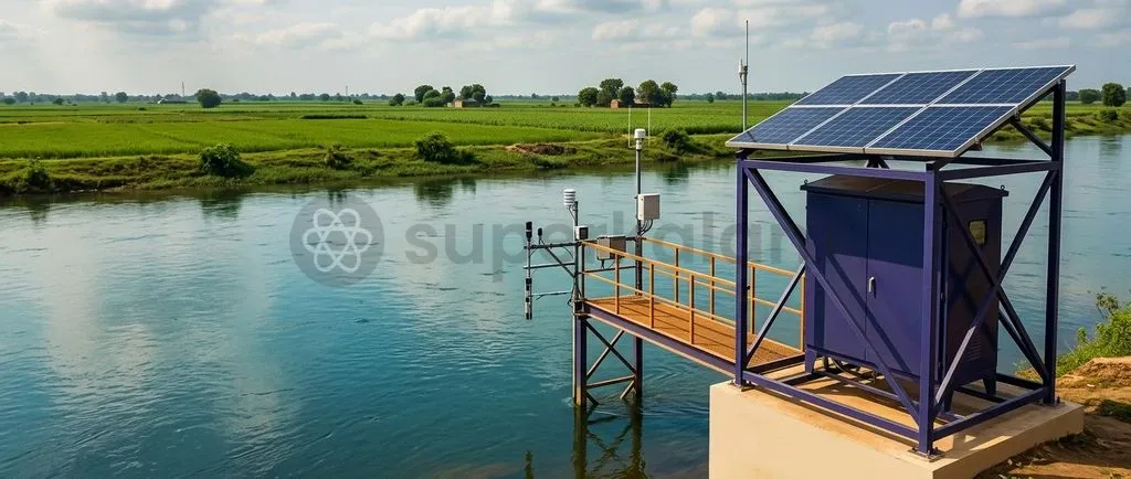
The Ministry of Jal Shakti has introduced the Policy on Data Sharing, Interoperability and Stakeholder Access under the Sujalam Bharat Digital Public Infrastructure to transition India from fragmented hydro-meteorological silos toward a unified digital water architecture. This framework links rural drinking water management with national geospatial systems like the PM GatiShakti National Master Plan.
As of August 2026, unique Sujal Gaon IDs cover 75% of rural habitations under Jal Jeevan Mission 2.0 digital monitoring. By standardising hydrological metrics across central and state bodies, the initiative establishes an evidence-based foundation for national water security.
Why is the National Water Data Policy in the News?
India's water governance has long contended with institutional fragmentation across state and central bodies. The new policy establishes technical standards to reconcile state-level administration with macro-level basin planning:
- Policy notification: The Ministry of Jal Shakti issued the Policy on Data Sharing, Interoperability and Stakeholder Access under the Sujalam Bharat Digital Public Infrastructure on 20 August 2026.
- Technical design: Developed with technical assistance from the Bhaskaracharya National Institute for Space Applications and Geo-informatics (BISAG-N), the policy provides a blueprint for secure data exchange across water institutions.
- Geospatial integration: As of August 2026, digital governance has accelerated through the allocation of unique Sujal Gaon IDs to 1,267,808 rural habitations, covering 75% of the 1,696,213 total habitations in the country. This digital infrastructure connects local scheme registries directly to the PM GatiShakti National Master Plan for real-time asset validation.
Discuss with Superkalam
Explain the operational division of responsibilities between the Central Water Commission (CWC) and the Central Ground Water Board (CGWB) in monitoring India's water resources.
Ask NowThe Background: Why India's Water Data Remains Siloed and Inaccessible
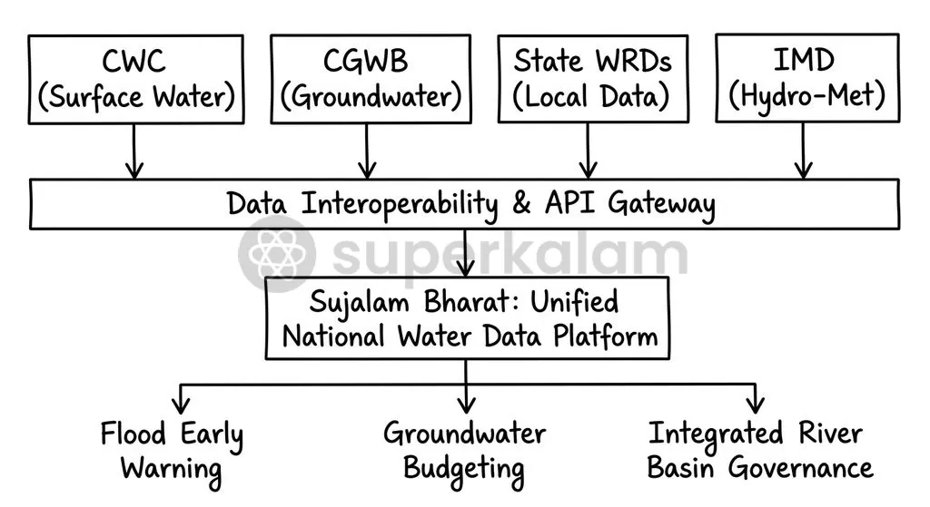
India's water administration has historically operated across departmental silos divided between central and state agencies. The Central Water Commission (CWC) monitors surface water flows and national river telemetry networks. Concurrently, the Central Ground Water Board (CGWB) oversees groundwater exploration and the National Aquifer Mapping and Management (NAQUIM) programme.
State government departments independently track local canals, minor irrigation tanks, and municipal water supplies. These uncoordinated efforts cause several structural problems:
- Inconsistent sensor calibration across state jurisdictions.
- Proprietary telemetry protocols that prevent direct software integration.
- Divergent data collection schedules that misalign water accounting.
National security considerations also introduce accessibility barriers. Hydro-meteorological datasets in transboundary river basins such as the Indus and Brahmaputra remain classified under government dissemination guidelines, restricting public access to critical hydrological models.
What is the National Water Data Sharing and Interoperability Policy?
The Sujalam Bharat Digital Public Infrastructure establishes a federated data architecture using common identifiers, standardised metadata, and secure digital application programming interfaces. This framework transitions the water sector away from isolated data spreadsheets into a machine-readable digital ecosystem.
Under this model, state and central departments retain administrative ownership of their data while exposing standardised endpoints for national aggregation. This structure prevents centralised data monopolisation while enforcing uniform technical standards.
| Governance Dimension | Legacy Water Data Architecture | Sujalam Bharat Interoperable Framework |
|---|---|---|
| Data Custodianship | Fragmented across isolated central and state agencies | Federated data architecture with common identifiers |
| Metadata Standards | Uncoordinated, non-standardised formats | Standardised metadata schemas and open APIs |
| Geospatial Integration | Disconnected local records | Unified with PM GatiShakti National Master Plan |
| Scheme Tracking | Manual, periodic paper reports | Real-time tracking via unique Sujal Gaon IDs |
| Public Accessibility | Restricted or siloed departmental portals | Secure, tiered stakeholder access |
Discuss with Superkalam
Analyze how the federated data architecture under Sujalam Bharat seeks to resolve the tension between state data ownership and national basin planning.
Ask NowKey Pillars and Architecture of the Water Data Interoperability Framework
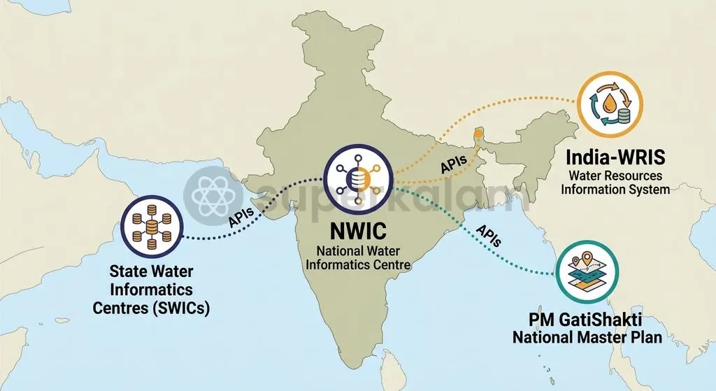
The National Water Informatics Centre is the single-window central repository for nation-wide water resources data across India. Established on 28 March 2018 as a subordinate office under the Ministry of Jal Shakti, the National Water Informatics Centre (NWIC) maintains national hydrological repositories.
NWIC manages two foundational digital platforms:
- India Water Resources Information System (India-WRIS): A web-enabled GIS portal providing comprehensive spatial layers on surface water bodies, river gauges, reservoirs, and soil moisture.
- Water Information Management System (WIMS): A cloud-based platform designed to ingest, validate, and process high-frequency hydro-meteorological telemetry datasets.
Under the National Hydrology Project (NHP), the Ministry of Jal Shakti has mandated the creation of State Water Informatics Centres across all States and Union Territories. These state centres mirror NWIC architecture, ensuring real-time synchronisation between regional telemetry sensors and the national repository.
The platform also includes the Jal Dharohar GIS sub-portal within India-WRIS. This sub-portal integrates geo-tagged inventories from the First Census of Water Bodies, Atal Bhujal Yojana, and Minor Irrigation Statistics into an interoperable spatial database.
Discuss with Superkalam
Evaluate whether classifying transboundary river basin data on national security grounds undermines effective domestic flood forecasting and disaster mitigation.
Ask NowWhy Unified Water Data Matters: From Flood Forecasting to Farm Resilience
Real-time hydrological integration empowers disaster management authorities and agricultural planners to mitigate climate shocks across river basins. Seamless data exchange supports multiple key operational domains:
- Disaster mitigation and flood alerts: The Central Water Commission utilises these data streams through its Flood Watch India mobile application, providing real-time flood forecasts and basin alerts.
- Agricultural water budgeting: Interoperable groundwater data generated by the Central Ground Water Board under NAQUIM enables precision irrigation and crop-water budgeting.
- Participatory local planning: Community-level planning is operationalised through the Atal Bhujal Yojana. The programme trains Village Water and Sanitation Committees to measure local water tables, generating bottom-up data for participatory Water Security Plans.
Discuss with Superkalam
Design an institutional roadmap to incentivize riparian states to share real-time reservoir and canal telemetry data through State Water Informatics Centres.
Ask NowFederal and Institutional Roadblocks in Sharing Water Data Across States
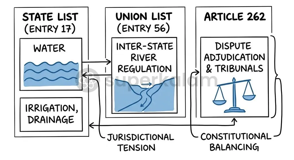
The constitutional distribution of legislative powers creates structural friction between state water autonomy and central river basin data management. The Constitution distributes water-related legislative subjects across two lists:
- State List (Entry 17, List II): Grants states legislative authority over water supplies, irrigation, canals, drainage, embankments, water storage, and water power, subject to Entry 56 of List I.
- Union List (Entry 56, List I): Empowers Parliament to regulate and develop inter-State rivers and river valleys to the extent declared by law to be expedient in the public interest.
- Article 262: Authorises Parliament to provide for the adjudication of disputes relating to the use, distribution, or control of inter-State waters.
Because water rights are contentious, riparian states often treat reservoir levels and discharge data as proprietary strategic assets during inter-State river disputes. This political hesitation undermines automated data exchanges across river basins.
Technical mismatches exacerbate these federal frictions. Variations in sensor maintenance, lack of technical staff at local levels, and divergent telemetry formats continue to stall real-time integration.
How Other Nations Manage Open Hydrological Data
International water governance models demonstrate how statutory mandates and common metadata standards overcome federal data-sharing deadlocks.
| Jurisdiction | Governing Legal Framework | Nodal Institution | Technical & Open Data Mechanism |
|---|---|---|---|
| Australia | Part 7, Water Act 2007 & Water Regulations 2008 | Bureau of Meteorology | Statutory mandate requiring water utilities to deliver standardised hydrological data |
| United States | Open Water Data Initiative (OWDI) | US Geological Survey (USGS) | National Water Information System utilising OGC WaterML2 encoding standards |
| European Union | Water Framework Directive (2000/60/EC) & INSPIRE Directive (2007/2/EC) | European Environment Agency | Water Information System for Europe enforcing mandatory cross-border river basin reporting |
| India | Sujalam Bharat Policy & National Hydrology Project | National Water Informatics Centre (NWIC) | Federated India-WRIS portal with automated APIs and Sujal Gaon ID mapping |
Way Forward: Creating a Collaborative, Open-Access National Hydrology Framework
Establishing an interoperable national water data ecosystem requires aligning state technical infrastructure with statutory data-sharing mandates.
- Statutory Backing for Data Sharing: India should introduce statutory obligations for inter-state hydrological data sharing, drawing inspiration from Part 7 of Australia's Water Act 2007.
- Universalising State Water Informatics Centres: State governments must accelerate the operationalisation of State Water Informatics Centres to ensure continuous telemetry streaming into the India-WRIS framework.
- Harmonising Open API Protocols: Standardising open geospatial application programming interfaces will eliminate proprietary software lock-ins across regional water boards.
- Decentralising Citizen Hydrology: Expanding participatory groundwater monitoring through Village Water and Sanitation Committees under Atal Bhujal Yojana ensures robust local data validation for Water Security Plans.
Key Takeaways
- The Ministry of Jal Shakti released the Policy on Data Sharing, Interoperability and Stakeholder Access on 20 August 2026 under the Sujalam Bharat Digital Public Infrastructure.
- As of August 2026, unique Sujal Gaon IDs cover 75% (1,267,808) of India's 1,696,213 rural habitations, integrating local water schemes with the PM GatiShakti platform.
- The National Water Informatics Centre (NWIC), established on 28 March 2018, manages national hydrological datasets through the India-WRIS and WIMS portals.
- Legislative authority over water is governed by Entry 17 of the State List, subject to parliamentary regulation under Entry 56 of the Union List and dispute adjudication under Article 262.
- Institutional silos, sensor calibration disparities, and transboundary data classification under national security guidelines remain critical operational challenges.
Mains Question
"The transition from fragmented departmental silos to a federated digital water architecture under the Sujalam Bharat Digital Public Infrastructure faces both constitutional and institutional challenges." Critically examine the structural impediments to inter-state water data sharing in India. (15 Marks)
Evaluate NowMains Question
Evaluate the role of the National Water Informatics Centre (NWIC) and associated digital platforms in strengthening evidence-based water governance and disaster preparedness in India. (10 Marks)
Evaluate NowPractice MCQs
QUESTION 1
With reference to the Sujalam Bharat Digital Public Infrastructure and national water governance, consider the following statements:
- The Sujalam Bharat framework adopts a federated data architecture where administrative ownership of data is retained by respective state and central departments.
- The National Water Informatics Centre (NWIC) functions as a subordinate office under the Ministry of Jal Shakti to maintain national hydrological repositories.
- The Jal Dharohar GIS sub-portal integrates data from the First Census of Water Bodies and Atal Bhujal Yojana into India-WRIS.
Which of the statements given above are correct?
QUESTION 2
Consider the following statements regarding the constitutional division of powers concerning water resources in India:
- Entry 17 of the State List confers legislative authority over water supplies, irrigation, and water storage, subject to Entry 56 of the Union List.
- Entry 56 of the Union List empowers Parliament to regulate and develop inter-State rivers and river valleys to the extent declared by law to be expedient in the public interest.
- Article 262 empowers the Supreme Court to directly take original jurisdiction over all inter-State river water disputes without Parliamentary enactment.
Which of the statements given above is/are correct?
QUESTION 3
With reference to digital water governance platforms in India, consider the following statements:
- The Water Information Management System (WIMS) is a cloud-based platform designed to ingest and validate high-frequency hydro-meteorological telemetry datasets.
- Unique Sujal Gaon IDs are allocated under Jal Jeevan Mission digital monitoring and connect directly to the PM GatiShakti National Master Plan.
- The Flood Watch India mobile application is an initiative of the Central Ground Water Board (CGWB) for monitoring aquifer levels.
Which of the statements given above is/are correct?
QUESTION 4
Consider the following statements regarding the institutional framework of India's National Water Data Policy:
- Technical design and assistance for the data sharing policy under Sujalam Bharat were provided by the Bhaskaracharya National Institute for Space Applications and Geo-informatics (BISAG-N).
- Under the National Hydrology Project, State Water Informatics Centres are established across States and Union Territories to mirror NWIC architecture.
Which of the statements given above is/are correct?
QUESTION 5
In the context of participatory water governance and agricultural water planning, which programme operationalises community-level Water Security Plans through Village Water and Sanitation Committees?