Kulsi Multipurpose Project: River Dolphins and Sixth Schedule Resistance
When interstate hydropower collides with Sixth Schedule tribal autonomy and dolphin habitats, technical clearances alone cannot substitute for consent.
Oct, 2026
•12 min read
Overview
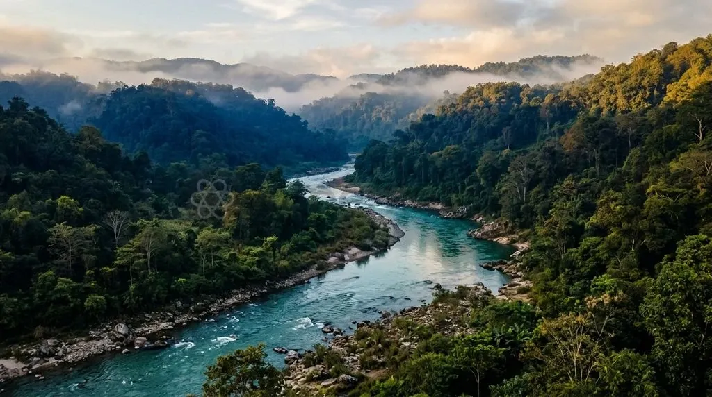
The Kulsi Multipurpose Project tests the fragile balance between regional clean energy expansion and statutory tribal self-governance under the Sixth Schedule. It also directly endangers India's national aquatic animal, the Gangetic river dolphin (Platanista gangetica). Northeastern states are pushing to harness river basins for low-carbon hydropower. Yet the proposal for a 62-metre dam near the Assam–Meghalaya border faces intense pushback from indigenous border communities and wildlife ecologists.
Major infrastructure projects across ecologically sensitive border corridors cannot succeed through top-down technical sanctions alone. They require prior, legally binding consent from customary tribal authorities. They also demand strict safeguards for vulnerable riverine species.
Why the Kulsi River Project Is Back in the News
The Kulsi Multipurpose Project gained renewed momentum on July 30, 2026. The Brahmaputra Board transferred the Detailed Project Report and project records for the 55 MW initiative to the Assam Power Generation Corporation Limited.
Key administrative milestones and public reactions include:
- Interstate Coordination: The administrative handover followed high-level intergovernmental coordination between the two frontier states. As of October 2026, the Government of Meghalaya had previously conveyed its conditional concurrence on June 17, 2025, to update the project blueprint following a bilateral Chief Minister-level conference held on June 2, 2025.
- Chiefs' Refusal: On October 8, 2026, three traditional Khasi Syiems—the hereditary chiefs of Hima Nongkhlaw, Hima Nongmynsaw, and Hima Rambrai—publicly declared their outright refusal to grant mandatory No-Objection Certificates for land diversion.
- Border Demonstrations: Simultaneously, over 2,000 residents coordinated under the Assam-Meghalaya Joint Protection Committee staged demonstrations along the border. They voiced alarm over the projected submergence of 46 border villages and the unchecked destruction of critical freshwater dolphin breeding habitats downstream.
Where the Kulsi Flows: Geography and River Basin Profile
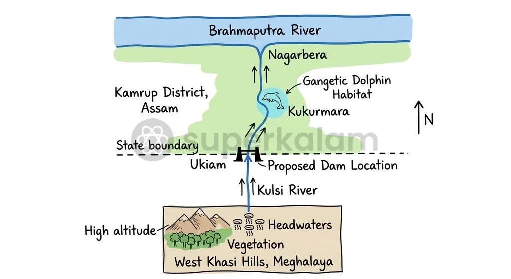
The Kulsi River originates as the Khri river in the West Khasi Hills of Meghalaya before carving its northern trajectory into Assam. The river cuts across deep gorges in the Meghalaya plateau. It then transverses the interstate boundary into Kamrup district in Assam, discharging into the Brahmaputra River near Nagarbera.
Its physical geography forms a distinct sub-basin on the southern bank of the Brahmaputra. The hydraulic regime relies on monsoonal run-off from the Khasi Hills. This flow sustains a complex hydrological network of sandbars, backwaters, and seasonal wetlands across lower Assam.
The downstream reaches shelter irreplaceable ecological features:
- The Kukurmara Stream Confluence: The junction where the Kukurmara stream joins the Batha river, known locally as Do-Mukhiya, forms a perennial deep pool. It is the primary nursery and feeding hub for the river's surviving cetacean population.
- Hydrological Dynamics: Monsoonal surges naturally flush fine silt through the riverbed. This preserves specific micro-depth channels vital for bottom-dwelling fish and riverine mammals.
- Anthropogenic Pressures: Intensive commercial sand mining in Kamrup district has degraded the natural riverbed structure. The resulting shallow reaches restrict dolphin movement during the lean dry season.
Discuss with Superkalam
At what specific confluence along the Kulsi River is the perennial deep pool nursery for the Gangetic river dolphin located?
Ask NowThe Hydroelectric Proposal: Capacity, Goals, and Interstate Context
The Kulsi Multipurpose Project was designed to meet multiple infrastructure objectives in Assam and Meghalaya. The Central Water Commission and the Ministry of Water Resources originally classified it as an identified National Project with an appraisal cost of ₹1,139.27 crore at 2014 price levels. Planners conceptualised the scheme to address regional energy deficits and agricultural irrigation.
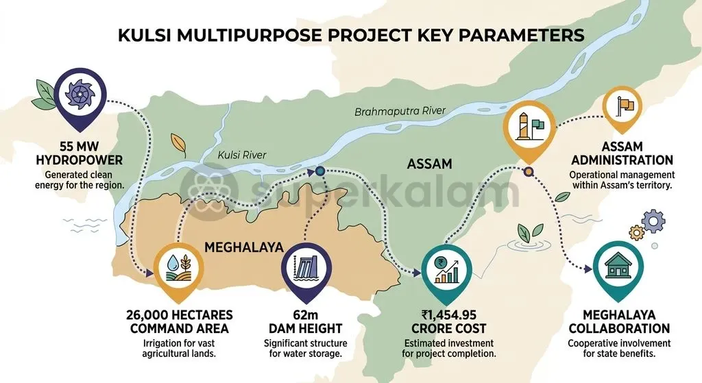
The Brahmaputra Board is a statutory body under the Union Ministry of Jal Shakti, established under the Brahmaputra Board Act, 1980. According to the Board, the revised DPR sets the project cost at ₹1,454.95 crore based on June 2017 price levels. The project's proposed infrastructure and design components comprise:
- Power Generation: An installed hydropower capacity of 55 MW to supply peak-load electricity to the regional grid.
- Irrigation Command Area: A planned gross command area of 26,000 hectares designed to boost agricultural productivity across Kamrup district.
- Flood Moderation: Incidental reservoir storage intended to cushion downstream plains against annual monsoonal surges.
- Dam Structure: A proposed 62-metre-high dam situated near Ukiam on the interstate border, roughly 80 km southwest of Guwahati.
| Project Dimension | Technical Parameter | Administrative Agency |
|---|---|---|
| Installed Capacity | 55 MW Hydroelectric Power | Assam Power Generation Corporation Limited (APGCL) |
| Command Area | 26,000 hectares (Gross) | Assam Water Resources Department |
| Capital Outlay | ₹1,454.95 crore (June 2017 price levels) | Central Assistance / State Funding Framework |
| Structural Height | 62 metres | Planned at Ukiam site |
| Statutory Planning Body | River Basin Master Plan Authority | Brahmaputra Board (Brahmaputra Board Act, 1980) |
The interstate location adds complex administrative challenges. The dam site at Ukiam lies between Borduar and Langpih, two of six historically contested sectors along the 884-km Assam–Meghalaya boundary. Although Meghalaya granted conditional concurrence in June 2025, that assent hinged on formal joint consultations with affected families, clear cost-and-power-sharing frameworks, and transparent rehabilitation packages.
Threat to the Gangetic River Dolphin: Ecology Under Strain
The primary ecological concern surrounding the Kulsi dam is the imminent risk to an isolated subpopulation of the Gangetic river dolphin (Platanista gangetica). The Kulsi River remains one of the few southern tributaries of the Brahmaputra that sustains an isolated, breeding group of this endangered freshwater cetacean.
Census assessments conducted by the Wildlife Institute of India reveal a concerning trajectory. The dolphin population in the Kulsi dropped to approximately 20 individuals in 2026, down from 29 recorded during earlier baseline surveys. This decline demonstrates how vulnerable these cetaceans are to changes in their river habitat.
Downstream Ecological Chain of Impact
- Dam Impoundment at Ukiam: Upstream reservoir storage traps water and interrupts natural flow pulses.
- Sediment Starvation: Silt retention alters the downstream hydrograph and disrupts natural sandbar dynamics.
- Pool Depletion: Water depths fall below the critical two-metre threshold required for echolocation and foraging.
- Trophic Disruption: Local prey-fish migrations collapse, cutting off dolphin food sources.
- Genetic Isolation: The barrier prevents movement, creating an acute extirpation risk for the roughly 20 surviving individuals.
Constructing a 62-metre barrier across the Kulsi would fundamentally alter the downstream river system. River impoundment traps essential silt, blocks local fish migrations, and severs genetic connectivity between the Kulsi dolphin group and the main stem of the Brahmaputra.
Reports from the Wildlife Institute of India indicate that Gangetic dolphins require water depths of at least two metres for regular navigation and hunting. Ongoing commercial sand mining already compromises this threshold. An upstream dam could lead to the permanent local loss of this endangered subpopulation.
Discuss with Superkalam
How does upstream sediment retention by a large dam alter the micro-depth channels required by freshwater cetaceans downstream?
Ask NowTribal Land Rights and the Issue of Consent Along the Border
The resistance from local indigenous communities highlights constitutional protections safeguarding tribal autonomy in Northeast India. The proposed reservoir at Ukiam threatens to submerge or disrupt 46 border villages inhabited by Bodo, Garo, Khasi, and Rabha communities. These communities manage land under customary tenurial systems rather than individual private deeds.
Two legal frameworks safeguard local tenure:
- Sixth Schedule Autonomy: Under the Sixth Schedule of the Constitution of India (operating under Articles 244(2) and 275(1)), traditional village institutions and Autonomous District Councils in Meghalaya hold statutory administrative authority over community land. The customary chiefs, known as Syiems, are legal custodians of community lands across their respective Himas. When the Syiems of Hima Nongkhlaw, Hima Nongmynsaw, and Hima Rambrai refused to issue No-Objection Certificates, they exercised their recognised constitutional prerogative. Without their formal consent, statutory land diversion for non-forest or infrastructure development cannot proceed through normal administrative channels.
- Forest Rights Act Consent: This customary protection is reinforced by the Scheduled Tribes and Other Traditional Forest Dwellers (Recognition of Forest Rights) Act, 2006. Under Section 4 of the Act, public authorities must recognise customary forest rights and obtain the free, prior informed consent of local Gram Sabhas before clearing forest lands or relocating indigenous populations.
The current impasse shows how major infrastructure projects stall when state agencies pursue bilateral executive pacts without securing prior community consent from constitutional tribal institutions.

Development Versus Conservation: Key Arguments on Both Sides
The Kulsi Multipurpose Project brings long-standing debates surrounding resource governance into sharp focus. State development agencies advocate for clean energy generation. Conversely, conservationists and local tribal groups highlight the severe ecological and social costs of large dams.
| Dimension | Development Imperative | Conservation & Rights Imperative |
|---|---|---|
| Energy & Water | 55 MW clean peak grid power; 26,000 ha assured irrigation | Hydrological collapse; destruction of artisanal river fisheries |
| Ecological Impact | Incidental flood moderation for downstream plains | Severe threat to roughly 20 surviving Gangetic dolphins |
| Governance & Land | Regional infrastructure integration between partner states | Submergence of 46 villages; breach of Sixth Schedule autonomy |
The Case for Development
Proponents of the project emphasise its long-term economic and infrastructural value:
- Low-Carbon Power Generation: Supplying 55 MW of hydroelectric capacity helps balance the regional grid and supports India's push for renewable energy.
- Agricultural Stabilisation: Providing assured irrigation to 26,000 hectares reduces reliance on erratic monsoon rainfall, boosting rural incomes across lower Assam.
- Monsoon Flood Buffering: Incidental storage can cushion riparian settlements against devastating flash floods originating in the Khasi Hills.
- Interstate Cooperation: Moving forward with joint river projects can help build trust and support diplomatic border negotiations between Assam and Meghalaya.
The Case for Conservation and Tribal Rights
Opponents argue that the project creates disproportionate ecological and social costs:
- Severe Biodiversity Loss: Altering the river's flow patterns could drive the local population of roughly 20 Gangetic dolphins to extirpation.
- Loss of Indigenous Livelihoods: Submerging 46 villages undermines traditional agro-forestry practices and fragments community territories across Bodo, Garo, Khasi, and Rabha settlements.
- Weakening of Customary Governance: Overlooking the formal objections of traditional Syiems weakens the self-governance protections established under the Sixth Schedule.
- Damage to River Hydrology: A static 62-metre dam traps silt, accelerates downstream riverbed erosion, and damages the artisanal fisheries that support local families.
Discuss with Superkalam
If an infrastructure project requires community land across an interstate border under the Sixth Schedule, what statutory hurdles must planners resolve before diversion?
Ask NowEthical Dilemmas: Energy Needs Versus Ecological Justice
The conflict surrounding the Kulsi basin illustrates fundamental questions within environmental ethics and public governance. It presents a classic confrontation between anthropocentric utilitarianism and ecocentric biocentrism.
From a utilitarian perspective, state utilities justify submerging local valleys by pointing to the aggregate public good: generating 55 MW of renewable power and irrigating thousands of hectares of farmland. Yet this calculation places the burdens of development onto small, marginalised communities while economic gains flow to urban centres and commercial electricity consumers.
| Ethical Framework | Core Premise | Kulsi Basin Manifestation |
|---|---|---|
| Utilitarian Calculus | Maximise aggregate welfare for the largest number | Supplies 55 MW grid power and 26,000 ha irrigation, but submerges 46 villages |
| Biocentric Justice | Protect intrinsic rights of non-human species | Demands survival of roughly 20 endangered dolphins and Sixth Schedule autonomy |
Conversely, biocentric ethics asserts that non-human species possess inherent moral worth independent of their utility to humans. Pushing the Gangetic dolphin—an evolutionary unique, blind freshwater mammal—toward local extinction to generate modest electrical output represents a major failure of environmental stewardship.
Simultaneously, the principles of environmental justice demand that development projects respect the rights of indigenous communities. The Sixth Schedule and the Forest Rights Act, 2006 were designed precisely to protect indigenous groups from involuntary dispossession. Proceeding with construction despite clear opposition from traditional Syiems and affected villagers undermines participatory democracy and procedural fairness.
The Path Ahead: Sustainable Run-of-the-River Alternatives and Meaningful Dialogue
Resolving the Kulsi river impasse requires shifting away from high-impact infrastructure models toward adaptive, participatory basin management. Large storage dams with high reservoirs are increasingly unsuited for ecologically sensitive and geologically active border corridors.
Policymakers and project authorities should focus on key institutional and engineering alternatives:
- Evaluating Run-of-the-River Alternatives: The Central Electricity Authority and project planners should assess whether a smaller, run-of-the-river design could generate power without a 62-metre storage dam, preserving downstream water flows and sediment transport.
- Securing Prior Informed Consent: The governments of Assam and Meghalaya must respect statutory tribal consultation processes. Project designs should not proceed without the formal consent of the Khasi Syiems, Autonomous District Councils, and local Gram Sabhas under Section 4 of the Forest Rights Act, 2006.
- Enforcing Strict Environmental Flows: If any minor diversion structures are considered, authorities must establish legally binding, perennial environmental flow mandates verified by the Wildlife Institute of India to preserve critical deep-water pools at the Kukurmara confluence.
- Creating a Joint Interstate Conservation Authority: Assam and Meghalaya should establish a collaborative management council under the Ministry of Jal Shakti to halt destructive commercial sand mining and implement holistic river basin conservation.
Discuss with Superkalam
Compare the potential benefits of peak-load hydropower and irrigation against the risks of submerging 46 tribal border villages.
Ask NowKey Takeaways
- Project Profile: The Kulsi Multipurpose Project is a planned 55 MW hydroelectric and irrigation project situated near Ukiam on the Assam–Meghalaya boundary, carrying an estimated outlay of ₹1,454.95 crore at June 2017 price levels.
- Downstream Ecology: The Kulsi River shelters an isolated, declining subpopulation of the endangered Gangetic dolphin (Platanista gangetica), which dropped from 29 to roughly 20 individuals in 2026.
- Critical Habitat Zones: The confluence of the Kukurmara stream and Batha river (Do-Mukhiya) is the primary feeding and nursery habitat for dolphins, requiring water depths of at least two metres that would be severely altered by an upstream dam.
- Tribal Autonomy and Refusal: On October 8, 2026, traditional Khasi Syiems from Hima Nongkhlaw, Hima Nongmynsaw, and Hima Rambrai refused to grant mandatory No-Objection Certificates, asserting customary land protections under the Sixth Schedule.
- Social Impact: The Assam-Meghalaya Joint Protection Committee has mobilised local Bodo, Garo, Khasi, and Rabha communities against the project, pointing out that the proposed reservoir threatens to submerge or displace 46 border villages.
- Policy Way Forward: Sustainable basin planning requires evaluating run-of-the-river alternatives, securing free, prior, and informed consent under the Forest Rights Act, 2006, and establishing binding environmental flow protections.
Mains Question
"Major infrastructure projects across ecologically sensitive border corridors cannot succeed through top-down technical sanctions alone; they require prior, legally binding consent from customary tribal authorities." In light of the Sixth Schedule protections and the refusal of Khasi Syiems regarding the Kulsi Multipurpose Project, examine this statement. (10 Marks)
Evaluate NowMains Question
The proposed 62-metre dam on the Kulsi River highlights the tension between regional clean energy expansion and the conservation of India's national aquatic animal. Critically analyse the ecological ramifications of river impoundment on the Gangetic river dolphin (Platanista gangetica) subpopulation in the Brahmaputra sub-basin. (15 Marks)
Evaluate NowPractice MCQs
QUESTION 1
With reference to the Kulsi River, consider the following statements:
- It originates as the Khri river in the West Khasi Hills of Meghalaya.
- It flows southwards from the plains of Assam into the Meghalaya plateau.
- It empties directly into the Bay of Bengal without joining any other major river system. Which of the statements given above is/are correct?
QUESTION 2
Consider the following statements regarding the Gangetic river dolphin (Platanista gangetica) in the Kulsi River basin:
- The confluence of the Kukurmara stream and the Batha river forms a perennial deep pool that serves as a primary nursery and feeding hub.
- Gangetic river dolphins require a minimum river water depth of two metres for regular navigation and hunting.
- The dolphin subpopulation in the Kulsi River increased between baseline surveys and the 2026 census. Which of the statements given above are correct?
QUESTION 3
Regarding the statutory and institutional framework of the Kulsi Multipurpose Project, consider the following statements:
- The Brahmaputra Board is a statutory body established under the Brahmaputra Board Act, 1980.
- The Detailed Project Report was transferred by the Brahmaputra Board to the Assam Power Generation Corporation Limited.
- The project is planned for an installed hydropower capacity of 55 MW with a 62-metre-high dam located at Ukiam. Which of the statements given above is/are correct?
QUESTION 4
Under the Sixth Schedule of the Constitution of India operating along the Assam–Meghalaya border, customary authority over community lands in Khasi Himas is vested in:
QUESTION 5
Consider the following statements regarding the opposition to the proposed Kulsi Multipurpose Project:
- The project reservoir threatens to submerge or disrupt 46 border villages inhabited by Bodo, Garo, Khasi, and Rabha communities.
- The dam site at Ukiam lies along an uncontested, fully demarcated sector of the interstate border.
- The Syiems refused to grant mandatory No-Objection Certificates for land diversion. Which of the statements given above are correct?