India's Land Degradation Neutrality: Targets vs Ecological Reality
Beyond administrative tree-planting quotas, India's target to restore 26 million hectares faces structural challenges in soil carbon recovery and land mapping.
Aug, 2026
•12 min read
Overview
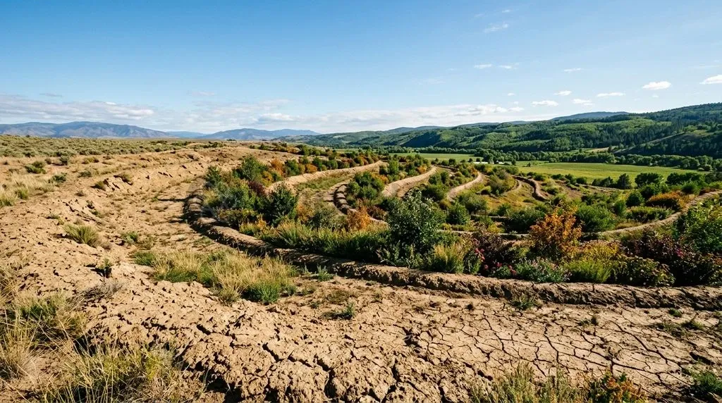
Land Degradation Neutrality is an urgent ecological mandate for India. It requires that the total quantity and productive quality of land resources remain stable or improve. This balance safeguards ecosystem functions, food security, and rural livelihoods across diverse biomes.
Under United Nations Sustainable Development Goal Target 15.3, the framework enforces a no net loss balance sheet. Any unavoidable land degradation must be counterbalanced by genuine ecological recovery. However, India's headline international commitments mask a structural rift between administrative afforestation accounting and verified biophysical recovery.
Pledges scaled from 21 million hectares under the Bonn Challenge to 26 million hectares by 2030 at the UNCCD COP14 summit. While agencies report millions of hectares restored through sectoral planting, satellite and soil data reveal persistent land degradation driven by water erosion, soil carbon loss, and the conversion of open natural biomes into commercial monocultures.
Why Land Degradation Neutrality is Back in Focus for India
Land Degradation Neutrality has re-emerged as a core policy priority as national planning confronts escalating climate vulnerabilities, declining soil organic matter, and international environmental commitments.
As of August 2026, India continues to align its domestic restoration strategies with the United Nations Convention to Combat Desertification (UNCCD) framework following its pledge to restore 26 million hectares of degraded land by 2030.
Several pressing ecological factors drive this renewed policy focus:
- Agricultural Stability: Unsustainable land management and erratic rainfall continue to erode fertile topsoils across major river basins and rainfed agricultural tracts.
- Biome Diversification: The Ministry of Environment, Forest and Climate Change launched its first official Guide to Grasslands and Other Open Natural Ecosystems at UNCCD COP17 in Ulaanbaatar, formally recognising the ecological role of non-forest biomes in meeting national conservation targets.
- Target Realignment: Policy must shift beyond bureaucratic tree-planting tallies toward verifiable biophysical restoration that protects rural livelihoods and restores natural soil fertility.
Understanding the Concept: The 'No Net Loss' Rule and Biophysical Metrics
The UNCCD defines Land Degradation Neutrality as maintaining or enhancing ecosystem functions and food security within specified spatial and temporal scales. The framework operates on a no net loss mechanism. Unavoidable degradation in one landscape must be balanced by equal ecological gains achieved through planned restorative measures elsewhere.
The response hierarchy guides implementation through three sequential steps:
- Avoid: Prevent land degradation through sustainable spatial planning and conservation.
- Reduce: Minimise ongoing degradation through sustainable land and soil management.
- Reverse: Restore degraded ecosystems through active biophysical interventions.
The global monitoring architecture for Sustainable Development Goal Indicator 15.3.1 evaluates land health using three mandatory biophysical sub-indicators, as outlined in the Good Practice Guidance published by the UNCCD:
| Biophysical Sub-Indicator | Measurement Focus | Primary Assessment Tool | Ecological Relevance for India |
|---|---|---|---|
| Land Cover Change | Spatial transitions in vegetation, water bodies, and settlements | Multi-spectral satellite remote sensing | Detects deforestation, wetland loss, and urban sprawl |
| Land Productivity Dynamics | Net primary productivity and photosynthetic activity trends | Long-term NDVI time-series satellite data | Identifies declining vegetative vigour and agricultural yield decline |
| Soil Organic Carbon (SOC) | Mass of carbon stored in topsoil (0–30 cm depth) | Ground soil sampling and calibrated spatial modelling | Measures fundamental soil health, microbial life, and water retention capacity |
To prevent superficial accounting from obscuring real land decline, the UNCCD applies the strict One-Out, All-Out aggregation rule. Under this rule, if any single sub-indicator among Land Cover, Land Productivity Dynamics, or Soil Organic Carbon exhibits a statistically significant negative trend, the entire land unit is formally classified as degraded.
This method ensures that an increase in green canopy coverage cannot compensate for declining topsoil organic carbon or hydrological exhaustion.
Discuss with Superkalam
What are the three sequential steps of the Land Degradation Neutrality response hierarchy?
Ask Now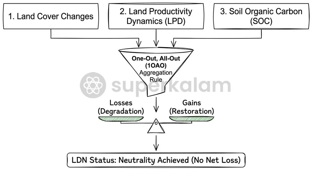
India's Pledges: From the Bonn Challenge to the 26 Million Hectare Goal
India joined the international Bonn Challenge in 2015, initially committing to bring 21 million hectares of degraded and deforested land under ecological restoration by 2030. At the High-Level Segment of the 14th Conference of Parties to the UNCCD hosted in New Delhi, the Government of India formally raised this target to 26 million hectares by 2030.
Official progress reports submitted under international reporting frameworks highlight significant administrative progress across multiple sectoral programmes. According to reporting released by the Ministry of Environment, Forest and Climate Change, India brought 21.76 million hectares of degraded land under restoration between 2011 and 2020, generating roughly 1.22 billion person-days of rural employment.
These restoration totals integrate inputs from several major public schemes:
- Compensatory Afforestation Fund Management and Planning Authority (CAMPA) plantations.
- The Watershed Development Component of Pradhan Mantri Krishi Sinchayee Yojana (PMKSY-WDC).
- Social forestry, joint forest management, and community agroforestry programmes.
- Soil conservation and water harvesting works under the Mahatma Gandhi National Rural Employment Guarantee Scheme.
While these administrative numbers indicate substantial state expenditure and physical activity, counting planted saplings does not confirm long-term biological survival or improved soil function.
Discuss with Superkalam
Why does an increase in satellite-detected green canopy cover fail to prove that a degraded ecosystem has genuinely recovered?
Ask NowThe Accounting Gap: Why Area Coverage Does Not Equal Ecological Recovery
India's official restoration accounting relies heavily on administrative inputs rather than multi-year biophysical assessments verified through the UNCCD One-Out, All-Out framework. This reliance creates a persistent gap where bureaucratic target completion is conflated with genuine ecological restoration.
The divergence between administrative targets and verified ecological recovery centres on key trade-offs:
- Input vs Outcome: Sapling tallies do not equate to long-term soil carbon accumulation.
- Canopy vs Hydrology: Fast-growing monoculture tree canopies often deplete rather than recharge local groundwater tables.
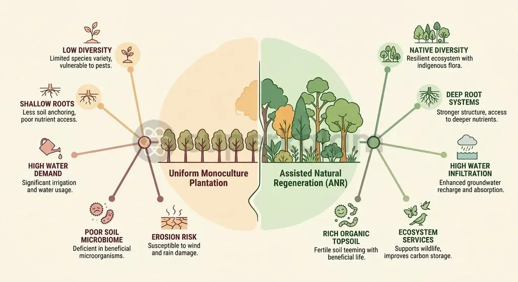
A major limitation of input-driven afforestation under CAMPA and state forest departments is the widespread reliance on fast-growing commercial monocultures. Government agencies frequently plant non-native species such as Eucalyptus, Acacia, and Conocarpus to meet annual area targets rapidly. According to ecological findings documented in the official Guide to Grasslands and Open Natural Ecosystems, establishing fast-growing monocultures on dry landscapes causes rapid depletion of groundwater and disrupts native biodiversity.
Monoculture plantations fail to rebuild the complex multi-tiered canopy, deep root structures, and soil microbial communities found in natural native forests:
- Hydrological Imbalances: Deep-rooted fast-growing alien trees extract substantial water from shallow aquifers without enhancing natural percolation.
- Soil Carbon Deficits: Monoculture litter fall decomposes differently compared to diverse native vegetation, often failing to stabilise long-term soil organic carbon stocks.
- Biodiversity Depletion: Homogeneous tree stands do not provide appropriate foraging or nesting habitats for indigenous fauna, undermining broader ecosystem resilience.
True land degradation neutrality requires that restored sites exhibit verified increases in soil organic carbon, sustained primary productivity, and native species diversity over a multi-year baseline.
Conflicting Maps: How ISRO and MoEFCC Data Diverge on Degraded Land
The Space Applications Centre of the Indian Space Research Organisation (SAC-ISRO) provides the empirical baseline for mapping national degradation patterns. In the Desertification and Land Degradation Atlas of India, SAC-ISRO determined that 97.85 million hectares, or 29.77% of India's Total Geographic Area, underwent degradation during the 2018–19 monitoring cycle.
This spatial mapping reveals a clear divide:
- Satellite Observations: The SAC-ISRO Atlas establishes that 29.77% of Total Geographic Area was degraded in 2018–19.
- Departmental Records: Sectoral reporting tracks cumulative plantation expenditure and seedling distribution targets without measuring post-planting survival.
This spatial mapping exposes a divergence between satellite-observed land degradation and the cumulative restoration figures reported by sectoral ministries:
- Methodological Disconnect: SAC-ISRO utilises multi-temporal satellite imagery to classify physical land degradation processes across terrain, whereas administrative reports aggregate cumulative budgetary disbursements and gross sapling distribution.
- Persistence of Degradation: Even as ministries record millions of hectares treated under watershed and afforestation schemes, remote-sensing data indicates that net degraded acreage expanded across several states between 2011–13 and 2018–19.
- Temporal Vulnerability: Plantation areas that experience subsequent sapling mortality due to drought, grazing, or poor maintenance continue to appear as "restored" in departmental records, despite reverting to degraded status on satellite land-cover maps.
Reconciling this divergence requires embedding periodic satellite-based biophysical audits into the monitoring frameworks of all central and state land-restoration schemes.
Discuss with Superkalam
How can district-level planning under CAMPA and MGNREGS incorporate the 'One-Out, All-Out' rule to measure real ecological outcomes?
Ask NowWhere and Why India is Losing Soil Health Across Major Landscapes
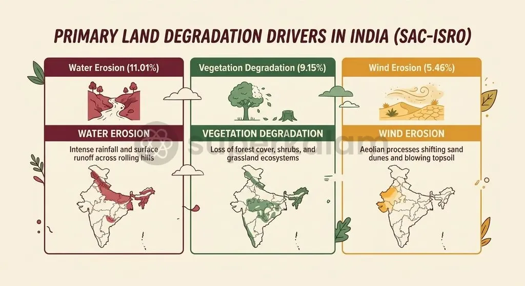
Land degradation in India is driven by water erosion, unsustainable agricultural intensification, vegetative clearing, and wind erosion across arid zones. Spatial analysis from the SAC-ISRO Atlas establishes the relative contribution of each primary degradation process across the country:
- Water Erosion: 11.01% of Total Geographic Area, making it the single largest driver of topsoil loss.
- Vegetation Degradation: 9.15% of Total Geographic Area, primarily affecting open forest canopies and rangelands.
- Wind Erosion: 5.46% of Total Geographic Area, concentrated in arid western tracts.
According to SAC-ISRO data, over 23.79% of India's total desertification and land degradation is concentrated across nine states and union territories: Rajasthan, Maharashtra, Gujarat, Karnataka, Ladakh, Jharkhand, Odisha, Madhya Pradesh, and Telangana.
In semi-arid western India, the degradation of ancient ecological buffers has accelerated sand drift and topsoil loss. To counter these pressures, the Union Government initiated the Aravalli Green Wall Project, which aims to establish a 5-kilometre green buffer corridor across Gujarat, Rajasthan, Haryana, and Delhi to halt eastward desert expansion from the Thar Desert.
In rainfed agricultural belts, excessive chemical fertiliser applications, declining organic manure inputs, and intensive tillage have depleted topsoil organic matter, lowering water-holding capacity and exacerbating drought susceptibility.
Discuss with Superkalam
Compare the methodological differences between SAC-ISRO's satellite-based degradation mapping and the administrative restoration reports published by sectoral ministries.
Ask NowCurrent Policy Instruments: Assessing Watershed, Forest, and Farm Programs
India's policy architecture addresses land degradation through an array of statutory frameworks, centrally sponsored schemes, and conservation missions across ministries.
The sectoral policy landscape spans three core domains:
- Watershed Management: The PMKSY-WDC executes ridge-to-valley soil-and-water conservation interventions.
- Forestry Missions: CAMPA and the National Mission for a Green India finance afforestation and canopy enrichment.
- Agronomic Schemes: The Soil Health Card Scheme and micro-irrigation programmes support on-farm nutrient and moisture conservation.
The primary sectoral interventions include:
- PMKSY - Watershed Development Component: Administered by the Department of Land Resources, this programme executes ridge-to-valley soil-and-water conservation measures, constructing check dams and contour bunds to reduce surface runoff.
- National Mission for a Green India (GIM): An operational mission under the National Action Plan on Climate Change that seeks to enhance forest cover and ecosystem service quality on degraded forest lands.
- Soil Health Card Scheme: An agricultural intervention providing farmers with field-specific nutrient diagnostics and secondary micronutrient recommendations to correct soil chemistry imbalances.
- National Afforestation Programme: Focuses on the ecological rehabilitation of degraded forests through Joint Forest Management Committees composed of local village residents.
While these programmes receive substantial budgetary outlays, their execution often suffers from fragmented inter-departmental coordination. Watershed management, agriculture, and forestry operate under distinct administrative hierarchies, preventing unified landscape-level planning.
The Human Cost: What Degraded Commons Mean for Pastoralists and Smallholders
Common property resources—such as village grazing pastures, scrublands, and seasonal wetlands—provide essential subsistence support, fodder, and fuel for millions of marginal farmers, landless labourers, and nomadic pastoralist communities across rural India.
A critical policy challenge is the systematic mischaracterisation of dryland biomes. Comparative ecological studies demonstrate that over 65% of India's semi-arid Open Natural Ecosystems (such as savannas, grasslands, and thorn scrub) have historically been misclassified as unproductive "wastelands" in official land-use atlases.
This misclassification triggers a destructive policy chain:
- Official land records label productive grasslands as "wastelands".
- Agencies allocate these lands for commercial tree plantations or infrastructure.
- The resulting enclosure causes pastoral displacement and the destruction of indigenous biodiversity.
This classification leads state authorities to divert functional grasslands for commercial industrial tree plantations, solar parks, or compensatory afforestation drives. Planting dense trees in native open grasslands undermines the livelihoods of traditional pastoralists, including the Maldhari, Raika, and Gujjar communities, by eliminating grazing pastures.
Furthermore, clearing community rangelands for administrative afforestation projects infringes upon the statutory Community Forest Resource rights guaranteed under Section 3(1)(i) of the Scheduled Tribes and Other Traditional Forest Dwellers (Recognition of Forest Rights) Act, 2006 (FRA). When Gram Sabhas are bypassed in compensatory afforestation decisions, local resource stewardship is eroded, accelerating resource conflicts.
Discuss with Superkalam
Evaluate the ecological trade-offs of using fast-growing commercial tree species versus native grassland restoration in semi-arid river basins.
Ask NowWay Forward: Shifting from Monoculture Targets to Verified Soil Carbon Restoration
Transitioning from administrative plantation quotas to verifiable ecological recovery requires restructuring India's land-use governance around scientific ecological principles and local community rights. Technical assessments by the UNCCD Science-Policy Interface recommend adopting Assisted Natural Regeneration, combined with high-resolution satellite tracking and ground-truthed soil carbon testing.
To achieve authentic Land Degradation Neutrality, policy implementation should focus on the following priorities:
- Adopting Assisted Natural Regeneration: State forest agencies must prioritise the natural regeneration of indigenous pioneer species over artificial tree planting, enabling native ecosystems to recover ecological complexity at lower public cost.
- Institutionalising the 1OAO Framework: The Ministry of Environment, Forest and Climate Change should align domestic restoration monitoring with the UNCCD One-Out, All-Out rule, requiring all reported hectares to demonstrate verified improvements in Land Productivity Dynamics and Soil Organic Carbon.
- Establishing Rigorous Soil Carbon Baselines: Implement nationwide, geo-referenced baseline sampling for topsoil organic carbon (0–30 cm) using standardised laboratory protocols to ground-truth satellite vegetation indexes.
- Revising Land Classification Standards: The Ministry of Rural Development and state revenue departments must amend land records to recognise Open Natural Ecosystems (grasslands, savanna woodlands, and desert scrub) as ecologically valuable biomes rather than wastelands.
- Decentralising Governance via the Forest Rights Act: Enforce Section 3(1)(i) of the Forest Rights Act, 2006, ensuring that Gram Sabhas retain decision-making authority over all CAMPA afforestation and watershed interventions planned on customary village commons.
By shifting incentives from superficial area targets to measurable gains in soil carbon, water retention, and rural community rights, India can transform its land degradation commitments into genuine ecological resilience.
Key Takeaways
- Land Degradation Neutrality under SDG Target 15.3 requires a no net loss balance where new land degradation is counterbalanced by genuine ecological restoration.
- The UNCCD evaluates land health via three mandatory sub-indicators—Land Cover, Land Productivity Dynamics, and Soil Organic Carbon—aggregated under the strict One-Out, All-Out rule.
- India committed to restoring 26 million hectares by 2030 at UNCCD COP14, having previously reported 21.76 million hectares under restoration between 2011 and 2020 under the Bonn Challenge.
- According to the SAC-ISRO Atlas, 97.85 million hectares (29.77% of TGA) was degraded in 2018–19, with water erosion (11.01%) and vegetative decline (9.15%) as the primary drivers.
- Misclassifying over 65% of Open Natural Ecosystems as wastelands has led to destructive monoculture plantations that deplete shallow groundwater and compromise pastoral rights under Section 3(1)(i) of the Forest Rights Act, 2006.
Mains Question
"India's headline international restoration commitments under the Bonn Challenge and UNCCD mask a structural rift between administrative afforestation accounting and verified biophysical recovery." Critically analyse. (15 Marks)
Evaluate NowMains Question
Examine how the UNCCD's 'One-Out, All-Out' aggregation rule and response hierarchy can help reorient India's land restoration policy away from monoculture plantations toward genuine soil carbon and ecosystem recovery. (10 Marks)
Evaluate NowPractice MCQs
QUESTION 1
With reference to the global monitoring framework for Sustainable Development Goal (SDG) Indicator 15.3.1 on Land Degradation Neutrality (LDN), consider the following statements:
- The framework evaluates land health using three mandatory biophysical sub-indicators: Land Cover Change, Land Productivity Dynamics, and Soil Organic Carbon.
- Soil Organic Carbon is assessed by measuring the mass of carbon stored in topsoil up to a depth of 100 cm.
- Under the 'One-Out, All-Out' aggregation rule, if any single sub-indicator exhibits a statistically significant negative trend, the entire land unit is classified as degraded.
Which of the statements given above are correct?
QUESTION 2
Consider the following statements regarding India's international commitments and policy initiatives on land restoration:
- At the UNCCD COP14 in New Delhi, India raised its restoration target from 21 million hectares under the Bonn Challenge to 26 million hectares by 2030.
- The Ministry of Environment, Forest and Climate Change released its first official Guide to Grasslands and Other Open Natural Ecosystems at UNCCD COP17 in Ulaanbaatar.
- The Land Degradation Neutrality response hierarchy prioritises 'Reverse' (restoration) ahead of 'Avoid' and 'Reduce'.
Which of the statements given above is/are correct?
QUESTION 3
Consider the following statements regarding land degradation mapping in India:
- According to SAC-ISRO's Desertification and Land Degradation Atlas of India, 97.85 million hectares or 29.77% of India's Total Geographic Area underwent degradation during the 2018–19 cycle.
- Departmental restoration reporting matches ISRO's satellite data because both rely on multi-temporal NDVI time-series satellite imagery to measure post-planting survival.
- Sectoral restoration figures integrate inputs from CAMPA plantations and the Watershed Development Component of Pradhan Mantri Krishi Sinchayee Yojana (PMKSY-WDC).
Which of the statements given above is/are correct?
QUESTION 4
In the context of the UNCCD Land Degradation Neutrality (LDN) framework, what is the precise operational meaning of the 'no net loss' mechanism?
QUESTION 5
Consider the following statements regarding the ecological consequences of commercial monoculture plantations (Eucalyptus, Acacia, Conocarpus) on degraded drylands:
- Fast-growing alien monocultures rapidly deplete shallow groundwater aquifers without enhancing natural percolation.
- Monoculture leaf litter establishes identical microbial and soil organic carbon profiles as multi-tiered native vegetation.
- Homogeneous monoculture stands fail to provide appropriate foraging and nesting habitats for native wildlife.
Which of the statements given above are correct?