Himalayan Glacier Melt and GLOF Risk: Economy, Energy and Disaster Governance
Third Pole cryosphere retreat threatens over a fifth of India's GDP and critical energy assets, pushing disaster governance toward structural resilience against GLOFs.
Sep, 2026
•9 min read
Context
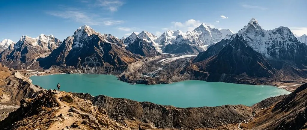
Accelerating cryospheric retreat across the Hindu Kush Himalaya is turning Glacial Lake Outburst Floods from isolated mountain hazards into a systemic macroeconomic threat. These outburst floods jeopardise energy infrastructure, downstream agrarian stability, and over one-fifth of India's Gross Domestic Product.
Rapid glacial melting expands high-altitude moraine-dammed lakes. This creates catastrophic flash-flood risks that directly threaten river basin populations and downstream capital assets. Economic activities worth approximately ₹64.8 lakh crore depend on Himalayan water basins, making cryosphere protection vital for national economic resilience.
Why in the News: The Accelerating Retreat of Third Pole Glaciers
Glacial retreat across the Third Pole has shifted from a gradual warming trend into a rapid regional crisis. Recent field and satellite surveys highlight several alarming benchmarks:
- Accelerating Mass Loss: The International Centre for Integrated Mountain Development documented a sixty-five percent acceleration in glacier mass loss during the 2011 to 2020 decade.
- Annual Thinning Rates: As of October 2024, scientific monitoring confirms that regional glaciers shrank at an average rate of 0.28 metres water equivalent annually compared to the preceding decade.
- Long-Term Volume Loss: Under current greenhouse gas emission trajectories, glaciologists project that the wider mountain range could shed up to eighty percent of ice volume by 2100.
- Expanding Lake Area: Satellite monitoring by the Central Water Commission reveals that the total glacial lake inventory area inside India expanded by 33.7 percent between 2011 and 2024, growing from 1,962 hectares to 2,623 hectares across the Indian Himalayan Region.
This hydrological shift enlarges unstable proglacial lakes perched directly above densely populated valleys and critical public infrastructure.
What Are Glacial Lake Outburst Floods (GLOFs) and How Do They Form?
The National Disaster Management Authority defines Glacial Lake Outburst Floods as catastrophic hydrological discharges caused by the sudden failure of naturally formed moraine dams holding high-altitude meltwater.
As glaciers retreat under warming ambient temperatures, receding ice fronts leave behind deep depressions bordered by unconsolidated glacial till consisting of loose sediment, gravel, and boulders. Meltwater accumulates behind these unstable natural moraines, creating expanding proglacial lakes.
Destabilisation occurs when external physical triggers compromise the fragile structural integrity of the moraine dam:
- Permafrost Degradation: Subsurface ice within the moraine matrix thaws, reducing shear strength and triggering slope subsidence.
- Cryospheric Avalanches: Massive ice or rock avalanches detach from steep headwalls and plunge into the lake, generating displacement waves that overtop the terminal moraine.
- Hydrostatic Pressure: Rapid meltwater influx elevates hydraulic pressure against the moraine wall beyond its structural bearing capacity.
- Extreme Precipitation: Cloudburst events deliver sudden surface runoff that cuts rapid breach channels across the loose embankment material.
| Parameter | Glacial Lake Outburst Flood (GLOF) | Cloudburst Flash Flood |
|---|---|---|
| Primary Mechanism | Structural failure of an unstable moraine or ice dam | Extreme localized convective rainfall exceeding 100 mm per hour |
| Origin Altitude | High-altitude glacial zones (typically above 3,500 metres) | Mid-to-high altitude mountain slopes and narrow valleys |
| Warning Lead Time | Moderate (satellite and sensor tracking of lake volume) | Extremely low (sudden convective atmospheric build-up) |
| Sediment Load | Extremely high (massive boulders, glacial till, pulverized rock) | High (riverbed debris, topsoil, and uprooted vegetation) |
Discuss with Superkalam
Recall the two major hydropower projects that suffered severe structural damage during the 2021 Chamoli disaster.
Ask Now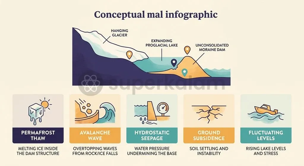
The Economic Spillover: How Glacier Melt Threatens India's GDP
A joint assessment revealed that economic output worth ₹64.8 lakh crore directly and indirectly relies on Himalayan water systems. This vast valuation represents approximately 21.5 percent of India's GDP for FY2023–24, spanning agriculture, river navigation, industrial manufacturing, and municipal water supplies.
Physical devastation from sudden GLOF events damages national accounts through three distinct transmission channels:
- Direct Capital Stock Destruction: Flood surges wash away transport corridors, bridges, communication lines, and power-generation units.
- Operational Downtime: Protracted power and transit outages disrupt regional supply chains and industrial operations across adjoining plains.
- Fiscal Strain: High-magnitude rebuilds exhaust state disaster mitigation funds while driving up capital borrowing costs for future infrastructure.
Hydropower Infrastructure at Risk: Lessons from Chamoli and South Lhonak
The Central Electricity Authority has catalogued forty-seven hydroelectric dams across the Indian Himalayan Region as vulnerable to catastrophic glacial hazards and outburst surges. Of these threatened installations, thirty-eight commissioned hydropower projects and nine under-construction facilities operate directly in downstream flood hazard pathways.
The vulnerability of run-of-the-river hydropower designs became evident during the South Lhonak Lake disaster in Sikkim on October 4, 2023. A sudden breach of South Lhonak Lake unleashed a massive sediment-laden flood wave down the Teesta basin, causing the total structural destruction of the 1,200 MW Teesta-III Hydroelectric Project dam at Chungthang.
Hydropower Vulnerability Sequence:
- Glacier Mass Loss: Sustained atmospheric warming accelerates ice volume retreat.
- Moraine Lake Expansion: Meltwater collects in loose, structurally weak terminal basins.
- Upstream Trigger Event: Rockfalls, ice calving, or heavy rain overtop the natural moraine dam.
- Dam Breach: Sudden high-velocity discharge surges downstream.
- Downstream Asset Loss: Mud, debris, and boulders demolish power plants and civic infrastructure.
A parallel disaster struck Uttarakhand on February 7, 2021, when a massive rock and ice avalanche from Ronti peak cascaded into the Rishiganga valley. The ensuing high-velocity slurry obliterated the 13.2 MW Rishiganga small hydro project and inflicted devastating structural damage on NTPC's 520 MW Tapovan-Vishnugad project, resulting in over ₹1,600 crore in asset losses.
Discuss with Superkalam
Explain the physical mechanism through which a rock or ice avalanche triggers a terminal moraine breach in a proglacial lake.
Ask Now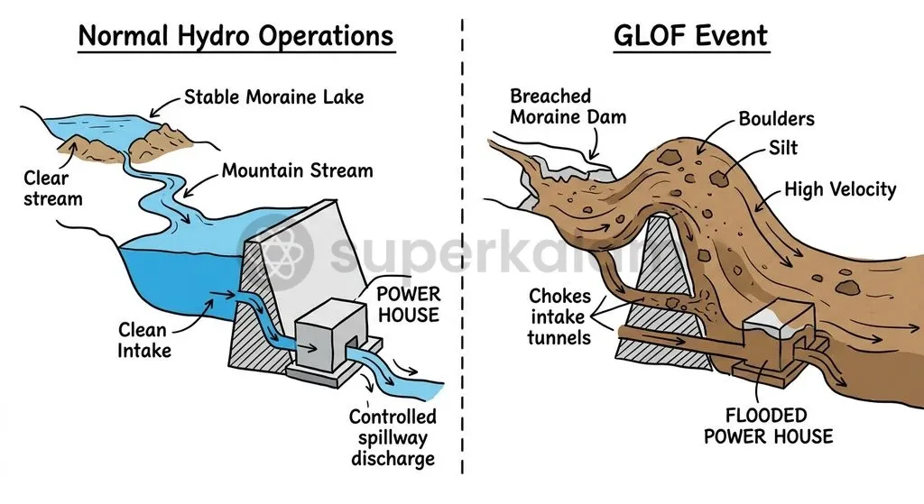
Impact on Agriculture and Downstream Food Security in the Indo-Gangetic Plain
The Hindu Kush Himalaya assessment by ICIMOD warns that major river basins face peak water runoff by mid-century, threatening long-term agricultural stability across northern India. Accelerated melt rates temporarily augment streamflow in the Indus, Ganga, and Brahmaputra basins, but will eventually trigger a steep decline in dry-season baseflow once glacial reservoirs deplete.
This hydrological transition threatens the double-cropping patterns of Punjab, Haryana, and Uttar Pradesh:
- Rabi Crop Vulnerability: Wheat and mustard production rely on stable canal supplies fed by winter baseflows when monsoon precipitation is absent.
- Sediment Deposition: Outburst floods deposit coarse glacial silt and infertile debris across fertile floodplains, degrading arable acreage.
- Aquifer Depletion: Reduced lean-season river discharge decreases natural recharge rates for alluvial groundwater tables across northern river basins.
India's Disaster Governance Architecture: NDMA Guidelines and Early Warning Systems
The Ministry of Home Affairs sanctioned the ₹150 crore National GLOF Risk Mitigation Project under the National Disaster Mitigation Fund to safeguard four high-risk Himalayan states. This structural initiative targets vulnerable catchment zones across Himachal Pradesh, Uttarakhand, Sikkim, and Arunachal Pradesh.
Hydrological monitoring led by the Central Water Commission tracks 902 high-altitude glacial lakes and water bodies annually between June and October. Through systematic satellite inventories, the commission classified 67 glacial lakes as high-risk, following surface area expansions exceeding 40 percent between 2011 and 2024.
Operational Framework of High-Altitude GLOF Early Warning Systems:
- Sub-surface Buoy Sensors: Measure real-time water levels and hydrostatic pressure in expanding glacial lakes.
- Automated Weather Stations: Track intense mountain rainfall and sudden temperature anomalies.
- INSAT Telemetry Link: Relays sensor signals instantly across rough mountain topography.
- State Disaster Control Room: Processes sensor telemetry against predefined breach thresholds.
- Siren and Evacuation Protocols: Dispatches emergency alerts to evacuate vulnerable downstream communities.
Technological adaptation has advanced through an automated GLOF Early Warning System Proof of Concept deployed by the National Disaster Management Authority at Sissu Lake in Himachal Pradesh. The field installation combines water-level buoy sensors, automated meteorological stations, and satellite telemetry links to transmit real-time hazard triggers to emergency response units. A different mountain-hazard chain struck on 26 August 2026: a rock-ice collapse on Nepal's Langtang Lirung massif became a debris-flow and flood cascade across the Gyirong-Rasuwagadhi border. Researchers identify three risk 'clocks': long-term slope preconditioning, minute-scale downstream propagation and institutional response. The lesson for early warning is to link source detection to cross-border, impact-based alerts and pre-authorised downstream action. This was a rock-ice cascade, not evidence of a moraine-dam GLOF at this site.
Discuss with Superkalam
How would the depletion of lean-season river baseflows alter cropping choices and irrigation practices in Punjab and Haryana?
Ask Now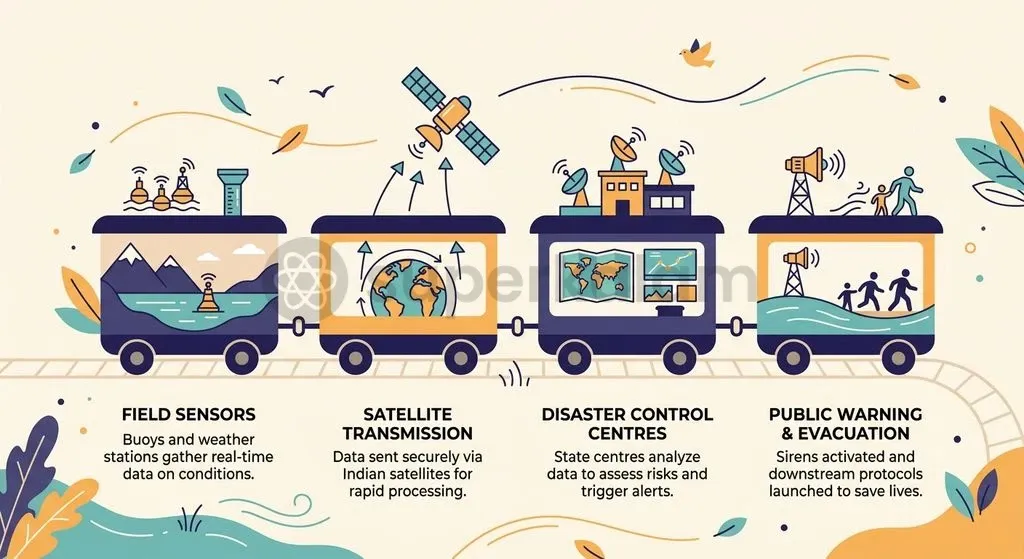
Cross-Border Challenges: Transboundary Rivers and Regional Data Sharing
The Ministry of External Affairs confirmed that transboundary hydrological data sharing with China remains restricted to non-binding, seasonal Memorandums of Understanding on the Yaluzangbu and Brahmaputra. The bilateral framework signed in 2002 and renewed in 2013 requires Beijing to transmit hydrological telemetry only during the flood season from May 15 to October 15 annually.
Glacial lake dynamics across the wider Hindu Kush Himalayan region present major cross-border vulnerabilities:
- Expanding Water Volumes: Transboundary glacial lakes draining into Indian river basins expanded by 10.81 percent in surface area, growing from 533,401 hectares in 2011 to 591,108 hectares in 2024.
- Surveillance Blind Spots: Because existing MoUs are fee-based and lack binding legal commitments for year-round glacial surveillance, downstream Indian authorities face critical blind spots during sudden off-season outburst events.
Ethical and Intergenerational Dimensions: Climate Justice in Mountain Ecosystems
Organisations like the Affected Citizens of Teesta represent indigenous Lepcha communities in Sikkim who shoulder severe socio-ecological risks despite contributing negligibly to global greenhouse emissions. High-altitude mountain populations bear the immediate physical impacts of cryosphere collapse through the loss of ancestral settlements, sacred landscapes, and terrace agricultural systems.
This environmental reality highlights a fundamental climate justice dilemma. Remote pastoralist and indigenous communities experience severe displacement and livelihood destruction caused by downstream energy demand and global carbon emissions. Preserving these fragile mountain habitats requires balancing modern infrastructure investments with intergenerational equity principles that protect vulnerable mountain ecosystems for future generations.
Discuss with Superkalam
Analyse why run-of-the-river hydropower projects in high-altitude Himalayan valleys are particularly vulnerable to cryospheric hazards.
Ask NowWay Forward: Building Resilient Infrastructure and Climate-Adaptive Policies
The National Disaster Management Authority advocates for climate-informed engineering standards, lake siphoning techniques, and community-centric early warning networks across the Himalayan river basins. Moving beyond reactive disaster compensation requires implementing long-term resilience measures across the cryospheric belt:
- Hazard Zonation Mapping: Mandate comprehensive multi-hazard zonation to demarcate non-development buffer zones along high-risk glacial drainage channels.
- Engineering and Lake Siphoning: Implement structural interventions such as controlled mechanical siphoning, spillway excavation, and moraine reinforcement on expanding lakes displaying critical breach indicators.
- Redesigning Hydro Assets: Enforce stringent compliance under the Dam Safety Act paradigms, mandating that run-of-the-river projects incorporate deep sluice gates and fortified catchment defences.
- Regional Hydro-Diplomacy: Upgrade bilateral data agreements into multilateral, year-round cryosphere monitoring frameworks through regional forums like ICIMOD.
Key Takeaways
- Macroeconomic Exposure: Economic output worth approximately ₹64.8 lakh crore (21.5% of India's FY2023–24 GDP) directly and indirectly depends on Himalayan water systems and river basin security.
- Cryosphere Acceleration: Hindu Kush Himalayan glacier mass loss surged by 65% in the 2011–2020 decade compared to 2000–2009, with models projecting up to an 80% loss in ice volume by 2100 under high emission scenarios.
- Glacial Lake Expansion: India's domestic glacial lake inventory area expanded by 33.7% between 2011 and 2024, with the Central Water Commission identifying 67 lakes experiencing over 40% surface area growth.
- Infrastructure Vulnerabilities: The Central Electricity Authority identified 47 Himalayan hydroelectric dams at risk, underscored by the destruction of the 1,200 MW Teesta-III project in 2023 and the ₹1,600 crore asset loss at the Tapovan-Vishnugad project in 2021.
- Governance Interventions: Mitigation efforts include the ₹150 crore National GLOF Risk Mitigation Project, CWC monitoring of 902 high-altitude lakes, and automated early warning deployments led by the NDMA at Sissu Lake.
Mains Question
"Glacial Lake Outburst Floods (GLOFs) in the Hindu Kush Himalaya are no longer localized geomorphic hazards but systemic macroeconomic shocks." In light of recent disasters in Chamoli and Sikkim, examine the vulnerability of India's hydropower infrastructure and river basin economy. (15 Marks)
Evaluate NowMains Question
Evaluate the efficacy of India's disaster governance architecture and early warning systems in mitigating Glacial Lake Outburst Flood (GLOF) risks. (10 Marks)
Evaluate NowPractice MCQs
QUESTION 1
With reference to Glacial Lake Outburst Floods (GLOFs) and cryospheric hazards in the Himalayas, consider the following statements:
- GLOFs are characterized by relatively low sediment loads compared to localized cloudburst flash floods.
- Permafrost degradation within the moraine matrix reduces its shear strength and can trigger moraine dam failure.
- The Central Water Commission monitors high-altitude glacial lakes and water bodies annually between June and October.
Which of the statements given above is/are correct?
QUESTION 2
Consider the following statements regarding the impact of Himalayan deglaciation on downstream hydrology and agriculture:
- Accelerated glacial retreat immediately lowers peak streamflow in major river basins like the Indus and Ganga.
- A steep decline in dry-season baseflow after peak melt threatens the double-cropping cycles of the Indo-Gangetic Plain.
- GLOF surges can impair arable agricultural acreage by depositing coarse glacial silt and infertile debris over floodplains.
Which of the statements given above are correct?
QUESTION 3
With reference to disaster management initiatives and early warning systems in India, consider the following statements:
- The National GLOF Risk Mitigation Project is sanctioned under the National Disaster Mitigation Fund covering four high-risk Himalayan states.
- A proof-of-concept automated GLOF Early Warning System incorporating buoy sensors and INSAT telemetry has been deployed at Sissu Lake in Himachal Pradesh.
- The Central Water Commission classifies a glacial lake as high-risk if its surface area expansion exceeds 10 percent over a decade.
Which of the statements given above is/are correct?
QUESTION 4
Which of the following hydroelectric projects suffered complete structural destruction due to a Glacial Lake Outburst Flood surge originating from South Lhonak Lake in October 2023?
QUESTION 5
According to scientific monitoring reports by ICIMOD and the Central Water Commission, which of the following trends regarding the Hindu Kush Himalayan cryosphere are correct?
- Glacier mass loss accelerated by sixty-five percent during the 2011–2020 decade compared to the previous decade.
- Total glacial lake inventory area inside India expanded by over 30 percent between 2011 and 2024.
- Himalayan glaciers are projected to shed up to twenty percent of their ice volume by 2100 under current emission trajectories.
Select the correct answer using the code given below: