EOS-05: Inside ISRO's Geostationary Eye Transforming Earth Observation
By deploying a geostationary staring sensor over South Asia, ISRO bridges the temporal gap of low-orbit satellites for disaster response and border security.
Sep, 2026
•9 min read

Overview
The Indian Space Research Organisation launched the EOS-05 Earth observation satellite on 4 September 2026 aboard a GSLV rocket. Placed into a geostationary orbit approximately 36,000 kilometres above Earth, the satellite establishes India's first dedicated staring capability over South Asia. This deployment shifts national remote sensing from periodic snapshots to uninterrupted persistence.
Traditional low-altitude satellites offer fine structural details once every few days. In contrast, EOS-05 delivers half-hourly visual updates across the subcontinent. This operational capability bridges a surveillance gap for disaster response agencies, agricultural planners, and national security institutions tracking fast-moving regional hazards.
Why in the News? ISRO's Move Towards Dedicated GEO Earth Observation
As of September 2026, the Indian Space Research Organisation (ISRO) successfully launched the EOS-05 satellite aboard the GSLV-F17 rocket from the Satish Dhawan Space Centre.
The deployment marks a major transition in India's space-based surveillance:
- Orbital Injection: The launch vehicle injected the spacecraft into a geosynchronous transfer orbit. Onboard propulsion systems then completed orbit-raising manoeuvres to an operational altitude of approximately 36,000 kilometres, as confirmed by a Prime Minister's Office release issued through the [PIB release: Prime Minister lauds ISRO for successful launch of GSLV-F17 carrying EOS-05].
- Mission Continuity: EOS-05 is the operational replacement for the GISAT-1 (EOS-03) mission, which was lost during the GSLV-F10 launch failure in August 2021 [ISRO GSLV-F17/EOS-05 Mission Portal and Archive]. ISRO's mission archive indicates that the spacecraft represents the continuation of the Geo Imaging Satellite (GISAT) architecture.
- Operational Shift: The satellite positions a permanent optical and infrared eye over the Indian landmass. This marks a structural shift towards persistent regional monitoring, trading sub-metre spatial resolution to gain real-time temporal awareness over the entire subcontinent.
What Is EOS-05 and What Makes It Different?
EOS-05 is an advanced geosynchronous remote sensing satellite built on the standard I-2K satellite bus developed by ISRO. The satellite has an operational lifespan of 7 years at an orbital location of 85.5° East longitude [ISRO GSLV-F17/EOS-05 Mission Specifications]. This position provides an unhindered vantage point over India and the northern Indian Ocean.
The mission carries four distinct sensor suites that capture data across visible, short-wave, and thermal infrared spectra [ISRO Technical Mission Specifications: GISAT / EOS-05 Payload Suite]:
- Multispectral Visible Near-Infrared (MX-VNIR): Delivers optical imagery with a 42-metre spatial resolution at nadir [ISRO GSLV-F17 Mission Technical Specifications].
- Hyperspectral Visible Near-Infrared (HyS-VNIR): Samples 158 spectral channels at a spatial resolution of 320 metres to identify surface materials and vegetation biochemistry.
- Hyperspectral Short-Wave Infrared (HyS-SWIR): Operates across 256 spectral channels with a 190-metre spatial resolution for mineralogical mapping and moisture profiling.
- Multispectral Long-Wave Infrared (MX-LWIR): Employs 6 thermal channels (ranging from 7.0 to 13.5 µm) at a 1.2-kilometre resolution to enable round-the-clock thermal scanning.
ISRO documentation notes that the satellite scans the Indian landmass every 30 minutes [ISRO GSLV-F17/EOS-05 Mission Brochure]. It also holds agile steering capability to perform sector scans of specific dynamic hotspots every 5 to 10 minutes under cloud-free conditions.
Discuss with Superkalam
At what operational altitude and longitude is ISRO's EOS-05 positioned?
Ask NowLEO vs GEO: How Orbit Choice Changes Earth Observation
Satellite orbits establish a direct physics trade-off between spatial resolution and temporal resolution.
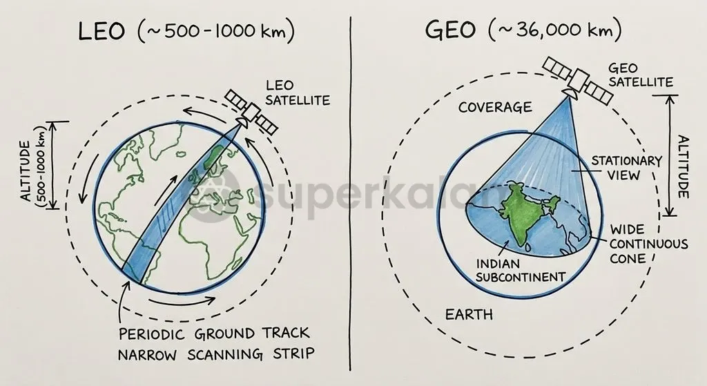
Low Earth Orbit (LEO) satellites travel at altitudes between 500 and 1,000 kilometres, completing an orbit every 90 to 100 minutes. Because of their proximity to Earth, LEO sensors achieve fine sub-metre spatial clarity. However, because the planet rotates beneath the orbital plane, a single LEO spacecraft cannot maintain a continuous view over a given region. This produces a multi-day revisit latency before imaging the exact same location again [The Hindu: Steady gaze - On the launch of ISRO's EOS-05 satellite].
Geosynchronous Orbit (GEO) satellites operate at an altitude of approximately 35,786 kilometres. At this height, their orbital period matches Earth's 24-hour rotational period. A GEO satellite remains fixed over a single meridian, allowing continuous surveillance over an entire hemisphere at the cost of coarser ground resolution.
| Feature | Low Earth Orbit (LEO) Observation | Geosynchronous (GEO) Observation (EOS-05) |
|---|---|---|
| Orbital Altitude | 500 to 1,000 km | ~35,786 km (Geostationary / Geosynchronous) |
| Spatial Resolution | Sub-metre to 5 metres (High spatial detail) | 42 metres (optical) to 1.2 km (thermal) |
| Temporal Cadence | Multi-day revisit cycle (2 to 24 days) | Continuous; refresh every 5 to 30 minutes |
| Geographic Coverage | Global coverage in narrow, moving swaths | Fixed staring footprint over South Asia |
| Primary Use Cases | Urban planning, cadastral mapping, detailed infrastructure analysis | Disaster tracking, real-time tactical awareness, cloudburst monitoring |
Discuss with Superkalam
Explain the fundamental trade-off between spatial resolution and temporal cadence when choosing between LEO and GEO orbits.
Ask NowKey Applications: Real-Time Disaster Management to Border Security
Disaster monitoring agencies require rapid information to coordinate emergency evacuations during sudden meteorological events. EOS-05 provides near-real-time imaging that captures the progressive spread of natural disasters as they unfold [PIB release: Prime Minister lauds ISRO for successful launch of GSLV-F17 carrying EOS-05].
Dynamic environmental applications include:
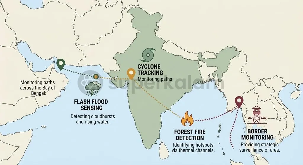
- Cyclonic Tracking: Monitoring the circulation velocity, convective band formation, and landfall progression of tropical cyclones across the Bay of Bengal and the Arabian Sea.
- Cloudbursts and Flash Floods: Tracking rapid convective cloud development over mountainous terrain to issue early warnings for localised flash floods.
- Forest Fire Propagation: Using Long-Wave Infrared channels to detect active thermal anomalies and map the directional spread of forest fires across critical forest belts.
- Precision Agriculture: Utilising hyperspectral bands to track nitrogen uptake, vegetative chlorophyll indices, soil moisture fluctuations, and intra-day stubble burning episodes across northern India [The Hindu: Steady gaze - On the launch of ISRO's EOS-05 satellite].
National security operations benefit from uninterrupted observation over sensitive frontiers. EOS-05 maintains persistent surveillance over the Line of Actual Control (LAC), the Line of Control (LoC), and the northern Indian Ocean Region (IOR) [The Indian Express: New 'eye in the sky': ISRO's EOS-05 satellite settles into geosynchronous orbit]. This assists maritime domain awareness and continuous tracking of major naval vessel movements.
Discuss with Superkalam
How can the 5-to-10 minute sector scan capability of EOS-05 be applied during an active cloudburst or flash flood event in the Himalayas?
Ask NowThe Technical Challenge: Capturing High-Resolution Images from 36,000 km
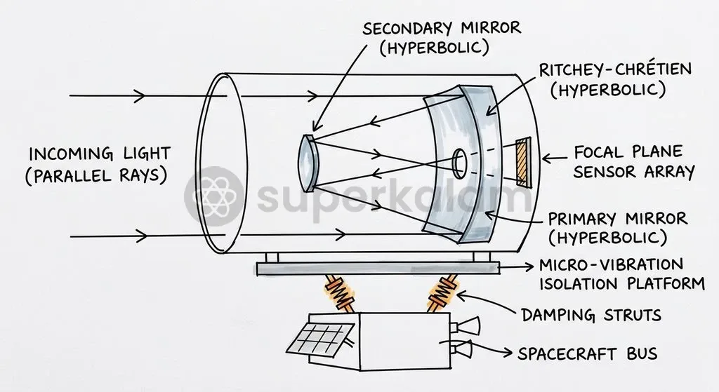
Optical remote sensing from geostationary altitudes requires resolving fine ground features from 50 times farther away than standard LEO orbits. To achieve a 42-metre ground sampling distance from 36,000 kilometres, EOS-05 relies on a 700 mm aperture Ritchey–Chrétien optical telescope designed to maximise photon collection efficiency [ISRO Space Applications Centre Technical Documentation: Large Aperture Optics for High Altitude Remote Sensing].
Satellite engineers must overcome severe physical hurdles to maintain image clarity across such vast distances:
- Extreme Pointing Stability: A pointing deviation of just a few micro-radians causes ground displacement errors spanning hundreds of metres.
- Micro-Vibration Isolation: Mechanical vibrations from onboard reaction wheels, cryocoolers, and solar array drives must be isolated to prevent optical blur [ISRO Satellite Centre (URSC) Technical Review Papers on GEO Imager Jitter and Pointing].
- Thermal Gradient Management: Massive temperature swings between direct solar exposure and Earth's shadow require active optical barrel temperature stabilisation to prevent mirror deformation.
| Country / Agency | Satellite Series | Orbital Type | Visible Resolution | Infrared Resolution | Full-Disk Refresh |
|---|---|---|---|---|---|
| India (ISRO) | EOS-05 | Geosynchronous | 42 metres | 1.2 km (LWIR) | 30 min (5-10 min sector) |
| China (CNSA) | Gaofen-4 | Geostationary | 50 metres | 400 metres (MWIR) | Staring / Sector scan |
| USA (NOAA) | GOES-R (ABI) | Geostationary | 0.5 to 1.0 km | 2.0 km | 5 to 10 minutes |
| Japan (JMA) | Himawari-8/9 | Geostationary | 0.5 to 1.0 km | 2.0 km | 10 minutes |
| Russia (Roscosmos) | Elektro-L | Geostationary | ~1.0 km | ~4.0 km | 15 to 30 minutes |
EOS-05 provides superior optical spatial resolution compared to conventional geostationary meteorological platforms like NOAA's GOES-R and Japan's Himawari-8/9 [NOAA / NESDIS GOES-R Series Advanced Baseline Imager (ABI) Technical Specifications]. Those systems prioritise wide meteorological scanning at 0.5 to 1.0 km resolutions. EOS-05 operates in a high-resolution staring class comparable to China's Gaofen-4, which achieved 50-metre optical resolution following its launch in December 2015 [MDPI Remote Sensing: Comprehensive Evaluation of the GF-4 Satellite Image Quality].
Discuss with Superkalam
Compare the operational utility of hyperspectral SWIR sensors versus thermal LWIR channels in monitoring agricultural stubble burning and forest fires.
Ask NowThe Road Ahead for India's Remote Sensing Capabilities
ISRO's operationalisation of EOS-05 establishes an integrated remote sensing architecture for India. Combining high-cadence geostationary surveillance with high-resolution LEO imaging platforms gives Indian planners both persistent regional situational awareness and detailed target inspection capabilities.
Maximising the utility of EOS-05 data requires establishing automated data pipelines directly linked with user agencies:
- Automated Disaster Alerts: Integrating near-real-time thermal and multispectral telemetry into the National Disaster Management Authority (NDMA) decision support systems to automate flood and cyclone evacuation protocols.
- AI-Driven Edge Analytics: Deploying automated machine-learning models to detect rapid land-cover shifts, border infrastructure buildup, and maritime transit patterns without manual image interpretation.
- Constellation Redundancy: Developing complementary geostationary surveillance payloads to ensure continuous orbital coverage, eliminating single-point satellite vulnerabilities over the Indian Ocean.
Key Takeaways
- Mission Launch: ISRO launched EOS-05 aboard GSLV-F17 on 4 September 2026 into a geosynchronous orbit at 85.5° East longitude with a 7-year design life.
- GISAT Continuation: The satellite represents the operational replacement for GISAT-1 (EOS-03), which failed to reach orbit in August 2021.
- Resolution and Cadence: EOS-05 delivers 42-metre optical spatial resolution and long-wave thermal imaging, scanning all of India every 30 minutes and priority sectors every 5 to 10 minutes.
- LEO vs GEO Trade-Off: The mission prioritises high temporal cadence over sub-metre spatial resolution, filling the temporal observation gap left by low-orbit satellites.
- Strategic and Civic Value: Applications span dynamic disaster monitoring (cyclones, cloudbursts, forest fires) and persistent surveillance along land borders and maritime sea lanes.
Mains Question
"The transition from low-altitude snapshots to continuous geostationary surveillance marks a paradigm shift in Earth observation architecture." In light of the operationalisation of ISRO's EOS-05, elucidate how orbital trade-offs shape satellite utility across disaster risk reduction and national security. (15 Marks)
Evaluate NowMains Question
Evaluate the technical and operational challenges of conducting high-resolution optical remote sensing from geostationary altitudes, with reference to ISRO's EOS-05 payload. (10 Marks)
Evaluate NowPractice MCQs
QUESTION 1
With reference to the EOS-05 satellite launched by ISRO, consider the following statements:
- It is positioned in a Geosynchronous Orbit at 85.5° East longitude.
- It serves as an operational continuation of the Geo Imaging Satellite (GISAT) architecture.
- It carries a Multispectral Long-Wave Infrared (MX-LWIR) payload capable of sub-metre spatial resolution.
Which of the statements given above are correct?
QUESTION 2
Consider the following statements regarding Earth observation orbits:
- Low Earth Orbit (LEO) satellites offer high spatial resolution but have multi-day revisit cycles over a specific location.
- Geostationary Orbit (GEO) observation platforms allow continuous surveillance of an entire hemisphere at the expense of coarser ground resolution.
- The EOS-05 satellite scans the Indian landmass every 30 minutes, with steering capabilities for dynamic sector scans every 5 to 10 minutes.
Which of the statements given above is/are correct?
QUESTION 3
With reference to the sensor suite onboard ISRO's EOS-05 satellite, consider the following pairs:
- Multispectral Visible Near-Infrared (MX-VNIR) : 42-metre spatial resolution
- Hyperspectral Visible Near-Infrared (HyS-VNIR) : 158 spectral channels
- Hyperspectral Short-Wave Infrared (HyS-SWIR) : 256 spectral channels
How many of the pairs given above are correctly matched?
QUESTION 4
Which of the following optical telescope designs is employed by ISRO's EOS-05 satellite to achieve high-resolution optical imaging from geostationary orbit?
QUESTION 5
Consider the following statements regarding the applications of EOS-05:
- Its hyperspectral bands aid in monitoring nitrogen uptake, chlorophyll indices, and stubble burning episodes.
- Its Long-Wave Infrared (LWIR) channels assist in detecting thermal anomalies and mapping forest fire propagation.
- It provides persistent staring surveillance over the Line of Actual Control (LAC) and the northern Indian Ocean Region (IOR).
Which of the statements given above are correct?