Digantara SCOT Mission: Space Situational Awareness Explained
What is Digantara's SCOT mission? Read how space-based optical tracking works, why space situational awareness matters and India's satellite-safety efforts.
Oct, 2026
•8 min read

Overview
India’s commercial orbital surveillance began when Digantara launched its Space Camera for Object Tracking satellite to track small orbital debris from space. This launch marks a decisive shift from ground-tethered tracking toward an autonomous, multi-layered surveillance network.
Space Situational Awareness involves detecting, tracking, and cataloguing artificial objects and natural debris in Earth orbit to prevent catastrophic collisions. Commercial initiatives authorised under the Indian Space Policy 2023 complement the Indian Space Research Organisation's Project NETRA by deploying space-based optical sensors.
These orbital sensors bypass atmospheric distortion, weather attenuation, and geographic radar blind spots to aim to track fragments down to five centimetres, a company-reported capability. Establishing sovereign tracking protects strategic civil satellites, can reduce operational reliance on foreign tracking networks, and provides dual-use surveillance across congested corridors.
Why in the News: Digantara and the SCOT Mission
Digantara launched SCOT aboard SpaceX's Transporter-12 rideshare mission into Sun-Synchronous Orbit on 14 January 2025, deploying India's first commercial space surveillance satellite. As of March 2025, the satellite actively tracks Resident Space Objects down to five centimetres in Low Earth Orbit using space-based optical sensors, according to reporting by The Economic Times.
The mission operationalises private sector participation under the Indian Space Policy - 2023, which explicitly encourages Non-Government Entities to build commercial space situational capabilities. IN-SPACe subsequently formalised these operations by releasing dedicated Norms, Guidelines and Procedures governing private surveillance entities. This institutional backing integrates private sensor networks directly into national aerospace infrastructure.
Discuss with Superkalam
What minimum size of orbital debris can Digantara's SCOT satellite track in Low Earth Orbit?
Ask NowWhat is Space Situational Awareness and Why Does India Need It?
Space Situational Awareness entails tracking, characterising, and understanding all orbital objects to safeguard sustainable spaceflight. The discipline monitors four primary categories of objects:
- Active satellites across low, medium, and geostationary orbits.
- Inactive rocket bodies left behind from historical launches.
- Lethal collision fragments generated by past orbital breakups.
- Near-Earth Objects that pose planetary impact risks.
India’s expanding space economy relies heavily on communication, navigation, and remote sensing constellations that require continuous protection against hypervelocity orbital impacts. In Low Earth Orbit, relative collision velocities average 7 to 10 kilometres per second, meaning a microscopic fragment carries destructive kinetic energy. Even a one-centimetre debris fragment possesses kinetic energy comparable to an exploding grenade, capable of shattering an active operational satellite.
Beyond collision avoidance, orbital tracking sensors support essential planetary defence initiatives. According to an ISRO statement to the United Nations Committee on the Peaceful Uses of Outer Space (UNCOPUOS), space surveillance sensors calculate precise orbital ephemerides for Near-Earth Objects and monitor solar space weather events capable of damaging critical orbital electronics or terrestrial electrical grids.
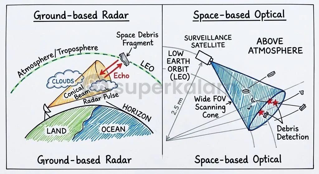
How SCOT Works: In-Orbit Optical Sensors vs Ground-Based Radars
The SCOT spacecraft uses space-based optical telescopes to observe Resident Space Objects against the dark celestial backdrop of space, eliminating major terrestrial atmospheric constraints. Traditional space surveillance networks depend on ground-based radars and terrestrial optical telescopes, which face significant physical operating limits.
Ground-based radars experience signal attenuation caused by atmospheric moisture, requiring vast electrical power to detect small targets at high altitudes. Terrestrial optical telescopes require clear, cloudless night skies and face severe constraints from daylight and atmospheric turbulence. Placing optical sensors directly in Sun-Synchronous Orbit enables continuous illumination geometries and eliminates local weather disruptions.
| Dimension | Ground-Based Radar Networks | In-Orbit Optical Tracking (SCOT) |
|---|---|---|
| Primary Sensor Type | Radio-frequency phased-array and dish radars | Space-qualified high-resolution optical cameras |
| Atmospheric Vulnerability | Subject to weather attenuation and signal loss | Operates above the atmosphere with zero weather downtime |
| Geographic Coverage | Constrained by sovereign territorial borders | Global orbital coverage across Sun-Synchronous paths |
| Minimum Debris Resolution | Tracks objects roughly 10 centimetres and larger | Resolves orbital fragments down to 5 centimetres |
| Operational Limitations | High power consumption; geographic radar blind spots | High initial launch cost; finite spacecraft operational lifespan |
Data generated by in-orbit optical platforms feeds directly into advanced orbital propagation models. Digantara reported integrating data from its orbital sensor with its proprietary Space-Mission Assurance Platform to provide real-time conjunction warnings and orbit determination services, as reported on 14 January 2025.
Discuss with Superkalam
How does placing optical sensors in Sun-Synchronous Orbit circumvent the operational limitations faced by terrestrial radars?
Ask NowThe Growing Hazard of Orbital Debris and Mega-Constellations
The rapid deployment of commercial satellite mega-constellations in Low Earth Orbit has intensified orbital congestion and collision probabilities across critical altitudes. Thousands of operational satellites now share narrow orbital corridors with abandoned rocket stages and fragments from past collisions.
This crowding accelerates the risk of the Kessler Syndrome, a scenario formulated by NASA astrophysicist Donald J. Kessler in 1978. The model demonstrates that once orbital object density crosses a critical threshold, accidental collisions generate cascades of secondary fragments, triggering self-propagating collisions that render specific orbital bands completely unusable.
To counter this cascading threat, multilateral bodies and national agencies have established strict mitigation targets:
- The 25-Year De-orbit Guideline: The Inter-Agency Space Debris Coordination Committee, where ISRO represents India, established mitigation guidelines recommending that satellites de-orbit within 25 years post-mission.
- Debris Free Space Missions 2030: ISRO introduced the Debris Free Space Missions initiative at the 42nd IADC Annual Meet in April 2024, committing Indian governmental and commercial space actors to achieve debris-free missions by 2030.

India's Sovereign Tracking Push: Project NETRA Meets Private Spacetech
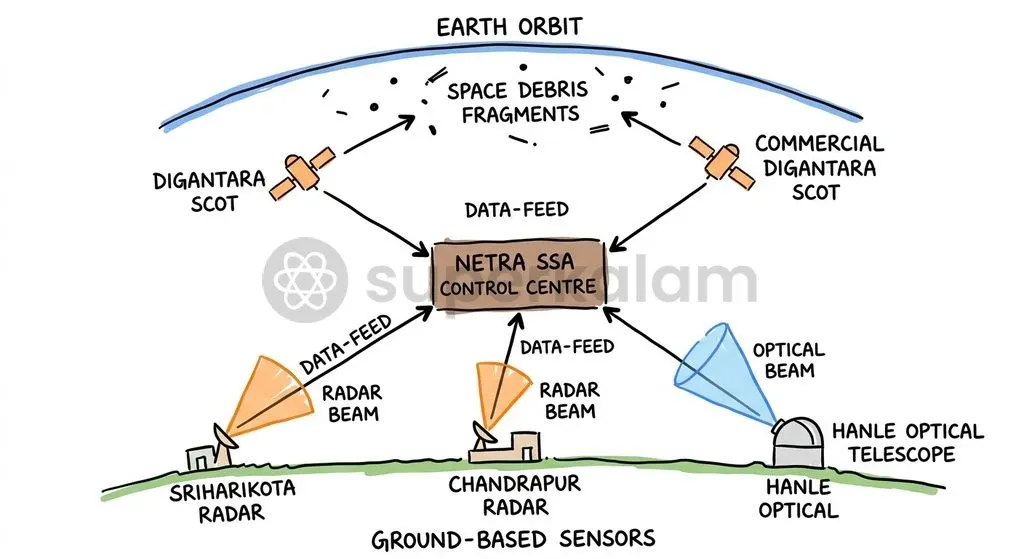
Project NETRA represents ISRO's indigenous ground-based surveillance network designed to monitor, track, and protect India's operational space assets independently. The network integrates optical observation stations, deep-space radars, and a dedicated control centre to generate autonomous conjunction warnings.
Ground installations under Project NETRA combine diverse sensor technologies situated across strategic national locations:
- Multi-Object Tracking Radar: Deployed at Sriharikota for high-precision tracking.
- Specialised Phased-Array Radar: Positioned at Chandrapur in Assam to track debris fragments.
- High-Altitude Optical Telescopes: Operating at Hanle in Ladakh for deep-space surveillance.
Historically, Indian satellite operators depended heavily on public conjunction data provided by the United States Space Command catalogue. Relying on external tracking networks poses strategic vulnerabilities during geopolitical tensions, when foreign operators could restrict access to critical tracking streams. Integrating private commercial constellations like SCOT alongside ISRO’s terrestrial radars creates an autonomous tracking shield.
Discuss with Superkalam
Compare the civil safety objectives of Space Situational Awareness with the strategic objectives of Space Domain Awareness.
Ask NowStrategic and Security Dimensions: Space Defense and Surveillance
Space Domain Awareness extends basic civil safety tracking by adding military threat detection, intent characterisation, and counter-space defence monitoring. While civil tracking prevents accidental collisions, military surveillance monitors adversarial activity across contested orbits.
According to the United Nations Institute for Disarmament Research, traditional Space Situational Awareness focuses on scientific orbital positions, whereas Space Domain Awareness identifies hostile manoeuvres, rendezvous proximity operations, and potential orbital weapons. Dual-use space surveillance technologies provide intelligence on foreign anti-satellite weapon preparations and verify peaceful compliance with international outer space treaties.
Commercial space surveillance constellations reinforce defence operations through two critical capabilities:
- High-Revisit Tracking: Providing orbital revisit rates that sovereign ground-based networks cannot sustain alone.
- Early Co-Orbital Warning: Identifying spacecraft executing co-orbital approaches toward Indian defence satellites to neutralise unannounced interference.
Way Forward: Towards an Autonomous Multi-Layer Space Shield
Building an autonomous multi-layer space shield requires fusing state-run ground tracking infrastructure with private orbital sensor constellations. Ground-based phased-array radars and space-based optical platforms provide complementary tracking angles, eliminating geographic blind spots and minimizing atmospheric interference.
Long-term space preservation requires concerted action across technical, regulatory, and international domains:
- Establishing Sensor Fusion Architectures: Institutionalise automated data-sharing pipelines linking ISRO’s Project NETRA ground sensors with private commercial constellations like Digantara to build an integrated space operating picture.
- Enforcing Debris Mitigation Standards: Operationalise the IN-SPACe regulatory guidelines to ensure all domestic launches adhere strictly to the 2030 Debris Free Space Missions framework, mandating active de-orbiting subsystems.
- Expanding Diplomatic Coalitions: Deepen technical coordination within the Inter-Agency Space Debris Coordination Committee and United Nations forums to codify legally binding space traffic management standards.
- Advancing Active Debris Removal: Invest in indigenous capture technologies, such as robotic arms and electrodynamic tethers, to actively de-orbit non-functional rocket bodies from crowded orbital regimes.
Discuss with Superkalam
Design a regulatory roadmap under IN-SPACe to ensure that Indian private satellite operators comply with the Debris Free Space Missions 2030 mandate.
Ask NowKey Takeaways
- Digantara launched the SCOT satellite on 14 January 2025 via SpaceX Transporter-12, deploying India's first commercial space-based optical sensor to track orbital debris down to five centimetres.
- Space-based optical monitoring bypasses terrestrial radar limitations, including atmospheric attenuation, cloud interference, and national geographic blind spots.
- In Low Earth Orbit, relative collision velocities reach 7 to 10 kilometres per second, enabling even a one-centimetre fragment to cause catastrophic structural failure to operational satellites.
- ISRO’s Project NETRA operates indigenous ground radars and optical telescopes, decreasing strategic dependence on external sources such as the United States Space Command catalog.
- Under the Debris Free Space Missions roadmap adopted in 2024, India targets debris-free operations across all public and private missions by 2030, reinforcing global standards set by the Inter-Agency Space Debris Coordination Committee.
Mains Question
"Relying on external tracking catalogues poses strategic vulnerabilities during geopolitical tensions." In light of this statement, examine how the integration of private in-orbit surveillance initiatives with ISRO's Project NETRA strengthens India's sovereign space defence. (10 Marks)
Evaluate NowMains Question
The escalating density of commercial mega-constellations in Low Earth Orbit threatens to trigger the Kessler Syndrome, jeopardising sustainable space operations. Evaluate the efficacy of current domestic and multilateral regulatory frameworks in ensuring orbital sustainability. (15 Marks)
Evaluate NowPractice MCQs
QUESTION 1
With reference to Space Situational Awareness (SSA) and in-orbit tracking, consider the following statements:
- Space-based optical sensors can resolve debris fragments smaller than those typically detected by traditional ground-based radar networks.
- In-orbit optical tracking operates free from atmospheric weather attenuation and daylight constraints.
- Digantara's SCOT satellite was deployed into Sun-Synchronous Orbit to monitor Resident Space Objects. Which of the statements given above are correct?
QUESTION 2
Consider the following statements regarding ISRO's Project NETRA:
- It is an indigenous space surveillance network designed to generate sovereign conjunction warnings.
- It integrates a Multi-Object Tracking Radar deployed at Sriharikota with a specialised phased-array radar at Chandrapur in Assam.
- It relies exclusively on space-based optical sensors deployed in geostationary orbit. Which of the statements given above is/are correct?
QUESTION 3
Consider the following statements regarding orbital debris mitigation guidelines and initiatives:
- The Inter-Agency Space Debris Coordination Committee recommends that satellites de-orbit within 25 years post-mission.
- ISRO committed Indian space actors to achieve debris-free missions by 2030 under the Debris Free Space Missions initiative.
- The Kessler Syndrome refers to a runaway cascade where collisions between orbital objects generate secondary debris, rendering orbital bands unusable. Which of the statements given above are correct?
QUESTION 4
With reference to the strategic distinction between Space Situational Awareness (SSA) and Space Domain Awareness (SDA), consider the following statements:
- Traditional SSA concentrates primarily on civil safety, orbital tracking, and scientific positioning of space objects.
- SDA incorporates military surveillance to detect adversarial manoeuvres, rendezvous proximity operations, and orbital weapons. Which of the statements given above is/are correct?
QUESTION 5
Which regulatory entity released dedicated Norms, Guidelines and Procedures governing private space situational awareness entities under the Indian Space Policy 2023?