Bab el-Mandeb Strait: Location, Map and Importance
Bab el-Mandeb connects the Red Sea and Gulf of Aden. Read its location, bordering countries and importance for shipping, energy and UPSC maps.
Oct, 2026
•8 min read
Overview
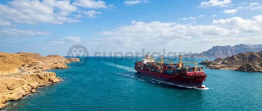
The Bab el-Mandeb Strait is a vital maritime chokepoint connecting the Red Sea to the Gulf of Aden and the Indian Ocean. It anchors the shortest shipping route between Asia and Europe through the Suez Canal.
Geopolitical instability and asymmetric security threats along this narrow corridor have forced commercial vessels to reroute around southern Africa. This shift has driven up freight inflation, pushed insurance premiums higher, and lengthened global transit times.
Grasping the strategic geography of Bab el-Mandeb is central to evaluating supply chain resilience. It also frames India's role as a net security provider in the Western Indian Ocean.
Why is the Bab el-Mandeb Strait in the News?
The Bab el-Mandeb Strait returned to international headlines following repeated drone and missile strikes by Yemen's Houthi movement against commercial shipping.
Maritime insurance syndicates responded by categorising the southern Red Sea as a High-Risk Area, according to the UNCTAD Review of Maritime Transport. This designation drove Hull and Machinery War Risk Premiums from below 0.1% to upwards of 0.7% to 1.0% of vessel value during peak escalation periods.
These heightened risks forced major shipping lines to divert container carriers and oil tankers away from the Suez corridor. As of March 2026, the ongoing instability highlights how asymmetric attacks at narrow choke points can disrupt international energy markets and manufacturing supply chains.
Discuss with Superkalam
Which littoral states border the Bab el-Mandeb Strait, and which island divides its primary navigational channels?
Ask NowGeographical Location and Bordering Littoral Countries
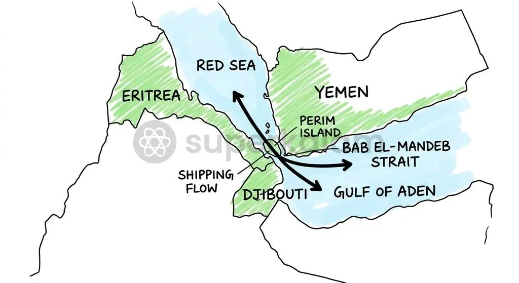
The Bab el-Mandeb Strait forms the narrow southern maritime gateway between the Arabian Peninsula and the Horn of Africa.
According to the OECD Maritime Transportation Disruptions Report, the strait is bounded by Yemen to the northeast and by Djibouti and Eritrea on the African continent to the southwest. It connects the Red Sea with the Gulf of Aden, which opens into the Arabian Sea and the wider Indian Ocean.
Data from the UNCTAD Review of Maritime Transport shows that the strait spans approximately 26 to 32 kilometres at its narrowest passage between Ras Menheli in Yemen and Ras Siyyan in Djibouti.
Yemen-controlled Perim Island (also known as Mayyun) divides the Bab el-Mandeb Strait into two distinct navigational channels:
- Bab Iskender (Eastern Channel): A narrow, shallow passage roughly 3 kilometres wide, used primarily by small craft and local coastal vessels.
- Dact-el-Mayyun (Western Channel): A deep-water channel roughly 25 kilometres wide that carries almost all deep-draft international commercial cargo vessels and oil supertankers.
How Bab el-Mandeb Connects Global Trade: The Suez Canal Lifeline
The Bab el-Mandeb Strait is an indispensable conduit sustaining maritime commerce across global waters.
Key trade and hydrocarbon flows passing through the strait demonstrate its commercial significance:
- Global Merchandise Share: The corridor historically handled roughly 10% to 12% of global seaborne trade and approximately 15% of global container traffic prior to major security escalations, linking East Asian industrial hubs directly to European and North American consumer markets, according to the UNCTAD Review of Maritime Transport.
- Hydrocarbon Baseline (2023): Crude oil and petroleum liquids moving through Bab el-Mandeb stood at 9.3 million barrels per day in 2023, sourced from the U.S. Energy Information Administration (EIA) Short-Term Energy Outlook & Chokepoint Analysis.
- Flow Contraction (2024–2025): Escalating hostilities caused these flows to drop sharply to 4.1 million barrels per day in 2024 and 4.2 million barrels per day in the first half of 2025.
This steep decline reflects how rapidly regional maritime conflict can redirect international energy trade.
Discuss with Superkalam
How do asymmetric attacks by non-state actors using drones and missiles undermine the principle of transit passage under UNCLOS?
Ask NowStrategic Chokepoint Vulnerabilities: Piracy, Regional Conflicts, and Houthi Attacks
The Bab el-Mandeb Strait faces severe geostrategic vulnerabilities stemming from state fragility, contested maritime control, and asymmetric warfare.
Political instability in Yemen gave the Houthi movement geographic proximity to strike vessels in the western channel. Non-state groups have disrupted commercial navigation by deploying anti-ship ballistic missiles, aerial drones, and uncrewed surface vessels without maintaining a conventional navy.
Maritime security challenges across the Horn of Africa, including Somali piracy and regional civil conflicts, add further complexity to the Gulf of Aden:
- Transit Rights Under Strain: Under the United Nations Convention on the Law of the Sea (UNCLOS), the right of transit passage applies to international straits, yet non-state actors ignore international legal frameworks.
- Operational Trade-offs: The unpredictability of attacks forces commercial operators to choose between war-risk exposure and costly logistical detours.
Alternative Maritime Routes: Cape of Good Hope vs Bab el-Mandeb
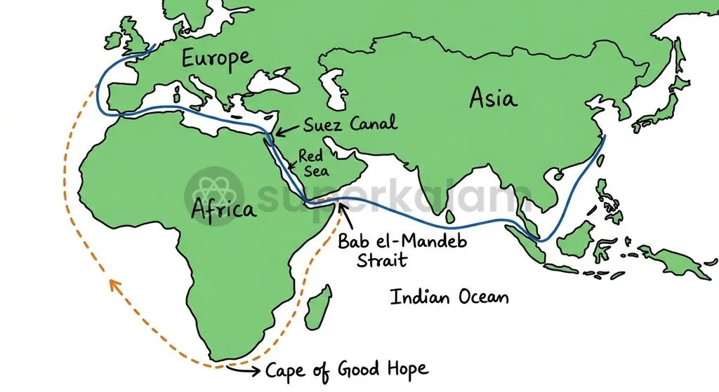
Persistent security threats at Bab el-Mandeb have driven shipping lines to reroute vessels around the southern tip of Africa.
The journey around the Cape of Good Hope bypasses the Red Sea entirely, offering safety at the cost of operational efficiency. Sourced from the U.S. Energy Information Administration (EIA) Chokepoint Data, diverted crude oil and petroleum liquids around the Cape of Good Hope climbed from 6.2 million barrels per day in 2023 to 9.3 million barrels per day in 2024, remaining at 9.1 million barrels per day in the first half of 2025.
| Comparative Dimension | Bab el-Mandeb & Suez Route | Cape of Good Hope Route |
|---|---|---|
| Geographic Pathway | Red Sea → Suez Canal → Mediterranean Sea | South Atlantic Ocean → Southern Indian Ocean |
| Transit Distance (Asia to Northern Europe) | Direct shortest route | Adds 3,000 to 4,000 nautical miles |
| Transit Time | Standard scheduled transit | Adds 10 to 15 additional days |
| Bunker Fuel & Emissions | Baseline fuel consumption | Increases fuel use and emissions by 30% to 40% |
| Security Risk Profile | Missile strikes, drone attacks, war-risk surcharges | Navigational rough seas, extended turnaround delays |
| Daily Oil Flow Trend (2023 vs 2024) | Dropped from 9.3 to 4.1 million bpd | Rose from 6.2 to 9.3 million bpd |
This widespread rerouting causes ripple effects across global logistics. Longer voyages tie up container capacity, creating equipment shortages at key ports and driving up benchmark freight rates.
Discuss with Superkalam
If a shipping company must move containerized goods from Mumbai to Rotterdam, how should it calculate the cost trade-offs between War Risk Premiums in Bab el-Mandeb versus the extended transit fuel costs around the Cape of Good Hope?
Ask NowWhat the Disruption Means for India's Trade and Energy Security
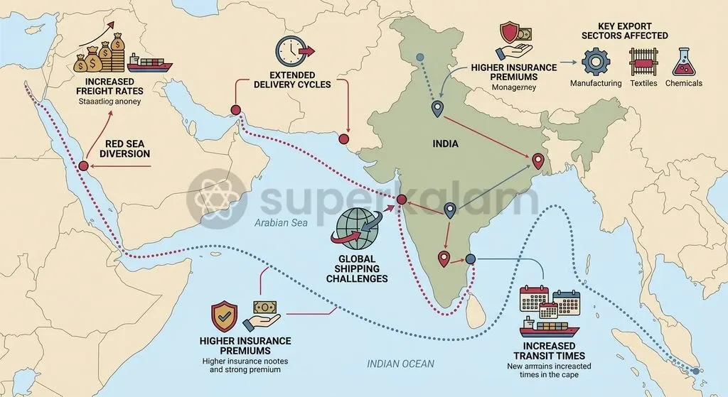
Disruptions along the Bab el-Mandeb corridor put direct pressure on India's external trade balance and export competitiveness.
According to the Economic Survey 2023-24, over 50% of India's total merchandise exports by value destined for the European Union, the United Kingdom, and the East Coast of the United States traditionally transit through the Bab el-Mandeb Strait. Key Indian export sectors with tight margins—including textiles, agricultural goods, engineering items, and gems and jewellery—face cost surges from rising freight rates and delayed shipments.
Energy imports and refined product exports face logistical hurdles:
- Refined Petroleum Exports: While crude imports from the Persian Gulf transit the Strait of Hormuz, India's refined petroleum exports heading west face higher freight costs, squeezing refining margins.
- Working Capital Pressures: Prolonged voyage durations force Indian exporters to hold higher buffer inventories, locking up working capital and slowing overall trade velocity.
India's Maritime Strategy: Operation Sankalp and Indian Ocean Diplomacy
The Indian Navy has reinforced its presence in the Western Indian Ocean to protect national commercial interests and uphold the maritime rules-based order.
Under Operation Sankalp, the Indian Navy conducts sustained deterrence patrols across the Arabian Sea, the Gulf of Aden, and the approaches to the Strait of Hormuz. According to the Press Information Bureau (PIB), Ministry of Defence, the Indian Navy deployed over 21 warships, logged more than 450 ship days and 900 flight hours, and responded to 18 maritime distress incidents during a dedicated 100-day enhanced operational phase following Red Sea escalations.
Key pillars of India's Western Indian Ocean security posture include:
- Escort Operations: Providing direct protection and surveillance for Indian-flagged merchant vessels.
- Strategic Autonomy: Operating independently under Operation Sankalp rather than joining US-led multilateral task forces like Operation Prosperity Guardian.
- First-Responder Role: Delivering rapid boarding, medical aid, and anti-piracy assistance to foreign merchant vessels in distress.
This operational presence strengthens India's standing as a dependable security partner across the Indian Ocean Region (IOR).
Discuss with Superkalam
Analyse why disruption in the Bab el-Mandeb Strait has a more acute impact on India's export balance compared to its crude oil import flows.
Ask NowWay Forward: Securing Critical Sea Lines of Communication (SLOCs)
Protecting international waterways against asymmetric threats requires multilateral coordination, sensor integration, and diversified trade corridors.
- Strengthening Rules-Based Order: International maritime authorities, guided by the International Maritime Organization (IMO) and UNCLOS, must deepen coordinated information-sharing mechanisms to suppress maritime piracy and unprovoked attacks on neutral merchant vessels.
- Multilateral Maritime Domain Awareness: Coastal states and regional security frameworks should enhance real-time sensor integration to detect uncrewed surface and aerial threats across strategic choke points.
- Developing Alternative Transport Corridors: Accelerating multi-modal connectivity projects—such as the India-Middle East-Europe Economic Corridor (IMEC) and the International North-South Transport Corridor (INSTC)—provides strategic resilience against physical chokepoint closures.
- Sustaining Naval Capabilities: India must continue investing in long-range maritime surveillance aircraft, guided-missile destroyers, and forward logistical basing to maintain stable deterrence across the Western Indian Ocean.
Key Takeaways
- The Bab el-Mandeb Strait is a strategic chokepoint linking the Red Sea to the Gulf of Aden, bordered by Yemen to the northeast and Djibouti and Eritrea to the southwest.
- Yemen's Perim Island (Mayyun) splits the strait into the shallow eastern Bab Iskender and the deep-water western Dact-el-Mayyun channel.
- The corridor historically handled 10% to 12% of global seaborne merchandise trade and 15% of maritime container volumes before major security disruptions.
- Crude oil and petroleum liquid transits fell from 9.3 million barrels per day in 2023 to 4.1 million barrels per day in 2024 due to vessel rerouting around the Cape of Good Hope.
- Diverting ships around southern Africa adds 3,000 to 4,000 nautical miles, extends voyage times by 10 to 15 days, and increases bunker fuel consumption and emissions by 30% to 40%.
- Over 50% of India's merchandise exports to Europe and the US East Coast rely on this route; the Indian Navy conducts Operation Sankalp as an independent maritime security effort in response.
Mains Question
"With over 50% of India's merchandise exports to Western markets transiting the Red Sea corridor, security disruptions at the Bab el-Mandeb Strait have exposed critical supply chain vulnerabilities." Examine the economic implications of this chokepoint disruption for India. (10 Marks)
Evaluate NowMains Question
"The rise of asymmetric warfare by non-state actors along strategic maritime chokepoints presents complex challenges to the international law of the sea and global trade security." In this context, critically analyse India's naval posture and strategic choices under Operation Sankalp. (15 Marks)
Evaluate NowPractice MCQs
QUESTION 1
With reference to the geographical location and maritime features of the Bab el-Mandeb Strait, consider the following statements:
- It connects the Red Sea with the Gulf of Aden.
- It is bounded by Yemen to the northeast and by Djibouti and Eritrea to the southwest.
- Yemen-controlled Perim Island divides the strait into the shallow Bab Iskender channel and the deep-water Dact-el-Mayyun channel.
Which of the statements given above are correct?
QUESTION 2
Consider the following statements comparing the Bab el-Mandeb/Suez maritime route with the Cape of Good Hope alternative:
- Rerouting via the Cape of Good Hope adds approximately 3,000 to 4,000 nautical miles for voyages between Asia and Northern Europe.
- Diverting around the southern tip of Africa increases vessel bunker fuel use and carbon emissions by 30% to 40%.
- Daily flows of crude oil and petroleum liquids through Bab el-Mandeb increased between 2023 and 2024 as shipping lines sought deeper waters.
Which of the statements given above is/are correct?
QUESTION 3
Regarding the economic and strategic implications of the Bab el-Mandeb disruption for India, consider the following statements:
- Over 50% of India's total merchandise exports destined for the EU, UK, and East Coast of the US traditionally transit through the Bab el-Mandeb Strait.
- Under Operation Sankalp, the Indian Navy integrated its naval combatants directly into the US-led Operation Prosperity Guardian task force.
- Prolonged voyage durations force Indian exporters in margin-sensitive sectors to hold higher buffer inventories, tying up working capital.
Which of the statements given above is/are correct?
QUESTION 4
Consider the following statements regarding navigational channels in the Bab el-Mandeb Strait:
- Bab Iskender is the western deep-water channel used by international oil supertankers.
- Dact-el-Mayyun is the eastern shallow channel spanning roughly 3 kilometres in width.
Which of the statements given above is/are correct?
QUESTION 5
In the context of maritime security in the Western Indian Ocean, what is the primary operational objective of India's 'Operation Sankalp'?