Aravalli Hills Definition: Why Morphological Criteria Fail Ecology
As the Supreme Court pauses its 100-metre relief rule, the debate exposes how rigid morphological yardsticks fail the ancient Aravalli ecological buffer.
Sep, 2026
•9 min read
Overview
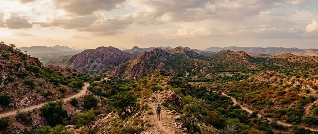
Delineating the Aravalli Range purely by rigid morphological thresholds fails ecological conservation. A 100-metre elevation cutoff systematically excludes low-lying ridges, piedmont recharge zones, and vital wildlife corridors from statutory environmental protection.
The Aravallis are an ancient, heavily weathered mountain system. Their functional integrity depends on continuous hydrological networks and biodiversity connectivity rather than steep vertical relief.
Defining hills through isolated geometric criteria enables real estate encroachment and commercial mining in ecologically vulnerable foothills. This accelerates groundwater depletion across Delhi-NCR and permits the eastward march of the Thar Desert.
Why in the News: The Dispute Over Defining the Aravalli Hills
The Supreme Court of India stayed its earlier ruling on 29 December 2025 regarding a uniform definition of the Aravalli Hills. The Court had initially approved an administrative definition on 20 November 2025.
That earlier formula introduced two rigid geometric baselines:
- Elevation Threshold: Classifying landforms rising 100 metres or more above local relief as Aravalli Hills.
- Contiguity Distance: Grouping landforms within 500 metres into unified ranges.
Widespread concern from conservation scientists and civil society prompted judicial reconsideration. Legal experts highlighted that a strict 100-metre elevation benchmark threatened to exclude extensive low-lying hill systems across Haryana, Rajasthan, and Gujarat from legal protection.
The central thesis of the ongoing debate is clear. Protecting ecological integrity requires a landscape-level approach, whereas applying arbitrary geometric metrics opens critical terrain to irreversible degradation.
Discuss with Superkalam
Which four states and Union Territories are spanned by the 690-kilometre corridor of the Aravalli Range?
Ask NowUnderstanding the Aravalli Range: Geography, Age, and Ecological Role
The Aravalli Range forms one of the planet's oldest fold mountain systems, dating to the Proterozoic Era nearly two billion years ago. The range spans over 690 kilometres, running south-west to north-east across Gujarat, Rajasthan, Haryana, and the National Capital Territory of Delhi.
Millions of years of natural weathering and tectonic stability have eroded these once massive peaks into low rolling hills, pediments, and rocky outcrops.
The range spans four distinct administrative territories along its 690-kilometre corridor:
- Gujarat: Forms the southern anchor of the mountain system.
- Rajasthan: Encompasses the central core and major intermontane wind gaps.
- Haryana: Encompasses extensive piedmont and groundwater recharge zones.
- Delhi (NCR): Represents the northern terminus via the Delhi Ridge.
The geological architecture of the range makes it an indispensable environmental barrier for northern India:
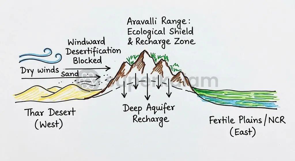
- Desertification Check: The range is a green wall against the eastward expansion of the Thar Desert, protecting fertile agricultural tracts across eastern Rajasthan, Haryana, western Uttar Pradesh, and the Indo-Gangetic plains.
- Regional Groundwater Bank: The fractured quartzite formations and secondary rock porosity allow precipitation to percolate deep underground, yielding an estimated aquifer recharge capacity of up to 2 million litres per hectare annually.
- Climate and Dust Regulation: The hills interrupt western dust storms and moderate regional climate patterns across the densely populated National Capital Region (NCR).
How the Aravallis are Currently Defined: Slope, Elevation, and Contiguity Rules
Administrative attempts to demarcate the Aravallis have historically relied on geometric cutoffs rather than continuous ecological mapping.
Current demarcation rules rest on three fragmented administrative mechanisms:
- FSI Morphological Criteria: In earlier assessments submitted to the Supreme Court, the Forest Survey of India (FSI) utilised slope criteria combined with foothill buffer areas and inter-hill contiguity distances to map hillocks.
- Archaic Revenue Classifications: State revenue departments classify these landforms under land records using labels like Gair Mumkin Pahar (uncultivable rocky hill) or Banjar (barren land). Because these classifications govern land-use rights, unnotified parcels face constant targeting for real estate conversion and commercial quarrying.
- State Forest Thresholds: In August 2025, the Haryana government notified criteria for identifying "forest as per dictionary meaning," requiring a minimum 40% canopy density over at least 5 hectares (or 2 hectares if contiguous).
Environmentalists point out that such high canopy thresholds disregard the natural open-scrub and dry thorn vegetation native to the Aravalli landscape.
Discuss with Superkalam
How does the physical weathering of the Proterozoic Aravalli Range make a rigid 100-metre height cutoff ecologically inappropriate?
Ask NowWhy Morphological Criteria Fall Short of True Ecological Protection
Uniform morphological standards fail the Aravalli ecosystem. Ecological functions operate across continuous watersheds rather than isolated topographic peaks.
Imposing an arbitrary 100-metre relief threshold discards millions of years of natural denudation. It effectively declares heavily eroded landforms legally invisible.
| Zone Type | Morphological Classification | Ecological Risk if Excluded |
|---|---|---|
| Peaks (≥ 100m) | Protected hill system | Isolated protection without contiguous buffers |
| Pediments & Piedmonts | Excluded as plain land | Vulnerable to quarrying and real estate paving |
| Intermontane Gaps | Excluded non-hill terrain | Creates pathways for desertification drift |
| Fractured Aquifers | Unregulated sub-surface zone | Triggers groundwater collapse across NCR |
Morphological criteria create severe conservation vulnerabilities across three core dimensions:
- Exclusion of Piedmont and Pediment Zones: Low-lying hillocks, pediments (gently sloping rocky surfaces), and piedmont areas (plains lying at the foot of mountains) facilitate maximum rainwater infiltration into regional aquifers. Excluding them leaves vital recharge zones open to paved construction.
- Creation of Desertification Gaps: Aeolian sand from the Thar Desert enters northern plains primarily through gaps and low saddles between ridges; stripping these low passes of legal protection accelerates land degradation.
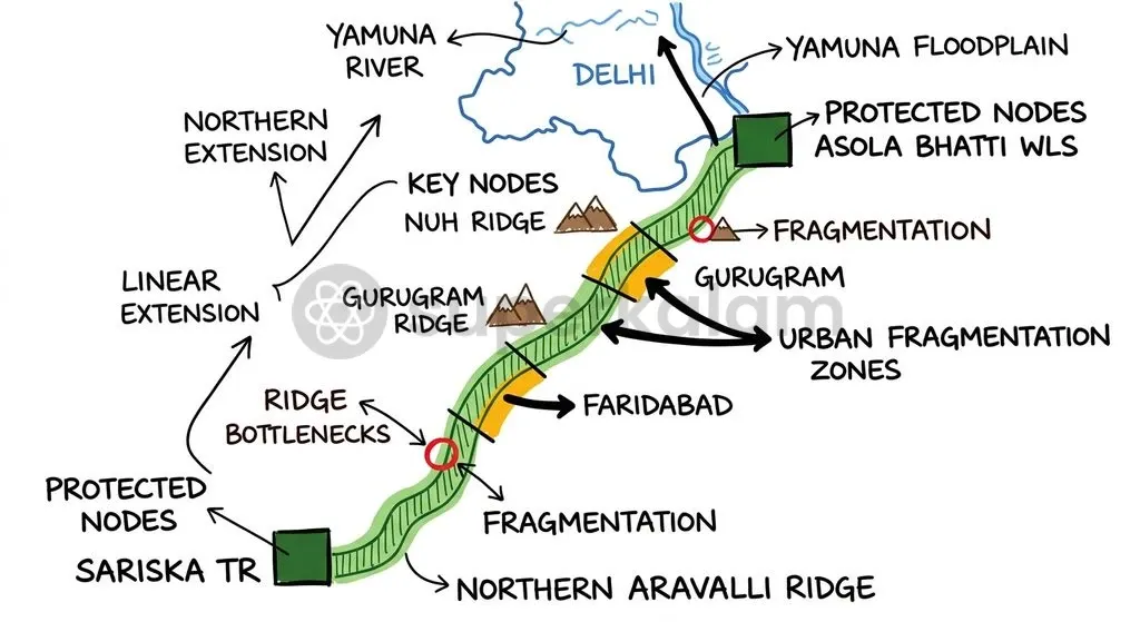
- Severance of Wildlife Corridors: Contiguity thresholds ignore the dispersal requirements of apex predators, fragmenting the critical Northern Aravalli Leopard Corridor that links Sariska Tiger Reserve to the Delhi Ridge.
Comparison: Administrative Boundaries vs. Ecological Landscape Needs
State revenue classifications often diverge sharply from the functional hydrological and ecological realities of the Aravalli landscape.
| Parameter | Administrative/Morphological Approach | Integrated Ecological Approach |
|---|---|---|
| Primary Metric | Height (e.g., 100m cutoff) and slope thresholds | Catchment geomorphology and drainage continuity |
| Piedmont & Foothills | Treated as plain land suitable for development | Protected as primary aquifer recharge zones |
| Forest Classification | Dependent on statutory notification or 40% canopy | Covers open scrub under broad dictionary meaning |
| Wildlife Connectivity | Fragmented by property and revenue boundaries | Preserves contiguous regional movement corridors |
| Conservation Goal | Regulating discrete commercial leases | Securing holistic regional landscape resilience |
Discuss with Superkalam
Analyze how the exclusion of piedmonts and intermontane gaps impacts both regional water security and desertification in the Indo-Gangetic plains.
Ask NowKey Supreme Court Judgments on Aravalli Conservation and Forest Definitions
The Supreme Court of India has repeatedly intervened through landmark environmental rulings to halt uncontrolled mining across the fragile Aravalli terrain.
Key judicial milestones governing the Aravalli Range include:
- The Godavarman Precedent (1996): In the historic T.N. Godavarman Thirumulpad v. Union of India (1996) ruling, the Court held that the word "forest" under Section 2 of the Forest (Conservation) Act, 1980 must be interpreted according to its dictionary meaning. This established that statutory protection extends to all forested tracts regardless of land ownership or formal revenue notification.
- Curbing Illegal Quarrying (2002–2009): In the M.C. Mehta line of cases between 2002 and 2009, the Court clamped down on extensive illegal stone crushing and mining across Faridabad, Gurugram, and Mewat.
- Vanishing Hills Documentation: A detailed report by the Supreme Court-appointed Central Empowered Committee (CEC) revealed that 31 out of 128 sampled hills in Rajasthan had completely vanished over five decades due to unregulated quarrying.
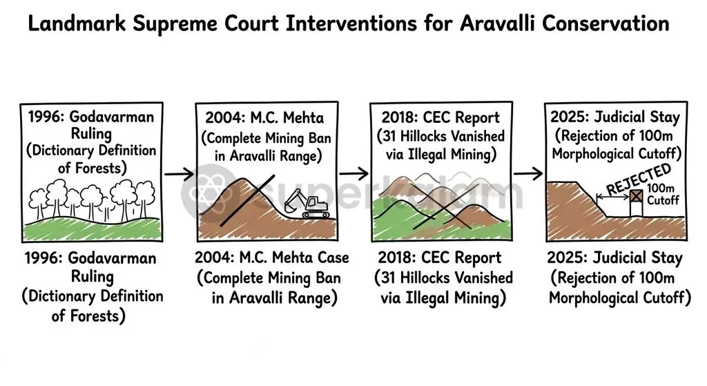
To prevent piecemeal exploitation, the Supreme Court mandated that no new mining leases shall be granted across the entire range until the Ministry of Environment, Forest and Climate Change finalises a comprehensive Management Plan for Sustainable Mining (MPSM) via the Indian Council of Forestry Research and Education (ICFRE).
Environmental Fallout: Desertification, Groundwater Depletion, and Habitat Loss
The ongoing degradation of the Aravalli Range causes compounding environmental stress across northwest India:
- Accelerated Desertification: Unregulated mining and urbanisation destroy the natural topography that holds back airborne sand from Rajasthan, threatening agricultural productivity across Haryana and the Indo-Gangetic plains.
- Severe Groundwater Depletion: Groundwater tables across southern Haryana and Delhi have registered alarming declines due to the destruction of fractured quartzite recharge zones.
- Habitat Fragmentation and Conflict: The fragmentation of forested tracts between Sariska Tiger Reserve in Rajasthan and the Asola Bhatti Wildlife Sanctuary in Delhi causes frequent human-wildlife conflict and isolates resident leopard populations.
Ethical Dimensions: Intergenerational Equity vs Short-Term Real Estate Demands
Environmental governance in the Aravalli belt reflects an intense ethical clash between constitutional intergenerational equity and rapid commercial exploitation. Sustainable governance is anchored in constitutional obligations:
- Article 21: The fundamental right to life, which the higher judiciary has consistently interpreted to include the right to a clean, healthy, and pollution-free environment.
- Article 48A: A non-justiciable Directive Principle instructing the State to protect and improve the natural environment and safeguard forests and wildlife.
- Article 51A(g): A Fundamental Duty obliging every citizen to preserve the natural environment, including forests, lakes, rivers, and wildlife.
In M.C. Mehta v. Kamal Nath (1997), the Supreme Court enunciated the Public Trust Doctrine, holding that certain common environmental resources are held by the state in sacred trust for the public and future generations. Sacrificing ancient mountain catchments for immediate real estate revenues directly violates this doctrine by imposing severe ecological deficits on future generations.
Discuss with Superkalam
Evaluate whether state forest definitions based on high canopy density (such as 40%) adequately protect open-scrub ecosystems.
Ask NowWay Forward: Moving Towards an Integrated Landscape-Level Conservation Framework
Conserving the Aravalli belt requires shifting from arbitrary geometric boundaries toward remote-sensing-backed landscape governance and unified regional planning. The Union Government has initiated the Aravalli Green Wall Project, aiming to establish a green buffer zone across 29 districts in Gujarat, Rajasthan, Haryana, and Delhi.
To ensure lasting conservation, policymaking must implement concrete institutional measures:
- Landscape-Level Delineation: Define protected boundaries using integrated watershed hydrology, high-resolution satellite remote sensing, and ecological connectivity mapping rather than single elevation points.
- Protection of Open Scrub Forests: Realign state forest criteria to include open scrub and dry-deciduous thorn vegetation under the dictionary meaning mandated in the Godavarman judgment.
- Strict Buffer Zone Management: Maintain a zero-tolerance policy against mining and real estate conversions in identified piedmont recharge zones and wildlife corridors.
- Inter-State Coordination: Empower the NCR Planning Board and regional bodies to enforce uniform land-use controls across state borders.
Key Takeaways
- The Supreme Court stayed its November 2025 order that used a 100-metre elevation criterion to define the Aravallis, calling for comprehensive reconsideration to avoid excluding vulnerable foothill ecosystems.
- The Aravalli Range is an ancient Proterozoic fold mountain system spanning over 690 kilometres across Gujarat, Rajasthan, Haryana, and Delhi.
- Morphological thresholds like height and steep slope fail because they ignore critical piedmont zones, fractured quartzite aquifer recharge points, and intermontane desertification gaps.
- The T.N. Godavarman (1996) ruling established that forests must be identified by their dictionary meaning irrespective of statutory revenue records, protecting natural open scrub vegetation.
- Mining and real estate conversion have already caused the disappearance of 31 out of 128 sampled hills in Rajasthan, as documented by the Supreme Court-appointed Central Empowered Committee.
- Sustainable management requires implementing the Aravalli Green Wall Project and enforcing the Public Trust Doctrine across state boundaries.
Mains Question
"Delineating ancient, weathered mountain ranges through rigid geometric baselines like a 100-metre elevation threshold threatens landscape-level ecological integrity." In light of recent judicial developments concerning the Aravalli Hills, critically examine this statement. (10 Marks)
Evaluate NowMains Question
"From enforcing the dictionary meaning of forests under the Godavarman precedent to mandating comprehensive mining plans, judicial interventions have acted as the primary bulwark for the Aravallis." Elucidate the major legal milestones and evaluate the administrative bottlenecks in protecting this mountain corridor. (15 Marks)
Evaluate NowPractice MCQs
QUESTION 1
Consider the following statements regarding the geographical and geological features of the Aravalli Range:
- The Aravalli Range originated during the Proterozoic Era and constitutes an ancient fold mountain system.
- The range spans over 690 kilometres across Gujarat, Rajasthan, Haryana, and the National Capital Territory of Delhi.
- Due to secondary rock porosity and fractured quartzite formations, the range provides an estimated aquifer recharge capacity of up to 2 million litres per hectare annually. Which of the statements given above are correct?
QUESTION 2
Consider the following statements regarding judicial interventions and reports on the Aravalli Range:
- In T.N. Godavarman Thirumulpad v. Union of India (1996), the Supreme Court ruled that 'forest' under the Forest (Conservation) Act, 1980 must be understood according to its dictionary meaning.
- A report by the Supreme Court-appointed Central Empowered Committee (CEC) recorded that 31 out of 128 sampled hills in Rajasthan had completely vanished due to quarrying.
- The Supreme Court mandated that no new mining leases shall be granted across the range until a Management Plan for Sustainable Mining (MPSM) is finalised via the Indian Council of Forestry Research and Education (ICFRE). Which of the statements given above is/are correct?
QUESTION 3
With reference to the ecological limitations of morphological criteria in defining the Aravalli Hills, consider the following statements:
- Adopting a 100-metre elevation cutoff excludes low-lying pediments and piedmonts that serve as primary rainwater infiltration zones.
- Morphological definitions leave intermontane gaps unprotected, facilitating the eastward drift of sand from the Thar Desert.
- Rigid contiguity thresholds accommodate the dispersal needs of apex predators within the Northern Aravalli Leopard Corridor. Which of the statements given above is/are correct?
QUESTION 4
In August 2025, the Haryana government notified specific criteria for identifying 'forest as per dictionary meaning'. What minimum canopy density threshold was mandated under these criteria?
QUESTION 5
Consider the following statements regarding the demarcation and revenue administration of the Aravalli landscape:
- State revenue records often classify Aravalli landforms as 'Gair Mumkin Pahar' or 'Banjar', which exposes unnotified parcels to commercial conversion.
- On 29 December 2025, the Supreme Court stayed its earlier ruling that had approved an administrative definition based on a 100-metre elevation cutoff and a 500-metre contiguity distance. Which of the statements given above is/are correct?