GS 2: GovernanceGS 1: Indian GeographyGS 3: Disaster ManagementGS 3: Environment & EcologyPrelims
Silt in rivers to urbanisation: Behind Kerala's worsening floods, Pg12
Kerala's worsening floods are attributed to human-made factors like river siltation, rapid urbanisation, and wetland disappearance, exacerbating disaster impact.
Practice MCQs
819 Students attempted
Key Highlights:
- An unexpected spell of extremely heavy rainfall in early August triggered severe flooding in several parts of Kerala, particularly in Kottayam, Pathanamthitta, and Alappuzha districts.
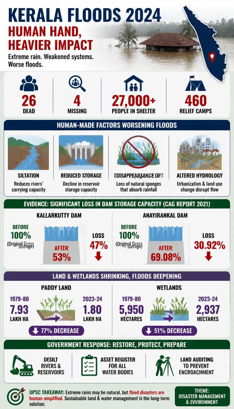
- The floods resulted in 26 fatalities and four missing persons, with over 27,000 individuals seeking shelter in approximately 460 relief camps.
- Key human-made factors contributing to the worsening floods include reduced carrying capacity of rivers due to siltation, decreased reservoir storage, disappearance of wetlands, and altered natural hydrology.
- A CAG report in 2021 highlighted significant fall in dam storage capacity, with Kallarkutty dam losing 47% and Anayirankal dam losing 30.92% of gross storage.
- The state government plans to desilt rivers and reservoirs, prepare an asset register for water bodies, and conduct land auditing to prevent encroachment.
Kerala Floods.jpg
Detailed Insights:
- Studies by Kerala’s irrigation department confirm that accumulated silt and sand have significantly reduced the water-holding capacity of rivers.
- The 2018 floods exacerbated the situation by depositing large amounts of sediment into river beds, further obstructing water flow.
- Rapid urbanization and changes in land use patterns have led to a drastic reduction in paddy fields, marshlands, and wetlands, which naturally absorb rainfall.
- Kerala's paddy land decreased from 7.93 lakh hectares in 1979-80 to 1.80 lakh hectares in 2023-24, while wetlands shrank from 5,950 hectares to 2,937 hectares in the same period.
- Extensive concrete roads and paved surfaces across the state act as impervious surfaces, channeling stormwater rapidly into rivers and streams, causing quick water level rises.
- The government's strategy includes urgent desiltation of rivers and dams to increase their capacity and mitigate future flood threats.
- Past sand mining in rivers, though widespread, was banned due to environmental concerns, highlighting a complex balance between resource extraction and ecological impact.
Key Concepts Involved:
- Carrying Capacity (of rivers): The maximum volume of water a river channel can hold and transport without overflowing its banks.
- Sedimentation: The natural process where eroded material like silt, sand, and clay settles and accumulates in riverbeds and reservoirs.
- Wetlands: Areas saturated with water, either permanently or seasonally, crucial for flood control, water purification, and biodiversity.
- Urbanization: The process of population shift from rural to urban areas, leading to increased concrete surfaces and altered natural landscapes.
- Impervious Surfaces: Man-made surfaces like roads and pavements that prevent water from infiltrating the ground, increasing surface runoff.

SuperKalam is your personal mentor for UPSC preparation, guiding you at every step of the exam journey.
Download the App


STUDY RESOURCES
CONTACT US
ⓒ Snapstack Technologies Private Limited