GS 1: Indian GeographyGS 1: Physical GeographyGS 2: International RelationsGS 3: Disaster ManagementPrelims
Chinese geologists question safety of Brahmaputra dam near India, Pg16
Chinese geologists warn active Paizhen Fault threatens structural stability of world's largest Brahmaputra dam, raising India's transboundary safety concerns.
Practice MCQs
862 Students attempted
Key Highlights:
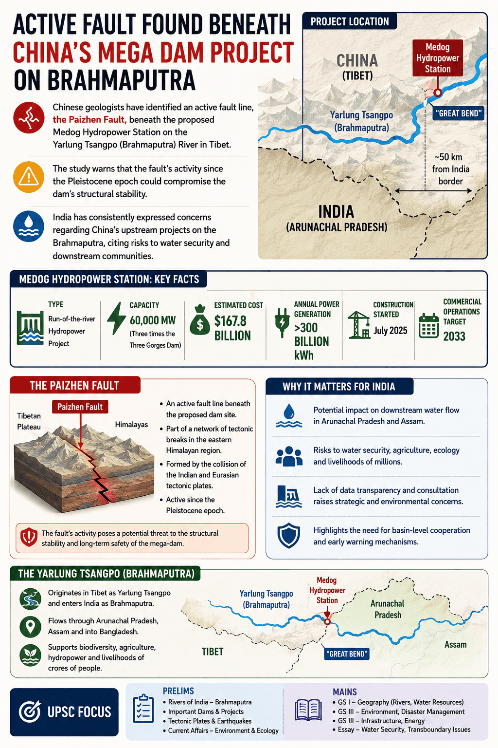
- Chinese geologists have identified an active fault line, the Paizhen Fault, beneath the proposed Medog Hydropower Station on the Yarlung Tsangpo (Brahmaputra) River in Tibet.
- This mega-dam project, intended to be the world's largest, is located near the "Great Bend" of the river, approximately 50 km from India's border with Arunachal Pradesh.
- The study, supervised by the state-owned China Geological Survey, warns that the fault's activity since the Pleistocene epoch could compromise the dam's structural stability.
- The project, with an estimated cost of $167.8 billion, aims to generate over 300 billion kilowatt-hours of electricity annually.
- India has consistently expressed concerns regarding China's upstream projects on the Brahmaputra, citing potential risks to water security and downstream communities.
Brahmaputra.png
Detailed Insights:
- The Medog Hydropower Station is a planned 60,000-megawatt run-of-the-river project, three times the capacity of the Three Gorges Dam.
- Construction officially began in July 2025, with commercial operations targeted for 2033.
- The Paizhen Fault is part of a network of tectonic breaks in the eastern Himalayan region, formed by the collision of the Indian and Eurasian tectonic plates.
- Researchers cited the magnitude 6.9 earthquake in Milin, Tibet, in 2017 as evidence of the fault's continued seismic activity.
- The study suggests that prolonged fault activity has fractured and weakened surrounding rock formations, making foundations vulnerable to damage.
- The terrain around the reservoir has a loose structure and weak cohesion, increasing the risk of landslides and slope instability, especially after water immersion or during earthquakes.
- India has formally conveyed its concerns to China, urging transparency, consultation with downstream countries, and safeguarding the rights of lower riparian states.
- The Yarlung Tsangpo flows into India as the Siang River before becoming the Brahmaputra in Assam and then the Jamuna River in Bangladesh.
Scientific/Technical Concepts Involved:
- Active Fault Line: A fracture in the Earth's crust where movement has occurred recently or is expected to occur, capable of generating earthquakes.
- Hydropower Project: A facility that generates electricity by harnessing the energy of flowing or falling water, typically through a dam and turbines.
- Pleistocene Epoch: A geological epoch that began about 2.6 million years ago and ended about 11,700 years ago, characterized by repeated glacial cycles.
- Tectonic Plates: Large, rigid slabs of Earth's lithosphere that move slowly over the mantle, causing geological phenomena like earthquakes and mountain building.
Previous14/14

SuperKalam is your personal mentor for UPSC preparation, guiding you at every step of the exam journey.
Download the App


STUDY RESOURCES
CONTACT US
ⓒ Snapstack Technologies Private Limited